Bays, docks and the front line coast
OS Landranger 179 – 25 miles
Just for the record, this part of my middle-aged mission, to cycle along the entire Kent and Sussex coast (it sounds impressive, but as I mentioned in the opening post, it’s really not), was the only one that didn’t begin with a train trip to the start line. It was also going to be the shortest, and therefore, in theory, the easiest.
The day before I had stretched my legs with the assistance of two very old
friends, and completed the section from Herne Bay on the north coast to Deal on the east. With the exception of one or two brief sections that took me up to the top of low cliffs, it was almost entirely flat. The day had ended at Deal, and in one of the best little pubs in the realm. Except that isn’t quite true. Not entirely the end of the day.
Without the need to catch a train to the starting destination there was no pressure to get up early on the 2nd August. And I didn’t. Not because the previous days cycling had taken a lot out of me (it hadn’t), but because after the few pints in the pub, we returned to the house, and in a long-upheld tradition, spent a few more hours entertaining ourselves with the music of our misspent youth through the medium of 45-year-old vinyl and Spotify. With Lizzy and Rory, along with the rest, blasting out our favourite tunes, the red wine flowed and we knew music…yes we knew music (until we were all mashed up and out for the count).
You can’t get away with doing that too often once you reach 60 and despite being hangover free, there was a slightly flat feeling as I said my goodbyes and started out south, past small fishing boats pulled up on the beach, and then past the Tudor fort to the right as you head out of Deal. It was just before 11 am. My earliest start. I had no concerns. Folkestone by around 4 pm, with a few contemplative stops with food and refreshments along the way. No problem.

First leg
On a long cycle I rarely manage to drink more than half the water in the plastic bottle. I can’t explain this. I just don’t seem to sweat very much and prefer to supplement fluid loss with a cup of tea or coffee every couple of hours. It’s probably not a very healthy approach but often I don’t even remember I have any water and so just plough on. So, when I broke out in sweat after 5 minutes of slow cycling along the beach bike lane, with the motionless sea to my left and Deal, merging into the town of Walmer, on the right, I figured something wasn’t quite right. It might have been the weather. It had certainly ramped up a few more degrees on the day before, but experience hinted at a lingering shadow from the alcohol consumed the night before. Resting up the bike I posted myself on a bench, took a long swig from the plastic bottle, and then sat and looked out across the Channel for a while. Actually, quite a while.
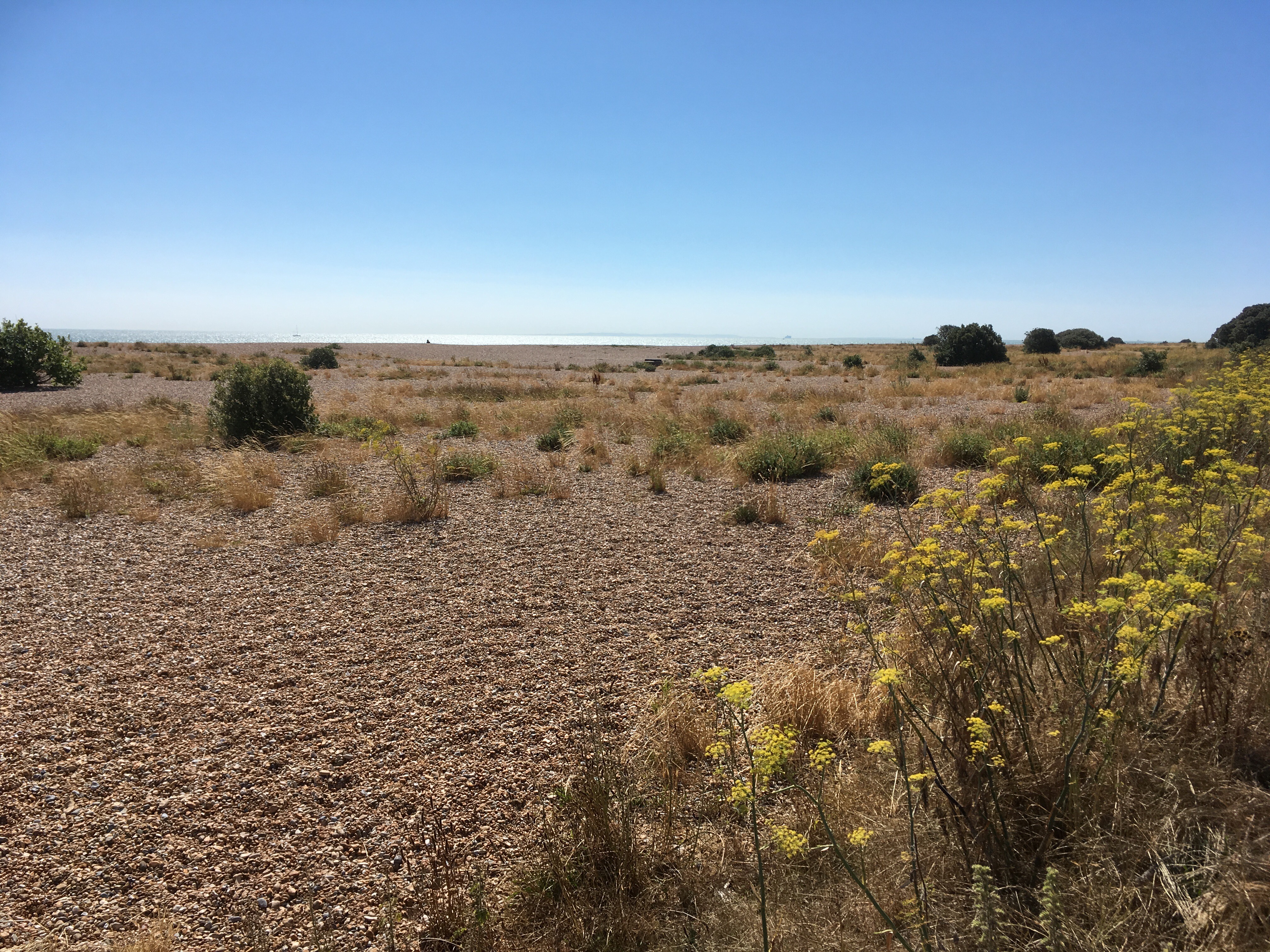
It was in truth a good moment. The wide shingle beach, fronted by marginal vegetation clinging to an existence at the south-east end of the country. Bright yellow flowers nearest the path and then various grasses and shrubs – petering out towards the water. The sea beyond sparkled in the mid-morning sun, and on the horizon, to the south, a thin ribbon exposing the continent. The sky above, nothing less than the cote d’azur.
The time on the bench had helped. Perhaps somewhat sobering; but I couldn’t afford to sit around all day and had recovered some energy and motivation. Past the impressive fortifications of Walmer Castle and a mile or so on the path met a narrow road lined by a row of good sized houses. Eventually a gate. Although the path continued along the shore, the bike had to go inland and shortly to the junction with the main road through Kingsdown. At the junction I looked ahead at an imposing house sporting a flag pole in the front garden which flew a large, perhaps defiant, EU flag. It seemed fitting, albeit soon (maybe) to being an anachronism.
Nearby was a small estate agents window – quite out of place it seemed. I took a nervous glance, but was pleasantly surprised by the prices on display. I continued through the village (two beach side pubs duly noted, but not now thanks), and then along a coastal road that ended at Kingsdown beach backed by low, heavily vegetated chalk cliffs.
Another short stop, taking in the view and general ambience, which was generally pleasing, and then up a fairly steep road with signs of a large campsite to the right (mental note). Beyond the campsite a smaller road to the left which seemed to head back towards the sea. Something registered from guidance that my friend had offered earlier in the day. It was something along the lines of keeping on the Oldstairs Road. But instructions can be ignored, and sometimes should be and The Leas was too tempting. The lane continued up for a while until it reached the golf course, and then upwards still and past a small row of houses which must have had glorious views of the channel. By now, high up above the cliffs and the road started to peter out. Although the Saxon Shore footpath continued south and towards a large landmark of some sort, it was made very clear that cycling is was not permitted. An instruction that I was prepared to obey, and so I stopped and abandon further exploration. Two men appeared a few yards away, animated and talking ten to the dozen, completely oblivious to my presence as they sought out butterflies that were flitting around the headland, and the men dancing around merrily like characters in a sketch from the “Fast Show.” The view was almost unbelievable. To the north the coast stretched away with Deal and then Ramsgate clear in the distance. To the southeast, and across the channel where numerous ships, ferries and smaller boats weaved towards diverse destinations and beyond Cap Gris-Nez and the sensational sandy beaches that, when the tide is out, run for miles towards Calais.
Years ago, 1998, with a few mates, and a day trip on a ferry to Calais with bikes, two of us set off into the hinterland. A few hours of lanes, hedges, villages, the odd beer and then we headed back in the afternoon after climbing to the chalk summit of Gris-Nez, just to confirm that the Nazi’s did indeed have bigger guns than everyone else. An aside within an aside. I recently heard that in the First World War, the Germans build some land based guns that were so big, much, much bigger than anything on ships, that they could fire a shell, out of earths orbit for f….sake, and up to 80 miles distance!!!!!! Accuracy was a bit of an issue, but by all accounts they shit the pants out of the population of Paris, which had hardly noticed there was a war going on and were so far behind the lines they couldn’t hear any firing…..well errr! Anyway, sorry but I was struck by this, particularly with the thought that had the Germans managed to break through to the coast around Calais and been able to deploy these monsters, they would have been capable of plonking these devastating shells into parts of southeast London – and how that might have changed things?
Back out now to the first aside. After my friend and I had inspected the crumbling concrete batteries at the Big Nose, we descended to the beach and set off back to Calais. The tide was out, the sand hardened as it had dried in the strong sun, and the wind from the west. No peddling required. Up to speed, let go of the handles, arms out wide…..and fly. Totally liberating. Back in Calais, the third and forth amigos, bike-less by choice, sat contentedly and outside the same bar we had left them at the hours before. Ah…but when in France eh?

But let’s get this back on track. Where was I? Ah yes, looking across the channel and watching two men leaping around butterfly catching (or hopefully just snapping). Sailing the bike back down the steep hill, past the club house and to the main road, it was a left, and then up a long lane which became a track that then worked up the dry valley of Otty Bottom (sorry, gratuitous and unnecessary I know). Some footpaths led off the track towards the high-cliffs to the south and inland well-tended fields stretched away to the north. After some steady climbing the lane wound into the outskirts of the small town, or large village, of St Margaret’s at Cliffe. I’d only been on the road for just over an hour but it felt like I’d been at it most of the day. Another pleasant place and surely with a hip café or two. Sadly no. A pub that looked a bit too upmarket for the likes of sweaty bikers, and a small shop that provided the standard range of processed meat, pastry products and cold drinks. I settled on some sort of vegetable wrap thing and chocolate milk, and then sat outside in the shade almost immediately regretting my culinary choices, which started to react negatively with whatever was left of the night before’s. That last glass of vin rouge was kicking back.
Pit stop over I cycled back past the white wood panelled Cliffe pub/hotel and then arrived at a green with benches which, due to the elevation and perfect weather conditions, presented a view across the Channel that probably couldn’t be beaten. I needed to make a decision now. Head on towards Dover, or, in the spirit of the challenge, head downhill to the beach and bay. Still not equipped with a map, and relying on the technology in my palm, I opted to go to the bay in the hope that there was a route out that would edge the journey further west. As the bike tipped forward down the hill, I almost immediately regretted the decision. The road was steep, winding and went on much further than the phone map suggested. Half way down there was a sign to some tea rooms and gardens. I made a mental note, and with some significant hindsight should have aborted the further decent and followed the sign there and then. I say in hindsight because the following hour turned into a bit of what felt to be an unnecessary struggle, and also a puzzle that having now looked closely at maps and through Google-maps, could have been to some degree avoided. A better and more rewarding route does appear to exist but shucks, how was I to know at the time?
I continued the freewheel decent to the bay. Emerging from the tree lined road and directly in front was the beach and sea with car parks left and right. Beyond these, significant chalk cliffs rose impressively. It’s midweek but nevertheless pretty busy. And why shouldn’t it be? A very interesting and picturesque location that maybe not too many people know about. And maybe just as well given that the lane leading down from the village is narrow and winding, and I am guessing that on a hot bank holiday (okay, I know such things rarely happen, not least because the establishment only permits one throughout the whole summer, which is thrown in at the back end of August – so you can work out the odds) the late afternoon exodus is the stuff of local traffic alerts legend.
The man-made interventions here are a bit rubbish to be honest. Extensive concrete car-parks, a nondescript pub cum restaurant and a couple of other random buildings. But the heavily tree lined backdrop and the rising white cliffs to the north and south of the bay more than make up for this. Along with more glorious views across the channel to France, the stream of boats heading to and from Dover just along the coast, evidence of a partly sandy beach, and I wished I could have lingered here a while longer. Shame but further progress was necessary.


There was nothing about the climb back up to the village that I was especially looking forward to. It was getting too hot, but more importantly I already knew now that the road was steep, winding, narrow and overhung by a claustrophobic tree canopy. I can reasonably happily plod the peddles for half an hour or more up a steady climb on a desolate moorland hill, but something about the short heaves up chalk land cliffs or Down land scarps leaves me a bit cold. All that said, there was little option, unless I was prepared to walk (and I wasn’t), so the wheels slowly turned again.
Reaching the turn in the road with the sign post to the Pines Garden Tea Room, I reconsidered the options. Carry on up to the top on the road, or take a risk and see if there was a route through the woods further west? In the end I wasn’t convinced that taking the garden option was going to be a good use of my time and the decision to continue on the road was made. Along, and then a sharp and steep curve to the left, and thirty seconds later I was in slow and hot and smelly pursuit of the municipal dust cart. I guess that if all it was collecting was dust the vehicle wouldn’t have been an issue, but those days are long gone, and so with the stench of several tons of modern household waste oozing from the rear, and with no real prospect of being able to find the necessary speed to put on a burst and overtake, I was resigned to the rest of the slog being just about as hideous as it could be. And of course, it was, although very near the top the truck stopped to collect a bins worth and I did make it past, a frustrating 50 yards before the summit.
On towards the village, now wondering how far I needed to go before reaching a road that would get me back on track towards Dover, and low and behold, a road to the left. As good as it looked there was a nagging doubt. If it hadn’t been for a man standing outside the door to a flat beyond, and smoking a cigarette, I would have listened to the doubt. Instead I took a punt.
“Excuse me,” I called across the greensward, “is there a way down here that will get me to Dover?”
The man gazed back at me, perhaps perplexed but more probably indifferent. After some seconds it was the indifferent response that I benefited from. “Yer,” he just about managed to utter, before taking another lug and turning away. Gee thanks!
As unconvinced as I remained, the man had given his verdict and who was I to reject the generosity of local peoples knowledge. The road seemed fine at first, albeit heavily fortified by speed bumps, vehicle restrictions, and a slew of the sort of signs I’d seen before that exclaimed privacy and something along the lines of “you’re not welcome” without actually saying it. I’d learned from previous experience that, as a rule, these sorts of warnings can be ignored, particularly if you are riding a stealthy bike. I carried on, encountering another refuse truck doing its business, but not representing such a hazard now.
As the housing petered out after a few hundred yards, the road deteriorated dramatically. The surface was more ruts than asphalt and some close concentration was needed. Along this track a couple of information boards directed trippers towards the cliffs and the remains of what seemed to be heavy duty World War Two artillery emplacements. With a bit more time, and maybe a little less heat, I might have taken time out to investigate further, but I didn’t, and a short while later had reached the effective end of the lane. A large and locked metal gate was a big clue that I was running out of options, but a footpath, lined by hawthorn and trees, led south, and determined not to give up so easily, I ploughed on. Eventually, and after a few calf and ankle scrapes with aggressive brambles and nettles, I broke free from the path and onto another track. Beyond was the site of the South Foreland lighthouse (not to be confused with the South Foreland Low lighthouse, which with some later research, I now realise I could have seen too, had I been brave enough to take the Pines Tea House route, which would also have got me to this spot – but such a minor detail).
I approached the garden and spent a few minutes sitting on the grass looking out to sea, and trying to understand what the phone map was trying to tell me. A track led along the back of the site which was managed by the National Trust, but it wasn’t clear to me that this offered a further opportunity to continue west. In hindsight I genuinely don’t understand how I managed to get this so wrong. At home I checked on Google and without any shadow of a doubt the track would have been the right thing to do, but on the ground something, either physical, or subconscious, prevented me from progress. Defeated I reluctantly plunged back down the footpath, along the rutted road, over the numerous speed bumps, and past the door of the man, who in my head, had sold me a pup. He had gone. Maybe for the best.
Soon afterwards I was on Upper Road, tracking the coast and riding more confidently west and towards Dover. Fields to the left with corn or wheat, or maybe something else, and Down land to the right. After a mile or so a small memorial by a gate at the side of the road explained that the field beyond was the site of a First World War airfield. Other than the two small granite plinths either side of the gate, there is very little evidence that Swingate Airfield ever existed. Some modern aerials suggested that there might still be some military usage but trying to imagine hundreds of Sopwith Camels landing and then taking off again towards a hideous debacle across the sea is now impossible.
Although the road tracked gently upwards at this point, beyond, the great tower of Dover castle emerged on the skyline. I felt now that I was making some useful progress and time was back on my side.
Over the brow of the hill and then a long downward, and very welcome, stretch that swept left and right and with magnificent views of the Roman/Norman edifice, and then with a turn to the left, the great harbour with boats and ships ready for ferry action. It was all looking good. At a sharp right hand turn a road to a car park and some signage. I stopped and took in the information that told me this was the White Cliffs, another National Trust managed bit of land. There was a paved path that tipped over the top, heading down and aimed directly towards the port but at an angle that would have impressed an Olympic ski-jumper. I don’t recall anything in particular that prevented cycling down this path, but I had a fairly good idea what the capability of my brakes were, and that didn’t include testing them on this natural big-dipper, as tempting a shortcut as it might have been.

Passing up the opportunity to keep to my principles, which as a reminder requires sticking as closely to the coast as possible, I passed on the chance to kill myself on the downhill path and continued the road decent. This was all very enjoyable but I was mindful that every action has an equal and opposite reaction, even if it’s not clear when that opposite reaction will happen. As long as I was going downhill it didn’t matter much, but at some point I knew there would be a backlash. But not yet. Upper Road continued over the A2 and then through woods which then give way to open views of the town and the bastions of the grand castle to the left. More downhill and the ancient walls and ramparts whizzed by and in no time at all I’m in the heart of what is arguably the most important, controversial, divisive, culturally significant town in the country at this time.
Dover (my Dictionary of place names tells me that it comes from the Celtic – Welsh – word for water), but that it relates to the river Dour, not the sea (and apologies here too for the Portilloism), is a place that has been passed through by more of us than perhaps any other place in the country, with maybe the exception of London and Stonehenge. Day trips, booze cruises, short, and maybe longer escapes tout directions, school trips, people looking for evidence of the past, van’s and lorries with nations trade, soldiers sent to save the day, people following in the footsteps of soldiers who saved the day but never returned, cyclists off to raise money for charity in the French style, workers off to find new opportunities beyond the grey, and even trains being carried to Dunkirk until not so long ago. Maybe I’m overplaying this card. Cycling through the town centre, and onward in a general direction that would hopefully get me out again as quickly as I got in, Dover could be any number of towns with similar functions though, with Ramsgate in mind, there are perhaps less than there used to be. Despite it’s current, and historic importance (you just need to have a quick glance up to the castle to understand this), Dover has a bad reputation. In every sense it is defined by its geography and topology. The imposing cliffs and harbour, which Dover is best known for, fronts up a relatively small town that snakes north with its various neighbourhoods squeezing east and west up steep dry chalk valleys. A quick look at an ordinance survey map shows the intensity of contours crammed into a handful of square miles, restricting the residential and transport links into the valleys, and where the hills flatten out above, the institutions of state that have claimed the high ground over 2000 plus years. I know Dover a bit. I’ve “used” it like so many others, to get to Calais and beyond. In Calais as a schoolboy on a let’s go mad coach trip, a group of us, straying too far from the centre, were confronted by some port boys on the prowl for lost mutton. It was the first time any of us had seen a flick knife, not in a shop window, but being pointed at us by a lad (who in a display of exotic caricature was actually wearing a dark blue and white horizontally stripped top), in a manner that suggested we legged it out of their particular postcode tout suite. And, with the anti-English abuse still ringing in our ears, we did. On the boat back, at the end of the day, the responsible teacher, a veteran of these continental escapades, commanded all the boys onto the top deck and then to present baguettes. Duly presented, Dad’s Army style, they were examined, and where found imperfect, broken open and the cleverly inserted flick knifes purchased by the more adventurous, confiscated and then thrown over the side. Somehow this intervention, despised by the lads involved, would mean that another bloodless year would be sustained in our part of south-east London but nothing more was said. How much weapon-based paraphernalia must lie on the sea bed of the Channel at this particular point?
I’ve also taken children to the castle. Albeit almost certainly over two decades ago, and with details now lost forever. A better family day anywhere else would be hard to imagine (Alton Towers excepted). As castle experiences go, I’ll put it out there that Dover stands at the top of the pile.
And more recently, and because I happen to know someone who has some links, I’ve been to watch Dover Athletic. The stadium, known as the Grabble, sits a mile or so to the north-west of the centre and half way up a chalk slope. It’s neither up nor down, but on both occasions my only memory is of bitter winds sweeping across the ground from one direction to another, sending clouds of litter swirling around the stadium and into the stands, with our Kirsty belting out “Days” atmospherically on the halftime tannoy system. As grounds go, and shaped by the pressing topography, it’s as vulnerable as you can probably get to the coastal elements. A bit like the town as a whole, there is no escaping the exposure.
There’s so much to consider. So many questions about nationalism, internationalism, history, the present and the future that could be considered. A nation now split over issues that this small town, with its large port, seems to represent. Imponderables that may never be resolved. But this isn’t the time and place, and my aim was, on this occasion at least, and perhaps guiltily, to escape as quickly as possible.
A few streets on, and because it couldn’t be avoided, I crossed the A20 and then started tracking it on a bike path inserted between the asphalt artery, and the walls and fences protecting and securing the harbour and docks. It was stinking hot. The traffic, endless lorries included, was belching out toxic vapours and throwing up the dust of industry. No place to hang around but it seemed to take too long to get somewhere less offensive. I’m not moralising here. It happens to be an economic necessity and I’ve driven this road a few times myself, but until we come up with a better way to move people and goods around, or heaven forbid, reduce our consumption needs, being on foot or peddle here is somewhere not to be on foot or peddle for too long.
Eventually there was a roundabout and a sign directing cyclists away from the A20 and up a hill. The South Military then leads to the Old Folkestone Road which then heads west and gently up through the Aycliffe area, a modest sized estate that lies under the higher ramparts of the Citadel, which I am assuming is less well known than the Castle, perhaps because it’s been a prison and Immigration Removal Centre when its military uses became defunct. At the top of the estate, before the Old Folkestone Road peters out (who knows when it stopped being the new Folkestone Road and made redundant), another cycle sign directs me up a path and then across a footbridge that spans the A20 below. The road is scythed deep into the chalk. No tacked. Want a railway between Folkestone and Dover? No problem – when they reached this spot in the 19th century they dug a tunnel a couple of hundred feet below where I now stood. Want a railway to go between Folkestone to Calais? Cool – they dug another much longer tunnel in the 20th. You wanna road from Dover to all points west? Ah…that’s a problem. Let’s just cut a monumental scar through the Downs. The folks at Aycliffe? Never mind, it’s just another Council estate. Cheap and nasty, nice and sleazy. Take a minute here. Look back to the town and the sea. Look at the road and how it bends up the hill and towards the rest of the UK. Look at the geography here. It is unique. It’s also a bit scary. A bit overwhelming. Very claustrophobic, maybe even inhumane.
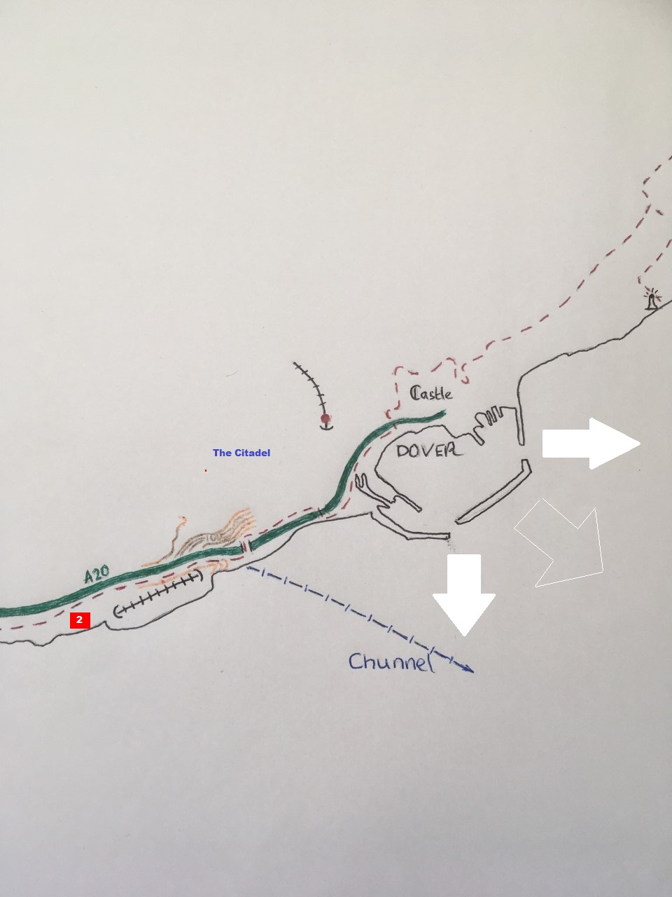
But not perhaps as inhuman as the bike path that lay ahead. Leaving the bridge I could see what appeared to be the next stage of the route, heading west and very much up the edges of the fields above the A20 and to the top of the headland beyond. The first short stage was tolerable, and before very long I was back on a short stretch of highway called Samphire Road, which was also accessed from the duel carriageway. At the end, if you were a motorised vehicle, you could re-access the A20 to your right, but for the more adventurous, to the left, the road tipped down into a tunnel that a notice informed led to Samphire Hoe Country Park. I was very tempted, but havering on the pragmatic side of calamity, and sensing that any easy decent would be countered some short time later by an appalling ascent, I gave it a tilt. The delights of the Hoe would have to wait for another opportunity, if it ever arose. I proceeded through some sort of anti-stolen moped barrier, which had the added covering of brambles, and started what was to become an attritional, and what felt like a very vertical climb up the hill on National bike route 2 (see map and white 2 in red box).
It’s quite hard to describe how bloody horrible this part of the route was. The path, to be fair, was asphalt. Given that the ground was bone dry this should have meant that despite the obscene gradient, a slow push in the lowest gear and sooner or later you’d get there. Instead, very quickly, and most annoyingly at the steepest points, the tarmac in many places had either disappeared completely, so you were now on dry earth, or worse, just partly destroyed enough that if the tyres caught the edge, instant injury might follow. Just partly destroyed ought to have been better than dry earth, but instead, largely because it was a haphazard mishmash of loose gravel, ruts, earth, cow pats, dry earth imprints of cows hooves, grass tufts and random stones, trying to peddle and at the same time trying not to fall off the bike, became a proficiency test of the most diabolical.
So, this was what I had encountered on National route 2. A completely unnecessary near-death experience in the midday sun. I eventually reached a flatter section and a gate to a field that I threw the bike up to and then propped myself against. I was exhausted. As I leaned heavily on the metal gate and gazed across the field towards the cliff edge, I was already composing an email in my head to go to the top of the topper most person in charge of bike lane maintenance. “Dear Sir/Madam, I recently had the the displeasure (and I use the word carefully, but without reservation) of flogging a proverbial dead horse up what is disgracefully and hilariously called National Bike Route 2. In the course of the…..etc etc. Yours in a humph El Colmado 57 “
Having thrown back a solid slug of water, and contemplating the next and final stage, I became aware of a familiar noise somewhere behind. A combination of crunching, panting and wheezing. Looking over my shoulder there was a fellow cyclist, panniers bulging, legs pumping and slowly climbing up the notional path and towards my position. Surprised at being joined by another human-being at this lonely spot I nevertheless summoned up the courage to say good-day as he brought his bike to a well-earned rest. A brief conversation started, me cursing the state of repair of the bike path, and he, rather dismissively I felt, saying it was nothing. I detected an accent, but in truth it could have been Geordie or another regional accent as far I could tell. A minute or so later, and a woman appeared on another bike, emerging from around the same hedge we had. Further “hello’s” and revelation that they were French (her English being better than his), at which point I started to apologise profusely for the catastrophic state of our National bike route 2. I felt, incorrectly of course, that I carried the nations shame for the state of disrepair on my shoulders. If I had had the strength I’d have probably sunk to my knees and prayed for forgiveness, but generously they seemed to shrug the ordeal off, bade their farewells and headed off, probably muttering worryingly about the English fool on the hill. C’est la vie. At least we had enjoyed the grand view back towards Dover and the Channel, and had made a slight acquaintance. I sent a text to my Folkestone contact to give a rough ETA, conscious that I was surprisingly behind on time. Figuring that it would be a bit weird to set off at the same time as the French couple, I stayed a few more minutes, and once fully recovered, started on what I knew was the last leg.

The path continued uphill but the gradient was less severe and consequently less arduous. On this stretch, set back from the cliffs by maybe 100-200 meters of Down land, I became aware of the distance climbed and the height of the land above the sea. Structures that could have been agricultural, but more likely military in nature, were evident and on one significant earth feature, covered in a layer of thick grasses, I spied the intrepid French couple having a nose around the sites. If they hadn’t been there, I would have probably stopped for a few minutes to do the same, but again it might have been a bit weird (in my head you understand – not necessarily in anyone else’s) and so carried on west.
One other unexplained feature on this stretch was what appeared to be an art installation. I can’t now remember what it was but I stopped for a minute and tiptoed across brambles to get a better understanding – which the reader will gather must have had no impact on me at all. In addition, and over the next few hundred meters, spanking new metal gates had been erected, seemingly randomly, at points along the path, and without any indication that they would be linked by any sort of fencing at some future point in time. I think there might have been three or four of these and the reason for their existence, other than they might also have been unexplained art installations, remained a mystery. Along with the fatigue, dehydration and possible onset of sunstroke, I began to think I was losing my mind and the understanding of everything I was encountering. I resolved to press on whilst I still had some marbles left.

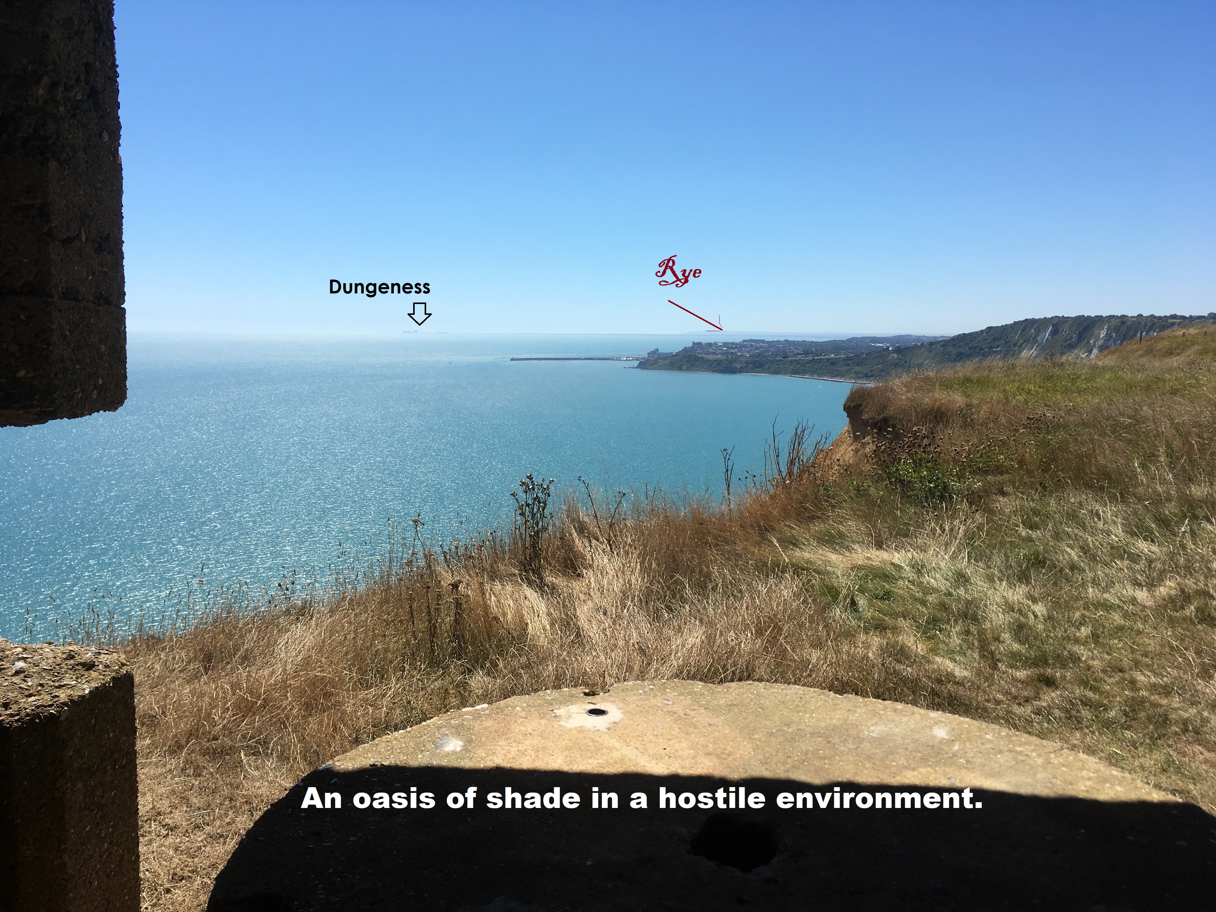
Finally, on cresting the high cliffs above Dover, the vista suddenly opened up ahead and without any ambiguity, Folkestone and its harbour, lay three or four miles down route 2. What was beyond, and due to the exceptionally clear conditions, was the sweep of coast west and south, past Hythe, up to the softly outlined shapes of Dungeness nuclear power station, and then further on towards the cliffs beyond Rye that hide any view of Hastings. Something to the left called the “Sound Mirror”* was observable but what it was (art installation maybe) remained another mystery.

At the top of another less intimidating rise, was what I assumed to be a concrete Second World War gun emplacement that offered a brief relief from the mid-afternoon sun, and a chance to take in the view over the harbour and beyond. Unusually, it wasn’t full of the sort of detritus normally associated with similar recent remains i.e. empty cider bottles, candles, lager cans, used spliffs, needles, fag ends, rags, burnt out bedding and condoms (to name but a few depending on local variants). Quite a pleasant place in truth but not time to rest a weary head. After five minutes it was time to head on, and not long afterwards I was on a track, and then a road close to the edge of the cliff. Just as the road started to wind inland, a left turn and then on the small Old Dover Road, which I guessed at some point would have met with the Old Folkestone Road at Aycliffe before nature reclaimed major parts of it at the Dover end (sorry, you’ll need to pull the bones out of that).
Apart from the glug of water at the gate where the French couple appeared, I hadn’t had a refreshment break since the average shop experience at St Margaret’s, and if a pit-stop was to show up I decided that I’d take it before dropping into Folkestone. And moments later, oh joy, a sign to the imaginatively named Clifftop Café. No brainer. I was shagged, and consequently just too not bothered to go through the pannier to find the padlock, and more annoyingly the keys to the lock, so instead wheeled and bounced the bike down some narrow steps, holding back to allow people with dogs coming past the other way, and eventually to the café and terraces with the great views. There was only one thing on my mind and after a short wait whilst a huge plate of chips, fish and peas was being dished up for a family, I got my hands on an excessively priced cold coke and a packet of cheese and onion crisps and then retired to a bench and table outside.
The moment was a bit like one of those masterpiece Guinness adverts of some years ago (sadly probably decades now). Particularly the classic surfer ad where “he waits.” I waited, about two seconds to be precise, and then flicked open the tins lid and emptied half the can down my throat Popeye style. And then……I waited.
And, at the very moment I opened the packet of crisps, with the thirst quenched and in urgent need of a saturated salt in-take attack, coming at a trot down the steps from the car-park above, and smiling widely, my friends, the French! “Hello again. May we join you?” asked the woman.
“Mais oui, mais, oui,” of course they could and with a little bit of the Del Boy Franglais, a hangover from CSE French and various Calais day-trips and other French foray debacles, I welcomed them to my table, the others of course being very full, and seemingly lacking in fellow cyclists.
Once they had secured their overpriced refreshments, and we had established that my Comprehensive school French was, by a factor of at least 100, worse than their English, we got to comparing notes. Mine was nothing to shout about, but they told me that they were from a mountainous part of France, near Switzerland, where the weather wasn’t always too great in summer, and they had flown over with their bikes and gear on the Sunday just gone (in a plane of course). Arriving at Gatwick they were greeted by the full-on traditional English summer, and then cycled from the airport, in the heart of Sussex, all the way to what they described as “north” London, but was in fact Wimbledon (an insignificant detail in truth). In a summer when our collective memories will only recall wall to wall sun and temperatures in the high 20’s and above all the way from May until September, we will forget Sunday, July the 29th. As we sat, melting in 30 plus degrees, I interrupted their narrative and asked if that was the day it rained?
“Oh yes, it did rain!” explained the man, with a jaunty laugh. “And it was very very cold too!” chortled the woman.
My jaw dropped at this revelation. Yes, I agreed to both, it had been a dreadful day. I knew this not just because I could recall being housebound by both the enormous quantity of rain that fell all day, and that it was bitterly cold too, but mainly because my two old friends back in Deal had spent that day on the London One Hundred charity cycle. Arguably the biggest cycling event of the year (when “the Tour” doesn’t touch our shores), it had been a catastrophic disaster for all involved and when I’d mentioned it to them the previous day, and before alcohol dulled the senses, I almost instantly regretted it. Three days after the event, it was clear that my friends had still been suffering post-traumatic stress disorder. Not only had they cycled the whole 100 miles, without crashing like so many others, but picking up punctures and freezing almost to death, they then got lost in London after the finish and added a further 17 miles before arriving at the house they were staying in for the night. A truly hideous experience that if it had been war survivors would have been mentioned in dispatches.
“Oh my God!” I said to the French couple. “I am so sorry, it was the most horrible day. Honestly, it’s been a great summer here.”
They laughed off the experience (maybe they too were suffering a sort of PTSD but in a more continental way to my friends). Moving the conversation on, as I thought best, they explained that they had spent the previous days cycling and camping through Kent and were now heading on down the south coast to see how far they could get in the next few days. Tonight, they intended to camp in Folkestone, though I wondered to myself where that might be. But they seemed to know better, and being such a jolly pair I didn’t want to interject any unnecessary spanners.
Conversation flowed. Clearly, we could have nattered and laughed on for some time more, but I had a deadline on a meal. I stood to go, and as we were saying goodbyes, and for no reason I can think of, I asked matter of factually, if they’d had any punctures?
“Oh yes,” the man said, laughing again. “Two!”
“Ah!” I said.
“Both on the journey to London from Gatwick,” chuckled the woman.
There was nothing for me to say. Of course they’d had had two punctures (not a bad hit rate), and of course both would have been in the worst weather Britain could throw at them this summer. I joined in the laughter (because what else was there to do?), and as I turned towards my bike looked around casually at the twenty or so other people sitting on the terraces and saw that most were looking at us and chuckling along too! It seemed we had become the centre of attention, and hey, why not? Essentially life’s just a gas.
Not much further to go now, and continuing west on the Old Dover Road until it met with the New Dover Road (still keeping up?), and almost immediately signs directing to the south, and a Battle of Britain Memorial. One of the great things about not over-planning is that stuff like this simply jumps out at you from nowhere and honestly, how could I not pop in for a few minutes at least.

A small, well designed building housed, what I guessed, was a museum but which would have to wait another day, and beyond a large swathe of closely cropped grass heading out towards the cliffs. At its centre a small memorial with three paths leading out and designed in the shape of a propeller. A propeller, funnily enough, in exactly the same shape as those at the noses of the Spitfire and Hurricane parked in perpetuity nearby, their fighting duties well and truly over but still looking a million dollars.
Onward and up Dover Hill (anyone would think you were in Dover, not Folkestone) to a roundabout, and then downhill in the direction of the port. A basic principle went out of the window at this stage when an opportunity to get coast side again presented to the left, but I was a bit behind time now and to be frank, of all the south coast settlements on my mission, Folkestone is probably the one I know best, following a move to the town by extended family members a couple of decades earlier, and before the completion of the M20.
Under the railway and left, the road snaked round right and then followed the old dock railway line, sadly no longer in use now that the ferries, and the like, sailed away for good many years ago. At the end of the intriguingly named Tram Road, a left under the disused railway bridge and it’s the old town with its pubs, pretty little houses and the wooden shacks a remnant of a fishing industry.
There was nothing more to see here. The purist in me, which had been beaten out of me on the climb up the bike route leaving Dover, would have carried on a bit up the coast road to the golf course with an impressive whitewashed Martello tower at its heart. But the purist spirit was lacking and instead I headed up the Old (and I have to say, pretty jaded) High Street and on to my tea and dinner, before catching one of the Javelin trains back to St Pancras. I can’t remember which super-fast athlete was doing this leg of the journey (it would have been an irony if it had been Chris Hoy), but, and this is important to know, it completed the seventy odd miles twice as quickly as the one the day before when “Mo Farah” had had the indignity of limping from station to station along the north Kent coast like a narrow-gauge Welsh slate train on it’s way up the mountain for the first shift of the day. The disparity in service between London, and respectively the north and south of Kent, is staggering. There are good reasons no doubt, but whilst it is entirely appropriate to give the Javelin the title of the UK’s fastest train for the southern journey, it’s almost certainly a breach of the Trades Description Act if applied to the north.
I didn’t send the email to complain about the cycle route out of Dover. Not at the time at any rate. It’s now early December and whilst writing this up, and hit by a sense of shame at my negligence, I managed to navigate through Dover Councils web-site and left a question asking if they could tell me who has responsibility to maintain the route. Just waiting….
* For the record, and because I have a tendency to hindsight after the transcript, the Sound Mirror that I had dismissed as an art installation, and had passed without further investigation was, in sharp contrast, a device installed sometime between 1916 and 1930 to detect incoming air-raids on coastal towns. There is very little on the web about this and other similar installations, but an interesting link which explains more is below. Check out the 200-foot acoustic mirror or “listening ear” at:
Denge sound mirrors
That’s all this time folks. More on Route 2 another day!
