Ben Nevis
1345 metres
4413 feet
22nd June 2024 and August 1994?
In the Bleak Midsummer – The Big Yin
When you stand at the top of Ben Nevis, the nearest higher point, roughly to the northeast, is in Norway. That means that if you manage to climb to this point, and unless you’re standing next to someone taller than you, you are the highest person on this part of the planet for 700 kilometres, in any direction. If you draw a line directly south, the first higher point is near Santander on the coast of northern Spain. If you draw a line directly east, and this is not entirely scientific, the first higher point is an undefined location north of Lake Baikal in Siberia. If you do the same going directly west, and again this is unverified, it’s somewhere in the Rockies in British Columbia, and not a million miles from Dawson’s Creek. Taking this one last step, heading directly north, the 4413 feet elevation height line goes over the North Pole, and I’d like to think all the way across the Pacific Ocean until you reach another undefined point in Antarctica (although it is possible that there might well be higher ground somewhere in the Chukotskiy Khrebet range of mountains in the very northeast of Russia and somewhere south of a tiny settlement with the unlikely name of Billings. *)
Of course this is all entirely academic (just to clarify, no academic research was involved), immaterial and perhaps even meaningless. But though Ben Nevis, compared with much higher, and indeed colossal mountains around the world, is relatively small fry, it represents the highest point on Earth for an astonishingly large part of the planet. Mind you, and for what it’s worth, at Oakwood Station at the northern end of London’s Piccadilly underground line (height 282 feet above sea level and approximately 4200 feet lower than Ben Nevis), there is a sign that reads ‘This station is the highest point in Europe in a direct line west of the Ural Mountains in Russia.’ Which also means that Ya Souvlaki, the Greek restaurant next to the station, is the highest kebab shop in a direct line west of the Urals too.
The first ascent
I first climbed Ben Nevis in the summer of 1993 or 1994. A family holiday at Dunoon, a three-hour drive south, on the banks of the Clyde estuary. It was hot, and the midge count was set at maximum (that’s eleven times eleven million per square cubic metre). With my brother-in-law and our respective sons, both no more than seven years old, we drove north, and eventually, after an excruciatingly long journey, arrived at the car park of the visitor’s centre, where we met up with the brother-in-laws father (who had come over from the east coast and, it transpired, in his role as a teacher, had previously taken many school trips to the top).
The visitors centre lies a mile or so out of Fort William and is not too much higher than sea level. Given that it is the biggest mountain in the British Isles, that means any walk to the top starts at or near sea level. So, you are in for the full slog.
Given the length of the drive, we eventually set off late morning and reached the top some hours later. Despite the mid-summer heat, a north facing gully near the top still retained a healthy layer of snow, which came with a calamity warning about its risks from my brother-in-law’s knowing father. It had been a long, hot day and the kids had been heroic. Despite the elevation and purity of the air, I can remember a slight disappointment in the view. At the summit there were no plunging vistas, just a rock-strewn plateau with the rounded summits of hundreds of similarly sized peaks disappearing in all directions. But hey, a minor detail.
By the time we began the descent it was late afternoon, and shades of guilt began to bite knowing that the two lads had so far to go before a well-deserved Irn Bru and mutton pie.
I would like to share one or two photos of this day, but due to a technical error (owners incompetence), I can’t. The technical error occurred a few hundred feet down from the summit, where, and I can’t remember the exact circumstances, my standard issue Canon instant camera detached itself from either my hand or bag and was last seen bouncing down a scree slope that stretched into eternity. For a moment it felt like a death had occurred. How ridiculous! Nevertheless, it contained real bonafide evidence of an epic day, which years later would have brought happy memories. Of course, children being children, the instant scope for adventure kicked in and they were both over the top and heading down the treacherous slope in pursuit before parental responsibility kicked in and they were brought back under control, and safety. Over the years that moment has come back to me again and again (possibly when risking life threatening dashes over insecure scree slopes), and I wonder if anyone ever found it. Highly unlikely, but I also wonder how long it would have taken before the elements did their worst and killed the film. Maybe not that long. I need to get over it.
The Second Ascent – Journey to Base Camp
Thirty years on, the journey to the visitor’s centre was from an entirely different direction and had taken a good deal longer than anticipated. I had an appointment to meet with my daughter (who would have been no more than two or three at the time of the first ascent) and her partner near Fort William on Friday the 21st of June, with the purpose of riding the steam train across the Glenfinnan viaduct on the Sunday.
Nine days earlier I left the south of England and headed up to Scotland. I had intended to make this trip the previous September to catch up with relatives, but after meticulously booking various hotels going up and back, I caught Covid a few days before and had to abort, losing a shed load of dosh on the bookings in the process.
Being June, and based on previous June encounters with Scotland, the prospect of a few days of nice weather led me to picturesque Stonehaven (on the east coast south of Aberdeen) for a couple of nights, and with the intention of launching north and then west to Achmelvich for a few nights camping on the beach.
On the second washed out day in Stonehaven, and having assessed the weather over the coming days, it was clear that camping anywhere in Scotland was no country for an old man.
And there was no going back opinion. The best of the weather (the distinction between best and worst was entirely marginal and should perhaps read “the best of the worst weather”) seemed to be further north and east. To that end I booked expensive rooms further up the coast. After a night in the previously unknown (to me) town of Tain, by Tuesday I was hunkering down in Thurso. On the journey up I had passed over the historical border of Caithness, now subsumed into the much larger county of Highlands. The road north is almost entirely coastal, but at some point I looked inland and caught a fine glimpse of the very distinctive peak of Morven (Fiona), the highest point in what was once Caithness. I was almost tempted. But it was getting on, the weather was entirely unpredictable, and I had already set my mind on an unexpected shot at John O’Groats. Some things only present themselves once.
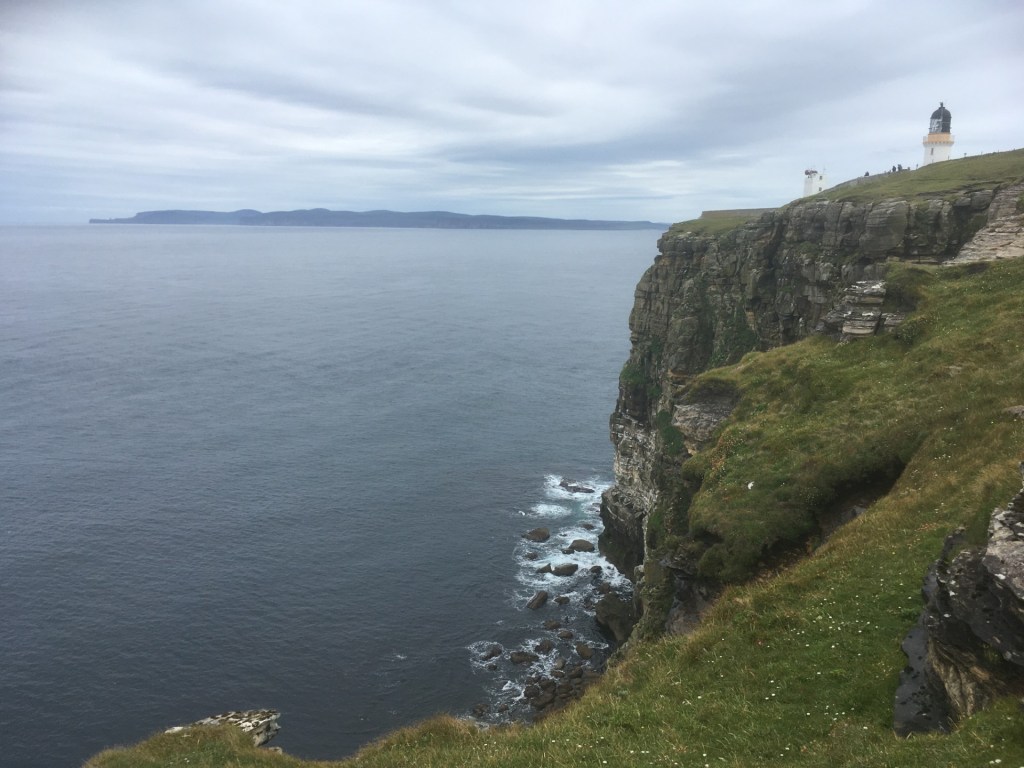
I’d booked two nights in Thurso, having had absolutely no intention of ever being there, but it was clearly the least wet part of northern Scotland at that moment in time, and the room was just about affordable. After passing Morven I eventually reached John O’Groats, and in almost horizontal drizzle (that was a first) I walked out of town and made it to the furthest north-eastern point on the mainland – Duncansby Head. An impressive cliff scenescape stretched south, which would have made a fine view had it not disappeared into the mist.

Duncansby Head – An impression
The following day I made it to Dunnet Head, the most northern point on the mainland. Hundreds of nesting seabirds, a couple of puffins after an hour trying to spot one (another first, and probably last), and murky views across the briny to the Old Man of Hoy, Scapa Flow and Orkney.
Spot the puffin
Earlier in the day I’d been tempted to nip over on a ferry, but the sea was excitable, and the prospect of being stranded on Orkney for a couple of days ruled it out. As I was about to leave the Dunnet Head car park I realised I had mislaid my binoculars. I retraced my steps and they’d gone from the spot I had put them down at. They say rural crime is on the rise. They had gone, and in my mind, there were only two potential culprits, but they weren’t fessing up. Humph!
I could have dwelt on this misfortune (I mean, I did of course) but rationalised that having finally spent fifteen minutes observing two puffins through them, they had duly served whatever purpose they had been manufactured for.
Thursday the 20th of June was the longest day, but with the dreich still lingering you wouldn’t have known it. Staying in the northeast was no longer an option. I needed to be at Spean Bridge, near Fort William by Friday, and there was just a hint on the weather app that there was a threat of sun later in the day to the west. I set off along the top, and as time passed the cloud slowly lifted. A long day’s drive, but with empty roads and the increasingly beautiful, glaciated landscape south of Loch Eriboll dazzled this old geographer’s eyes. Time was inconsequential. Everyone should do this trip once (free school trips for all kids in Britain to be made compulsory). By the time I was heading south (having abandoned any loose plan to get to Cape Wrath – the most northwestern point on the mainland, and mainly because it appeared to be almost inaccessible without detailed advanced planning), the sun was breaking through for the first time since I had left home.
At a remote village (that will remain unnamed on the grounds of national security, the possibility of being sued, and the avoidance of it becoming an Instagram “go to” location), a cafe had me calling. After an awkward few minutes, I’d eventually negotiated a tea and something to eat. Whilst we shared a common tongue, the person serving had so little insight as to what she was able to furnish me with that it took me to suggest a cheese roll before the eyes lit up and we were back in business. Sitting on a lump of granite, overlooking a small harbour, I sipped at the milky tea before taking a chunk out of the huge roll, stuffed with grated cheese and some pickle (I had had to suggest the pickle as a topping option).
One bite was more than enough. Without doubt the processed everything was quite simply the worst cheese roll I had ever had to ingest. I was sorely tempted to take it back and seek compensation on the grounds of it being a breach of the Trades Descriptions Act, but sensitive to the precarious nature of any business at the end of nowhere, I decided to swallow my aghast and bin it. I walked back to the car. There was no bin, but a sign passively aggressively instructed me to take my litter home with me. As I continued my journey the super sub sized disappointment sat on the passenger seat, cooking and sweating in its wrapper.
By now the sun was well and truly making an appearance. Glory bloomin’ be. Crossing the bridge at Kylesku, to the southeast the inspirational views of Ben More Assyant (the highest point in the old county of Sutherland), and its neighbouring peaks reminded me of what an astounding part of the planet this area is.

Slumbering peaks
An hour on and I was putting up the tent on the edge of the coast at the incomparable Achmelvich Bay. The sun slowly disappeared behind thin clouds, but the air was, for once, warm. I sat in daylight, with the gentle swell of the sea lapping the rocks below, reading Great Uncle Harry by Michael Palin until 11.30pm. Total peace. Instant karma.

Peace in our time. Midnight at Achmelvich
An early start on the Friday, but the drizzle and low cloud was back. Despite an overwhelming desire that I had clung onto for days, any thoughts of a second ascent of the most beautiful mountain anywhere in the world went out the window. I had climbed Suilven on my one and only previous visit in 2010. Just south of Lochinver there had been a carpark with a small cafe which marked the start of the long walk inland to the Falls of Kirkaid, and then on across the moors before the almost vertical climb to the low, rounded, and stratified summit of Suilven, with its unimaginably beautiful views in every direction.

Suilven… centre stage 2010 (note typical June Highland weather)
Now, arriving at the small car park, the gate on the road leading to the cafe was locked and it was clearly no more. My plan had been to grab a coffee and some breakfast before setting off towards the Falls. The cafe’s absence, the steady rain, the empty car park and the fact that a few brief sightings of Suilven revealed that most of it was sitting under a heavy cloud altered my thinking, and I drove on. It was probably for the best. Even with the weather being the pits the occasional views remained epic, especially the cluster of low peaks (including Stac Poli) on the route to Ullapool. But getting anywhere in these parts was just as epic, with hardly a hint of human occupation for mile after mile. Despite having set off by 10am it was well past midday before I pulled into Ullapool, and eventually obtaining some sustenance. At least, I thought as I chumped greedily on a rare crab sandwich (astonishingly the crab was not locally sourced), I had cracked the back of the journey and I’d be at Spean Bridge within a couple of hours. As I watched the small fishing boats (not employed in catching crabs it seemed), entering and leaving the harbour, I checked the map on the phone and entered my eventual destination. “What the %@*#?” I sighed out loud as the journey time of four hours flashed up on the screen. At least two middle aged couples strolling nearby stopped in their tracks before taking a wide berth around my bench, under which a discarded can of Tartan Super Strength gave the wrong impression. And that was by far the quickest route.
At this moment, a secondary plan (given that I had abandoned plan A to climb Suilven), to carry on south by clinging to the minor, minor coast road, was also kicked into touch. I reluctantly bit the bullet, headed back east to Inverness, then back southwest along the banks of Loch Ness, obscured almost entirely by thick vegetation and a thin veneer of mizzle. After a brief stop at the Commando memorial, just before five I eventually pulled into the accommodation at Spean Bridge.

“Hey Tam, do we get vitamin D rations too?”
My daughter and her partner had already arrived, having taken just a handful of hours to drive the 255 miles from the north of England. Just a few miles to the south the Big Yin heaved high above the lochs and rivers below, shrouded by clouds but challenging us to take it on. Tomorrow. I went to bed with a feeling of dread hanging over me like a low cloud, and then barely slept.
The Final Ascent
Despite reaching the main visitor centre car park at 9am we were lucky to grab what must have been the last parking space. A bright morning, but with leaden clouds gathering up the River Nevis valley, there was no sight of the summit. Never mind, it felt like a pleasant day and the sun might win out in time.
I felt pretty good, but it had been a couple of years since I had taken on anything similar (Snowdon) and had spent the previous year trying to exercise (relatively successfully) my way out of the pain and discomfort of a right heel disorder called plantar fasciitis. Because of this I had a realistic expectation of abject failure. I made it perfectly clear that if I gave up, the kids needed to carry on and I’d work my way back. As heroic gestures go, I had half expected some resistance to this suggestion, but the response was resolutely “Yeah, we were gonna anyway!”
The path started with a bridge over the river and then a gentle slope across a field to a stile over a wall. And that was the last of the “gentle”. The “gentle” had lasted three or four minutes. The plod had begun, and the well-defined stone-based path took a more or less straight line up the lower slopes of Meall an t-Suidhe, a subsidiary peak on the same massif. Within ten minutes, with the sun unexpectedly breaking through, I had stripped off the layers and was already down to the T-shirt. Now the bag was heavier, and if it was going to get hotter, then there wasn’t going to be any escaping the fact that I might end up in a spot of bother. The priority at this stage, twenty minutes in (huh!), was regulating the breathing, and not talking.
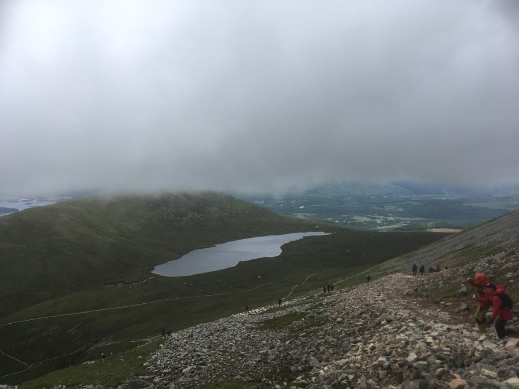
Over a mile in, and at a reasonable pace, the path crept slowly away from the river valley, but at an increased angle up! I was doing ok, and the no talking in the first hour policy was working. A bridge crossed a stream, with a small waterfall above, and a lot of picture opportunities. Whilst it was still clear, the sun had gone missing in action (confined to the lower valley and peaks to the south) and I had slipped a thin jumper back on. After the waterfall the path’s gradient steepened again, with a steady slog on up to Lochan Meale on a more challenging rocky surface. By now the path was busy. Many early risers had been to the top (some, including a friend of my daughter, doing the Three Peaks challenge) and were now hurtling back down. Those with walking poles were marching straight through the middle of the throng, seemingly indifferent to the safety of others picking their way gingerly up through the relatively difficult terrain.
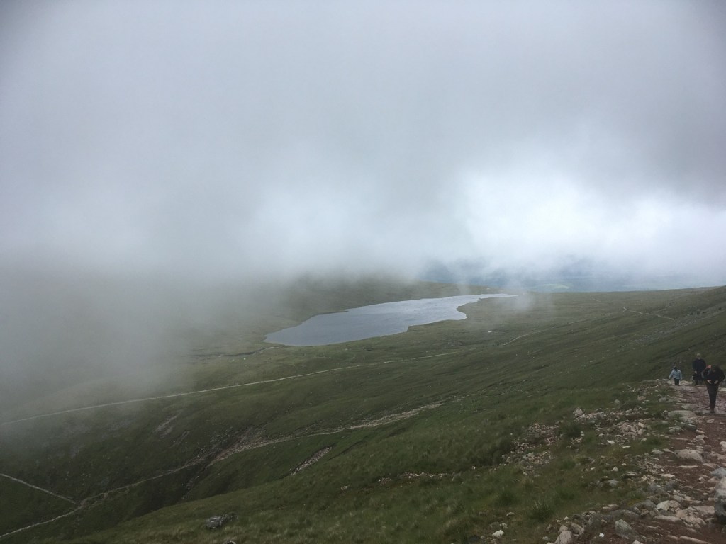
Towards the top of this grind, the path dog-legged directly back west for a distance, before another turn and a longer, less arduous climb to the north-east across boggier terrain on either side of the path. Time for a stop and some calorie intake (some sort of energy bar that my daughter had bought me after I had specifically requested a Mars Bar – she told me that the Scottish grocery shop didn’t stock Mars Bars – as if???). The views up the glen still hinted at the prospect of the elusive sun making an appearance at some point soon, but for the moment the sight of a couple of wild campers over towards the mysterious glacial relic of Lochan Meale, a distinct and spectacularly grey expanse of water at around 550 metres, was a salutary reminder that whilst in Scotland you can camp just about anywhere, actually putting that into practice comes with a degree of recklessness. (On a cliff top walk to Dunnottar Castle, near Stonehaven, a week earlier, a couple had pitched a small tent just off the path at the edge of plunging cliffs below. I wasn’t sure whether or not to tell them that, judging by the evidence all around, and the incessant rain falling on already saturated sandstone, the likelihood of a catastrophic collapse seemed high. At that moment I became distracted by a cow in an adjacent field, which was doing its level best to figure out how to unlock the large gate, and subsequently forgot to mention my concerns. The cow was demonstrating significant skills in its attempt to escape, but the reality was that it would take many more centuries of evolution before it was going to be able to unpick the padlock).
After crossing what was in effect the only less difficult gradient on the whole climb, it was back south and then step by step up and up. Precisely two hours after starting the journey, and with what felt like very little distance achieved, the cloud started to swirl into our faces and all the remaining layers were back on. Within minutes, Lochan Meale disappeared from view and for the next few hours.
The Last View
I couldn’t say for sure what the route looked like after that. The path became increasingly rocky and knee jarring, but to all intents and purposes I was getting on with the slow slog, in a world of my own, but mindful of the on-coming hordes making their various descents.
Another bridge across a tumbling stream, but I was too tired to register the aesthetics. The slope was now fully exposed to the cold westerly wind, and with the swirling mist there was no view beyond the next walker ahead. Despite its zig zagging approach to the summit, and presumably designed to make it slightly more achievable to the average walker, the path was remorseless. The final 300 to 400 metres was dedicated to navigating carefully through a barren scree slope. Somewhere down one of those treacherous slopes lay a Canon automatic camera, over thirty years old and with a film that had documented my last visit. A moment of regret, but after decades of rain, sun, ice and snow, it was time, as they say, to let it go.
Because there were no reference points it was impossible to say how high were, except, every few minutes I was being given an elevation check from the kids. Every step was now a struggle, but I had no doubt that I was going to get to the top. It would have been a major disappointment if I had stopped at that point, but the regular updates were having an unintentional negative impact, and so I asked politely for them to abate.
Evidence that the summit was getting closer appeared through the mist in the shape of a wide expanse of grey snow. In the sunshine it might have been white, but there was no indication that the sun had shone here since the last millennium. Surely it was just a few more minutes now.
Further time elapsed. My walking style had now been reduced to short forward steps, with my hands clasping my thighs. I have no idea what this brought to the party, but it felt necessary to maintain forward momentum. Another section of dirty snow that I recognised from my last visit. Like a saddle, the small patch of snow topped a ridge, that, in the appalling visibility, hid a plunging ravine, that certainly had stories to tell (not least the one told by my brother-in law’s father some thirty years before).
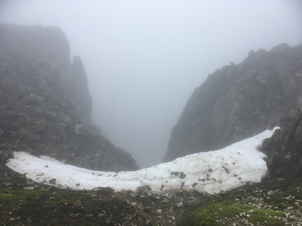
No warning sign necessary
I knew now that we were nearly at the top, and anxious to get there, had no curiosity whatsoever in peeking down the chasm. **
We were nearly at the summit when the gradient began to ease off, and the land began to flatten out. By now, and being so exposed, the wind was blasting across the shattered landscape, with waves of fine drizzle lashing into our faces. Miserable is one word to describe it. Mind you, compared to the many people wearing not much more than shorts and T-shirts, I felt like the best dressed man on the mountain.
As we approached the last few yards, spectral figures emerged, and disappeared just as quickly in the clinging cloud and mist. Bit by bit the handful of stone buildings that marked the top came into view and as impressed as I was with the fact that we had made it, my only objective was to get out of the wind and eat something solid, even if it was a fruit energy bar. A low structure with demolished walls on three sides grabbed my attention, and with the agility of a mountain goat I was over, in, and hunkered down in seconds.
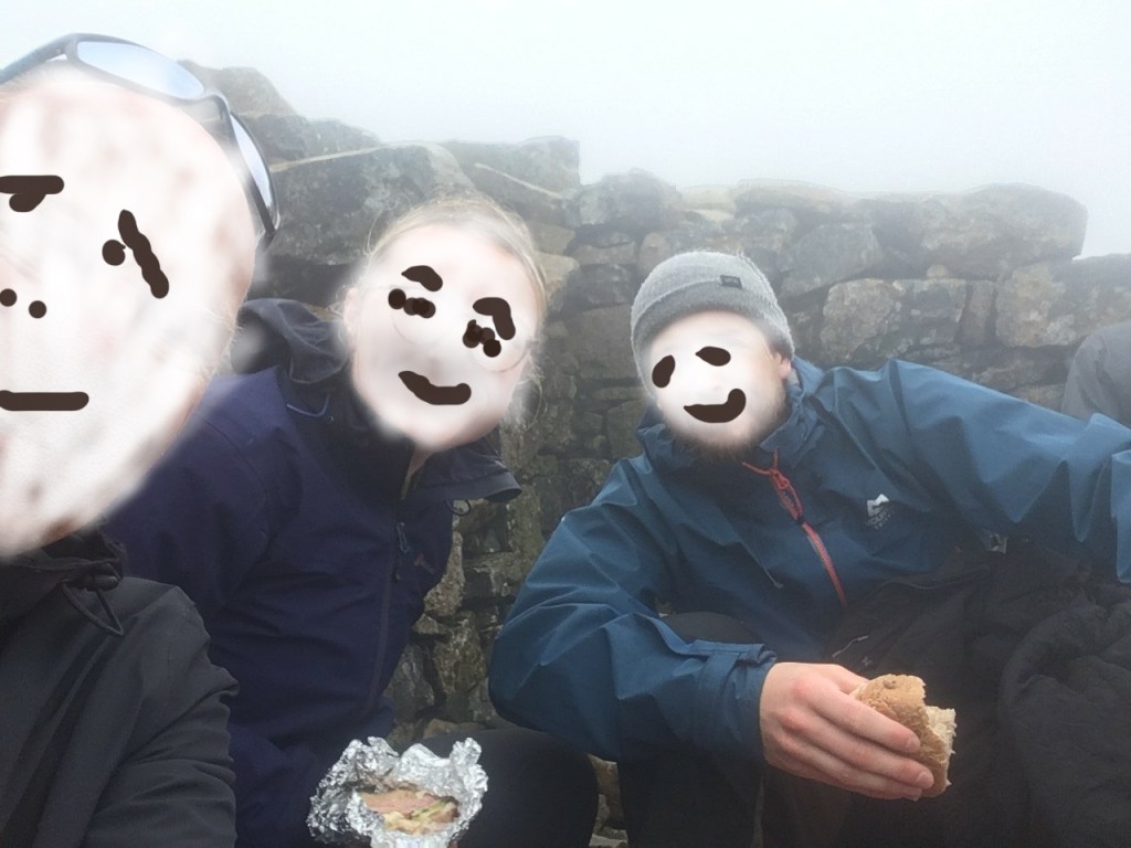
Proof…if any was needed.
After the much-needed sustenance break, my daughter and partner went off and climbed to the top of the stairs on the remains of the old observatory. I guess for a few moments they were the highest people on the planet for 700 kilometres (I won’t repeat the narrative around this). I didn’t have the energy, nor interest, and rationalised I had probably done it the first time (and that somewhere down a nearby scree slope a decaying roll of Kodak film held the evidence). In any case there was zero view, but for some reason it didn’t seem to matter. It was an achievement after all.
It had taken four and a half hours, and it was time to get back down. And so, slightly dried off behind the wall, we turned back and into what was by now a fierce, wet and bitterly cold wind from the west. It was just another hazard to endure. Going down is never as easy as you hope it to be, and with the conditions, and a still steady flow of people going in the other direction, it was step by careful step for an hour or so.
Most years in the last twenty or so I have a week or two away, somewhere to the south, mainly Greece to be precise. Most times this requires a flight out of, and then return to Gatwick. On the return flight the planes generally fly over the channel somewhere between Eastbourne and Hastings before banking and making the final descent towards the runway, almost always from the east and into the prevailing wind. And it doesn’t matter what the weather is like anywhere nearby (usually gloriously sunny), there is always, always, a moment when the plane sinks with a judder into a bank of cloud, remains in it for what seems like too long, before suddenly emerging just below. For a few minutes or so, the plane dances in a zone between cloud and clear air. Gatwick is the only place I know where this happens, but it happens every time, and I can only conclude that this part of the south of England rarely sees the sun.
As we continued to clamber down, we dropped out of the cloud, and momentarily glimpsed the world below. And just as quickly it was gone again. This process, now formally known as the “Gatwick paradox”, continued for some considerable distance before eventually our heads managed to break free of the cloud for good.
Lochan Meale….three hours on. Spot the difference.
We made it back to the sham plateau, with Lochan Meale in view. From nowhere I felt a bounce in my step and given that the path was relatively flat and easy, set off on what must have looked like a pantomime jog. I figured that I was the weak link and was holding my much younger and fitter comrades up. After a few minutes of this hop, shuffle and hope, I looked back and seemed to have put a few hundred metres on them. Encouraged as such, and with a mind of a 12-year-old, I continued to skip down what was now becoming more of a boulder challenge. I should of course have stopped at this point. So, it was almost entirely predictable that when I overextended my range and landed my right foot in an unorthodox position on an angled stone, which in turn rocked alarmingly, the realisation that something was amiss was immediate.
Having once managed to insert my entire right foot down a rabbit hole whilst replicating a perfect Glen Hoddle volley, I knew that the pain from this moment of indiscretion could have been much, much, worse. I sat down, and within minutes my companions had caught up. Apparently impressed that I had launched off so effectively on my own, they were naturally keen to press on. I mentioned my slight misfortune and admitted some discomfort. With some considerable effort we set off, me limping shamefully.
An hour on and we were eventually on the home run down the long straight path at the foot of Meall an t-Suidhe. Except I had endured enough. My ankle had lost the earlier intense pain but my energy levels, particularly my legs, couldn’t sustain the pace any longer. I stopped and told them as much and encouraged them to head on. I would see them back at the car park. There was no resistance to this offer, and off they skipped, no doubt relieved to be shot of the old whinger for a while.
It was a chance to take stock. Sitting on a rock for a few minutes I gazed across the valley below. To the west the sun shone on the tops of the lesser mountains. Looking back towards Ben Nevis there was no sign that the cloud base was going to lift anytime soon. Of course, it would have been better to have reached the top on a clear day, but I wasn’t fussed. I had been to the top on a clear day with my son, and on a climatically, diametrically opposite day with my daughter. Both occasions had equal value and were as meaningful on a personal level. Mind you, I was proverbially shagged, and any suggestion that I might be persuaded to accompany the grandkids up sometime in the future was for the fairies. It was unquestionably the last time.

Taking stock. The last look…
When I was younger, having Scottish roots, but growing up first generation in the English diaspora, whenever the subject of Ben Nevis came up (which was daily of course), my party trick was to inform the listener/s that it was 4412 feet in height. I didn’t get any help from AI, just a quick search of my memory banks and filed under “Useless Trivia.”
So, it has been a bit of a disappointment to find that searches on modern databases (my phone) contend that it is now 4413 feet. I guess a foot here or there is immaterial, but it has dented my confidence a bit. As a result of the last ice-age, the north of Britain, which was covered by huge ice sheets, is slowly rising. It is a consequence of a bounce back effect now that the ice has gone. Inversely, the south of Britain is sinking (after it was lifted like one end of a seesaw in the ice-age). Bad news for the south. Maybe Ben Nevis was 4412 feet in the 1970’s and has since risen a few inches to reach 4413. As I say, entirely immaterial.
* Checking heights on Google maps has been beyond my technical skills. Despite owning a very respectable Times world atlas, the level of detail needed to ascertain exact heights at specific points on the globe, makes much of the twaddle written here dubious, to say the least.
** At the foot of the north facing cliffs, approximately six hundred metres below the summit, I had noted on the 1:25,000 scale Ordnance Survey Explorer Map (2009), gifted to me before the trip, a red public telephone symbol located on the hostile terrain. I had never seen this on an OS map before. Red was obviously indicating an emergency resource. Curious to see if there was any indication of its existence on Google Maps, I discovered instead the Charles Inglis Clark Memorial Hut, which lies precisely on the spot where the phone is shown on the map. It was built in 1928 and can accommodate a fair few walkers and climbers foolish enough to take this route. I’m guessing that in an emergency it is just the sort of place you’d want to stumble across. That it’s not shown on the OS map makes no sense.
By the same token, and perhaps more importantly, when I looked on Google maps to find the name of the pub that we stopped at for a celebratory pint, just off the road to Spean Bridge from Fort William, there was no mention and no evidence of its existence at all. Maybe it was all just a dream? ***
Footnote
Sorry, I do go on!
*** My daughters partner was eventually able to solve the missing pub mystery. The Factors Inn, Torlundy. It’s by no means obvious on Google Maps, but does show on the OS map. There’s a thing. And very nice it was too.
