I was thinking about Scafell. Why had I never climbed it, wondering how on earth I would get the opportunity to do so now, and by extension reach the top of Cumbria. It had been bothering me, not least because I had climbed Helvellyn, a close second (or third as Scafell boasts two peaks, both slightly higher). But even Helvellyn was vexing me. It wasn’t on my itinerary, primarily because it wasn’t the top of Cumbria, but also because for the life of me my brain struggled to put together when and why I had been there in the first place.
It’s nineteen months since I started the county top challenge, and every week I’m finding out new things; not least that quite a lot of the on-line references, which on the surface look authoritative, often end up being unreliable; not deliberately, or due to casual research, but almost certainly because it’s a shifting shore.
My original list of counties, compiled just over a year ago from what, at the time, I assumed to be a reliable source, had included Scafell (which remains a legitimate target), in the county of Cumbria. My very large map obtained in December 2024 doesn’t disagree. So, some time ago, when a news article, or something similar, made mention of Westmorland, my ears started to twitch. Westmorland was a word I was certainly familiar with, but on checking the list it wasn’t to be found. I could have just left it like that, assuming that it was something along the lines of a generic term for a geographical area, but I’m beginning to find out that it’s best not to take anything for granted. I enquired further and soon discovered that Cumbria had been abolished in 2023 and divided in two, with Cumberland in the west and Westmorland and Furness to the east (are we keeping up?). And before anyone gets too nostalgic or sentimental about the demise of the ancient county of Cumbria, it ought to be noted that it (Cumbria) only came into existence in 1974 following the combining effect of, err… Cumberland, Westmorland, parts of Lancashire (!) and, (I can’t even believe the Yorkies let this happen without another civil war), part of the West Riding of – yup – Yorkshire! *
All these political shenanigans aside, once it had become clear to me that Westmorland and Furness was now a thing, and was added to my ever-lengthening list, I realised I had acquired a mighty peak by default. One could say of course that this is exactly the sort of bewildering quirk of the game that makes the exercise entirely meaningless. And, of course, one must agree, but hey, when I had climbed Helvellyn over twenty years ago, it had been an achievement, and by only a matter of a few metres is just a tad shorter than Scafell. It deserves to be a county top, and I am very grateful for that too.
Another notable claim to Helvellyn is that to the best of my knowledge it’s the only county top I have managed with both my son and daughter (with the possible exception of the City of London, which, I have just noted has disappeared from my latest definitive list).
I am unclear on the year, but from the information I wrote on the cover of the pack of the slightly disappointing snaps I took at the time, it was either the summer of 2003 or 2004. My children were teenagers and had been packed away for a week (voluntarily I should add) to a scout adventure centre at a place called Lochgoilhead, a remote location to the west of Loch Lomond in Scotland. The Scouting movement can divide opinion, but I don’t have a single bad word for the inner-city group that both my kids attended. Without any shadow of a doubt, it stretched them and cemented in them a desire for exploration, a sense of justice and a “can do” attitude.
Having said all that, whether they were thrilled by the prospect of another few days in the great outdoors under canvas, with their dad, at a campsite next to Ullswater only they can say, and I don’t intend to ask them now.
To reach the top of Helvellyn required me to do the following. I drove from London to Glasgow, spending a night or two with my Scottish relatives and brushing up on the lingo, before heading over the Erskin bridge into the Highlands, up Loch Lomond to Tarbet and then cross country to the remote settlement of Lochgoilhead. After meeting up I remember there was time for a march up one of the nearby braes to take in the breathtaking views down Loch Goil. The next day, with the rest of the squad, and the selfless volunteers who had made the whole thing possible, taking the long minibus journey back to London, I abducted my own and spent the rest of the day journeying down to Side Farm campsite, just to the east of the small village of Patterdale on the banks of mighty Ullswater in the Lake District. **
Our stay was for just three nights, and from memory the weather was kind. At the time my daughter would have been around 12 and my son 16. I recall that on the first full day we hired bikes and cycled on mountain trails up the east bank of the lake. About an hour in, one of the tyres on my son’s bike burst, leaving him to have to walk it all the way back. He seemed cheery about the prospect, probably delighted to have an excuse to spend some time apart from his sister and annoying dad. And who could blame him?
I can’t say with certainty that I can remember the exact route to the top of Helvellyn the following day, but I have an Ordnance Survey (Explorer OL5) map dated 2002 which fits into the likely dating, and a handful of photos, so here goes.
We drove the short distance from the campsite into Glenridding parking up near the large hotel… or did we? Yes, I recall that small boats lined the lake, dancing on the waves nearby… or did they?
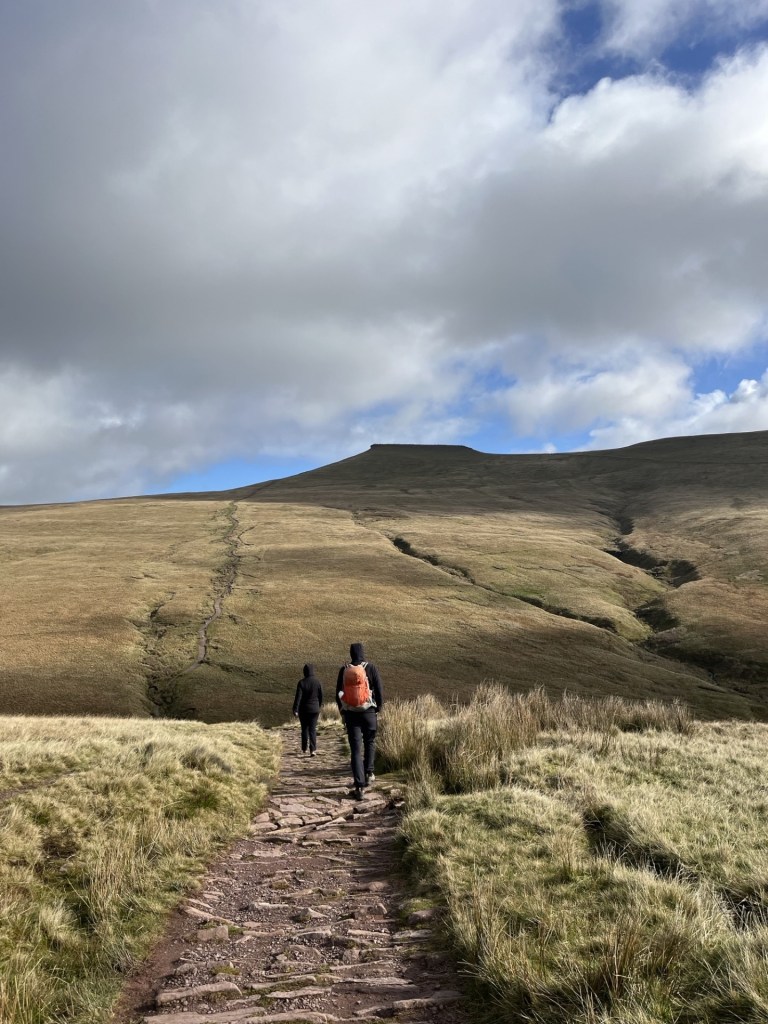
Whether either of the kids saw this as an adventure, or just a task that needed to be completed to keep me happy, only they can say, but full credit to them, once we set off inland through the village on Greenside Road, they were clearly committed to the cause. The weather was largely overcast but warm. Ideal conditions.
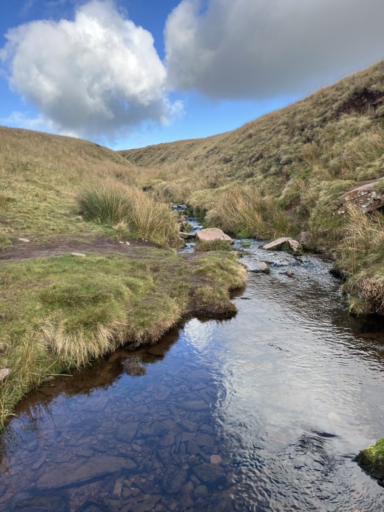
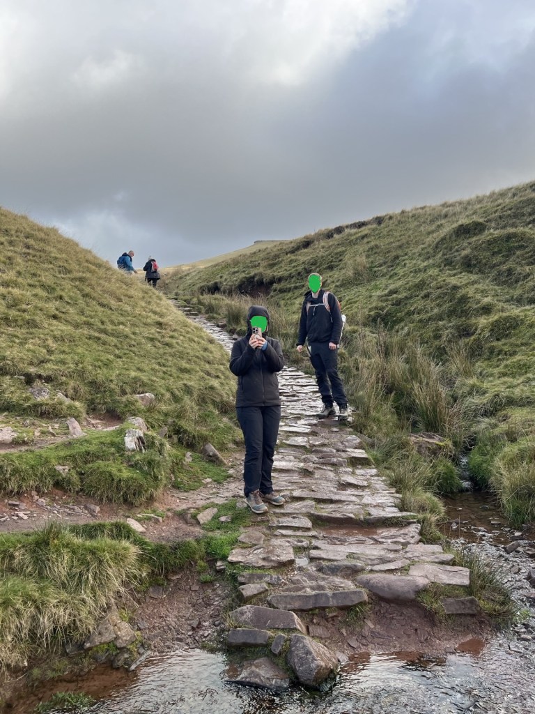
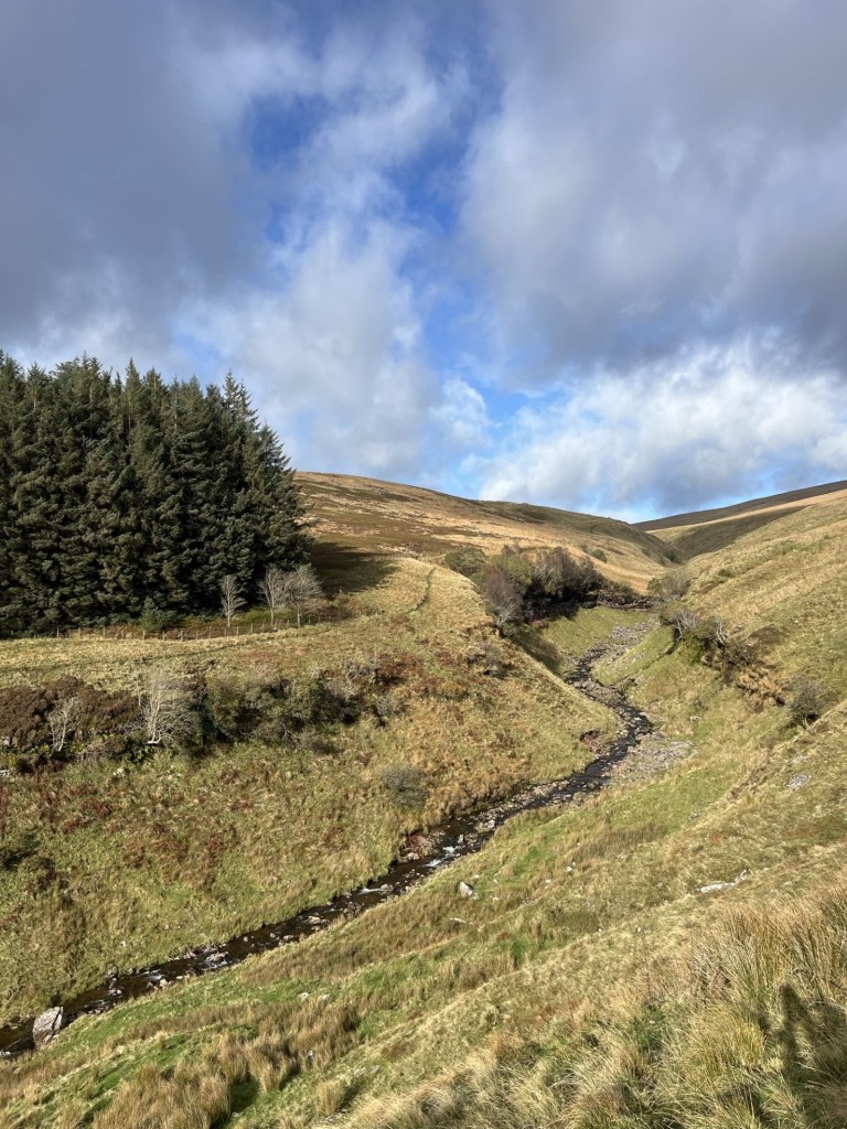
We continued up Greenside Road until crossing over a small bridge over a stream and then onto open countryside, with Helvellyn in view at all times. I confess that at this stage it does get a little hazy, but I think we must have taken the main footpath running southwest and to the north of Glenridding Beck.
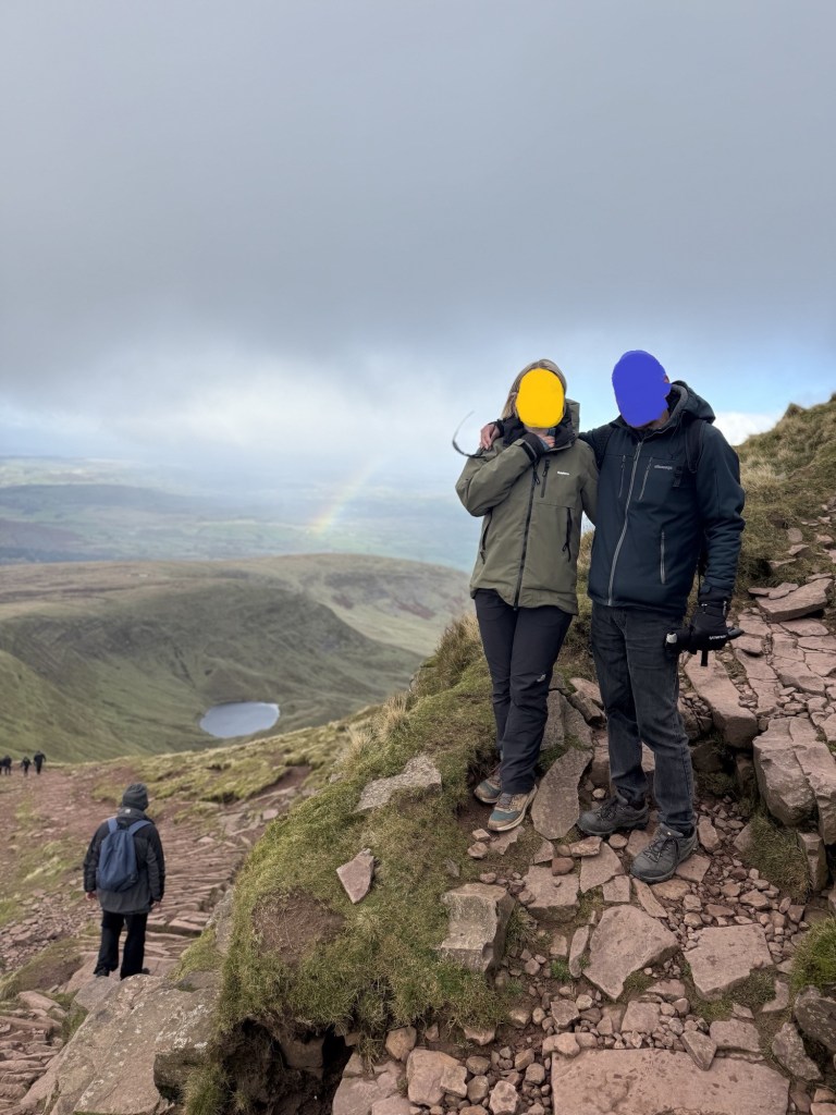
Looking towards the beast, with my daughter dressed completely inappropriately for upland hiking and asking if we were really going to go up that?
From cross referencing the photo with the OS map, I’m fairly sure that this photo was taken where Rowton Beck meets Glenridding Beck. The idea of taking on one of the almost vertical routes directly to the top was a non-starter.
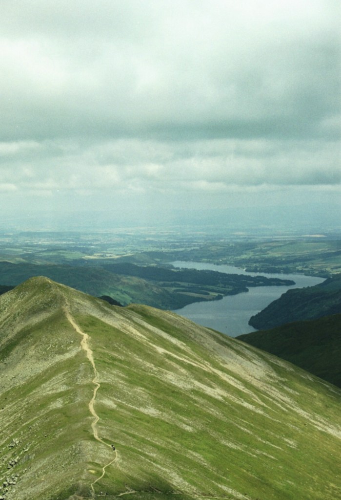
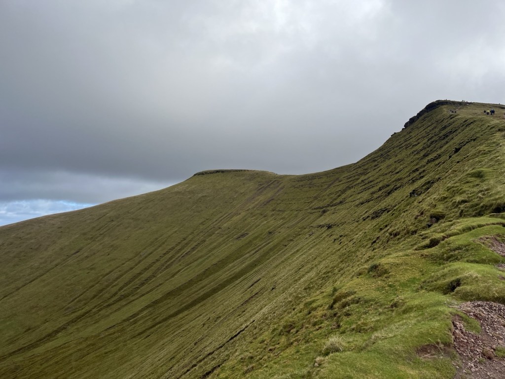
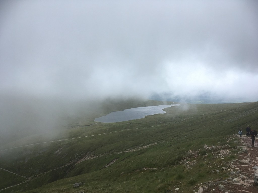
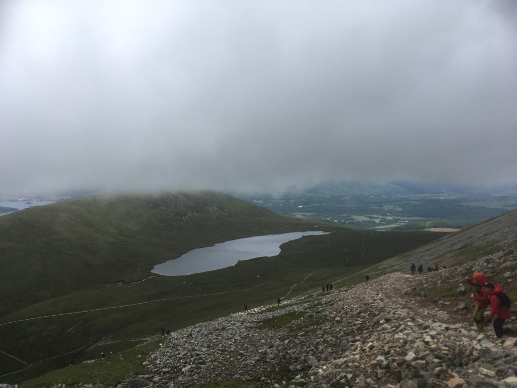
We followed the main path along Glenridding Common, and then started the zig zag climb up the slightly less challenging slope to the right, and eventually along the long straight path from Raise summit to the cairn at Whiteside Bank.
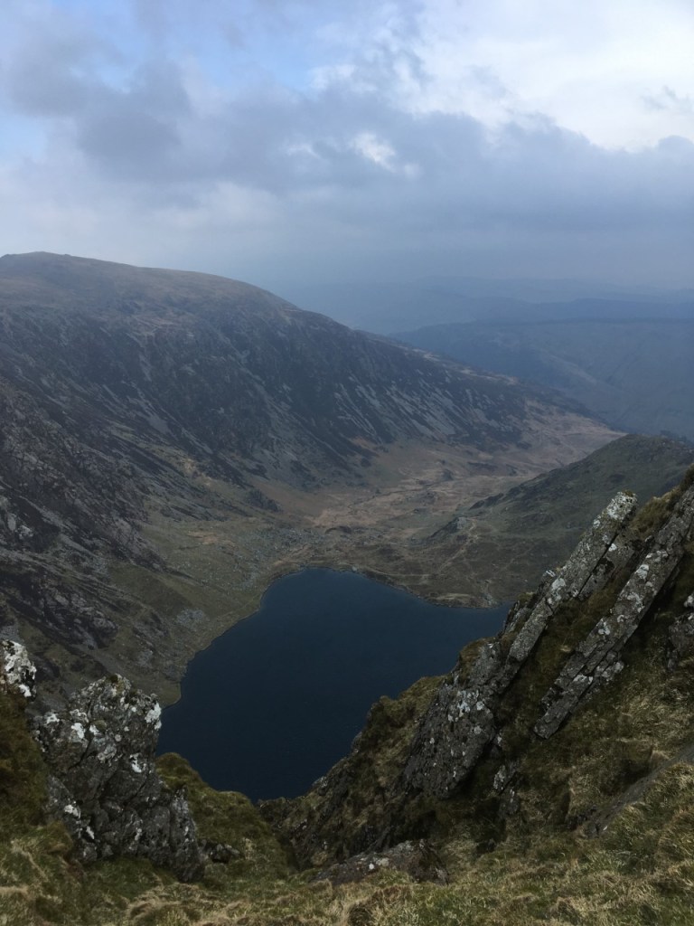
Looking back along the route from Whiteside Bank, with Ullswater beyond
Before I continue this reconstruction of what is now a somewhat ancient journey, a brief aside. A couple of days ago, I’m watching BBC News and up pops an article about the Patterdale Mountain Rescue Team trailing robotic legs. My eyes and ears were immediately alerted and for the next minute I watched how these carbon fibre leg braces, with some sort of battery attached, positively hurled the wearer up the hill paths. It seems that the number of call outs over recent years has escalated and the equipment allows the already stretched service the chance to get to their target more quickly and more efficiently, particularly as they also have to carry heavy packs. I couldn’t quite work out how they worked, not least because one would still be subject to lung capacity issues, but from what I saw they looked like the very fellows (as Billy Connelly once said) and may have to check them out for myself as the arthritis kicks in further.
What a beautiful sight – Helvellyn on the Beeb and in the safe hands of the volunteer rescuers
The associated message within the article was the significant increase in people rocking up in the wilds without the right equipment and then getting into trouble. Nothing particularly new in that message I guess (it’s an age-old issue) but from what I have seen recently on social media, it doesn’t surprise me. I have been getting lots more feeds showing people taking walks and hikes in remote locations and getting positive responses (check out Eddie Cheee in Scotland – he’s brilliant). I think they are great, especially when they show places I have known, but it’s almost inevitable that others will follow in their footsteps, many poorly prepared and equipped. And, when I have looked at what my kids were wearing when we climbed Helvellyn, I am the last to moralise on the subject. T-shirts and shorts! What was I thinking?
Back in the past, underequipped and irresponsible, we completed the next leg to the summit. This required trekking across the tricky ridge that would eventually lead to Lower Man (a distinct summit in its own right just to the north of the Helvellyn summit)
A random shot that could have been taken on the route towards Lower Man and possibly looking south-west towards Thirlmere, or north, or east-southeast, or, but honestly, who knows?
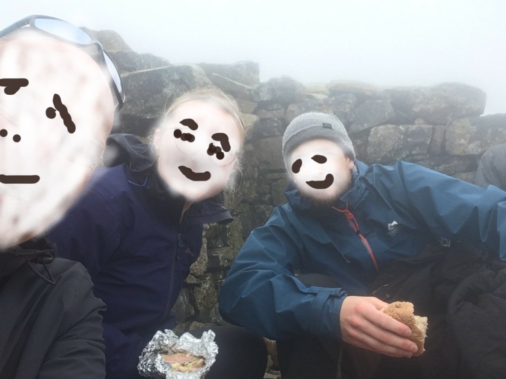
We eventually reached the top of Helvellyn, a relatively flat area of land but with the best views in town. I have some pictures of the kids looking suitably heroic (which of course they were), but for jolly good reasons (i.e. they definitely haven’t given me permission) here’s one of me to prove the event (heavily disguised of course as I haven’t given myself permission to post this into the public domain, primarily on the basis that my receding hairline was now in full retreat and the sideburns were entirely unnecessary).
Used for evidential purposes only but note that I for one was wearing something that could have kept out the rain for a few moments.
Suitably refreshed and slightly intimidated by the weather system pushing in from the direction of the Irish Sea, we made our move down. Easier said than done.
Hmm… could be trouble ahead. Looking south-west
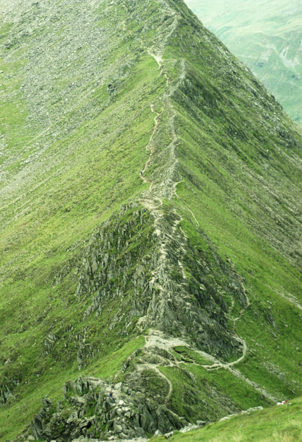
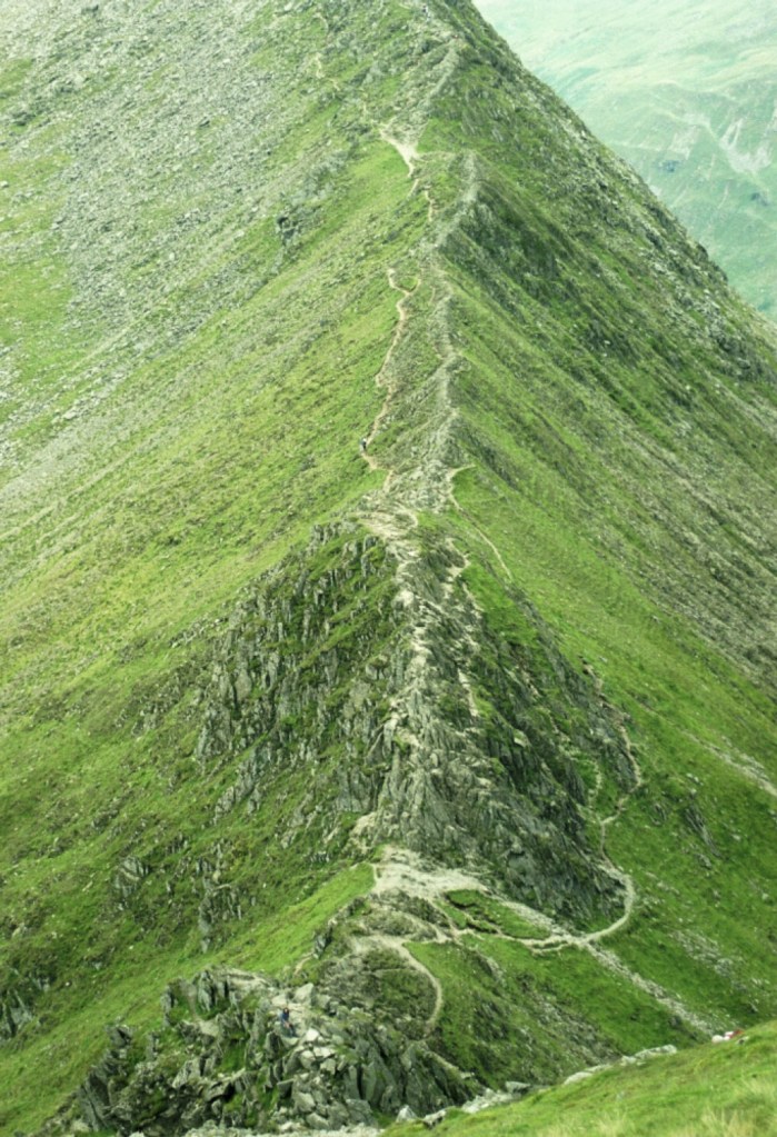
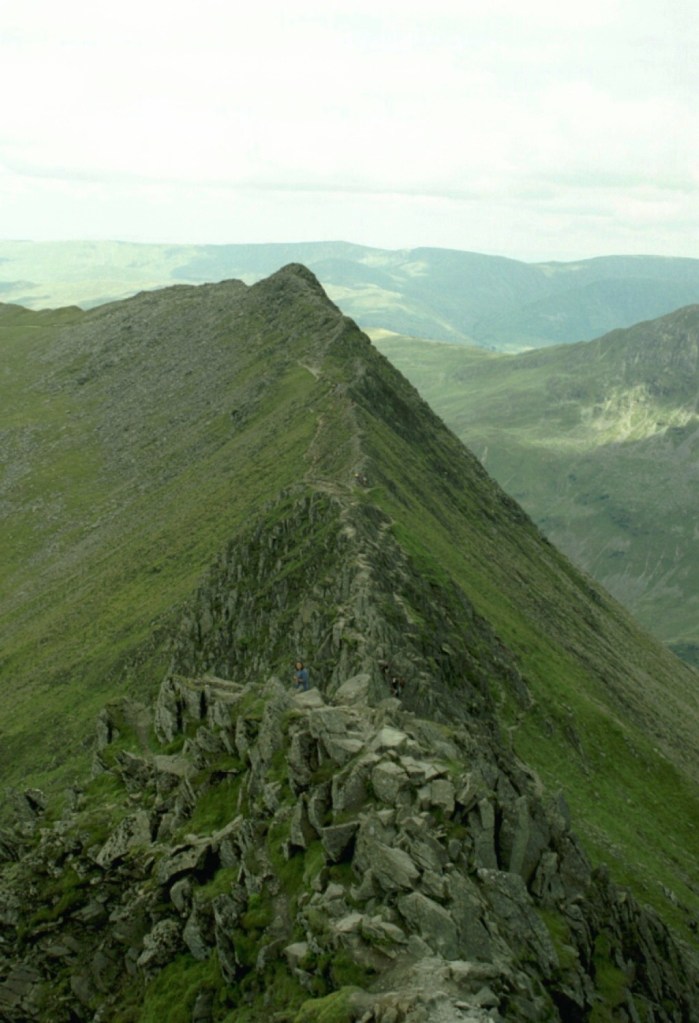
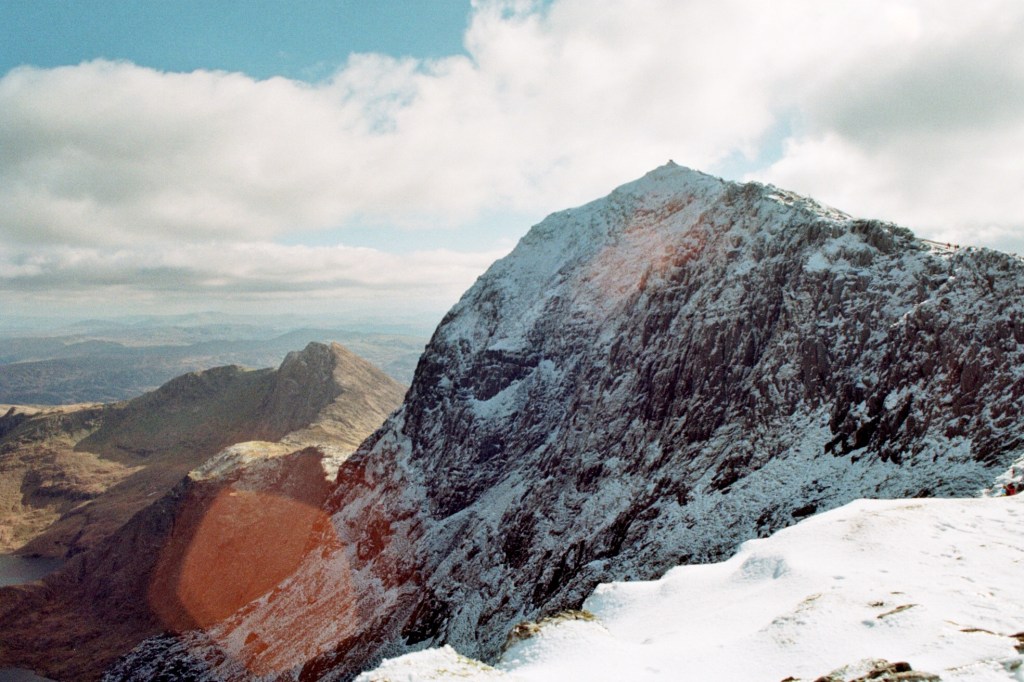
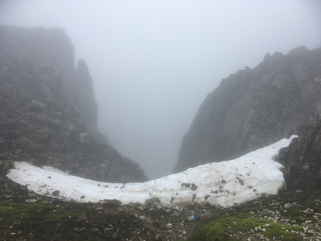
Anyone remotely familiar with Britain’s upland landscapes will know that Helvellyn is famous for its most distinctive feature. And here it is:
This is Striding Edge – no messing!
At the sight of Striding Edge, all jagged rock and with the land falling hundreds of feet away, potentially catastrophically, on each side, I recall suggesting a retreat back along the way we had come. It transpired that I was talking to myself. Both my children had left me at the top and were now clambering, skipping and jumping down and along the precipitous path towards, in my mind at least, almost certain referral to the authorities. I think I may have shouted some words of advice. “What the @*&% are you doing?” comes to mind, but it was probably more along the lines of “slow down and wait for me”.
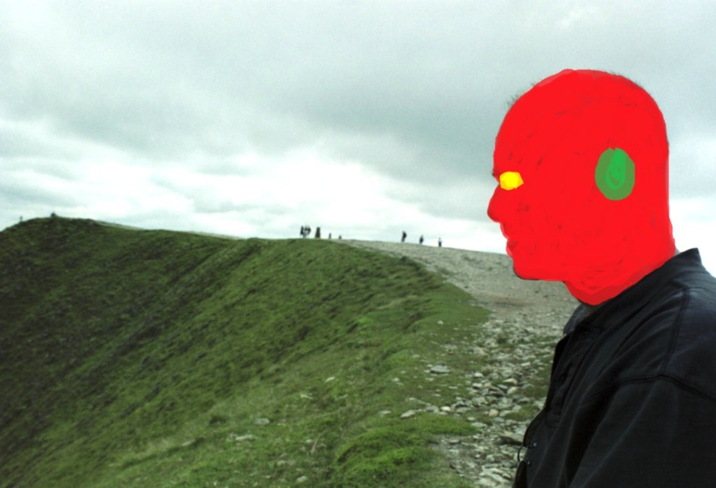
A little blue dot at about 100 metres, and just to the left of the thin path, indicates my feral son. I can just make out three people to the right of the path clambering over the rocks. The whole scene just shouts, DON’T.
Striding Edge is a classic example of an arete (strictly speaking, being a French word there ought to be an ^ above the middle e, but you get the idea), a narrow ridge dividing two valleys, and brilliantly Striding Edge is the first image to be seen on Wikipedia when you search the word. As striking and visually impressive as Striding Edge is, it’s about 400 metres in length and although at times you can follow a safe’ish path, quite a lot of it requires clambering up and down awkward rock formations. Great fun if that’s what you’re after, but nerve wracking if you’re responsible for two minors (technically at least). My granddaughter, just nine, has recently been bitten by the climbing bug (nothing to do with me I should add), and from what I’ve seen of her on the climbing walls she’d boss Striding Edge.
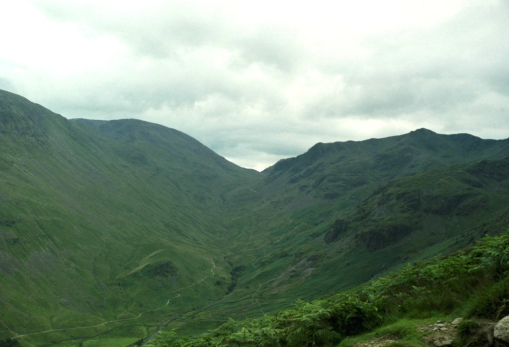
We did survive Striding Edge and eventually made it to the Hole-in-the-Wall, a dry-stone wall, unsurprisingly I suppose, where paths intersected and forming a boundary between the up and low land. I have a clear memory of arriving at this point and looking at the surrounding landscape. Maybe it was just a profound sense of relief that we had made it this far and were well and truly on the home run.
At Hole-in-the-Wall looking back up towards Grisedale Tarn (out of sight) and Fairfield Peak rising to the left, and Dollywaggon Pike to the right. BTW, I’m prepared to be contradicted on this if challenged.
We took the descending path over open country and covered the three or four kilometres back to Glenridding in less than an hour, and then on to the campsite for a last night under canvas. London and reality were calling.
Last evening on site and the weather on the turn
I started this by saying I had been ruminating on why I hadn’t climbed Scafell. The reason is simple. I haven’t been there yet, and to be honest, I’m not sure I will (from what I have heard it’s supposed to be tougher than Helvellyn), but if it happens or not it’s unimportant. What is important is that once upon a time my son, my daughter and I made an effort and reached the third highest peak in England. Hallelujah…
* A fascinating detail, particularly if you’re a Scot (I’ll say no more), when the Normans invaded most of what we think of as being Cumbria (and for want of a better description – other terms were available then), it fell under the governance of the Principality of Scotland. It did not feature in the Doomsday Book. By 1092, just 26 years after the invasion of England, William II, unable to resist the urge to invade, put paid to that. $£@%*&?’s!!!!!!
** In my old day job, I happened to manage numerous council blocks located in central London that bore the names of both Patterdale and Ullswater, along with other large blocks of flats named after other locations in the Lake District, many (having now looked at the map again) in the Helvellyn area. When they were built, just after the second world war, the lobby of each block had a large ceramic painting set on the wall that depicted the area it had been named after. From memory, by the twenty-first century all but one of these fine municipal works of art remained, the rest having fallen victim to refurbishment schemes or vandalism. I used to wonder what people living in these blocks must have thought of the daily reminder, as they passed through the lobby, that they lived about as far away as possible, physically, culturally and economically from the Lakes, and the uplifting images that they were confronted with. Many may not even have noticed. Some might have shrugged and cursed the irony, whilst others might have been inspired to jump on a train from nearby Euston station, and head north to explore.
My word. What a place! Sometimes you just get very lucky and remain eternally grateful for a while after (well, make up your mind – is it eternal, or just for a while?).
Pen y Fan is the highest point in the Unitary Authority of Powys. It’s the twelfth highest county top in the UK and the highest point in southern Britain after the magnificent Cadair Idris, eighty odd miles to the north.
Friday night with my daughter and her partner J in Bristol, checking weather apps whilst scoffing down an excellent take-away curry, and losing yet again at Catan. “So, are we looking to climb Pen Y Fan tomorrow?” J asks. “Yeah,” my daughter responded, “we’ve been talking about it for years.” That was true, not least because I had been nagging away about it for, literally, years (nine to be precise). Nonetheless, with conflicting forecasts, the certainty that there was going to be a brisk cold wind directly from the north, and in the knowledge that they had both done it several times before, I was prepared to be pragmatic. “I’m entirely flexible,” I added. “Maybe we just see how it is in the morning and if it’s not looking that good, we do something else?”
“We’re doing Pen y Fan dad. Get over it.” That was me told. I slept badly that night.
*
But, before we get there, I need to rewind and explain why climbing Pen y Fan had become something of an obsession for me.
Friday the 11th of March 2016, I was about to leave a hotel room in Weston-Super-Mare after a couple of days seeing my daughter and walking the local coastline whilst using up untaken annual leave. I had a plan for the day. Pop over the Severn road bridge, head down the M4 and climb to the top of Pen y Fan before driving back to London.
My phone rings. It’s my son and he sounds frazzled. My daughter in law’s waters had broken the night before, and far too many weeks before the baby was due. There had been no space in the local hospitals premature baby unit, so options as far afield as Liverpool and other points hundreds of miles away had been talked of before, finally, she was being offered a fifty-mile ambulance drive to St Mary’s Hospital in Paddington. It had been a hideously stressful night and just listening to the events had me shaking in my boots. “What can I do?” I asked. My son was reassuring. Everything was being done and there was nothing I could do but get on with my day.
After we ended the conversation, I wasn’t so sure, but rationalised that there really was nothing I could do. I drove up the M5 to Bristol and with the London option still weighing heavily on my mind, I shook it off and went west and then over the big bridge. I can’t explain why the need to climb Pen y Fan was so strong and why it had to be then. For one thing, the idea of climbing county tops had never entered my head and wasn’t going to for another eight years. Maybe I had seen a programme on TV about it, or just that visiting Bristol on a regular basis after my daughter had moved there had seeded my thinking. Either way, climbing a mountain, instead of going straight home and fretting around the house, felt like a suitable distraction.
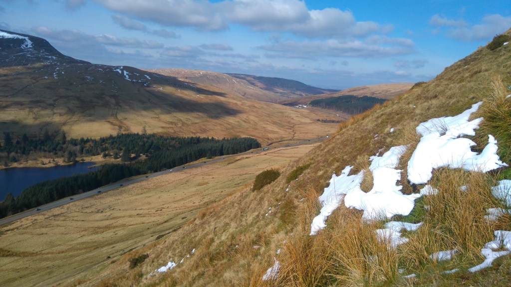
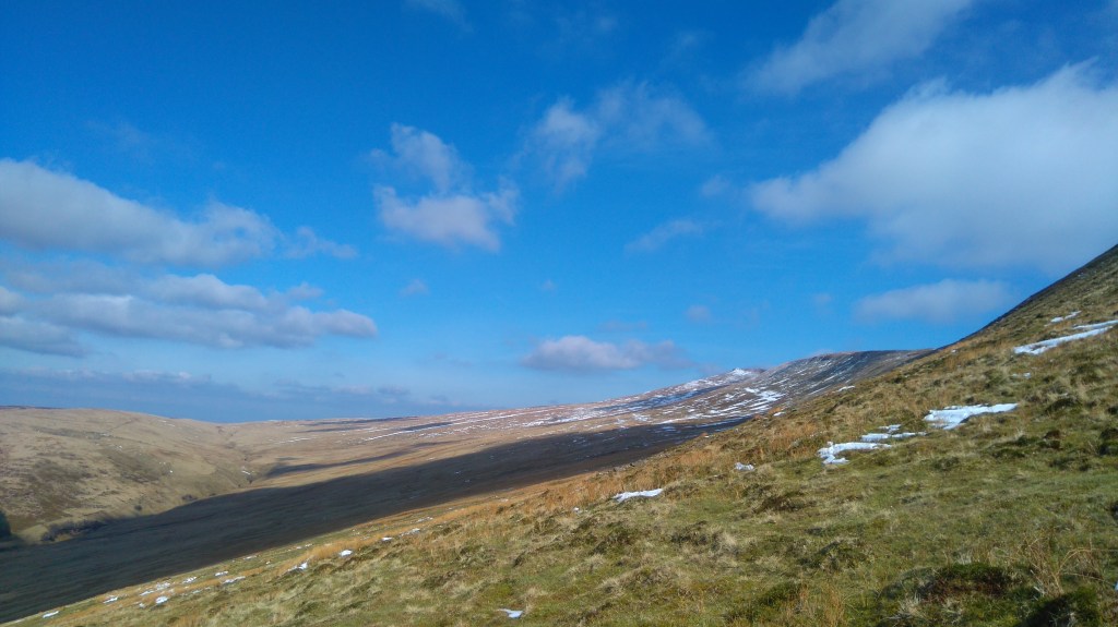
I drove up from Merthyr Tydfil and the valleys on the A470 and then into open countryside. The skies were cold winter blue, the land sparkling green. I had no idea what to expect, or pretty much where I was going, but sensing I was getting close I pulled up in a lay-by next to Beacons Reservoir, jumped out of the car and without any thought of whether or not I was in a good spot, or whether there was a more user friendly route to the top, I crossed the road, saw a footpath sign pointing over a wall towards open country, and was over without hesitation.
By the time I reached the first snow pockets I began to have doubts.
The lay of the land – March 2016
*
Back in the present, despite early morning rain the sun was making an effort to show off, and we bit the bullet. I drove (there is no significance in this other than if I read it again years from now, it will remind me that on the way back they both fell asleep) and instead of going all the way to Cardiff we headed off to Abergavenny before taking the majestic Head of the Valleys road west (my second experience of it in just over a month).
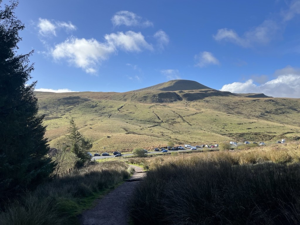
We arrived at the main National Trust car park and visitors centre at around 11:30, having passed the lay-by I had stopped at nine and a half years earlier. We were lucky to get a space and already streams of people were heading up and down the main trail which starts just to the south of the car park. Instead, we headed off on a flattish track (the Taff Trail) that took us north with the road and the impressive looking Fan Fawr mountain to the left, and a forestry plantation to the right. After a short while we were approaching the top of the pass where the A470 would start to descend towards Brecon, and past the Storey Arms Outdoor Activity Centre. This was the point where from now on the only way was up.
Looking west towards Fan Fawr. I was already panting Fawr air(no more puns.. Ed)
Due to the steep opening ascent, each faltering step started giving increasingly panoramic views of the surrounding landscape, particularly down the top of the Taff valley. The path underfoot was well trod and well-maintained, using slabs of the local stone, which, with the evidence of the alluvial waters in which they had formed millions of years ago indented on their surface, gave context to the surroundings.
After about fifteen minutes of this early lung breaker, we seemed to have reached a flatter section.
The kids, marching towards the top, or maybe not
For the first time it was possible to see to the top and a snaking path that headed directly (or possibly indirectly if you get my drift) to what I was assured was Pen y Fan. The only fly in the ointment, having made the initial effort to gain respectable elevation, was that the path was beginning to head back down. Don’t worry, I was assured, it only goes down a bit. Yeah, right!
Sometime later, and having lost considerable elevation, we crossed over a mountain stream.
Crossing the mighty Blaen Taf Farw
To the south it was possible to watch a stream of people gaining altitude on the main path from the car park. It seemed to me that they had only just about left the car park, confirming we had managed to lose most of the elevation we had gained in the first heavy lift. As I stood in the middle of the stream mulling over the meaning of life, my daughter and J seemed to be taunting me from the bank, taking photos as if I were some sort of endangered species (these have been deleted).
The paparazzi
Humph! Slogging on and straight up. Unremitting but at least the top was in view, seemingly quite close. There was a map consultation which I used as an excuse to slow down the ascent, and the truth was out. We were in fact looking at Corn Du, the slightly shorter twin peak to the east of Pen y Fan. Until now I had been putting one shaky leg beyond the other, head down and hoping it would all be over soon. Gazing now at Corn Du, a mere pretender, the little enthusiasm left in me started to ebb away. Even though it appeared to be in touching distance the stone path remained resolutely up. Don’t worry, I was reassured, Pen y Fan was just a short walk further on. It was time to trust in others, so on we (I) trudged.
Another 500 metres went by, and with almost no warning we were standing at a point where Pen y Fan came into view and the land to the north of the path dropped away dramatically.
The first sight of Pen y Fan, with Corn Du in the foreground.
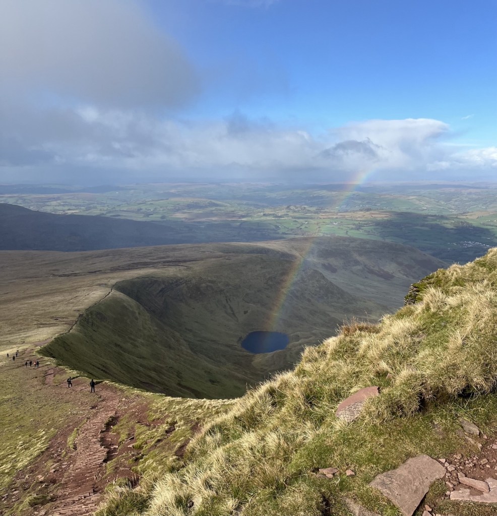
With this unexpected view, and the sheer drop down to a small corrie (the Welsh is Cwm) tucked under the mountain, a sense of validation began to return. That said, it took an age to complete the last 200 metres to the top of Corn Du. In my experience most mountains tend to ease off as you approach the top. Not here. Just short of the top of Corn Du we stopped and took the time to recuperate, take in the views and eat sandwiches. A rainbow had been developing far away towards Brecon. It was one of those days. Bright, very breezy but with scudding clouds menacing away directly from the Arctic. Time for some photos.
With the motivator on Corn Du with Llyn Cwm Llwch below
In the time it had taken to take this photo and grab another bite of cheese and pickle, the rainbow had suddenly shifted from what appeared to be the far distance to directly below, and almost magically issuing out and up from the corrie. Frantic scrabbling for phones followed by all around to grab the moment. A rainbow’s a rainbow – right? Ah! Not so….
This is not AI generated and no filters have been applied. Just physics
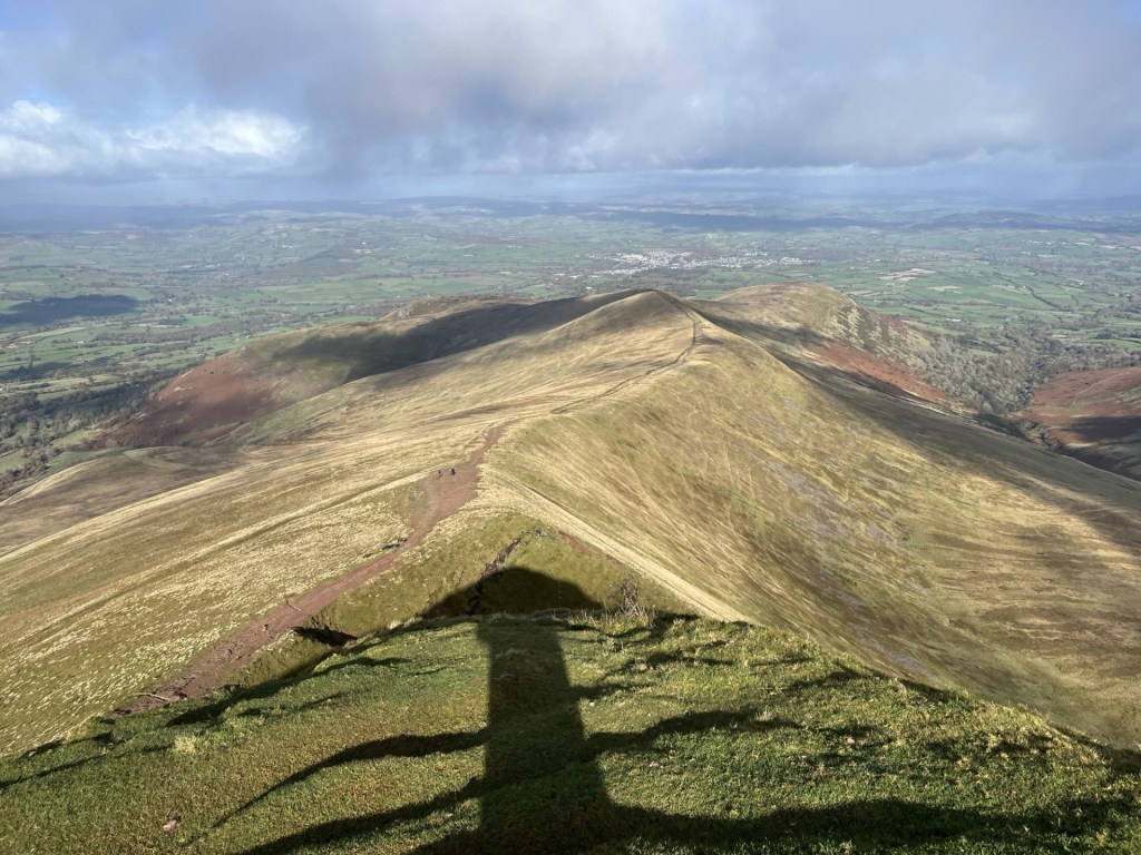
We carried on east along the high ridge, with plunging views to the north and a huge U-shaped valley disappearing to the south-east. J pointed out an abandoned reservoir further down the valley. Upper Neuadd Reservoir, empty for some years since faults had been found in the Victorian dam. J explained that they had climbed up from there a year or two before. It looked like a miniature wonderland but still showed as water bearing on the OS map. The views had me flipping out. Until we had reached the top of Corn Du, I hadn’t fully appreciated the landscape. It was a glacially shaped masterpiece, even more extraordinary in that it lies on a similar latitude to Luton.
Glacial delights and the remains of the Upper Neuadd Reservoir (left of centre)
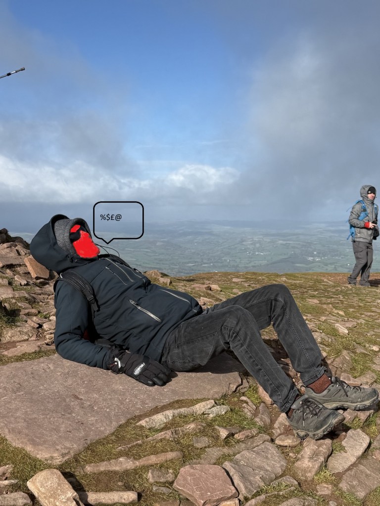
Getting across the ridge and covering the 300 metres or so to the top of Pen y Fan was relatively civilised. A bit down and then a bit up. At the final up, as the increasingly violent northerly hurled itself across the rounded top, my game was up and finding a large stone slab, lay myself down on alluvial remains.
This sitting position is unique in nature.
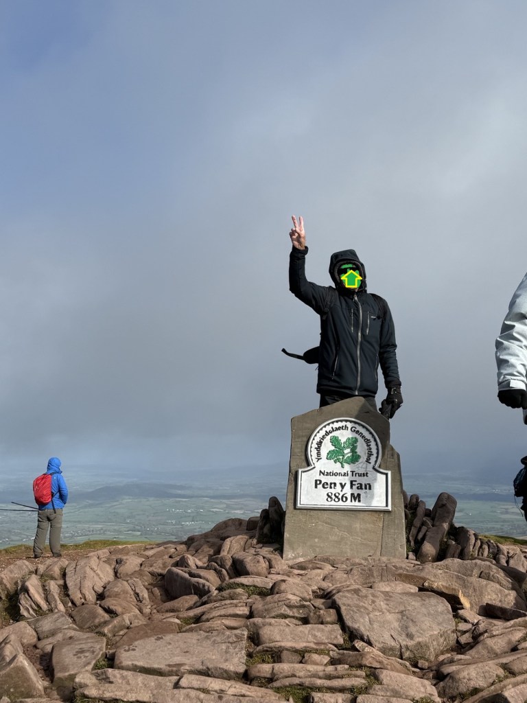
Once I had regained some composure, I crawled to the top for the obligatory victory photo (along with several dozen others doing the same).
Time’s up – now clear off.
The views in all directions were outstanding. Powys is the biggest council area in Wales, and from what I could tell you could see most of it, along with most of the rest of Wales. More glaciated U-shaped valleys lined up to the east facing north.
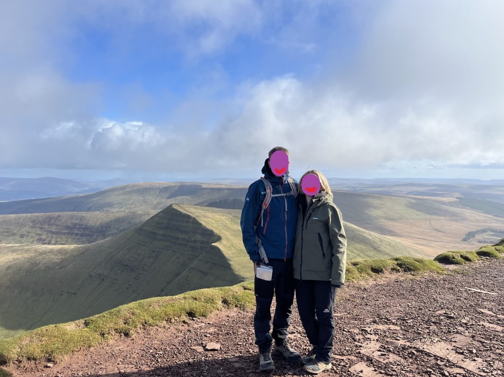
My compadres complimenting the unique landscape
Pointing towards Brecon and the whole of Wales, and 1500ft of elevation under the belt
After soaking up the moment we started back along the ridge towards Corn Du. An almost constant stream of people was moving in the opposite direction, and quite a few of them seemingly dressed for a different season. There is a Welsh joke and unprintable poem, that claims every Welsh person has been to the top of Pen y Fan. Obviously not true, but from the numbers making the journey it seemed to be a national ambition.
Instead of going back to the top of Corn Du we took the lower track to the south just below the summit. It was at this point, and just before we were about to emerge back onto another ridge, that the sun disappeared, the sky turned grey, and a furious hailstorm crashed in at too many miles an hour from the north. One look at the direction of assault was enough to tear lumps of skin off your face, and more than one other walker was reduced to tears. We hunkered down with our backs to the wind with just a few tufts of grass to give protection. It helped, and within a minute it was over. I stood and started to carry on walking. A mistake. As I emerged onto the ridge proper, a second and even more violent wave of ice bullets blasted into me. Having moments earlier sacrificed the relative security of the grass tufts there was no escape other than drift down the slope to the south. It made no difference and all I could do now was surrender to the moment. I stood with my back to the onslaught with hood up and completely accepting the conditions. I suppose knowing that it would be over in a minute or two helped, but in that moment, I don’t think I had ever felt so alive.
Counting hailstones
It went as quickly as it had arrived, and we took to the descent, observing the wreckage of humanity that had taken the full force and gathering their senses as they continued up. With a warm sun back in control it was a shame to be exiting the mountain, but you have to come down sooner or later. Halfway down a middle-aged man with some writing on his clothing trudged past us on the way up.
“I think that was Pen y Fan man,” J commented. Interesting, I thought, who was Pen y Fan man, I asked.
“Pen y Fan Dan. He climbs the mountain every day for charity.” *
As we approached the bottom of the path a beautiful waterfall plunged down to our right and begged to be photographed.
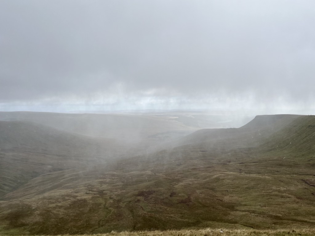
The view of the waterfall as it should have been
The view of the waterfall as it actually was. Boy oh boy! A picture can paint a thousand words, and in that moment I had none.
It was a last chance to look south and back down the valley. Nearly ten years before I had climbed over a wall and began a yomp straight up the side of the steep slope leading up to the ridge south of Corn Du. I had no structured plan other than getting to the top and then heading north. Despite the early cold it had warmed up, and I was having to de-layer. Whether I was sweating due to the weather, or my advanced state of anxiety, I had no idea, but one thing was for sure; I was beginning to wonder what on earth I was trying to prove. Patches of snow began to appear. I was about two thirds of the way to the top, breathing heavily but still intent on reaching the ridge when a ping went off on my phone.
“They’re in St Mary’s hospital now.”
I looked around. It was a beautiful spot, but the text was all I needed to bring me back to my senses.
The point of reality and return – Corn Du in the distance. March 2016
I believe in the meditative power of walking, but also in the adage that there’s always another day. Pen y Fan was going to have to wait.
I scurried back down to the car and three and a half hours later was parking up outside the hospital on South Wharf Road, Paddington. It was my first encounter with pay by phone parking, which, in torrential rain, I spent twenty minutes painfully navigating through to the eventual point of payment (it’s funny how this little detail has stuck).
My daughter in law was in the best of hands, my son was looking exhausted and of course there really was nothing for me to do, but I knew I had made the right decision. Two weeks later my gorgeous granddaughter was born (it wasn’t easy either but that’s another story), and any thoughts of an immediate return to Powys were banished for some years. But hey, there really was to be another day, and what a day it had been.
* Pen y Fan Dan doesn’t just climb the mountain every day, he’s often doing it three times a day, for charity. I’d say that’s impressive, so here’s a link to his fundraiser.
In answer to the question to myself at the start – Eternal, or memorable, just for a while? I won’t forget Pen y Fan, the views, the storm blast, the encouragement of my daughter and J, it’s significance to me as a grandparent and it’s shear glacial glory. I guess that makes it eternal.
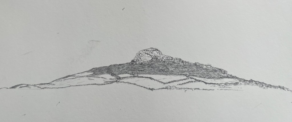
Day four of five in the far south-west of Wales. I had been staying for three nights in St David’s, an international attraction for walkers, pilgrims and casual visitors to its ancient Cathedral. Givin its popularity I had reluctantly paid a small fortune for the privilege of a bed in the cheapest room left in town – a Premier Inn. The weather had been just about as bad as it could have been for the time of year, with the almost relentless rain gusting in at speed from the Atlantic being some sort of revenge for the relentlessly hot, dry summer. On opening the blackout curtains and peering out through the three-inch-thick double glazing, the sky was blue, and early sunshine bathed a distant hill beyond the rugby posts on the nearby recreation ground.
Carn Llidi Tor from the Premier Inn St David’s – weather conditions indeterminate
The previous evening, after being unsuccessful in getting a seat at either of the two snug olde-wordle looking pubs, I retreated to an alternative in a back street to have a quick pint before returning to the hotel. As I sat nursing a freezing cold drink that called itself a “bitter” a middle-aged American couple entered the empty saloon bar, where they stood for a minute or so. The woman who had served me was yacking away with punters in the public bar. It struck me that it might not have been the sort of place the couple were expecting, but if you’ve come 3000 miles on a pilgrimage, needs must. “We’re trying to book in,” the man said to the woman, after she eventually emerged from the public bar to cater to them.
After checking in and receiving the keys the couple went upstairs, at which point the woman who had served them slipped back into the public bar and proceeded to mock the man’s use of English. ‘” We’re trying to book in”, he says. “We’re trying to book in!” What does he mean, we’re trying to book in?”’ There was some laughter from the locals. I proceeded to carry on reading my old paperback. Ten minutes later the man came back into the bar. The woman went over to him. His wife, he explained, had noticed black mould around the shower. Was this normal and could be cleaned off? At this, instead of expressing empathy to her “guest” who, given he was from the States, may never have seen classic British bathroom black mould, the woman started a long, possibly rehearsed, load of nonsense about the rooms being cleaned down thoroughly every day and that no matter what they did it was impossible to remove. In an almost absurd escalation in the excuse stakes she then went on to explain that they could renew the putty every week, but the mould would be back the next day. That she had used the word “putty” nearly had me snorting into my beer, but apart from that it was an appalling example of how to overwhelm your victim (sorry – guest) through bluster, misinformation and subtle sarcasm. Distracted by this interaction I had stopped reading my book – ironically The Quiet American. The poor man had no effective retaliation in his armoury. Somewhat humiliated, and in the knowledge that he was going to have to go back and explain all this to his disappointed partner, he merely mumbled that “he guessed that was all that could be done then” and retreated sadly towards the stairs, head down. The quiet American alright!
I may have stayed for a second pint, but I didn’t. As soon as the man had disappeared upstairs, I could hear the woman in the other bar repeating almost word for word to the other customers what she had told him. There was some more laughter. I supped up and left. *
The reason I mention this is that the next day, and halfway up Foel Cwmcerwyn (the highest point in Pembrokeshire) I kept thinking about it, every so often shaking my head and wondering about the state of things, and indeed what she might have said to the other punters about me after I had left. ‘”A pint of bitter, please. Please, what does he mean by please?”’ Too late to worry about it now.
I had left St David’s and headed out of town on the north Pembrokeshire coast road. Past the Blue Lagoon at Abereiddy, the charming little post-industrial village of Porthgain and the pretty village of Trefin. The day before I had given up on any walking ambitions and had stopped the car in Trefin seeking refuge in the Ship Inn for an hour until an almost apocryphal downpour had stopped as quickly as it had started, after which I was at last able to go back the way I had come and finally check out some of the hidden gems.
Above Porthgain
Porthgain – the harbour. The two people on the bench are, like me, trying to work out how the car is going to exit. On the horizon the Fishguard the Rosslare ferry battles against the elements
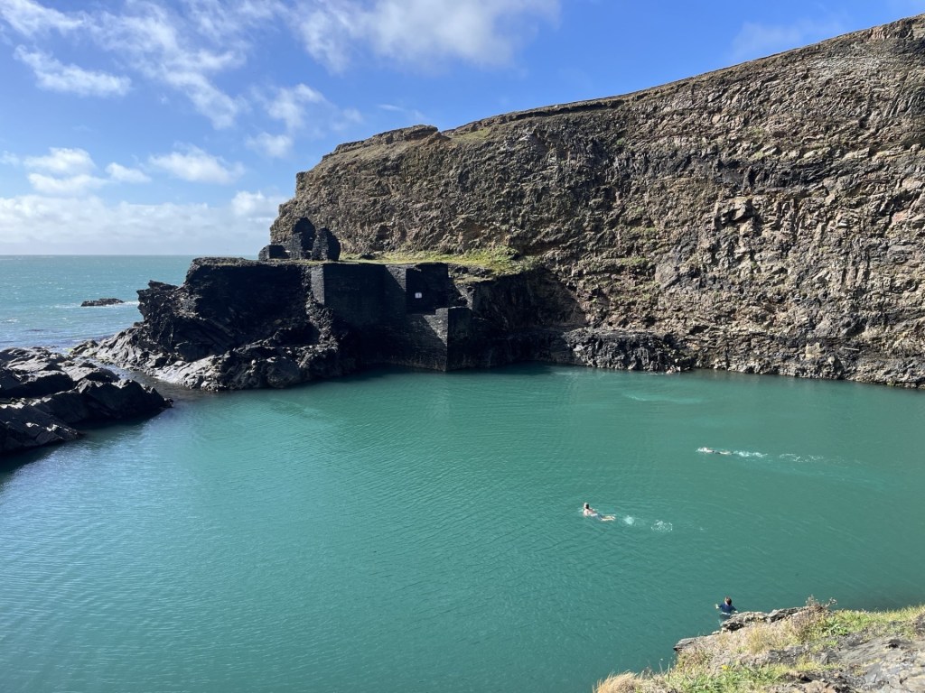
The Blue Lagoon.I wasn’t tempted
Beyond the Blue Lagoon at Abereiddy
Despite almost persistent rain and gale force winds over the previous two days (these photos deceive), I had managed to squeeze in some short walks along parts of the coastal path. Bracing, soaking but also delightful, with huge Atlantic waves smashing into the igneous and sandstone ramparts defending the rolling hinterland, it was a place that screamed “come back.”
With one night left in Wales, the evening before I had booked a room in Cardigan, situated to the north. Foel Cwmcerwyn was, with a bit of a diversion, on route and in the heart of the Preseli hills of Stonehenge fame (arguably). I reached Fishguard midmorning. The weather forecast was ambiguous, but for the moment it was warm, windy and bright and I decided to stop and find somewhere to eat. I can’t tell you about the initial attempt to park in a pay by phone car park because it’s too painful to recount, but if you want to get close to how I felt I can recommend reading my related accounts of similar experiences with the same service provider in West Sussex and Oxfordshire. Needless to say, it was hideous in extremis. After a brief interaction with a local man who recognising my unstable condition and gave me some profound words of advice, I gave up. Minutes later I discovered an entirely free car park just a few metres further down the bay.
Fishguard – Gateway to the Republic, and the EU, from the free car park
Tempting as it was to stay a while and look out into the bay for the chance of spotting the odd seal pop its head above the surface, I had to crack on. I left Fishguard on the A4313 heading inland and east through picturesque country. I reached the village of Rosebush at around 2pm and found a small car park just past the old railway station (more later).
To reach the top of Foel Cwmcerwyn I had to work my way up to the north-east. I had a rough idea of my route but after an abortive meander north along the line of the dismantled quarry railway I backtracked to the car park and climbed back into the car. Heavy downpours were visibly operating in the area, and one was threatening now. I knew there was a chance I’d get caught out at some point, but who needed a drowning at the get go? The shower somehow missed Rosebush. Once I was reasonably satisfied that I was in the clear for a bit, I walked up to some cottages and then onto a signed footpath that led steeply up past some farm buildings and then through a large field. **
By the time I had climbed to the top of the field, I was, to put it mildly, knackered. It wasn’t a good start, but I figured I’d got the tough bit out of the way, and now on a more significant track with impressive views opening up in every direction, my motivation returned.
On track, after the initial lung buster. Looking down on Rosebush
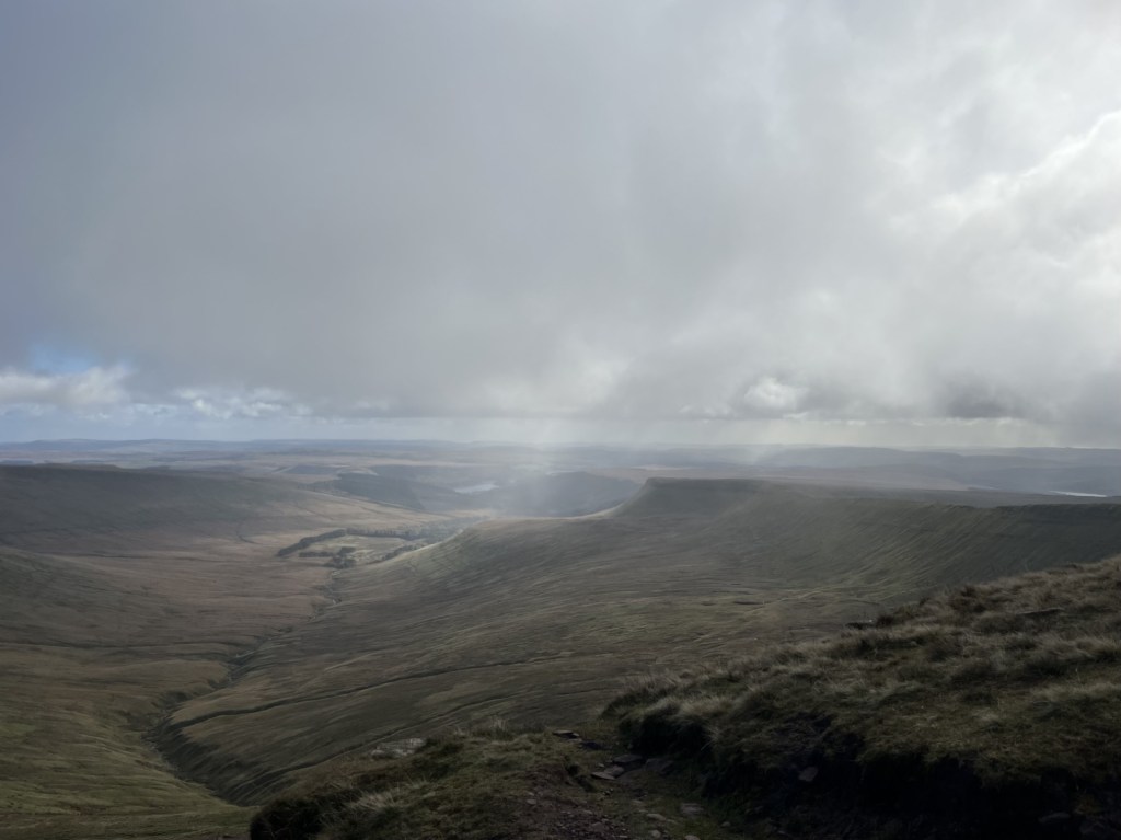
I’ve already mentioned that the weather forecast was ambiguous, by which I mean that it predicted a lot of rain at any moment and very strong winds. I had come fairly well prepared, but now in hot sunshine, and walking resolutely up the well-trod track, I was beginning to wonder if I had overdone it. Looking south a vast battleship grey cloud shedding its load was engulfing a large industrial structure (presumably Milford Haven) dozens of miles away. Already the views were impressive, but so too were the weather systems steaming in from the Atlantic.
The track maintained a steady course heading north-east and on a reasonably tolerable gradient. Soon forestry plantations appeared on the left, and sweeping views opened up down the lush valley to the right.
Towards the forest
Towards the rest of South Wales and storm alley.
Up until this point I had been the only person on the path, but now, coming down in my direction, a couple appeared on mountain bikes. They stopped and we spoke for a bit. Like me they were from the South-East, although a decade or two younger. The man was on a bike fitted with a battery, although I wasn’t so sure the woman was. We talked a bit about cycling (me admitting I was running out of enthusiasm), and by the time we had said our farewells, I was pretty much sold on the idea of battery power. We’ll see.
I carried on across boggy ground before more trees appeared to the left, and the gradient started to increase again. Beyond the trees the wind suddenly hit me like a brick. I made it to a wooden gate which would take me onto the open hillside. Here the path steepened significantly (the cyclists had warned me although I’d been sceptical). Now tip toeing up, the wind battered me from behind, bizarrely hindering rather than assisting progress. It took about ten minutes to wearily trapeze the final couple of hundred metres to the trig point at the top. I knew it was going to be there, and with each step I relished the prospect of being able to hunker down behind it to give some respite from the gale.
So, on arrival, and finding a group of four other intrepids completely surrounding the concrete structure, my little heart sank. All I could do was loiter around for a bit in the hope they would move on, although that didn’t seem likely given their insatiable need for selfies and group photos (I didn’t begrudge them doing it, given it was an achievement worth recording, but I was a good three decades older and feeling like I’d been sandblasted). Thankfully, after some minutes, they departed in the direction of Rosebush, and I was at last able to grab hold of the trig point and stabilise my condition. The views in all directions were magnificent. Here, at the top of Foel Cwmcerwyn I could see the whole of Pembrokeshire and beyond to Cardigan Bay. To the far west the Rosslare ferry was slipping out of the safety of Fishguard harbour and smashing itself directly into the wild wind and waves of the Irish Sea. Now able to stand reasonably steady I took a few photos that probably don’t do the view justice.
A wild westerly and the resolute Trig
Rainbow over Cardigan Bay
So far, I had been lucky. Rain clouds were dotted around in every direction. It was time to head back. Launching down the path was like trying to walk into a wind tunnel. Without gravity I’d never have made it down to the gate. Beyond the gate the trees once again gave cover, and I was proceeding at a reasonable pace. Now more relaxed I was able to get a better appreciation of the views down the valley and beyond towards south Wales proper.
Towards south-westPembrokeshire
I stopped for a bit to take in the dramatic view. A farmer on a quad bike was heading up the slopes and corralling a long line of white dots from one field to another. The commotion had spooked three horses that were now galloping away under sun and shadow.
Cantering on the range
By the time I reached the end of the plantations to my right, I was becoming increasingly concerned by a large looming mass of dark cloud scudding towards my position, and with my name on it. I had nearly caught up with the gang of four who had earlier been hovering back at the trig point. A footpath led west along the edge of the forest. There were two options. Take the path under some tree cover or continue down across the large and exposed field above Pant Mawr farm. I chose the path with the trees. The others chose the field.
Large drops of rain began to fall. Sadly, the isolated tree cover was less than useless so I was forced into a light jog until, on the slopes above the old quarry, I found a large well leafed tree that offered more protection from what was by now an epic deluge. Fortuitously I had packed a small umbrella, which was deployed to surprisingly good effect.
Unaccountably well prepared
The lashing quickly passed, and I headed on down the lumpy and sodden ground to the route of the old quarry access road and railway line.
Slate heaps after the rain
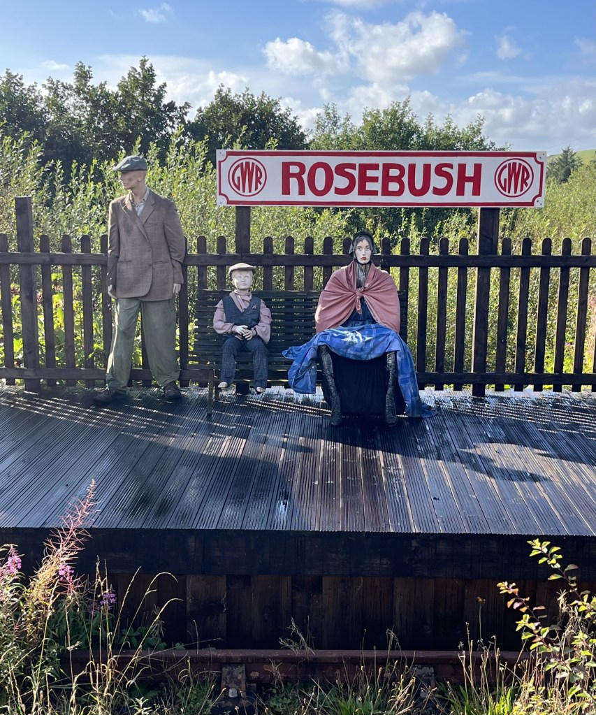
By the time I reached the community run pub at the old station (Tafarn Sinc) I’d walked exactly four miles. Along with the wind and rain it had felt a lot longer but had been worth every step. I’d found a part of Wales off the beaten track, but with a great walk leading to impressive views of the south-west and Pembrokeshire .
I took my coffee out to the open terrace. A small garden area led to where the tracks had once been, and beyond the remains (or possible recreation) of a platform. Three plastic dummies, dressed in period working-class clothing had been assembled, presumably to remind us how it must have been for passengers back in the day. The intense and distant stare on the face of the woman suggested it had been thoroughly miserable, yet despite the passage of time, relative prosperity and different clothes, that look is still familiar on most station platforms today.
A distant echo
As I drove away from Rosebush and towards Cardigan, with the wind still whipping around the nearby trees, the news on the radio announced the end of a political storm that had been brewing away for days across the Atlantic. Peter Mandelson had been sacked.
* I ought to own up here. Whilst I really was appalled by the bar woman’s behaviour towards her American guests, a few weeks earlier I had met up with a very old friend in a small town in the Peloponnese. I was staying in the town, and he was passing through in his camper van. As we sat outside a taverna waiting for food and observing a mink casually saunter up the road on the prowl for anything that moved, I mentioned the sequence of wildlife sounds that had been routinely waking me up in my room every morning. Starting with a crescendo of sparrow chirping around six, followed minutes after that by the sound of a mouse running backwards and forwards in the ceiling space above my bed (it might have been a rat, but I wasn’t prepared to countenance that possibility), and then finally the cicada’s early morning conversations.
The mention of the mouse took my friend back fifty years to a distant moment in time when he had worked at the Waldorf Hotel in London in the mid-1970s. He explained that for a time he had been the night manager and that the worst part of that role was the almost nightly complaints from new American guests about the sound of mice in their room. My friend is one of the funniest people I have ever known, so it was no great surprise that over the next ten minutes he rolled out a long list of all the excuses that the night manager was expected to respond with under these circumstances, and that by the end I was on the floor in hysterics. Without going into specifics, the essential aim was to express immediate and incomprehensible dismay (“A mouse sir! Surely you’re mistaken.”), that the possibility of a mouse in the Waldorf was an impossibility in modern 1970s Britain, that perhaps sirs wife had oversensitive hearing, or that they may have been confused by another source of the noise, or even whether it might have been possible that the guests had brought the mouse into the hotel in their hand baggage. Only in the last resort would a room change be agreed. Of course, it was the 1970s, and not just the Waldorf, but almost every structure in the whole of London was riddled with mice.
** Not visible at ground level, but when I looked at the area around Rosebush on Google earth, I noticed what appeared to be huge letters spelling the word CAWS in the tree plantation just to the east of the cottages. Surely my eyes were deceived. Well, a bit of research and sure enough, around twenty years ago the local farm, which produces its own cheese, planted a large number of conifers that do indeed spell CAWS, which apparently is the Welsh for “cheese”. Smile! Here’s a free ad for them.
A beautiful Spring morning in Bristol, and a few hours to spare with my daughter and her partner J, before heading south after a short but very enjoyable weekend visit. They were both aware of my growing interest in seeking out county high points and indeed had previously enabled me to the tops of Ben Nevis and Snowdon. Was there somewhere locally where a short walk could take us to another county top? Well, up until a few weeks earlier I would have said no, and time was too short to hop over to south Wales. But that was before I had discovered a new county (or so I thought).
In October 2024, when I had climbed Cleeve Hill, I thought I had ticked off Gloucestershire. As winter came and held me in the grip of my local area, I found a map of British Counties online and ordered it. When it arrived it was exactly what I had in mind. Very simple, with the key information, and massive. I bought a large piece of plywood and carefully mounted the map using double sided tape. Now, all I had to do was work out a methodology of categorising the high points (by height obviously, but also by geology, for no other reason than to complicate the process), and then begin to annotate it as and when a new cresting occurred. I should say at this stage that it’s become quite a complex beast, and I’m a while away from any annotation, but something happened a few weeks ago that radically altered the dynamic.
One of the joys of having a huge, mounted map is that it’s easy to look at and take in geographical relationships and direction. When it comes to looking at maps on my phone, or on a PC, my spatial/visual awareness seems to go out of the window. I guess I was just born too late but give me a map in the hand and by and large I feel like I am in control. Of course, I couldn’t fit this map into my hand, but when I was planning the weekend in Bristol I had sat down and looked at the big one to see what counties might provide opportunity, either on the way there, or on the way back. It all seemed straight forward, until err… until, just past Wiltshire (yet to do), appeared a county called South Gloucestershire. What the what the?
South Gloucestershire wasn’t on my original list of counties, but sure enough it exists, as a Unitary Authority since 1996, and after the abolition of the previous authority of Avon. Whether or not including it in the itinerary is open to debate, but it was on my map and delivers all the services provided by Gloucestershire council to the north. It couldn’t be ignored and given that its high point was just a few miles to the east of Bristol, I offered up Hanging Hill as a short walk option before parting company.
We drove out of Bristol on the A431 (Bath Road), and just before the Swan Inn at Swineford turned left and along a track through a farm, pulling up at a small, very serviceable and free, car park set in a thicket of trees. You don’t get many of these for the pound these days, but without the need to have a ten minute confrontation with a pay by phone pay and display machine, I wasn’t complaining. J had done the research, and we set off east, past an old mill stream, and then into a large field with what appeared to be free range ostriches in the one adjacent.
Passing through a line of trees we entered another field, with the path then rising steeply until reaching another tree grouping flanking an ancient drover’s lane. The track, with steep banks on either side, continued up, but without being obvious, started taking us southeast, and away from our objective.
Steeply hollow
After plodding on up for nearly half a mile a path leading away from the track appeared to our left. Following a straight path we entered the seemingly exclusive hamlet of North Stoke. A road continued taking us east. A small red-letter box set into an impressive stone wall forming part of one of the more impressive buildings gave rustic charm. Continuing on and then left again past the modest but aesthetically pleasing St Martin’s church, we started to ascend another steep track that formed part of the Cotswold Way.
I should just say that, having stripped off various layers, and now down to my T-shirt, I hadn’t expected to still be climbing UP at this stage! I hadn’t really been paying much attention to the route and had assumed that we had parked quite close to Hanging Hill. I made my first inquiry whilst panting at each weary step. “Are we nearly there yet J….?”
Reassuring noises came back. Suitably reassured, I found a new lease and before too long (at least another half mile!) we reached a bench next to a gate leading onto a golf course. We were now on the Cotswold Way and that meant more walkers. A shame for me as out of nowhere an enthusiastic group appeared and colonised the very bench that, as we had approached, I had coveted over the previous two minutes.
We stopped, standing, to get our breath back (well, that’s what I was doing at any rate) and took in the impressive panorama looking west and towards Bristol, the Severn, and the Welsh mountains beyond. From the lie of the land, I assumed that we weren’t too far. “Are we nearly there yet J….?”
J consulted his phone. “Yup,” he replied. “That’s it just over there.”
Of course it was…
I looked north. The land fell away steeply into a valley and then rose again towards a clump of trees at the end of a ridge. Just over there, yup, about a mile just over there (as the crow flies). Now, I had all day, but it was a Sunday, and I hadn’t wanted to eat into too much of my hosts remaining hours before their new working week. If, at that moment someone had said that getting to Hanging Hill was going to take too long, I would have surrendered the task there and then, to return another day. But nothing was said and so we continued on, flanking a pleasant looking golf course to the right and woods to the left. At least now we were on the flat.
Just past an old farm building, in a fallow field, a collection of metal fantasy sculptures had been let out to rust slowly in the elements. I’m not necessarily a fan of “industrial” art, which I find somewhat contrived (I can’t find an emoji of Morrissey, but if one exists, insert here), but on this occasion I was suitably impressed. Something about the location perhaps, but also the aesthetic and the way the Grim Reaper with dog, and other Tolkienesque characters had been positioned pulled me in. I considered taking a closer look, but time was pressing, and the need was to move on.
Sculptures by David Michael Morse – Deceased
The track continued up to a crest, with the golf greens now on our left. We headed northwest, still on the Cotswold Way. A delightful wood, covered in a carpet of thousands of wood anemones stretched out to our right. A suggestion to wander through these woods was vetoed. We appeared to be at the limit of our time window. The greens we passed seemed to stretch forever, and judging by the disastrous tee-shot swing (and hope) by a possibly hungover weekend golfer at the nearby tee, his game was going to be a stretch too, far.
Here the course ended and just ahead a gate beckoned us into a large field that vanished to the horizon, which was dispiritingly far away. By now there was a palpable tension. I’ll leave out the details, but entertaining the old man’s cranky new hobby had clearly run its course, and I had run out of credits. We had come too far to turn back. My own assessment of the land and the area suggested that we could make a dash back to the cars an alternative way, but for the moment it was important that I focused solely on apologising with conviction for my selfishness and trust for the best!
We crossed over the large field, a path clearly pointing us towards our destination. Minutes later, and to my overwhelming relief, we reached the trig point that marked the top of Hanging Hill. I was tempted to say we didn’t hang around, but sensibly we stopped and took a five-minute break. Hanging Hill? No idea. The next one to the north was called Freezing Hill. You get the medieval idea here.
Just hanging around. Trig points are handy things to rest on.
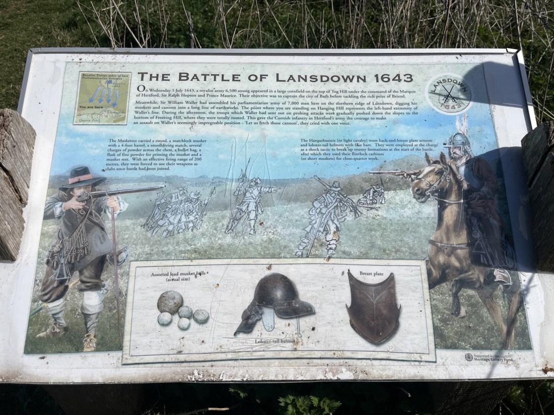
Just past the trig point, an information panel told us a bit about the Civil War battle of Lansdown, fought on this spot in 1643. With time pressing I chose to take a photo and read it later.
Limited information
This is not a history lesson, and in truth, as I found out later, neither was the information panel. * If we had had more time, it might have been possible to survey the scene and appreciate more the scale of the carnage that had occurred here four hundred years earlier. But the research would have to wait.
The killing field
The prerogative now was to get back to the cars as sharp and as shipshape as possible. We’d been out too long. The good news was that it looked like it was going to be all downhill from now on. Except we chose to set off northwest, heading away from where the escape vehicles were parked up. We trod carefully down a steep track through dense woodland, with the first signs of new growth all around. With continuing murmurings of discontent amongst some of the team, I quietly hoped the correct decision had been made. The track continued for, in my mind, too long, but eventually we spilled out onto a narrow road, and despite some hesitation decided to bear left and head west.
Marshfield Lane proved to be the win bonus of the day. Hardly a vehicle passed us, and progress was swift. A bank to one side of the road stretched for some distance, covered by hundreds of yellow primroses. Soon after we were passing the rather appealing looking Upton Arms in Upton Cheyney. No time though to contemplate the achievement over a coffee or cold drink. Onwards and downwards on Brewery Hill and then, at a sharp bend in the road, we followed the footpath directly down through a farm, then through a gate, and within minutes we were sitting in the garden of the Swan Inn at Swineford, the sun beating down and all was right with the world.
Mothers Day at The Swan Inn Swineford
It had been a longer hike than anticipated, with an unexpected, almost continuous 700 feet of elevation from the start to Hanging Hill, and much tougher than expected. Just under five miles, but thoroughly worth it, and in the end we were all still friends.
* The battle of Lansdown hill makes for an interesting read. Not that you would necessarily have known it from the information board, which gave the impression that the Royalist forces inflicted a crushing defeat on the Parliamentarians (under the leadership of Sir William Waller). The forces appear to have been pretty evenly matched, with Waller’s troops dug in at the top of the ridge, his left flank at the trig point. A fuller account is provided in the link below, but in a nutshell, it was a long and hard-fought battle over many hours and into the night. With ammunition low, Waller chose to retreat to Bath in the dark of night. With ammunition low but having sustained severe casualties (not least to many of the commanding officers), the Royalist forces gave up the chase and set off to Oxford in disarray. It had been but a pyrrhic victory for the Royalists. The two sides met again for a rematch a week or so later at Devizes, where the Parliamentary forces were soundly beaten after Royalist reinforcements arrived in the nick of time. The losses at Lansdown Hill are speculation but the estimate is that on the Parliamentarian side, 20 troops died, and 60 were wounded. Multiply both those figures by ten to get an idea of the scale of the losses on the Royalist side, not to mention the high casualty rate amongst its senior officers (Wikipedia). It must have been a brutal and bloody affair, with deadly skirmishes taking place between infantry and cavalry in the woods that we had walked down through. Sobering indeed.
After I read the fuller account of the battle, I was able to picture vividly what the calvary and infantry clashes in the woods above Marshfield Lane must have been like. Loud, close and very bloody. This very rarely happens to me at any historic battlefields, where it is impossible to imagine mass slaughter in a vast corn field. I also realised that, other than a superficial understanding of the English Civil War, I really knew nothing about it at all. Given not just the struggle, but also the fundamental principles involved and how it changed the world, within the week I had bought The British Civil War – Trevor Royle. With 900 pages I may come to regret the purchase, but without seeking out the highest point of this unitary authority, my ignorance would remain complete.
Date/s: 1972? 2001? 16th May 2019 and 6th March 2022
Trains, Planes and Cafe Culture – One from the Vaults
Where do you start with Snowdon? Well, Llanberis generally, but other routes are available.
In the autumn of 1978, I was in my last year at a red brick University in the East Midlands, studying Geography. I lived in a small purpose-built room, in a purpose-built block, with nine other, not fit for purpose young male adults, a shared kitchen and bathroom, and the sound of punk and new wave painting the backdrop. In the third year an intake of new students had included a young man who I’ll call Dom. Everyone had hobbies of some sort, predominantly football and drinking as it happened, but Dom was a bit of an exception. Whilst unremarkable in many respects he was a fanatical rock climber. More worryingly he was also the only person still playing Tubular Bells, on repeat.
Often was the time when we’d return after a few pints in the cheapest bars in town and begin to climb the concrete staircase, only to be freaked out by Dom hanging directly over us as he shimmied up the walls in full kit. All outstretched limbs and magnetic rubber soled shoes.
The winter of 1978/9 was one of the coldest in my lifetime. At the end of November, a wickedly cold period of snow, and then brutally low temperatures, embalmed the east of England in ice. A long-standing overflow pipe that wept water from the top floor led to a build-up of solid ice down the side of the block. Dom, never slow to miss an opportunity, laid his hands on a hose which, by running a slow trickle of water down the outside of the building, slowly increased the volume of frozen water to create an ice wall he planned to hone his ice axe skills on. Someone studying engineering eventually intervened, after assessing that if his artificial ice slope was to reach the required thickness for his ice pick, there was every probability of the house collapsing first.
Most weekends Dom would disappear with his friends to practise his art in nature. I don’t think any of us were ever told where he was going, and to be honest I don’t think we particularly cared, but he was always back on Sunday evenings. So, when one Sunday afternoon there was a knock at the front door, and whoever answered it was met by a journalist from the local newspaper and asking if Dom lived at the address, our curiosity was peaked. On being told that he did, but that he was not at home, the journalist was less than forthcoming and advised that we might want to watch the early evening news.
And, sure enough, on the regional early evening news that night, all was revealed. A search had been going on all day for a couple of climbers who had gone missing on a massive cliff below the top of Snowdon. I think we were somewhat concerned.
Some hours later, and late in the evening, Dom suddenly appeared in the kitchen. Consternation all round, but it was water off Dom’s back. What was all the fuss about? The day before he and a mate had made a start on one of the almost vertical 300 metre cliffs rising above one of the small tarns below. At some point in the late afternoon, and a long way up, a rope had failed, and he and the other climber had fallen a long way before being left to dangle on what was left of the rope, some distance above the base of the cliff.
The night had drawn in, and then the realisation that there was no prospect of a rescue in the dark. The agreed solution was for one of them (I can’t remember who) to cut their rope and then climb down without any safety equipment to get help. Somehow or other this all panned out and early the next day the other climber was safely down, and they set off home. When Dom found out that the nations paparazzi had been trying to hunt him down, he was completely perplexed, finished his cup of tea and then went to bed (after a few finger pull ups from the second floor gutter for good measure).
I have no such stories to tell, but I have climbed Snowdon in the more traditional manner, three or four times. My first visit to the top of Snowdon had taken place just six years before Dom’s adventure, on a summer trip in north Wales with family. I would have been 14, and yet to discover the interesting effects of alcohol, or the rarefied atmosphere of a provincial University and its less than bohemian, yet delightfully diverse community. My memories are slim, but one thing is for certain, we didn’t climb up. We took the train, had some snacks in the old cafe and then walked back down. Given that this was the first proper mountain I had been up, I may well have been left with a somewhat distorted understanding of what they offered. A train, a cafe and stunning views. All very Bavarian.
I have what could be a phantom memory of climbing Snowdon many years after being at university, but for the life I can’t place it. I did spend some days in north Wales in early September 2001, and it could have been then. A day or so after, and having returned to London, I was ironing the afternoon away and contemplating the horrors of returning to work the following day. With the tele muted in the background, for no reason I can think of, I glanced up and watched as what appeared to be a plane smashed into what looked like one of the towers of the World Trade Centre. Thinking it was some weird afternoon disaster movie being shown on some dodgy TV channel I paid it no attention and got on with the job at hand. Looking up again some minutes later, it began to occur to me that all was not what it seemed, and I turned the volume up. Once the full enormity of what was happening had sunk in, I stopped ironing. So, it is entirely possible that at that moment, as I urgently collected the kids from their respective schools, any memory of climbing Snowdon a couple of days before was banished forever.
Some years later, and with more freedom now that the kids had become more independent, I started to visit north Wales more often, either staying in Barmouth or Aberystwyth. There was always enough nature to keep me interested in and around these towns. However, in May 2019, I needed a major distraction whilst waiting on the outcome of the final mind bogglingly expensive and tortuous days of negotiations by a solicitor to buy the freehold of my, and my neighbours flat from a rogue freeholder (a distorted legal legacy from our feudal past). I slipped up to Aberystwyth and decided to take the hike. Anything to block out the never-ending flow of increasingly negative emails.
Driving up from Aberystwyth and through Blaenau Ffestiniog I was flabbergasted by the scale of the slate quarrying that had taken place over the centuries. If I hadn’t already had an objective in mind I would have stopped and spent the day exploring the area.
I arrived at Llanberis and parked up. It all felt reasonably familiar to me, hence why I am pretty sure I had climbed it sometime between 1972 and 2019. It didn’t seem to be particularly busy, but there was one minor problem. Over the previous day or two I had developed a slightly debilitating pain in my right leg, between my knee and hip. This wasn’t a new issue and seemed to flare up from time to time, most commonly at precisely the wrong time. A year or two earlier I had set off on a spritely jaunt from Barmouth up the south bank of Afon Mawddach to Penmaenpool, but on the way back down the river, on the road to the north, my leg had seized up so painfully it took me nearly an hour to drag the throbbing knee gristle over the last half mile into town. At the time I genuinely thought my walking days were over, but the body’s ability to recover is a funny thing.
Whilst I wasn’t going to let a bit of late morning leg pain put me off my plans, I was nevertheless just a tad mindful that if I had a repeat of the Barmouth debacle anywhere beyond halfway up the mountain, I might not have the resolve to make it back down. But, no worries, there was always an alternative if such would occur, and I went to make enquiries in the visitors’ centre.
“Oh no dear, I don’t think that could be done, unless of course you book in advance.”
“OK. So, just to be on the safe side, could I buy a ticket back down for later?” I was at the old ticket office at Snowdon Railway Station, and had enquired as to whether, should I become disabled somewhere up the mountain, it might be possible to hop on a returning train.
“Well, you can try of course, but you have to do it online.” That’s the sort of message that instantaneously causes me to go into a state of deep anxiety, along with an instant resentment towards the modern world. Nevertheless, if that was what needed to be done….
“Ok. What’s the website please?”
“Actually luv, you’ll probably be wasting your time. We’re so busy these days that you need to book months in advance.”
Deflated, but grateful for the fact that the heads-up had quashed further unnecessary mobile phone induced internet curiosity and anxiety, I looked around the large shop, cafe and waiting room, and at the swathes of people holding walking sticks, crutches, or propped up by walking frames. It was obvious that the assistant was right. This was no place for the slightly enfeebled young at heart to be seen lurking.
I seemed to instinctively know where to go (which again suggests another visit within modern history). Leaving the station I walked down Rhes Fictoria (needs no translation) and then started on the small road up through trees on the Llanberis Path. Again, it all felt very familiar, not least because I was reminded that the first half kilometre is a complete pig of a climb, so steep I was almost walking on tiptoes. As I rounded a bend, at a pace that if maintained would see me arriving at the summit sometime the following week, a poseur on a mountain bike slowly passed me by. We didn’t exchange greetings, on account that neither of us had the energy.
And there, around the bend, just fifty metres on, was a cafe! I’d only been walking for ten minutes but the call of bun and coffee was too much. By now, in the crawling position, it still took me a while to get there. It was a busy little hub of activity, and there was just a suspicion that many of the customers had set off with good intentions but had surrendered at the first hurdle. I too came close, but that would have been shameful.
So, on I went, continuing up the road until eventually turning left onto the path that headed southeast and gradually up. After a while, and looking towards the east, the sight of the gargantuan Dinorwig Slate quarry, rising hundreds of feet above Llyn Peris, a moraine blocked lake formed after the last ice-age, was breathtaking. Despite the utter devastation inflicted over two-hundred years by the roof hungry world on Snowdon’s neighbouring mountain, what should be an assault on the eyes somehow gets away with it. Not unlike a northern hemisphere version of Machu Picchu it once served a purpose, and now nature is slowly reclaiming the land. **
Continuing up, the slopes rose to the east and slowly obscured the views towards the quarry, but a slight distance down the slope to the right, the narrow gauge vernacular railway track, that shadowed the path for most of the rest of the climb, made itself apparent when one of the trains (that I would be banned from riding on should I stumble and fall) cranked past and up.
The climb was steady, only really problematic in places where it was necessary to stretch the limbs at low step features. The route worked up the valley with increasingly impressive views opening to the south and west. After three or four kilometres, and quite unexpectedly, another refreshment opportunity presented itself at a small snack shack. It hadn’t been in the plan but any excuse. It had turned into a warm day, so sugar, salt and liquid refreshment was becoming essential. In any case, a break to take in the view sitting on my backside, rather than on the hoof, was very welcome.
After this point the angle of ascent began to steepen as the path swung to the east and on a more direct route up the valley slope. As the climb became a harder challenge, the reward was the increasingly pleasing views to the southwest, and the mystical slate blue, occasionally trout brown, waters of Llyn Du’r Arddu, a glacial tarn that sits on a plateau beneath the soaring cliffs that form the north face under the final ascent.
Llyn Du’r Arddu
The path continued up, hugging the slope, with the tarn on permanent display to the west, and then eventually ducked under a small stone bridge supporting the train line. From this point on the main track was to the east of the line, and the view of the tarn now restricted. Slogging on south, and up, I was beginning to get a sense of height. Surrounding peaks were now to be looked down on, rather than up to. Continuing for another mile or so, the well-worn path presented little in the form of interest, although a particular feature of this zone was the extraordinary number of discarded banana skins (some of which may well become fossils in due course and in millions of years will create great confusion to geologists).
At 1000 metres I suddenly broke cover from the bland slope, at a point where several paths met. Directly to the south was the craggy summit, with a line of human ants picking their way up to, and down from, the peak.
You have to imagine the hoards queuing at the top
To the east the land fell away hundreds of feet, worryingly, but spectacularly down to a beautiful tarn. A hazardous looking path zigzagged dramatically down the steep slopes and cliffs, and I thanked myself for not taking this route at the start of the day (it had crossed my mind as I had passed the busy car park at Pen Y Pass but had instead continued to Llanberis). Looking down the plunging cliff face below the peak, I momentarily thought of Dom, and shuddered.
I can see for miles
This was the point which had made the whole experience worth it. Whilst not quite at the top the views in every direction were dreamlike, and I wondered briefly whether there was much point in carrying on. Of course I did, and with the path following the railway line for the rest of the walk I eventually reached the summit station, and the very modern cafe and visitors centre (the old pre-war café now long demolished).
Not far to the café now
Purchasing a coffee and sandwich in a space not dissimilar to your average motorway service station, but with a better view, I went out and sat on some steps, just taking in the vistas. It was a warm afternoon, but despite the altitude the number of flies and wasps was deeply dispiriting. As far as I could tell, such a gathering could only have been exceeded by Clive James’s outdoor dunny at his childhood home at Kogarah in suburban Sydney. A smell, similar to what you get if you have the bad luck of getting a face full of extractor outside a KFC or McDonald’s (and for the sake of any potential litigation, other big fast food brand frying smells are available) hung over the establishment and had clearly attracted every diptera in the Eryri National Park (sorry, I mean Snowdonia – see footnote). And not just flies. Hundreds of gulls swooped, in the hope of a quick snatch and grab, or just wandered around the perimeter picking off discarded rubbish but studiously ignoring the hundreds of discarded banana skins.
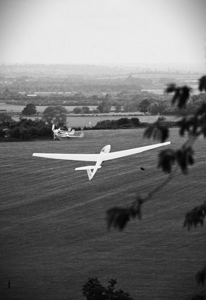
Depressed by the scale of the human footprint just below the peak I took a quick look up. So many people were formed into a line winding up the hundred or so extra feet to the top, I rationalised that I’d done it before at some point and instead started my descent. Not long after, and with nothing particular on my mind, an almighty “whooshing” (old Welsh word) noise to my left, and in almost touching distance, the belly of a glider hurtled from below the ridge and then up sharply before disappearing out of sight. The whole thing lasted just a few seconds but I, and a few other witnesses, stood aghast wondering what on earth had just happened, and grateful that any underlying heart conditions hadn’t been accidentally triggered.
Despite my earlier concern about the durability of my right leg, it thankfully held up to the relentless impact stress on the largely stone stepped path. Relieved that I wasn’t going to have to resort to a dying swan act next to the railway track, I dug in and got on with the retreat. Back the way I’d come, and incident free.
For six or seven hours of the walk I’d put any worries about domestic issue to one side, but back at the car the first thing I did was check my emails. Nada!
The following day, the last of my short stay in north Wales, I drove up the northwest coast and circumnavigated the previously unexplored, and delightful Llyn Peninsula. I stopped at Aberdaron, a small village near the peninsula’s end and walked along the beach. There was no Wi-Fi signal of any sort, which was a curse and blessing in equal measure. Back at the village I grabbed a sandwich and cup of tea in a small cafe. The man serving asked what I’d been up to. I mentioned Snowdon. He knew it well, he said, and then explained he’d been up it numerous times, including three or four times on a bike (one time in snow). I should have been impressed I suppose, but I still had a lot on my mind. I asked him if they had Wi-Fi (the great equaliser). They did, and I took my drink and sandwich to a table outside and logged on.
I had been out of signal range for some hours, but I immediately registered a series of text messages from my neighbour pleading for me to read the emails. By now, and racked with anxiety, I opened Outlook, and the inbox was alight with emails. Judging from the jubilation being expressed in my neighbour’s emails, at long last (the whole process we had reached the end of a painful legal process (which had taken 18 long months – don’t do it unless you really must).
The good news was that we had finally gained the freehold. The bad news was that I was now broke. But the good news was that I could now get on and sell the flat, to address the now being broke situation. The bad news was that I would have to sell the flat. Oh well, as I looked out to sea, I realised that there could have been worse places to celebrate and commiserate at the same time. How many times did the lad say he’d cycled up Snowdon? Well, that was the last time I’d be attempting it either on foot, or by train.
The phone pinged again. An email from our solicitor. “Congratulations, please transfer £X%@&ing1000’s of pounds by close of play!” Wails from Wales!
*
And so, it came as a bit of a shock when, in March 2022, and after two long years of lockdowns, I ended up staying with my daughter and her partner in a small cottage in a valley in the middle of a very rural north Wales, somewhere near Cerrigydrudion. It was so remote that at night, if a car entered the valley two miles away its headlights lit the roads and hedgerows like a 1940’s black and white film noir. I expected a knock on the door and two men in beige gabardine coats demanding to see my identity papers at any moment. The shock was that as part of the deal (it being in part a birthday treat), there was an expectation that a climb up Snowdon was required. “But,” I explained, “I vowed I would never go up Snowdon again.” Of course, and quite rightly, my feeble excuse fell quite literally on stony ground, and so on the morning of the 6th March 2022, I was back at the visitors centre in Llanberis. At least, I rationalised as I looked up to the snow covered peak, if my leg gives in this time, I had two young Sherpas to get me back down.
We set off, and of course I’d forgotten again how gut bustingly steep the first half mile was. The route, of course, was the same as before, and before that and that, and despite the gloriously sunny day it was cold. Maybe it was the time of year, or maybe it was a consequence of Covid, but there was no sign of life at the halfway snack shack. Lynn Du’r Arddu was a challenging slate blue. No signs were necessary, but if there had been they would have said “Swim here – If you think you’re hard enough!” I assumed that the guy from the cafe at Aberdaron had already done it, before climbing up the rest of the mountain on his hands.
The snowfield started at around 900 metres. A light dusting at first but gradually increasing in depth where the ground wasn’t fully exposed to the wind. By 1000 metres, and where the path emerged onto the col at Bwlch Glas, for the first time in my life I was high on a mountain in polar conditions. It was cold but the exhilaration of being at that location, there and then, and with my daughter and her partner blocked out any discomfort. I guess that if there had been the slightest of breezes it would have been a different matter, but we were lucky.
Compare and contrast (Spring 2019 above)
As we took photos and gawped at the magnificent views, I noticed my daughter and partner had started up a conversation with a couple standing nearby. It transpired that they were work colleagues from some time back. About the only time I have ever randomly bumped into an old friend was coming out of the tube at Tufnell Park station, so it seemed almost incredible that this was happening at 3000 feet on a mountain in north Wales; in winter. I was introduced to the couple, who were on their way back down after reaching the summit. I rather pathetically mentioned that at 64, and from what I had seen on the trek, I was almost certainly the oldest person on the mountain. But apparently not. They’d come up with one of their dad’s. He was 70. “Right. Where is he now?” I asked, embarrassed and somewhat deflated. “Oh, we left him at the top.” There was no hint of irony or further explanation. I looked towards the frozen summit. Perhaps, I wondered, it was a discrete form of assisted dying? I am sure I’m not alone in having an older relative say something to the effect that “if I ever end up like that just throw me off a cliff.” When it happened to me a couple of years ago, I had to explain that whilst I understood the sentiment, the consequences for me would be life in prison. However, being left at the top of a freezing mountain without walking aids? Hmmmm…. I haven’t had that conversation with my children…yet!
My daughter is waiting for me to say something. It can wait.
After parting company with the couple we carried on, following the line of the railway track, covered in snow and under maintenance. We reached the cafe, which was also closed. Fortunately, we had some bananas. We sat on the same steps I had sat on three years earlier, admiring the surrounding landscape and untroubled by any flies or the smell of hot fat.
After a short break we joined the queue to the peak (resistance was futile), and not long after we attained the summit, took the obligatory photos and headed back down.
Near summit view towards the sea
I’d kept a careful eye on all the other climbers throughout, and at no stage did I see any man who looked remotely 70 years old. Curious?
Don’t leave me…just yet! We need to talk about it.
Despite my initial misgivings, climbing back up Snowdon in such invigorating conditions, and in good company, was wholly worthwhile. But I’ll never do it again! The kids left the next day, and I spent a couple of extra days staying in Barmouth. Someone had recommended taking a look at Cadair Idris, and despite still sore legs I made my way to Minffordd, a short drive from Barmouth.
I could write another thousand words on my day on Cadair Idris, but that’s not the point of this exercise. At 2930 feet, it’s a long way from even being the second highest peak in Gwynedd, but from a purely aesthetic point of view it is a little gem of a mountain. A challenging walk with glorious examples of every glacial feature that physical geographers dream about (think roche moutonnee’s, but not for too long), and because of its solitary location, breath taking views in all directions, Cadair Idris is far more than worthwhile. A big thank you to the person who recommended it, and don’t tell anyone on Instagram.
Cadair Idris. This view is for free
* Anyone who has had the endurance to read this far will almost certainly be concerned, positively or negatively, that I have stuck with the traditional English name, Snowdon, and not the traditional Welsh name Yr Wyddfa (Snowdon). There is an interesting (if you’re into etymology) discussion to be had as to what came first, and indeed what both these words mean. The English Snowdon is pretty straight forward. Don is “hill” and snow is – well pretty obvious. The first documented use of the Old English Snowdon was recorded in the 11th century – so, pretty old. Yr Wyddfa is a bit more ambiguous, and without walking into a linguistic minefield I have no understanding of, it either means a cairn or burial mound, or a high place. The use of Yr Wyddfa as a name for this place is recorded, but some centuries or two after the English version. Regardless, I have stuck with Snowdon on this occasion for the simple reason that the official name change took place late in 2022, some months after my last ascent.
I am 99% certain I will not be climbing it again, but if I do, and need to update this account, Yr Wyddfa it shall be.
** As I was writing up this account a BBC news story popped up about wanton damage being caused by a large rise in people visiting, and recklessly exploring the Dinorwig Slate quarry. Unfortunately, in the process vandalism and damage was being caused to the historically important industrial heritage site, including buildings being set on fire. Arson aside, I’m not entirely sure where I stand on this. Given the centuries of industrial scale brutalisation on the landscape, trying to preserve its legacy in aspic feels somewhat ironic. No culprits were named, but the main driver had been identified. Instagram!
Despite Warwickshire being almost bang central England, when I came to think about it (other than driving through parts of it, mainly on the M6), I had only ever been there twice. Once, for a day trip nearly forty years ago when visiting Stratford upon Avon and Warwick, and once to visit Coventry in my 50th year (by which time the fair City was no longer in the county).
That said, there was one other occasion, and it lasted about a year. I was born in Coventry in late 1957 but had left the city a few months later. In 1957 Coventry was enjoying a relatively short number of years (132 to be precise) back in Warwickshire, after being banished from the county in 1451, and not re-establishing its presence again until 1842. It was dispatched again, to become part of the West Midlands Combined Authority in 1974, where it remains. Looking at a modern map of Warwickshire it looks like a sea cucumber type creature that’s taken a kick in the stomach, with Coventry being the tip of the boot that’s sticking it in.
If you have been keeping up with this irrelevant preamble, you’ll see that by the respective dates, at the time of my birth, Coventry was in Warwickshire. That makes me a son of the county. Who knew? When I was fifty, I thought it was about time I took a diversion on a journey further north and investigate where I’d spent my first few months. By then of course, it was no longer part of Warwickshire (see above!). I arrived at the large estate to the northeast of the city centre and found the road where I knew the flats were located. Except they had gone. Demolished, presumably, as part of an estate regeneration program. From what I could see of what was left, it was going to take a lot more than a regeneration program, or a visit from Michael Heseltine, to breathe any life back into it. I didn’t get out of the car, and drove on with a sense of outrage and shame. *
But this is not about Coventry. It’s about Ebrington Hill, the highest point in Warwickshire, (located on the boundary with Gloucestershire, to the very southwest of the county), how I got there, and then home.
A week before Christmas, and a couple of months since I’d last topped a county (Oxfordshire and White Horse Hill), and I was getting twitchy. I had a family appointment in Bedfordshire on Wednesday afternoon. Normally I would have made the journey and then driven the three hours plus trip back home. But I didn’t much fancy that prospect. I looked at a map. Where could I get to in an hour or so after my visit that didn’t take me too far from home, and gave me an option on a summit the next day?
It didn’t take too long, and the day before I left, I booked a reasonably priced room in an hotel in Royal Leamington Spa, a place I knew with all certainty that I had never been to before. On the day I arrived just before 8pm, and as quick as a flash had made it into town and sequestered the only remaining seat in the Copper Pot inn, just in time for kick off. Tottenham v Manchester United in the League Cup quarter final. I’m determined to avoid football references as much as possible in these accounts, but for 60 minutes I felt as if I was in a dream after Spurs marched into a three-goal lead, and with no hint whatsoever that United were going to be able to lay a glove on the boys from the Lane. And then, inexplicably, our goalie (good, but old, and not first choice) managed to pass the ball directly to an opposition forward, and it was 3-1. Then, just a couple of minutes later, the same goalie dithered on the ball in his own box, and another opposition forward, half his age, nipped in and slipped the ball into the net to make it 3-2, and suddenly Spurs were on the ropes. My little daytrip treat to myself was now beginning to feel like a monstrous mistake. But then, with just two minutes of the ninety left on the clock, Son Heung-min swung the ball directly into the net from a corner and it was 4-2, and we were safe. The United fans behind me at the bar, who had been urging their team on after the two self-inflicted calamities, were mercifully silenced and the United goalie spent the next two minutes running around after the referee claiming he’d been fouled. It was comically embarrassing. At least the Spurs goalie had just shook his head and taken his shots. With five minutes of extra time United made it 4-3, and despite a final nervous moment Spurs had won and were in the semi-finals. I hadn’t been that happy in years, and on the way back to the hotel popped into a nice local pub where the TV was showing an interview with the droll Spurs antipodean manager. I just sat with my beer giggling.
The next morning, and after a hearty breakfast, I went back into town strolling the Georgian streets and the charming riverside park (even in mid-December), scratching my head and wondering why I had never been to Leamington Spa before. By the time it was time to go I had made a mental note that a visit on a warmer day would not be without reward, but also made a note not to bother revisiting the station, unless I was going to be arriving by train. Art-deco is not generally my thing, but I understand that at the time it was a valid art and design form and has occasionally produced significantly important architecture (think Hoover building at Perivale, or the Carreras Cigarette factory at Mornington Crescent). Whoever was responsible for the brutalist art-deco station in Georgian, Royal Leamington Spa (Percy Emerson Culverhouse to be precise), had clearly come from a splinter faction influenced by certain, in vogue at the time, European dictatorships.
You can’t blame WW2 for this one
I set off from outside the hotel just after 10.30am and straight into a traffic jam that refused to release me for the next half an hour. A tad frustrating, but eventually I was just south of Warwick castle and looking at the map to find my way south to my objective. There were several options, all pretty much the same in terms of time, but the route that would take me along Flat Rabbit Road appealed, I guess for the obvious curiosity factor. Somehow, I must have missed the turn for Flat Rabbit Road, because a while later I was turning right at a roundabout and onto the Fosse Way and hadn’t seen a single flat rabbit.
Taking the Fosse Way (the old Roman road from Lincoln to Exeter) had not been in my route plan but after a few minutes, as the virtually straight road rose and took the high ground, and with fine views across the Midlands, I was overcome by a sense of nostalgia. Forty-six years before, and living in Leicester, a housemate in the student digs I lived in offered to take me for a weekend in Bristol, near to where he lived. We set off in his moss-covered classic green Austin Morris 1000 Traveller, and instead of doing the obvious, taking the M1 and then M4, and probably because the engine was ill-equipped to pass muster, we stuck to the Fosse Way for most of the journey. As I drove on southwest, taking in the vastness of the unfolding views, the original journey was coming back to me in spades. My friend Andy was one of those people who just made life worth living. An intelligent bright spirit, great footballer and full of life, and who was so funny you could be in tears of laughter for hours.
Generally, I loathe driving but fittingly my iPod, as if it was sensing the occasion, started chucking out some bangers. The volume went up and the miles passed by with the likes of the Manics and Jimi Hendrix pounding out the soundtrack. Every so often, red and white signage at the side of the road reminded people that it was a High Risk Crash Route, and came with casualty statistics. It made grim reading, and whilst I was doing my best not to get carried away, and sticking to the speed limits despite the motivational music, I could easily see how less disciplined motorists might find it very tempting to put the pedal to the metal on the Fosse Way.
For three or four years after leaving university I kept in touch with Andy, but eventually the letters stopped, and we went on to have our separate lives. There was nothing particularly odd about that in those days. Decades on, and with the ability to connect to anyone on the planet with the touch of a keypad, occasionally I have tried to search him out, but to no avail. I guess, having a Christian name that at the time would have been one of the most common in the country, and a surname that very much is the most popular in the country, my failure to track down the charming man, has perhaps not been unexpected. I miss him and his company. Thanks for showing me the Fosse Way, Mr Smith.
At Halford the road I’d hoped to take to Armscote was closed. With a bit of guesswork, I found another narrow back road that took me into what appeared to be a very exclusive village. I headed west out of the Armscote and some minutes later arrived in the larger village of Ilmington. I parked up on Grump Street, which overlooked a large green, and checked my bearings. I could see from the directions on the phone app that I was near my destination, but for the moment I took a few seconds to look over the green towards the fine solid buildings, and beyond the stone tiled roofs of the village. Without exception, and despite the overcast conditions, every building, old and new, radiated an exquisite orangey, yellow colour that I assumed to be sandstone. (Nevertheless, and overcome by a sense of curiosity, I later looked at the area on the British Geological Survey’s Geology viewer. Much to my surprise I discovered that this was the start of the Cotswolds, and that the building material in the area was Oolitic limestone). On another day I would have parked up and walked through the village and found a way up to the top of the hill. But rain was in the air, the wind was whipping up and it wasn’t another day.
Driving out of the village and heading west, the road suddenly started a steep climb that continued for about a mile. Instinctively I knew I was heading in the right direction, the direction being up. The bright low midwinter sun of the early morning that had illuminated Leamington Spa, was now a distant memory. The road began to flatten out and large muddy fields opened out on either side. The last remaining leaves were being cleared from their parent branches and being flung at the windscreen. Now driving west on Nebsworth Road I knew I would soon arrive at a small road on the right. Moments later, and about a hundred metres on, a small and immaculate vintage sky-blue tractor pulled out of a turning on the right and started towards me. A contented looking man sat on the open seat. From what I could see the tractor was pulling a small trailer with a couple of bales of hay. I hadn’t seen a quaint rustic sight like this in decades, but one thing was for certain, that turning was my road. I could very easily have missed it if the farmer hadn’t chosen that moment to deliver some hay to his flock.
The land that carried this one-track road appeared to be flat. Hardly the stuff of county peaks, but after a quarter of a mile I recognised Lark Stoke transmitter station on the left-hand side. I had read that the highest point was just nearby. Despite the narrow hedged lane, a verge on the left (and just short of the transmitter entrance), allowed enough room to pull over and park up (remarkably I had noticed this tiny detail when I’d checked out the location on Google). I changed into my boots and stepped out into a gale. For some reason I had imagined that at this moment twenty Disney cartoon red breasted robins would descend chirping merrily from the nearby trees and knowingly escort me to my destination. But, for some reason they didn’t, and I was left to my own devices.
Just opposite the transmitter station (a building that looked like it had another more sinister purpose to that advertised) a signed footpath led me between two fields. I tiptoed through muddy puddles for about a hundred metres until I was certain that the land was beginning to dip away, turned my phone camera into the brutal wind, took a single shot (my eyes were streaming so much I couldn’t be arsed to take a second), and beat the retreat back to the car.
Somewhere around here, I think. Ebrington Hill and a seasonal crop?
I had just enough interest in the moment to have a glance around and took a second photo of the wide-open landscape to the west, where hills cropped up here and there and onto the horizon, before surrendering and falling back into the car. I had had my moment on the Birdlip limestone peak of Mount Ebrington. **
Lark Hill Transmitter – Not the right direction to the top
Whilst I wasn’t entirely sure that I had taken the right path (some posts about this location give the misleading impression that the top of Ebrington Hill is along the track past the transmitter station, near a trig point set in a wall), I was pretty certain that I had been there or thereabouts. I may have missed it by an inch, but it was getting on and I needed to get home.
I didn’t bother changing back into my trainers. Turning the car around and heading back south, some distance down the lane a couple with a dog were sauntering in my direction. As I neared them it was obvious that the road wasn’t wide enough to allow continuous safe passage, so I stopped to let them pass. As they neared it suddenly struck me that being in such a remote setting there would be customs to observe, and it would be rude not to say something (although of course I could have just smiled and nodded). They were virtually by the side of the car when I let the window down. The problem with my plan was that, at just the moment they looked down at me, I hadn’t come up with anything to say other than an awkward “hello.” Whatever the impulse was that had led me into this potentially disastrous course of action was now horribly exposed, but they smiled, and I knew I had to say something more. The problem was that the “something more,” which had suddenly popped into my head, was going to sound so insane that initially I couldn’t spit it out. Nonetheless, I could see they were hanging on, as if waiting for a punchline.
“Ehhmm… err.. I err.. hmmmm,” (I had made an appalling start), “was wondering if that err.. field back there is… errrr… the, hmm….,” (I knew they were now worrying for their personal safety), “maybe the hmmm.. highest point in…. ehhmm…err…. Warwickshire?”
It seemed (from my perspective at least) that the tension was broken, and indeed they both smiled a bit more confidently. “Yes, yes,” the woman said, “just down the path a bit and at the hedge opposite the wireless station.” It was a huge affirmation, which of course I hadn’t really needed, but hey!
To my great relief, and almost certainly as a consequence of being spared further embarrassment, I immediately turned into a chirpy cockney type, gave them a big smile, said that that was great and I could now tick it off my list, and then thanked them profusely. They smiled back sympathetically, giving looks that implied they were asked the same question every other day. I figured that the local neighbourhood watch would be notified regardless (and correctly), and with a little wave set off south.
I should really end this narrative around now with a succinct summary, but I still had to get down South, and home, so I’m afraid there is a little bit more to consume.
I headed off in the general direction of Chipping Campden, but would be veering back east at some point and heading for Banbury, the M40 and then the three-and-a-half-hour journey beyond. It was the Friday before Christmas and the radio was alive with warnings about it being the busiest day on the roads all year. Great!! I hadn’t factored that scenario in at the planning stage.
A mile or so from Ebrington Hill, and on a road that headed downhill, four jays emerged out of the surrounding hedges and flew (knowingly perhaps) in front of the car for a couple of hundred metres. I have never seen more than one jay at any one time, so to have four – well perhaps it was the Disney moment I’d hoped for earlier.
The B4035, that headed east, and would get me across the county to Banbury, was picturesque, even in the bleak midwinter. Villages and small towns that were so rural pretty they looked like they had been built with the sole intention of being photographed for Christmas cards and biscuit tins, came and went. I don’t exactly know where the alleged north/south divide starts and finishes (I think it used to be Watford), or even if it has any real meaning, but judging by the apparent affluence on display in this part of Warwickshire, if this really was north the societal characteristics are being well hidden.
Approaching the outskirts of Banbury I stopped driving and sat in a jam for twenty minutes. Forty minutes later I was slowly squeezed out of Banbury and onto the M40. The forecast of road chaos had been accurate, at least in and around the small market town, and with deep foreboding about what would happen at the M25, I started to head south. After a few minutes I recognised the tell-tale embryonic signs of a migraine, an irritating event that comes out of the blue from time to time. That said, on this occasion I had half an idea why. A long day driving the day before, followed by three pints of the local best in Royal Leamington Spa, and then being woken before 6am by the extraction system from the kitchen in the nursing home opposite my room (surprisingly, not advertised in the on-line blurb promoting the rooms benefits), almost certainly played a part. Knowing how things might pan out, a couple of miles on I pulled into Cherwell service station. An hour, and two rejuvenating strong tea’s later, I had recovered. Somehow, I’d missed a bullet. It could have been a lot worse. If it had, I may have had to abandon further travel and book into the on-site hotel. As I sipped on my tea, eye’s half closed and avoiding bright lights, I thought about the hundred or so migraines I have had over the last two decades. About 50% had been of the mild variety (like the one I was having), and about 50% had left me debilitated for hours. Fortunately, I don’t get the serious headaches that can have a major impact on other people’s lives but trying to explain to anyone what my migraines are like is an almost impossible task. As I thought back on the day it occurred to me that the next time someone asks me what one of my bad one’s is like, I would say that I felt like a flat rabbit.
As I went back to the car I checked emails on my mobile phone. There was one from a delivery company saying they were delivering a package that afternoon, and at a time I knew I wasn’t going to be home in time for. Given that I hardly every order anything on-line it was frustrating. I tried to open a link that said I could give further instructions if I wasn’t going to be home (where was that function when I had ordered it?), but there was insufficient signal so that was that.
I carried on south, feeling okay, but increasingly anxious about the delivery and the prospect of it being dumped outside the door in the pouring rain. With the M25 approaching fast I saw a sign to Beaconsfield services. I still had an hour to influence the delivery, and so pulled in and parked up as far from the main building as possible. This time there was a signal and I managed to open the link. The options were limited (like, where was the option to leave it behind the white Grecian style planter with the eucalyptus bush?), so I nominated a favoured neighbour (and apologised in my head at the same moment). After I was as satisfied as I could be that I had completed the task, I looked up. And there it was! In the parking bay opposite, and in the photo below. Wrong colour, and the driver a different gender, but a ghost from the past, nevertheless.
What, I wondered, were the odds?
Whatever all the fuss was about, the anticipated nightmare on the M25 failed to materialise, and I circumnavigated the south of London faster than I had in years. The migraine aside it had been a very satisfactory 48-hours, and I’d connected another bit of the puzzle. On this occasion to Gloucestershire, Oxfordshire and Worcestershire. The other adjacent counties, Northamptonshire, Leicestershire, Staffordshire, and, it now seemed, West Midlands Combined Authority, would have to wait until next year (or the next, who knows?).
The following day, browsing as you do, an ad popped up. Big Country (the band) were playing Leamington Spa in April 2025. Hmmm…?
* Just three days after writing this piece a news feed popped up on my phone informing me that, for the moment, no decision was going to be taken to merge Warwickshire with the West Midlands Combined Authority. As if that had ever been a thing! But it was, and it is. I’m going to have to check to see if the West Midlands Combined Authority is on my list and where its highest point lies. This is getting trickier.
**The birdlip limestone at Ebrington hill is the same formation that outcrops at Cleeve Hill in Gloucester, which I had been to two months earlier. Without looking this up I would never have made any connection between these two very differing landscapes. It’s a big county indeed.
To my old friend Andy Smith and the spirit of the Fosse Way.
When you stand at the top of Ben Nevis, the nearest higher point, roughly to the northeast, is in Norway. That means that if you manage to climb to this point, and unless you’re standing next to someone taller than you, you are the highest person on this part of the planet for 700 kilometres, in any direction. If you draw a line directly south, the first higher point is near Santander on the coast of northern Spain. If you draw a line directly east, and this is not entirely scientific, the first higher point is an undefined location north of Lake Baikal in Siberia. If you do the same going directly west, and again this is unverified, it’s somewhere in the Rockies in British Columbia, and not a million miles from Dawson’s Creek. Taking this one last step, heading directly north, the 4413 feet elevation height line goes over the North Pole, and I’d like to think all the way across the Pacific Ocean until you reach another undefined point in Antarctica (although it is possible that there might well be higher ground somewhere in the Chukotskiy Khrebet range of mountains in the very northeast of Russia and somewhere south of a tiny settlement with the unlikely name of Billings. *)
Of course this is all entirely academic (just to clarify, no academic research was involved), immaterial and perhaps even meaningless. But though Ben Nevis, compared with much higher, and indeed colossal mountains around the world, is relatively small fry, it represents the highest point on Earth for an astonishingly large part of the planet. Mind you, and for what it’s worth, at Oakwood Station at the northern end of London’s Piccadilly underground line (height 282 feet above sea level and approximately 4200 feet lower than Ben Nevis), there is a sign that reads ‘This station is the highest point in Europe in a direct line west of the Ural Mountains in Russia.’ Which also means that Ya Souvlaki, the Greek restaurant next to the station, is the highest kebab shop in a direct line west of the Urals too.
The first ascent
I first climbed Ben Nevis in the summer of 1993 or 1994. A family holiday at Dunoon, a three-hour drive south, on the banks of the Clyde estuary. It was hot, and the midge count was set at maximum (that’s eleven times eleven million per square cubic metre). With my brother-in-law and our respective sons, both no more than seven years old, we drove north, and eventually, after an excruciatingly long journey, arrived at the car park of the visitor’s centre, where we met up with the brother-in-laws father (who had come over from the east coast and, it transpired, in his role as a teacher, had previously taken many school trips to the top).
The visitors centre lies a mile or so out of Fort William and is not too much higher than sea level. Given that it is the biggest mountain in the British Isles, that means any walk to the top starts at or near sea level. So, you are in for the full slog.
Given the length of the drive, we eventually set off late morning and reached the top some hours later. Despite the mid-summer heat, a north facing gully near the top still retained a healthy layer of snow, which came with a calamity warning about its risks from my brother-in-law’s knowing father. It had been a long, hot day and the kids had been heroic. Despite the elevation and purity of the air, I can remember a slight disappointment in the view. At the summit there were no plunging vistas, just a rock-strewn plateau with the rounded summits of hundreds of similarly sized peaks disappearing in all directions. But hey, a minor detail.
By the time we began the descent it was late afternoon, and shades of guilt began to bite knowing that the two lads had so far to go before a well-deserved Irn Bru and mutton pie.
I would like to share one or two photos of this day, but due to a technical error (owners incompetence), I can’t. The technical error occurred a few hundred feet down from the summit, where, and I can’t remember the exact circumstances, my standard issue Canon instant camera detached itself from either my hand or bag and was last seen bouncing down a scree slope that stretched into eternity. For a moment it felt like a death had occurred. How ridiculous! Nevertheless, it contained real bonafide evidence of an epic day, which years later would have brought happy memories. Of course, children being children, the instant scope for adventure kicked in and they were both over the top and heading down the treacherous slope in pursuit before parental responsibility kicked in and they were brought back under control, and safety. Over the years that moment has come back to me again and again (possibly when risking life threatening dashes over insecure scree slopes), and I wonder if anyone ever found it. Highly unlikely, but I also wonder how long it would have taken before the elements did their worst and killed the film. Maybe not that long. I need to get over it.
The Second Ascent – Journey to Base Camp
Thirty years on, the journey to the visitor’s centre was from an entirely different direction and had taken a good deal longer than anticipated. I had an appointment to meet with my daughter (who would have been no more than two or three at the time of the first ascent) and her partner near Fort William on Friday the 21st of June, with the purpose of riding the steam train across the Glenfinnan viaduct on the Sunday.
Nine days earlier I left the south of England and headed up to Scotland. I had intended to make this trip the previous September to catch up with relatives, but after meticulously booking various hotels going up and back, I caught Covid a few days before and had to abort, losing a shed load of dosh on the bookings in the process.
Being June, and based on previous June encounters with Scotland, the prospect of a few days of nice weather led me to picturesque Stonehaven (on the east coast south of Aberdeen) for a couple of nights, and with the intention of launching north and then west to Achmelvich for a few nights camping on the beach.
On the second washed out day in Stonehaven, and having assessed the weather over the coming days, it was clear that camping anywhere in Scotland was no country for an old man.
And there was no going back opinion. The best of the weather (the distinction between best and worst was entirely marginal and should perhaps read “the best of the worst weather”) seemed to be further north and east. To that end I booked expensive rooms further up the coast. After a night in the previously unknown (to me) town of Tain, by Tuesday I was hunkering down in Thurso. On the journey up I had passed over the historical border of Caithness, now subsumed into the much larger county of Highlands. The road north is almost entirely coastal, but at some point I looked inland and caught a fine glimpse of the very distinctive peak of Morven (Fiona), the highest point in what was once Caithness. I was almost tempted. But it was getting on, the weather was entirely unpredictable, and I had already set my mind on an unexpected shot at John O’Groats. Some things only present themselves once.
I’d booked two nights in Thurso, having had absolutely no intention of ever being there, but it was clearly the least wet part of northern Scotland at that moment in time, and the room was just about affordable. After passing Morven I eventually reached John O’Groats, and in almost horizontal drizzle (that was a first) I walked out of town and made it to the furthest north-eastern point on the mainland – Duncansby Head. An impressive cliff scenescape stretched south, which would have made a fine view had it not disappeared into the mist.
Duncansby Head – An impression
The following day I made it to Dunnet Head, the most northern point on the mainland. Hundreds of nesting seabirds, a couple of puffins after an hour trying to spot one (another first, and probably last), and murky views across the briny to the Old Man of Hoy, Scapa Flow and Orkney.
Spot the puffin
Earlier in the day I’d been tempted to nip over on a ferry, but the sea was excitable, and the prospect of being stranded on Orkney for a couple of days ruled it out. As I was about to leave the Dunnet Head car park I realised I had mislaid my binoculars. I retraced my steps and they’d gone from the spot I had put them down at. They say rural crime is on the rise. They had gone, and in my mind, there were only two potential culprits, but they weren’t fessing up. Humph!
I could have dwelt on this misfortune (I mean, I did of course) but rationalised that having finally spent fifteen minutes observing two puffins through them, they had duly served whatever purpose they had been manufactured for.
Thursday the 20th of June was the longest day, but with the dreich still lingering you wouldn’t have known it. Staying in the northeast was no longer an option. I needed to be at Spean Bridge, near Fort William by Friday, and there was just a hint on the weather app that there was a threat of sun later in the day to the west. I set off along the top, and as time passed the cloud slowly lifted. A long day’s drive, but with empty roads and the increasingly beautiful, glaciated landscape south of Loch Eriboll dazzled this old geographer’s eyes. Time was inconsequential. Everyone should do this trip once (free school trips for all kids in Britain to be made compulsory). By the time I was heading south (having abandoned any loose plan to get to Cape Wrath – the most northwestern point on the mainland, and mainly because it appeared to be almost inaccessible without detailed advanced planning), the sun was breaking through for the first time since I had left home.
At a remote village (that will remain unnamed on the grounds of national security, the possibility of being sued, and the avoidance of it becoming an Instagram “go to” location), a cafe had me calling. After an awkward few minutes, I’d eventually negotiated a tea and something to eat. Whilst we shared a common tongue, the person serving had so little insight as to what she was able to furnish me with that it took me to suggest a cheese roll before the eyes lit up and we were back in business. Sitting on a lump of granite, overlooking a small harbour, I sipped at the milky tea before taking a chunk out of the huge roll, stuffed with grated cheese and some pickle (I had had to suggest the pickle as a topping option).
One bite was more than enough. Without doubt the processed everything was quite simply the worst cheese roll I had ever had to ingest. I was sorely tempted to take it back and seek compensation on the grounds of it being a breach of the Trades Descriptions Act, but sensitive to the precarious nature of any business at the end of nowhere, I decided to swallow my aghast and bin it. I walked back to the car. There was no bin, but a sign passively aggressively instructed me to take my litter home with me. As I continued my journey the super sub sized disappointment sat on the passenger seat, cooking and sweating in its wrapper.
By now the sun was well and truly making an appearance. Glory bloomin’ be. Crossing the bridge at Kylesku, to the southeast the inspirational views of Ben More Assyant (the highest point in the old county of Sutherland), and its neighbouring peaks reminded me of what an astounding part of the planet this area is.
Slumbering peaks
An hour on and I was putting up the tent on the edge of the coast at the incomparable Achmelvich Bay. The sun slowly disappeared behind thin clouds, but the air was, for once, warm. I sat in daylight, with the gentle swell of the sea lapping the rocks below, reading Great Uncle Harry by Michael Palin until 11.30pm. Total peace. Instant karma.
Peace in our time. Midnight at Achmelvich
An early start on the Friday, but the drizzle and low cloud was back. Despite an overwhelming desire that I had clung onto for days, any thoughts of a second ascent of the most beautiful mountain anywhere in the world went out the window. I had climbed Suilven on my one and only previous visit in 2010. Just south of Lochinver there had been a carpark with a small cafe which marked the start of the long walk inland to the Falls of Kirkaid, and then on across the moors before the almost vertical climb to the low, rounded, and stratified summit of Suilven, with its unimaginably beautiful views in every direction.
Suilven… centre stage 2010(note typical June Highland weather)
Now, arriving at the small car park, the gate on the road leading to the cafe was locked and it was clearly no more. My plan had been to grab a coffee and some breakfast before setting off towards the Falls. The cafe’s absence, the steady rain, the empty car park and the fact that a few brief sightings of Suilven revealed that most of it was sitting under a heavy cloud altered my thinking, and I drove on. It was probably for the best. Even with the weather being the pits the occasional views remained epic, especially the cluster of low peaks (including Stac Poli) on the route to Ullapool. But getting anywhere in these parts was just as epic, with hardly a hint of human occupation for mile after mile. Despite having set off by 10am it was well past midday before I pulled into Ullapool, and eventually obtaining some sustenance. At least, I thought as I chumped greedily on a rare crab sandwich (astonishingly the crab was not locally sourced), I had cracked the back of the journey and I’d be at Spean Bridge within a couple of hours. As I watched the small fishing boats (not employed in catching crabs it seemed), entering and leaving the harbour, I checked the map on the phone and entered my eventual destination. “What the %@*#?” I sighed out loud as the journey time of four hours flashed up on the screen. At least two middle aged couples strolling nearby stopped in their tracks before taking a wide berth around my bench, under which a discarded can of Tartan Super Strength gave the wrong impression. And that was by far the quickest route.
At this moment, a secondary plan (given that I had abandoned plan A to climb Suilven), to carry on south by clinging to the minor, minor coast road, was also kicked into touch. I reluctantly bit the bullet, headed back east to Inverness, then back southwest along the banks of Loch Ness, obscured almost entirely by thick vegetation and a thin veneer of mizzle. After a brief stop at the Commando memorial, just before five I eventually pulled into the accommodation at Spean Bridge.
“Hey Tam, do we get vitamin D rations too?”
My daughter and her partner had already arrived, having taken just a handful of hours to drive the 255 miles from the north of England. Just a few miles to the south the Big Yin heaved high above the lochs and rivers below, shrouded by clouds but challenging us to take it on. Tomorrow. I went to bed with a feeling of dread hanging over me like a low cloud, and then barely slept.
The Final Ascent
Despite reaching the main visitor centre car park at 9am we were lucky to grab what must have been the last parking space. A bright morning, but with leaden clouds gathering up the River Nevis valley, there was no sight of the summit. Never mind, it felt like a pleasant day and the sun might win out in time.
I felt pretty good, but it had been a couple of years since I had taken on anything similar (Snowdon) and had spent the previous year trying to exercise (relatively successfully) my way out of the pain and discomfort of a right heel disorder called plantar fasciitis. Because of this I had a realistic expectation of abject failure. I made it perfectly clear that if I gave up, the kids needed to carry on and I’d work my way back. As heroic gestures go, I had half expected some resistance to this suggestion, but the response was resolutely “Yeah, we were gonna anyway!”
The path started with a bridge over the river and then a gentle slope across a field to a stile over a wall. And that was the last of the “gentle”. The “gentle” had lasted three or four minutes. The plod had begun, and the well-defined stone-based path took a more or less straight line up the lower slopes of Meall an t-Suidhe, a subsidiary peak on the same massif. Within ten minutes, with the sun unexpectedly breaking through, I had stripped off the layers and was already down to the T-shirt. Now the bag was heavier, and if it was going to get hotter, then there wasn’t going to be any escaping the fact that I might end up in a spot of bother. The priority at this stage, twenty minutes in (huh!), was regulating the breathing, and not talking.
Over a mile in, and at a reasonable pace, the path crept slowly away from the river valley, but at an increased angle up! I was doing ok, and the no talking in the first hour policy was working. A bridge crossed a stream, with a small waterfall above, and a lot of picture opportunities. Whilst it was still clear, the sun had gone missing in action (confined to the lower valley and peaks to the south) and I had slipped a thin jumper back on. After the waterfall the path’s gradient steepened again, with a steady slog on up to Lochan Meale on a more challenging rocky surface. By now the path was busy. Many early risers had been to the top (some, including a friend of my daughter, doing the Three Peaks challenge) and were now hurtling back down. Those with walking poles were marching straight through the middle of the throng, seemingly indifferent to the safety of others picking their way gingerly up through the relatively difficult terrain.
Towards the top of this grind, the path dog-legged directly back west for a distance, before another turn and a longer, less arduous climb to the north-east across boggier terrain on either side of the path. Time for a stop and some calorie intake (some sort of energy bar that my daughter had bought me after I had specifically requested a Mars Bar – she told me that the Scottish grocery shop didn’t stock Mars Bars – as if???). The views up the glen still hinted at the prospect of the elusive sun making an appearance at some point soon, but for the moment the sight of a couple of wild campers over towards the mysterious glacial relic of Lochan Meale, a distinct and spectacularly grey expanse of water at around 550 metres, was a salutary reminder that whilst in Scotland you can camp just about anywhere, actually putting that into practice comes with a degree of recklessness. (On a cliff top walk to Dunnottar Castle, near Stonehaven, a week earlier, a couple had pitched a small tent just off the path at the edge of plunging cliffs below. I wasn’t sure whether or not to tell them that, judging by the evidence all around, and the incessant rain falling on already saturated sandstone, the likelihood of a catastrophic collapse seemed high. At that moment I became distracted by a cow in an adjacent field, which was doing its level best to figure out how to unlock the large gate, and subsequently forgot to mention my concerns. The cow was demonstrating significant skills in its attempt to escape, but the reality was that it would take many more centuries of evolution before it was going to be able to unpick the padlock).
After crossing what was in effect the only less difficult gradient on the whole climb, it was back south and then step by step up and up. Precisely two hours after starting the journey, and with what felt like very little distance achieved, the cloud started to swirl into our faces and all the remaining layers were back on. Within minutes, Lochan Meale disappeared from view and for the next few hours.
The Last View
I couldn’t say for sure what the route looked like after that. The path became increasingly rocky and knee jarring, but to all intents and purposes I was getting on with the slow slog, in a world of my own, but mindful of the on-coming hordes making their various descents.
Another bridge across a tumbling stream, but I was too tired to register the aesthetics. The slope was now fully exposed to the cold westerly wind, and with the swirling mist there was no view beyond the next walker ahead. Despite its zig zagging approach to the summit, and presumably designed to make it slightly more achievable to the average walker, the path was remorseless. The final 300 to 400 metres was dedicated to navigating carefully through a barren scree slope. Somewhere down one of those treacherous slopes lay a Canon automatic camera, over thirty years old and with a film that had documented my last visit. A moment of regret, but after decades of rain, sun, ice and snow, it was time, as they say, to let it go.
Because there were no reference points it was impossible to say how high were, except, every few minutes I was being given an elevation check from the kids. Every step was now a struggle, but I had no doubt that I was going to get to the top. It would have been a major disappointment if I had stopped at that point, but the regular updates were having an unintentional negative impact, and so I asked politely for them to abate.
Evidence that the summit was getting closer appeared through the mist in the shape of a wide expanse of grey snow. In the sunshine it might have been white, but there was no indication that the sun had shone here since the last millennium. Surely it was just a few more minutes now.
Further time elapsed. My walking style had now been reduced to short forward steps, with my hands clasping my thighs. I have no idea what this brought to the party, but it felt necessary to maintain forward momentum. Another section of dirty snow that I recognised from my last visit. Like a saddle, the small patch of snow topped a ridge, that, in the appalling visibility, hid a plunging ravine, that certainly had stories to tell (not least the one told by my brother-in law’s father some thirty years before).
No warning sign necessary
I knew now that we were nearly at the top, and anxious to get there, had no curiosity whatsoever in peeking down the chasm. **
We were nearly at the summit when the gradient began to ease off, and the land began to flatten out. By now, and being so exposed, the wind was blasting across the shattered landscape, with waves of fine drizzle lashing into our faces. Miserable is one word to describe it. Mind you, compared to the many people wearing not much more than shorts and T-shirts, I felt like the best dressed man on the mountain.
As we approached the last few yards, spectral figures emerged, and disappeared just as quickly in the clinging cloud and mist. Bit by bit the handful of stone buildings that marked the top came into view and as impressed as I was with the fact that we had made it, my only objective was to get out of the wind and eat something solid, even if it was a fruit energy bar. A low structure with demolished walls on three sides grabbed my attention, and with the agility of a mountain goat I was over, in, and hunkered down in seconds.
Proof…if any was needed.
After the much-needed sustenance break, my daughter and partner went off and climbed to the top of the stairs on the remains of the old observatory. I guess for a few moments they were the highest people on the planet for 700 kilometres (I won’t repeat the narrative around this). I didn’t have the energy, nor interest, and rationalised I had probably done it the first time (and that somewhere down a nearby scree slope a decaying roll of Kodak film held the evidence). In any case there was zero view, but for some reason it didn’t seem to matter. It was an achievement after all.
It had taken four and a half hours, and it was time to get back down. And so, slightly dried off behind the wall, we turned back and into what was by now a fierce, wet and bitterly cold wind from the west. It was just another hazard to endure. Going down is never as easy as you hope it to be, and with the conditions, and a still steady flow of people going in the other direction, it was step by careful step for an hour or so.
Most years in the last twenty or so I have a week or two away, somewhere to the south, mainly Greece to be precise. Most times this requires a flight out of, and then return to Gatwick. On the return flight the planes generally fly over the channel somewhere between Eastbourne and Hastings before banking and making the final descent towards the runway, almost always from the east and into the prevailing wind. And it doesn’t matter what the weather is like anywhere nearby (usually gloriously sunny), there is always, always, a moment when the plane sinks with a judder into a bank of cloud, remains in it for what seems like too long, before suddenly emerging just below. For a few minutes or so, the plane dances in a zone between cloud and clear air. Gatwick is the only place I know where this happens, but it happens every time, and I can only conclude that this part of the south of England rarely sees the sun.
As we continued to clamber down, we dropped out of the cloud, and momentarily glimpsed the world below. And just as quickly it was gone again. This process, now formally known as the “Gatwick paradox”, continued for some considerable distance before eventually our heads managed to break free of the cloud for good.
Lochan Meale….three hours on. Spot the difference.
We made it back to the sham plateau, with Lochan Meale in view. From nowhere I felt a bounce in my step and given that the path was relatively flat and easy, set off on what must have looked like a pantomime jog. I figured that I was the weak link and was holding my much younger and fitter comrades up. After a few minutes of this hop, shuffle and hope, I looked back and seemed to have put a few hundred metres on them. Encouraged as such, and with a mind of a 12-year-old, I continued to skip down what was now becoming more of a boulder challenge. I should of course have stopped at this point. So, it was almost entirely predictable that when I overextended my range and landed my right foot in an unorthodox position on an angled stone, which in turn rocked alarmingly, the realisation that something was amiss was immediate.
Having once managed to insert my entire right foot down a rabbit hole whilst replicating a perfect Glen Hoddle volley, I knew that the pain from this moment of indiscretion could have been much, much, worse. I sat down, and within minutes my companions had caught up. Apparently impressed that I had launched off so effectively on my own, they were naturally keen to press on. I mentioned my slight misfortune and admitted some discomfort. With some considerable effort we set off, me limping shamefully.
An hour on and we were eventually on the home run down the long straight path at the foot of Meall an t-Suidhe. Except I had endured enough. My ankle had lost the earlier intense pain but my energy levels, particularly my legs, couldn’t sustain the pace any longer. I stopped and told them as much and encouraged them to head on. I would see them back at the car park. There was no resistance to this offer, and off they skipped, no doubt relieved to be shot of the old whinger for a while.
It was a chance to take stock. Sitting on a rock for a few minutes I gazed across the valley below. To the west the sun shone on the tops of the lesser mountains. Looking back towards Ben Nevis there was no sign that the cloud base was going to lift anytime soon. Of course, it would have been better to have reached the top on a clear day, but I wasn’t fussed. I had been to the top on a clear day with my son, and on a climatically, diametrically opposite day with my daughter. Both occasions had equal value and were as meaningful on a personal level. Mind you, I was proverbially shagged, and any suggestion that I might be persuaded to accompany the grandkids up sometime in the future was for the fairies. It was unquestionably the last time.
Taking stock. The last look…
When I was younger, having Scottish roots, but growing up first generation in the English diaspora, whenever the subject of Ben Nevis came up (which was daily of course), my party trick was to inform the listener/s that it was 4412 feet in height. I didn’t get any help from AI, just a quick search of my memory banks and filed under “Useless Trivia.”
So, it has been a bit of a disappointment to find that searches on modern databases (my phone) contend that it is now 4413 feet. I guess a foot here or there is immaterial, but it has dented my confidence a bit. As a result of the last ice-age, the north of Britain, which was covered by huge ice sheets, is slowly rising. It is a consequence of a bounce back effect now that the ice has gone. Inversely, the south of Britain is sinking (after it was lifted like one end of a seesaw in the ice-age). Bad news for the south. Maybe Ben Nevis was 4412 feet in the 1970’s and has since risen a few inches to reach 4413. As I say, entirely immaterial.
* Checking heights on Google maps has been beyond my technical skills. Despite owning a very respectable Times world atlas, the level of detail needed to ascertain exact heights at specific points on the globe, makes much of the twaddle written here dubious, to say the least.
** At the foot of the north facing cliffs, approximately six hundred metres below the summit, I had noted on the 1:25,000 scale Ordnance Survey Explorer Map (2009), gifted to me before the trip, a red public telephone symbol located on the hostile terrain. I had never seen this on an OS map before. Red was obviously indicating an emergency resource. Curious to see if there was any indication of its existence on Google Maps, I discovered instead the Charles Inglis Clark Memorial Hut, which lies precisely on the spot where the phone is shown on the map. It was built in 1928 and can accommodate a fair few walkers and climbers foolish enough to take this route. I’m guessing that in an emergency it is just the sort of place you’d want to stumble across. That it’s not shown on the OS map makes no sense.
By the same token, and perhaps more importantly, when I looked on Google maps to find the name of the pub that we stopped at for a celebratory pint, just off the road to Spean Bridge from Fort William, there was no mention and no evidence of its existence at all. Maybe it was all just a dream? ***
Footnote
Sorry, I do go on!
*** My daughters partner was eventually able to solve the missing pub mystery. The Factors Inn, Torlundy. It’s by no means obvious on Google Maps, but does show on the OS map. There’s a thing. And very nice it was too.
A week or so earlier, on a trip back from Scotland, I had strayed a mile or so from the M1 to ascend the mighty Newtonwood Lane, the highest point in Nottinghamshire. ** Today, another county high, not a million miles from the M1. The morning had started warm and sunny, but by the time I had reached the M25 in Kent, a heavy, oppressive orangey cloud base had gathered. The sort of cloud that dystopian, post atomic war films often rely on to give that sense of a sunless world. This type of weather is beginning to be the order of the day. Last year was similar and I don’t doubt the suggestion that global warming has its part to play. Happy daze.
After leaving the M1 at junction 9 and working through some completely deserted and obviously prosperous back lanes I arrived at the carpark at the top of Dunstable Downs. I had started off in a T-shirt, but three hours later, and as I got out of the car to buy the £3.50 all day parking ticket, I decided to don a jumper and light coat. These days you need to have thermal back up, even in the middle of summer. As I turned towards the visitor’s centre, looking north, a white glider was thrown up into the sky from below the chalk scarp slope, seeking out its own thermals.
Impressive, but not as impressive as the cauliflower curry pasty that the excellent visitors centre offered as a midday snack. Vegetable curries in a Cornish style pasty is the future. You heard it here first.
I spent a minute looking at the noticeboard that showed the various walks around the country park, with a hot cup of coffee in hand, and surrounded by young parents with babies and small children stoically taking on the conditions. My time was limited but given that I was at the top already I felt duty bound to make a token effort. Having visited this spot on at least a couple of occasions with family over the years, primarily to fly kites with kids, I had previously strolled to the woods to the west, so instead decided to explore along the ridge to the east and see where it took me. Despite the gloomy overcast conditions, a Red Kite drifted slowly overhead and the views across the plains stretching out to the north and west were impressive. If only the sun would push through?
I headed almost directly north along the chalk ridge. After 15 minutes or so I had reached a group of distinctive Neolithic and Bronze age burial mounds.
The Five Knolls – Picture enhanced to indicate how it might have looked on a brighter day!
Small hawthorn trees and wildflowers enhanced the sense of romance that could be attributed to the site, but whether it had any major significance historically I couldn’t say. Whenever I am at a pre-Romano British location, I try to put myself in the shoes (or whatever the footwear might have been) of people who may have stood there 2000 years earlier and attempt to visualise the landscape they were likely to have seen. From the Five Knolls burial mounds, and looking east, the urban sprawl of Dunstable and Luton spread towards the horizon. On this occasion my imagination was sadly not up to the task and the photo I took with the airport and Vauxhall works in the distance has no aesthetic value whatsoever.
Motor City and Eric Morcombe’s Saturday afternoon’s entertainment. Picture unenhanced
The views in every other direction, and despite the drab conditions, were nevertheless inspiring. After weaving up, down and through the Five Knolls, the path (a small section of the long distance Icknield Way) dropped quickly towards to the end of the country park. It was the cue to turn sharp left and then along a path with garden fences to the right and thick woodland and shrubs to the left. No more than ten minutes or so of walking at a distinct ankle turning angle, the path broke cover and the view along the scarp slope reaching out to the southwest provided perfect context to the topography of the chalk.
Intel(R) JPEG Library, version 1,5,4,36
Topography. Never use a black and white film in the SLR on a gloomy day (lesson learnt too late)
The milky white path continued southwest, hugging a contour and with the rounded forms of the chalk grassland bulwarks rising steeply to the left. The clouds had thinned too and with a hint of sun the temperature had suddenly lifted. I immediately regretted the layers I had earlier invested in.
A clearing sky and wildflower jungles
With time running away I had little time to hang around and take in the unfamiliar array of butterflies that flitted between the diversity of wildflowers, but in the distance, and in large fields about a mile on, it was impossible to ignore the impressionistic reddy, orange tones of millions of poppies.
I couldn’t possibly say if this one has been enhanced, but let’s just say the sun had gone again
The track continued to hug the fields at the foot of the slope. Chalk is the dominant bedrock in the south and east of England. 80 to 100 million years old, its thick but gentle folds appear and disappear before petering out north of York. By the time it reaches Dunstable it’s facing northwest, and beyond the clays of the Midlands and then the millstone grits, limestones and granites of the north. Compared to the 700–800-foot ramparts of the South Downs, the 300-foot scarp slopes of the Downs at Dunstable are relatively diminished but still presents an impressive feature. I had reached the field where the gliders were being prepared and launched. Throughout the time I had been walking, gliders had been catapulted into the air, or dragged up by a light aeroplane, at an astonishing frequency. Who knew that so many people seemed to have the time to take to the air on an ordinary Tuesday in June. Impressive as it was, I wasn’t tempted, but could have done with a ride back to the top.
With the time now pressing (I had grandparenting duties and a children’s concert to attend), any thoughts of a longer walk up through the woods to the west had evaporated and it was now a simple hoick straight up the slope. I say “simple” but in truth, despite being relatively fit for an old person, I had to stop a few times to regain my breath and save any wheezing embarrassment should anyone have come the other way. As you do in these moments, you turn your gaze away from the slope as if to indicate that you are simply taking in the view. As I executed this increasingly awkward move on the third occasion, in the field below another glider was being catapulted into the sky.
Chocks away….it’s dreary Tuesday
Excitement over I bent forward, took a deep breath, and struggled on up. Eventually the slope slackened off and the visitors centre came back into view, fronted some distance away by a large abstract metal structure that may have been art, or may have been functional, or may have been both. And, without wishing to cause offence to artists and engineers alike, that’s as much as I am able to say on that.
Whatever else this dominant point represents, it is popular, does great curry pasties and its dynamic thermals will fly kites, carry gliders and give birds of prey an obvious advantage for thousands of years to come; even if the rivers rise. I was happy to have experienced it all, if only for a short while.
* Amended from Bedfordshire to Central Bedfordshire 3rd May 2025 on discovery that the old county of Bedfordshire had, some years ago, been divided into a number of Unitary Authorities.
A phone call from the dentist on Wednesday the 15th of May. “We can bring the appointment for measuring your crown forward. Are you free tomorrow?” “Great, yes, thanks.”
Thursday 16th May. 8.55am – Phone rings. “Really sorry but your dentist is “detained”, and we need to reschedule your appointment. Can you do it tomorrow morning?” “Hmmm… I guess so. Thanks.”
It was not the end of the world, but Thursday would have been perfect. It poured with rain all day and I had already targeted Friday for the Ditchling Beacon ascent because it came with a very rare these days, 100% rain free forecast. The Friday morning dental intrusion was going to limit the time available.
At 9.55am at the dentist’s I walk into the room. I don’t know what I was expecting, but when he said he was going to give me a jab before working on the tooth I hesitated. “I err…had plans for today.” “It’s just a slight tingling, don’t worry it won’t affect your day.” What could I do? It had already cost an arm and a leg and needed attention.
After some drilling and grinding and with a temporary crown in place, I headed home, packed a small bag, and reached the station just in time for the Brighton train. Except, as it rolled into the platform, I was still at the machine, desperately trying to extricate the appropriate day return tickets. The train had left by the time I had mastered the technology. The next train was in thirty minutes, so just enough time to pop out of the station, gain supplies and assess the effect of the pain relief. At the cafe I picked up a soft roll with a filling (a granary option was available but given the recent dental work…) and ordered a double espresso, which, with my mouth still in full stuffed cotton wool mode, I dribbled carefully from the corner of my mouth. I made sure no-one was watching. As I wiped my chin, I decided that travelling the whole hog to Brighton and expecting to complete a circular walk to the top of the Downs was too much of a challenge and having had a quick look at the Ordnance Survey map decided to alight at Falmer, a couple of miles to the northeast of the town centre.
Arriving at Falmer an hour later, I left the station, with the Amex Stadium (not as impressive as I expected) framing the background, went under the A27 and then headed east along this very busy road to a roundabout. Just up to the left, and on the opposite side of the road, with the University of East Sussex beyond, I walked up Mill Lane, and then left onto Ridge Road. I knew I’d made a good decision as instead of a long hike out of Brighton I was already in the countryside. And it was going to be straight up from there.
The road headed north and up through overhanging trees, their leaves still showing the fresh lime colours of late Spring. After half a mile or so a signed footpath to the right indicated a route to the top, heading north-east and away from the objective. It was already late, so I kept to the road, and then an annoyingly long descent that ended at St Mary’s farm. Here another signed footpath headed north-west and directly up through fields and to the Beacon. As much as I was tempted, I had a feeling this might come with some challenging inclines and instead chose to continue on the road, which here gave way to a stoney track. With woods to the right, and a large dry valley to my left I made reasonable progress. Every few minutes peacock butterflies rose in front of me, startled by my presence and interrupting their rest stops on the warming flint track.
Towards the top of this stretch I noticed four buzzards rising on the currents just to my right. I stopped and watched for a while and looked east and along the line of the Downs towards Newhaven and Seaford. Given my relative height against these hills it felt like I had a way to go. I carried on, but stopped again when for a moment I perceived the first signs of a migraine. A slight anomaly in my vision. I get migraines occasionally. Not the full-blown debilitating headaches that can knock people out for days, but a fifteen-minute slow motion psychedelic visual display that can leave me flat for up to twenty-four hours. If it was going to happen I’d soon know, but despite the expectation (the fact that I hadn’t been able to eat at all, and that I was still quite significantly impacted by the anaesthetic were possible cause, but equally it could have been as a result of reflected light from the thousands of flints embedded in the track), somehow the full immersive experience failed to materialise, and for the moment at least I was able to carry on and not blinking for a few minutes (just occasionally I have been able to avert the crisis by not closing my eyes – don’t ask me how this works, but as on this occasion I think it did).
The track ended past some rape fields and at a highly elevated farm complex, which looked like it may have been repurposed. A footpath continued to the east of the farm and eventually met with the South Downs Way, the primary walking and cycling route from west to east along the top of the chalk escarpment. I started west and immediately a car crossed my path! A small road disappeared steeply down the north scarp face but ended here at a car park which was home to a drink and snacks van. As it was hot, and I’d been on the hoof for some time, a nice cup of tea here would have been perfect, but having assessed that this would present a very public opportunity to dribble more liquid down my chin, I wised up and carried on.
The route slowly rose and with it the views to the north, west and east became more and more impressive. What appeared to be my target lay directly to the west and seemed to be half a mile or so away. Given that it was the highest point in East Sussex, and the second highest point in the south-east (Leith Hill in Surrey is the parent summit), looking around at the vast array of ridges and hills of Sussex and Surrey I felt that I still had some elevation to go before I would be above the rest.
In Graham Greene’s early and underrated novel, The Man Within, the central character, Andrew’s, makes a journey across this ridge on his way from Shoreham (to the west of Brighton) to the Assizes at Lewes. Unlike me, he’s not having a casual midweek stroll to liven up the senses. It’s in the heady days of smuggling and he’s being hunted. I have read this book two or three times. It’s not typical Greene. His later books deal very specifically with introspection and awkward relationships. Here you are in Andrew’s shoes from the first page, and you don’t have to have been to Ditchling Beacon and this area to know and feel it. It’s cold and wet. Not like today. He spends a fraught night in a farm high on the Downs before continuing his journey. Two hundred years ago, around the time the story is told, and not on such a glorious day, this area would have been bleak, and regardless of your condition, possibly enough to terrify. As Andrew’s crest Ditchling Beacon he sees a man crossing in a horse drawn cart, people in the fields below working, and other travellers along what at the time must have been a major route on higher ground. But it’s not the people he can see that troubles him, it’s the people he knows are out there but can’t be seen. His pursuers. Maybe The Man Within was a test run for The Power and the Glory (one of the great novels about a priest on the run in an intolerant Mexican state), but as I head on towards the Beacon all I see are people out enjoying the moment. That’s not to say these hills no longer hold a threat, or a darker side (tragic and sad things still happen up here), but on this day, and in hope, a long hot summer is in the air.
Looking west towards the top
Another road crossed my path, a larger one than the previous, and I suspect the final heave ho on the route for the determined riders who do the London to Brighton cycle ride (I’m pretty certain the A23 is not an option). Crossing the road another car park and a refreshments van, but I needed to press on. A short climb and there was the triangulation point that marked the spot. I walked over to it, took in the view and a couple of photos, and then collapsed down onto a random slab of concrete. There’s an ancient hill fort here somewhere, but it is impossible to make it out. A steady stream of walkers of all ages, including groups of teenagers experiencing the great outdoors, but mainly having a giggle and moaning about the weight of their packs, passed along the main track but only one older couple recognise the significance of the triangulation point and come towards it, and me. At exactly the moment when I had plucked up enough courage to start squeezing the contents of the soft roll between my lips on the right side of my face; mayonnaise slowly dripping down my cheeks. The man apologised for interrupting my solitude. I mumbled something incoherent along the lines that I was having difficulty speaking, and after a quick photo op, perhaps concerned for their personal safety, they unsurprisingly left. After three more attempts at the soft roll I gave up and instead took the opportunity to dribble some water down my left cheek and chin.
Time to take a moment, with a soft roll.
Taking in the panoramic view to the north I could see as far as Leith Hill, though trying to pick it out was not obvious. I could also see Box Hill and the ridges towards Guildford, Newlands Corner and the Hogs Back. Further west and the chalk uplands twisted far into the distance. Looking south and there was Brighton, with the observation tower thing and beyond, through a heat haze, the magnificent rows and rows of wind turbines (that I understand many people detest, which I don’t get). To the east the view was less impressive, but there, thirty odd miles away, and to my surprise and through ageing eyes, I picked out the four residential tower blocks that landmark my neighbourhood.
Looking east towards Eastbourne and Hastings.
Had one stood here over 600,000 years ago, and just before the ice-age, the landscape would have been entirely different. I’m not sure what the view south would have been like, but to the east, west and north the chalk would have continued rising a further two thousand feet before descending back to the Thames basin and what now remains of the North Downs. Ditchling Beacon is not a high peak, but now that the monolithic chalk uplands have gone and the clays and sandstones of the Weald are left to slowly wash away into the North Sea, on a clear and pleasant day the view is hard to beat.
I moved on west. Almost immediately there was an option to descend but I wanted to keep to the top for a bit longer and then head down the Sussex Border path and a more direct route into Brighton. I passed a small dew pond to the left. It looked relatively new, lined with concrete and featureless. A quarter of a mile on and a second dew pond, again on the left. Dew ponds are man-made, and this one had almost certainly been here for at least a century or more. This one was exceptionally beautiful, even though the sun had gone for the moment. Two small hawthorn trees, bent and battered to the east by the prevailing wind, hugged the edge, and several sheep, including lambs, wandered around their watering hole, undisturbed by my presence. I took a photograph that I knew was going to be good, but I later found this wonderful site which contains some stunning shots of this surreal spot: https://suxxesphoto.com/ditchling-beacon-dew-pond/
Pond Life
Another couple of hundred yards and a third dew pond to the right, surrounded by low shrubs, and hanging on the ridge. This one must have been at least as old as the second, with copper coloured water. A fence prevented access, but it was possible to stand a few feet from the edge. Movements in the water indicated a plethora of wildlife. In this blog’s introduction page, I indicate that Cresting the County has nothing to do with the geographical distribution of crested or great crested newts across the United Kingdom. And as I stood gazing into the shallows, it occurred to me that I may have got this wrong. Very quickly I was able to pick out three or four newts moving slowly across the silty floor. I looked back down towards Brighton. There are no rivers or other major water sources anywhere near this point. The nearest stream would be four to five hundred feet immediately downhill at the foot of the scarp slope. There is no point in speculating on the how’s and motivations of these newts to take on the heroic task of moving from a safe area with a regular source of water, to the highest point in the county, where the frequent risk of water scarcity would be inevitable but seeing them on this occasion was the last thing I had expected.
Just beyond the newt pond it was time to head on down the dip slope and once over a stile on the left I was walking directly towards town and with the elevation tower i360 straight ahead. How could I go wrong from here? Well, unintentionally, and perhaps fixated on keeping a lay line focus on the tower, I must have diverged from the Sussex Boundary path. This only became apparent sometime later. The path I was on took me down towards a farm. As I reached another stile just to my left, there was a thrashing in the undergrowth that rose up below the structure, and just feet away a female pheasant leapt clear and flew with difficulty directly away from me. I reached a modern barn structure, and noted the pheasant again, looking a bit sheepish and paddling around in puddles. I had noted on the map earlier that at some point on this walk I would come across a war memorial. There was an option here to go left and down a track towards the farm. Mindful that this was unlikely to take me to the memorial and noting a footpath sign just to the right of the barn, I chose the latter route which took me immediately up a short but very steep climb and then across another field to another stile which I crossed over. At this point I decided to stop and take a break.
The numb jaw was easing, and without hesitation I whipped the rest of the soft roll from my bag and despatched it straight into my mouth, without any spillage. I gazed across the landscape and noticed a footpath crossed my tracks, but my attention was diverted by the sight of a kestrel that swooped smoothly out of a hawthorn tree and hovered over a small field just fifty metres from my position. As the bird was below me the stunning plumage, set against the late Spring greens, was mesmerising. The bird almost immediately flew back to the tree, but then seconds later it was back and attacking something on the ground. I couldn’t tell if its strike had been effective as it rose and headed off down the dry valley and beyond sight. Along with this spectacular moment, and perhaps high on the pseudo narcotic fallout from the soft roll, I hesitated no longer, and set off directly south and onto what I assumed was a path that hugged a field of wheat, having completely overlooked the other, more dominant path that I had noticed a few minutes earlier.
Within a few minutes I was regretting this decision. The field had clearly been ploughed to oblivion over the years, and whatever my previous understanding of chalk had been prior to this moment, the concept that it was entirely made of large chunks of split, splintered and ankle twisting flint had eluded me. Negotiating what turned out to be two or three hundred metres of this body shuddering terrain was miserable, although I noticed and then pocketed an elusive but almost perfect flint nodule, about the size of a small cannonball. It was covered in chalky mud, so I popped it into the soft roll wrapper (never leave a trace).
An almost perfect flint nodule. Note precision measuring tool.
At the end of this hideous field, a gate and a pasture field trailing on down the valley. I could see a gate at the bottom of the field that led to a small road, and without consulting my map I concluded it was my objective. Every year, around this time, you’ll see or hear features on the radio or on television, about the number of people injured or worse by cows. I never gave walking across a field of cows a second thought until about twenty years ago when in the very act in a field somewhere forgotten, a herd of cows decided to start tracking me with what I considered to be deadly intent. Fortunately, I was slightly livelier and nibble on my feet then (and hadn’t just walked across an ankle sapping flintscape) and was able to track along the edge of the field, making sure that there were escape points to leap. After which, annually and without fail, I have heard or watched one of these articles about the dangers of cows, and whilst still not paranoid about outcomes, I treat any field full of them with some caution and respect. And, yes, here I was faced with a field of cows, walking slowly from south to north and directly across the path that would take me to the gate. With the prospect of now having to safely navigate a herd of killer cows, and with the effect of the dental inoculation now easing rapidly (I was beginning to feel a nagging pain at the back of my jaw), and still mindful of the possibility of a migraine at any moment, I was beginning to conclude that perhaps I should have delayed the trip. Too late now buddy.
I chose my moment carefully and set off across the field at precisely the moment three of the cattle (almost certainly bulls) had made their way as far from the bottom gate as they could get. All good then, but just at the point when I was halfway across the large field three or four more cows appeared from nowhere and were on a similar trajectory. All I could do was up my pace and hope. As the lead cow plodded on and gazed at me in a manner that strongly suggested attack, but was more than likely indifference, I ignored the possible outcomes and made it to the gate and escaped. Now on a small road I noticed a sign pointing back into the field and towards the elusive war memorial. I wasn’t going back, but as I continued south along the road I looked back for a moment, and about a quarter of a mile back up the slope a small white structure, like a stunted minaret, stood impressively alone.
The aim now was to get into Brighton as quickly as possible, but another hill, and then a lengthy stretch of road followed before coming to an end where it butted up against the enormous embankments of the A27. Another footpath sign here indicated the track I had hoped to have taken, but had missed, but also named the war memorial. I had missed the Chattri memorial.* Too late now.
At the huge A27 embankment and junction complex it was a simple left or right choice down uninspiring narrow roads. With no way of knowing the correct way to cross the man-made barrier (that said if I could have been bothered to use the phone map at this point it may have helped), I chose left and set on down the lane, which spoke of multiple fly tipping events and opportunities. Half a mile on and a footbridge took me over the flow of vehicles and beyond through some woods and then a recreation and cricket ground. I sat down here for a few minutes to get my bearings, and to catch my breath. After I had made a partial recovery, I headed up the road to the west and entered the St Mary’s neighbourhood. A cluster of early and mid-Victorian cottages, an attractive church (St Mary’s Barnes) and at the foot of the side road and 1930’s pub. This small street heading down to the main A23 was a completely unexpected gem of an area, and like nothing else I’d ever associated with Brighton, and probably completely unaffordable.
By now I was beginning to wonder if a bus into town might represent a compromising option, but as there were none in sight I trudged on. Large interwar houses, set back from the A23 on both sides, some lining small roads leading away and distinguished by large modernist brick gate posts with lights on top (quite a statement at the time I guess).
Onwards and past a sign pointing up to the Withdean stadium and sports facilities, the most unlikely of places that Brighton and Hove Albion AFC used as a temporary home during their sojourn years. A shoelace comes undone. I hardly have the resolve to sit on a low wall to bend down and retie it, and if someone had come up to me at that moment and offered to exchange my walking boots for a pair of trainers, I’d have snapped their legs off. But more work to do.
Re-tied, and by now realising that gaining the seafront and dipping my toes in the ocean was now an impossibility, I carried on with Preston Park to my left, and the first of the old Victorian Brighton streets huddled around the Crown and Anchor to my right. Preston Park looked delightful, but it was on the wrong side of the road, and I couldn’t find the strength to cross over and explore.
Eventually, under the magnificent Victorian railway viaduct that takes the trains east, I was in Brighton proper. Busy, busy, Brighton, on a Friday evening. I worked my way up the streets with new and unfamiliar residential developments on all sides, and eventually the open east side of Brighton Station came into sight. A train, looking very similar to the one I had set out on, stood on the nearest platform. As I neared the adjacent railings a digital departure board confirmed that it was my intended train, and that it was leaving in one minute. Tough, there was no possible way that I was going to manage a sprint to the barrier, and now that my mouth was returning to full working order, a hot, strong coffee called. The train left. I paused the walking app. 12.24 miles and over 1000ft of elevation!!! I was a broken man.
* The Chattri Memorial, the one I missed. A first world war memorial to Sikh and Hindu Indian troops who died after ending up in a local Brighton hospital. So, not a minaret then but a reminder of Brighton’s architectural heritage and the idiocy of war. https://www.chattri.org/
Growing up in the 1960’s and 1970’s in the south of England, it’s likely that my early preconceptions of the “North” were formed through watching films like Friday Night, Saturday Morning, The Loneliness of the Long-Distance Runner, amongst other classics.
The northernmost point of Nottinghamshire is just to the east of Doncaster, further north than Sheffield, and it seems that the highest point in the county is nearer to Chesterfield than the city of Nottingham. Sometimes it is hard to distinguish the East Midlands from the North, but one thing was for sure. I’d started the day very far to the north, after spending nearly two weeks touring around Scotland and finishing with a short stay with a cousin in Falkirk.
Three days earlier, and in something of a hurry, I had made an abortive attempt to get to West Cairn Hill, the highest point in West Lothian. The day had started early; a drive across the Cairngorms on the A9 with the objective of dropping off a very close family member at Edinburgh airport mid-morning, for an early afternoon flight to New York. The background to this is too complex to explain, but safe to say it was at very short notice. After an hour or so, and in half reasonable weather (for a change), it became apparent that the very close family member had woken up to the rather tricky detail that even a short stay in the States required an ESTA. After an understandable display of disbelief and invective (hey, I was just the driver), the next half hour was a study in concentration (aided and abetted by me saying nothing), as the on-line application was submitted on a mobile phone and the long wait followed. The first message back alluded to a 72-hour turnaround. Pretty good I thought, but by 9.30am they only had four hours before the flight. My other thought was that this occurrence must happen every day and that hope was not lost. I chose not to mention it (or maybe I did). As we headed further south, and towards Perth, another message gave a sort of mixed message, that the small payment required had been accepted but that this was no guarantee of a speedy resolution. The tension in the car hung as heavily as the dirty grey clouds that had pursued me over the previous ten days north of the border.
Less than an hour from the airport, and there was nothing to report. We had agreed to get to the airport as soon as possible (thereby losing the leisurely coffee stop moment) to confront reality, and maybe a solution, head on. I noticed a sign to the left – Welcome to Fife. A chance for my mind to wander for a second or two. The county of Fife, where my maternal grandfather’s family had their roots. He had died in the early 1930’s, over twenty years before I was born, but I wondered if at that moment he might have been smiling down on his great-unidentified close family member. What was the chance of that? Well, obviously none at all, but just ten seconds after my unsaid thought, a whoop and a punch in the air and the United States of America’s Electric System for Travel Authorisation had come up with the goods (I was going to use the term “trumps” but it’s already a critically divided world).
Crisis over and by 11am the close family member was on their way to the entrance to the airport, and I was on my way out of the car park. I had no intention of taking my time (I was going to use the term “biding” but it’s probably just as contentious as “trump”). I was going to be staying for three nights with my cousin in Falkirk (the one who I had climbed Goat Fell in 2001 with), but I had previously indicated that I was going to be arriving mid-afternoon, and it was far too early to cold call. I parked up soon after leaving the airport and made use of my mobile phone (something I try to avoid). I appeared to be in West Lothian, and a quick search indicated that the highest point in the county was West Cairn Hill. I went to Google maps and hey, jolly good show, it was just a thirty-five-minute drive away and showed a direct route to the hilltop. Well, I’m not proud and it would be a quick win after a highly strung morning. After all, a low hung berry is a low hung berry fae aw that (to quote the lyrics of a well-known Scottish jam maker’s song).
I don’t own a Satnav. I can normally take a quick look at a road map and get a fairly good understanding of what I need to do. As a backup I occasionally resort to the phone, but for reasons best known to everyone else but me, I have yet to master the audio that tells you which turn to take next, which means whenever I think I’m off piste I have to pull over and reorientate. I had made it to Livingstone, but by the time I had reached Mid Calder and its unknown environs I had pulled over at least eight times and felt as if I was in a never-ending loop of car insanity misery. With the time ebbing away I eventually managed to break out of the urban jungle and was heading towards West Cairn Hill, which I occasionally glimpsed beyond trees and hedgerows, and looking a tad higher than I had expected.
Eventually I reached the A70 and was now heading back east, towards Edinburgh, but that was okay. I felt that now I was in with a chance. At a fork in the road, and to the right, a road that I felt sure was the one that the phone map had highlighted well over an hour earlier, and which would get me to the top of the hill, now clearly visible and bathed in a hazy hint of sunlight. I headed down the lane. A large lake appeared on the left, and then a car park on the right. I stopped. A road headed off to the right, but there was a large red sign making it clear that it was private. The road I was on continued straight ahead, though it wasn’t shouting “take me.” Nevertheless, and with nothing particularly to lose, I proceeded a few yards, and then pulled over to allow a bearded man on a quad bike, with his dog in tow, to pass. As he drew adjacent to my open window he stopped; I assumed to thank me. “Can I help you?” It was delivered in a pleasant enough manner, but I was already pretty sure my goose was cooked. “I err.. is it possible to drive to the top of the hill along this road?” “No.”
And that was that. I parked up in the small car park, stepped out of the car to stretch my legs, and took a photo of West Cairn Hill. I could tell it was West Cairn Hill because it was the low peak to the west end of a ridge, and East Cairn Hill, which looked of equal height, lay, unsurprisingly, about a kilometre to the east on the same ridge of the Pentland Hills. Any thought of walking to the top was dashed by the sheer distance from the car park. A couple of miles at least. So, because I missed out on West Cairn Hill (for the moment at least), here are some brief facts. West Cairn Hill is 562 metres high (1844 ft) and is the highest point in West Lothian, but East Cairn Hill (that’s the one to the east) is marginally higher at 567 metres (1860 ft) and is the highest point in the City of Edinburgh area. * And another fact. Being denied two possible conquests on the one day, and all because Google maps led me to believe that it was possible to drive to the very top, was galling to say the least. Yeah, well, you live and learn.
One or two more for another day, perhaps. East and West Cairn Hills
Research is everything and Google maps can very actually lead you, or your articulated lorry, up the pretty garden path.
I abandoned ship, and car park, and spent the next couple of days in Falkirk, visiting the National Railway Museum at Bo’ness and then Edinburgh for a day when it didn’t rain, the sun came out and the wind wasn’t driving in from Iceland. Both excellent days, but on the 27th of June it was time to call it a day north of the border and head back south. I was due at my sons in Bedfordshire to look after my grandson on Friday afternoon, but I knew my driving limits and decided to camp out somewhere in the Midlands, where the weather over the previous week had been mind bendingly hot (so I gathered, pah!). I did a bit of research the night before leaving Falkirk and plumped on a campsite just outside the village of Higham in Derbyshire, and just a mile or two to the west of the M1
I won’t bother describing the journey south, save to say it was a week before the General election and all parties were desperately trying to avoid any cataclysmic cockups. But that wasn’t stopping the Conservatives self-imploding with a gambling scandal which seemed to sum up the previous fourteen years. I came off the M1 at junction 29 and drove west and south, through small towns and communities, quite picturesque in places and some obviously showing signs of a coal mining heritage.
Without having to resort to the phone mapper, I reached the small campsite at 5pm. Despite the allegations of hot weather in the south, it was heavily overcast and with light drizzle in the air. I quickly erected the tent and then headed off towards my objective (I can sense the excitement now).
I passed through the village of Morton and then Tibshelf (which up until that moment I genuinely believed was nothing more than quite a good motorway service station), over the M1 and then east, turning right on Chesterfield Road. The road curved up a hill and suddenly a small road, again to the right, and I was on Newtonwood Lane. A couple of hundred metres and I was at the brow of a hill, with a small area of off-road gravel to the left and I was there. I parked up, a bit disorientated by the sheer lack of grandeur. I got out of the car. On the north side of the road, a perimeter fence and beyond a network of small buildings and the concrete flattop of what was self-evidently a reservoir (reservoirs may feature at some of the other top of the county locations).
Newtonwood Lane – The Reservoir (note endangered blue sky)
I looked around for something. In my research it had been evident that the top point in the county was highly disputed. Fortunately, I didn’t discover the bogus (hey, you erect a sign and make a claim you gotta back it up) claims of nearby Strawberry Bank until after my visit, otherwise I might have been driving around all night, but the old SiIverhill colliery,** which I had assumed was where I was standing at, did make the claim and had erected a powerful statue of a kneeling miner at the summit.
Where I stood bore no resemblance to what I had imagined the Silverhill nature reserve to look like. This was a scrappy area (similar to many scrappy areas of countryside just outside our cities the length and breadth of the land) with none of the proclaimed woodland walks and commanding views. Just over a hedge, by my parked car, a field fell away gently, and a huge electricity pylon reared up just a few metres in. If the miner’s statue was hiding anywhere around here it was doing a good job and I had little or no intention of making further enquiries. Despite some minor reservations I was pretty sure I was at the right spot and had indeed crested the county of Nottinghamshire. And if there was any doubt at all, I concluded that the top of the adjacent pylon was a slam dunk.
Newtonwood Lane looking south. The highest point?
I drove on back and as I entered the village of Morton there was a sign. Morton – The Heart of England. Could this be true? Not only had I crested the highest point in Nottinghamshire, but moments later I had reached the very beating heart of England. And just a bit further into the village hey presto, the Sitwell Arms, to my right, which spoke to me and said “son, you’ve had a busy day, come on in.” How could I refuse?
After a slow pint and some further Googling I discovered that the Silverhill site was about half a mile further to the east, but no worries, after some locals had brought into question its claim to be the highest point, and in 2010 the various high points had been remeasured and there was now no doubt that Newtonwood Lane was the top dog and Strawberry Bank wasn’t even in the running. Strawberry Banks claims may have been a sham, but Morton’s claim to be the most central point in England by north, south, east and westerly coordinates seemed to be entirely genuine, and it seems much underplayed.
Back at the campsite, just a short distance from middle England, I huddled over the radio to listen to England play India in the T20 cricket World Cup semi-finals. It was cool and overcast, but not as wet as in the West Indies. Seems I had brought the Scottish weather with me. As England stumbled towards an emphatic defeat (they were probably very lucky to have been in the semi-final in the first place), I considered that one of the unintended consequences of this rather bizarre project, to go to the top points in each county, was exactly what I had hoped. Reaching places I would never have considered going to. The small, tightly knit towns and villages of this county borderlands area of England have long histories and untold stories but I, and I suspect most others, have never heard of them, and whether or not I was in the East Midlands, or the North, it didn’t seem to matter. The background to those gritty 1950’s and 1960’s films is still there, but the subject matter has changed for good.
Nb The States allowed the close family member in. Phew!
*If you search on Google for the highest point in West Lothian the answer is conclusively West Cairn Hill. So, when I was reading up on East Cairn Hill, which is slightly higher, it said that three counties, including West Lothian, meet at the top. Doubts!
**The Silverhill Colliery closed in 1993, just nine years after the end of the miners’ strike. The statue of the kneeling miner at the top of the artificial hill is called Testing for Gas. The view is supposed to be impressive and on a good day takes in five counties.