Bardon Hill
278 metres
912 feet
26th May 2025
Above the Caldera
I was travelling from the Rosedale Valley in North Yorkshire, with the intention of spending the night in Cambridge. Five days earlier, on my journey north, and aiming for Nottingham, I had hoped to make an attempt on Bardon Hill in Leicestershire, but time was against me, so it had to be postponed. Earlier in the day, after eventually finding Stock Hill (the highest point in the City of York Unitary Authority area) I crawled south on the A1(M) and then the M1. It was a Bank Holiday Monday, and it was depressingly obvious.
When, over a year ago now, I started out on my quest to reach the tops of our counties, I was fairly confident that having climbed up to Old John in Bradgate Park (on at least two or three occasions over the years), Leicestershire was already in the bag. Bradgate Park lies to the north of Leicester and has a feel of a slice of lowland Scotland. I had first visited and climbed to the highest point (where the Old John folly adds a few more metres) in 1978, with my girlfriend. It had been a warm and sunny day when we caught a bus out of Leicester. Aww… a perfect picture, except, as we approached the summit, clouds rapidly began to gather. Within minutes the rain started to hammer down and all we had for cover was the small lintel of a door set into the tower facing away from the wind. The fun of the day quickly evaporated as the precipitation enveloped every nook and cranny, and as we slowly drowned in our light clothing, I was overcome by regret in my choice of activity in what was quickly becoming a seriously misguided attempt to impress (I was studying for a Geography degree – what can I say!). How did I feel? Inadequate. No worse. I could now empathise with King Lear:
Blow, winds, and crack your cheeks! rage! blow!
You cataracts and hurricanoes, spout
Till you have drench’d our steeples, drown’d the cocks!
You sulphurous and thought-executing fires,
Vaunt-couriers to oak-cleaving thunderbolts,
Singe my white head! And thou, all-shaking thunder,
Smite flat the thick rotundity o’ the world!
Crack nature’s moulds, an germens spill at once,
That make ingrateful man!
After the rain had passed so had the laughs. We traipsed off down the open slopes and back to the park entrance, where, to compound my juvenile insecurity, the last bus to Leicester had departed. There was nothing else to do but walk. On a road that may or may not have been heading back into Leicester a van pulled over, the occupants clearly having taken pity on us. My memory of exactly what happened next is hazy, but I do recall that by the time we got out we were nothing but relieved. Whilst the two men in the van may well have been acting out of charity; there had been an unsettling sub-text to their conversation that perhaps suggested another agenda. We eventually made it back into town and still wet through found sanctuary in a small pub where we dried out over a couple of wet ones.
But of course, for this account that story would have to be abandoned, because on double checking on the highest point in Leicestershire I discovered that Old John, whilst a significant and delightful high point, was overshadowed by the nearby Bardon Hill, just to the south of Coalville.
Leaving the M1 at junction 23, I navigated south and eventually parked up on Romans Crescent, a road passing through a pleasant newish estate on the edge of Coalville. I had previously researched the location on Google Maps and had taken a screen shot for reference. Despite the recent heatwaves, from what I could tell Coalville came with a rather troubling weather pattern of its own, where permafrost meets the temperate zone.

Fortunately, on the day I visited only warm drizzle filled the air. A short walk south and to an opening into a wooded area. The path extended further south with trees on the left and a wide field to the right extending slowly upwards. I had no idea what to expect on this walk. Despite having lived in Leicester for some years it had never registered that there was significant high ground to the north-west. I had read that from the top of Brandon Hill it was possible on a clear day to see the Malvern Hills, all the way to the south-west in Worcestershire. This seemed to me to be inconceivable, not just because Bardon Hill wasn’t exactly a mountain but because of the distance (around 70 miles at a guess). The other thing I knew was that at some point there was a quarry of some sort, but its extent remained unknown.

Just beyond the field – the boulders may have been a sign
With the field ending the path led into mature woodland, and just a short distance in a sign made it clear that something of interest probably lay ahead.

Oh! No, this is a sign. Well, you get the gist
The track continued and then an obvious upward path to the right indicated a steeper ascent. Continuing up through the woodland the gradient increased significantly, and after four or five minutes I was beginning to pant. The occasional dog walker passed by, going down. I was envious.
After maybe ten minutes the woodland began to retreat from the edge of the path, and slowly the land eased in its gravitas. The surroundings were now more heathland than woodland, with minor tracks leading away towards the quarry. I wasn’t too curious. There would be a view at the top I was certain. A large wooden bench and some smooth rocks presented a rest opportunity. For some reason I chose the rocks.

Resting point
After a few minutes I carried on up a short way to the top of the rise. A concrete structure sat to the right in some woods and the land beyond fell away. I had clearly reached the top.

The top? Obs…
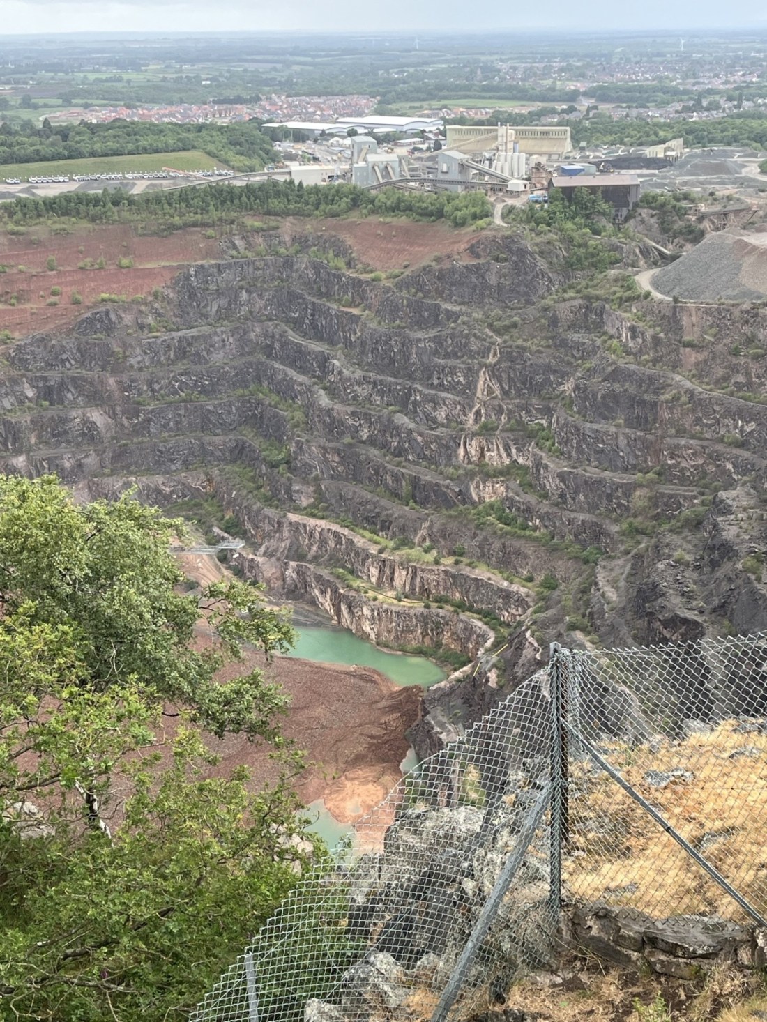
Mission accomplished, I retreated to the bench and stone combo. A short distance to the left provided a partial view of the quarry looking north-west. I had expected to see something quite significant, but the size of the hole in the ground was far bigger than I had expected. Largely overgrown on its higher slopes I wondered if there were any items of a policeman’s uniform hidden in the undergrowth. If you are wondering why I was thinking this you’d be right to ask.

The view from near the bench
At the time of my visit there had been a national news story about a Leicestershire policeman whose helmet had been lost some twenty years earlier but had recently been found and recovered from a local quarry. He was delighted with the discovery but had no memory of how it was lost, or how it had ended up in the quarry. Quite why this was a national news story was bewildering. Perhaps Trump had lost his phone, or the Russian army was on a day off. Well, I reckon if you had lost your helmet on duty, you’d know about it and remember the moment. And if you couldn’t remember it, your colleagues would and would never let you forget. My best guess was that after a long shift on a Friday night, the squad had some down time where alcohol may have been consumed, and in a moment of abandon the helmet was disconnected from its appointed owner and hurled randomly in an unfortunate direction. Was I now looking down into the quarry in question, and at the scene of the crime? We will probably never know.
Back at the bench I concluded that I had fulfilled my obligation and so started my descent. About one hundred metres on, and another small path appeared to the left. Well, one more look wouldn’t harm. I reached the fence where the view to the west and south was more expansive than before. I looked up to the highest point. Hmmm…. It looked much higher than I had expected, and what was that feature near the edge? Ah! A trig point, and with that realisation an instantaneous sense of mission failure. The journey from York south had been painfully slow and I was keen to press on to Cambridge and some time to rest. But… and it was an important but, whilst I have contented myself with the notion that for various reasons I wasn’t always going to get to the very top of each county, falling a long way short, without adequate excuse, was inherently lame. Reluctantly, I was going to have to address the situation.
Trig warning – top left ☹
Back at the main path I trudged up to the bench and stone location, and then on to the point which I had previously considered the top of the hill. *
I noted that the path carried on, descending away to the right. I dutifully followed and after a short distance it began to rise again. About 100 metres on a large abandoned, graffiti covered building brightened up the overcast day.
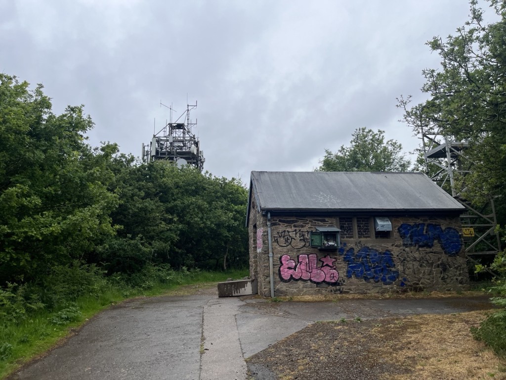
The art of installation
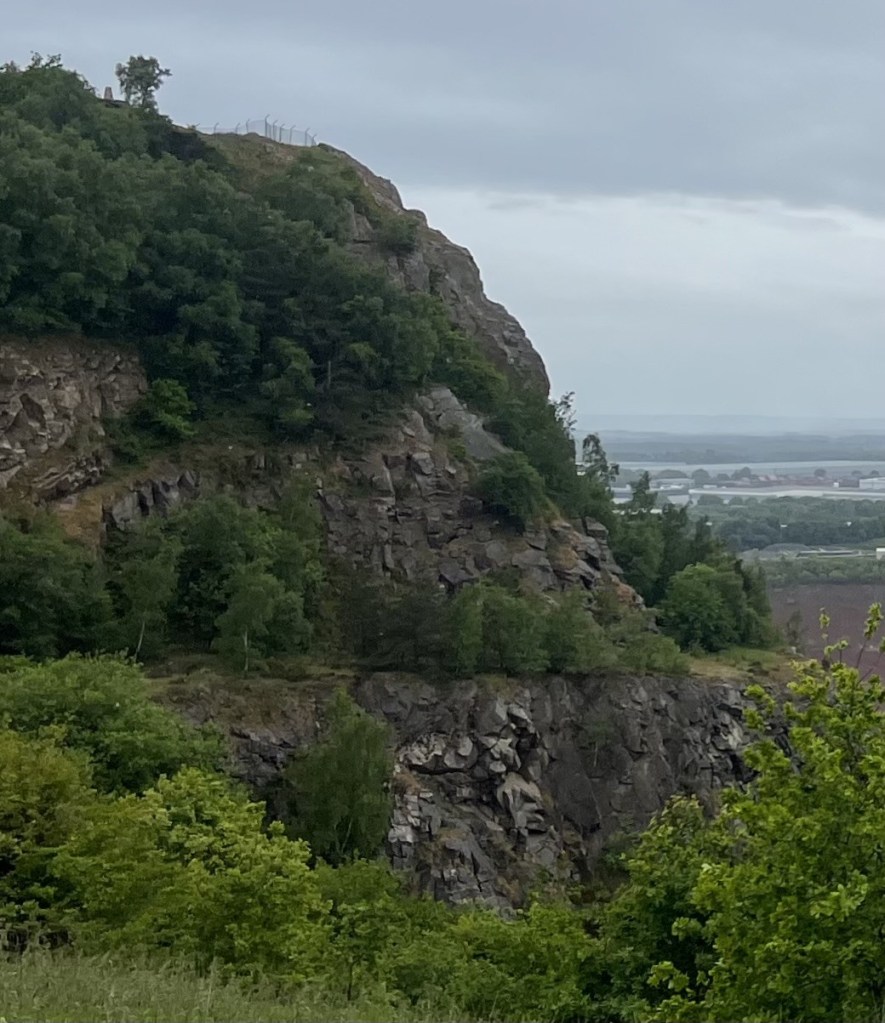
The track meandered onwards, up and down, over rocks and through thickets. Not the easiest terrain. Emerging out of some woods, at last, I had reached the end of the journey. The trig point stood proudly ahead.

That’ll do
Clambering to the very top the view of the quarry was fully exposed, and despite its devastating impact on the hill, bleakly impressive. There was no sign of the Malvern Hills seventy miles to the south-west, but there was a battered information board, that by deduction must have been installed around thirty years earlier, given a reference (top left) to the “recent eruption at Montserrat, West Indies”. 1995 for the record.
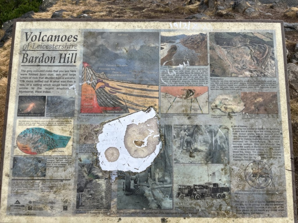
An information board struggling to survive.
I moved over to the railings at the edge of the quarry. Looking down it was very obvious that it was still an on-going operation. The rock was volcanic, and the excavated material aggregate, something, when you think about it, we can’t do without. Once upon a time (570 million years ago by what I have read), a volcano had erupted and created the conditions which, an incomprehensible number of years later, allow us to extract the rock to build roads, support railway lines, and in more inhospitable parts of the country form the basis of paths and tracks that allow walkers and ramblers the opportunity to reach wild summits. No doubt soon after the eruptions stopped it would have been possible to stand on a lip of ground, much higher than today, and look down into the volcano’s caldera. Now I stood slightly aghast and looked down on a man-made caldera. It was overcast and grey, but on a sunny day, with its azure, blue lagoon, I suspected it would be of some strange beauty.

A large chunk of Leicestershire, now missing
I knew from an earlier check that this was not the only large quarry in the area. There were at least another two nearby. The Bardon Hill quarry produces 15% of the county’s aggregates. Whilst larger country’s boast much larger holes in the ground, by the UK’s standards, this is a big one and had been bolstering the nations infrastructure for around 400 years. Well, I’d found out a bit more about my land. I’d enjoyed the climb and what I’d found. If I lived locally I would be clambering up as often as possible (in the hope that on one very clear day I might just see the top of the Malvern Hills). Thirty minutes on and I was back at the car and soon after back on the M1.
An hour or two later, I was driving slowly into Cambridge from the north-west. No dreaming spires on show, but as I approached on Castle Street and looking directly ahead into the heart of the city, I conjured up images of Burgess and MacLean, Philby and Blunt (in no particular order). I turned left into Chesterton Lane, running along the north bank of the river Cam, arriving at the Arundel Hotel shortly afterwards. Parking up at the back and trying to fathom how I had managed to wangle a room here for £70 I soon found my way through to reception, passing a tall, lean fellow wearing a tweed jacket and carrying The Times, which carelessly enfolded a copy of the Morning Star. A woman was working in the office at the back, no doubt sending encrypted messages to Russia, Romania or the USA. She noticed my presence, smiled and approached the counter.
“Good evening,” she said. I smiled and thanked her. “Are you with the party sir?”
Momentarily taken aback I considered the question carefully. “No,” I replied, “just on my own.”
She handed me the keys, but as no further contact was made during my stay it can’t have been the correct response.
* “Top of the Hill” from the superlative album “Bandstand” by Leicestershire’s finest Family.
