Betsom’s Hill
251 metres
823ft
10th May 2024
First things first. The route I am about to describe is not recommended. Not all of it, but certainly the first two miles. It has no merit and is frankly very dangerous. Betsom’s Hill is located close to where the Ultra Low Emission Zone cameras of southeast London, kiss the invisible boundary with northwest Kent, and by all accounts, including the Guinness book of records (according to the helpful local I spoke to for directions), is the highest point in Kent.
Surely that’s already enough to get you excited. I decided to take this mammoth on after a welfare trip to Croydon to run errands and look after the elderly and infirm. Ironic really given that I am quickly becoming one myself. But, hey, it had been a glorious Spring day, and in the late afternoon, a short walk to victory on the way home was an opportunity too obvious to miss.
I parked up on an estate just at the northern tip of Westerham. I figured this was one of the lowest points locally so it would at least involve a climb of some sort, rather than a park up at the top and a quick peek. Returning to my opening comments, this was a mistake. If I had parked up in South Street, just to the north of Betsom’s Hill, the risks would have been low, but the approach would have been from another county. You can see the dilemma.
Once out of the car I immediately headed directly north and within a couple of minutes was crossing over the M25, a river of glittering metal heading both east and west, and partly on the route of the old railway that served Westerham. It was gratifying to know that for today at least I wasn’t part of the scrum.
The road continued north and I hugged an overgrown footpath between field hedges and the tarmac, clearly a conduit rarely used by other pedestrians or cyclists. A mile in and I pass the Velo Cafe. New one to me but clearly a mega hub for the explosion in cycling in recent years, particularly in these hilly parts just beyond the metropolis. Fifty years ago, me and my school mates would cycle out of Croydon and reach these parts before regretting our actions, and then have to slog it up the scarp face of the North Downs to reach Botley Hill (the highest point on the North Downs) before a downhill breeze took us back home. Martin’s Raleigh Chopper was no match for it then, but he never complained and is now a full-on practitioner.
I started on the main ascent with the busy A233 to my right. The footpath continued for another quarter of a mile before vanishing without cause. Private land appears to be the theme round here so no doubt the will to improve the lives of non-vehicle users was dashed against the interests of the landed. What this meant, in effect, was that I had to walk with purpose on the road itself. I was less than happy but the options were, well, non-existent. I crossed over as there seemed to be more room to step off the road and of course it’s usually best to walk against the traffic. This may seem obvious, but it is not always clear cut. Waves of cars, vans and the occasional lorry hurtled down towards Westerham. Each time I’d retreat carefully into the bushes before seizing a moment and then gaining another twenty metres or so of tarmac, and a bit more elevation. This process continued for much longer than I had anticipated and liked. A blue van passed, and the horn was blasted and some words shouted through an open window. I had no idea what the significance was, but based on historical experience I think an accurate interpretation would have been something along the lines of “What the f…, you crazy b……., take a load of this, t…t.” Naturally I was grateful to the occasional driver who moved out a bit, but the truth was this was no place for a human, and every so often the evidence of Spring roadkill was quite apparent.
Towards the top, the steep gradient gave way to a gentler climb, but I had to cross over to the other side because the escape zones had disappeared on the right. As I approached the top I had to cross over again, and then again back to the left side of the road. Despite having my wits about me this had become tedious. Eventually, on the left, a small road, and a building. I crossed back over, recognising proximity to a safer future.
As I arrived at the other side of the road a man in a car pulled into the track and then parked up next to a large house. I guessed this was part of the wider Betsom’s Hill Farm complex and recognised that being a lonely pedestrian at this location might have been raising some small alarm amongst the Neighbourhood Watch teams. Walking up the track that led west, and I believed towards my goal, now felt a bit awkward, and so instead I leant on a field gate, took a shot south, releasing this might be the closest I was going get to the rearing summit and then trotted off along the A233 and to the next small track to the left.
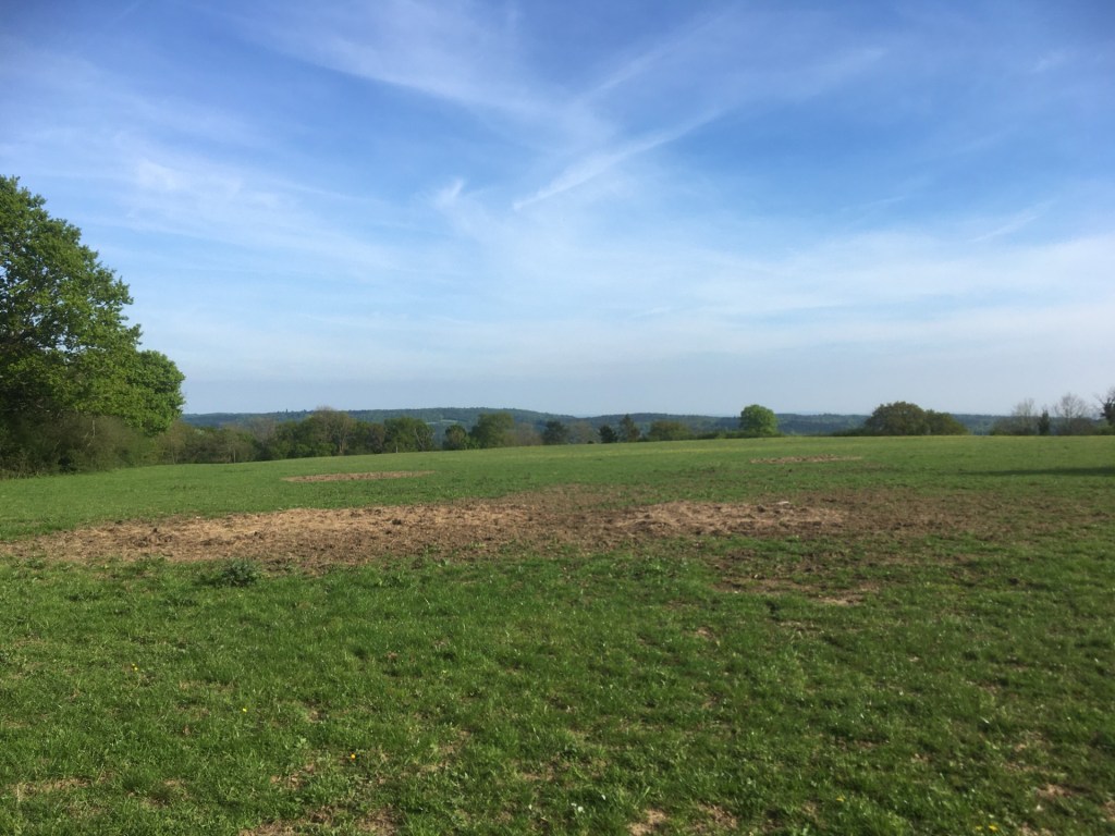
As close as I got.
Another house, and this time a man in his garden emptying the waste. It was hot and I was completely undecided on my next steps, which seemed likely to involve heading back down the bloody main road, and a reasonable chance of calamity. I took a gamble and said hello, and could he tell me where the top of Betsom’s Hill might be.
He’s friendly and very willing to talk. I explain that I’m not a threat, or a council officer inspecting is bin rotation regime, and that I’m trying to get to the top. It’s in a field just up and past the building I had just passed, he explains, but it’s on private land so I can’t reach it. He agrees it’s a shame and adds that there’s an old fort on the site. I ask if it was Victorian. No, earlier. Georgian perhaps (actually, it is Victorian and built, along with several others, as a go to defensive position to protect London should a hostile force seek to invade). He goes on to explain that if I carry on a bit further and past the Garden Centre (did I know it? No!) and turn left, there was a rough road I should take past Little Bensom’s Hill farm and then a track south to get back to the bottom and The Avenue (did I know it? Yes). This was a very positive interaction and one I am sure he has every err ……. decade?
I half wondered if heading on north an unknown distance, just to be a bit safer, was a wise decision, but given his generously given advice, I thought it would be rude to ignore it and instead take the daft option, which could lead to emergency vehicles and a lengthy road closure. I clung again to hedges until eventually I got to the garden centre. A sign at the road junction pointed to Biggin Hill and Bromley. Greater London. Fortunately, the promised unmade road was on the left and took me along an avenue of old trees, past Little Betsom’s Hill farm, and to the footpath that headed south and back down the scarp face of the North Downs.
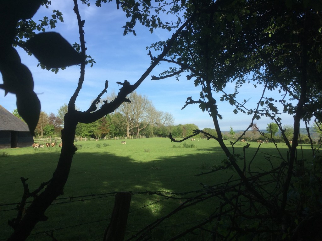
Little Betsom’s Farm. So close!!!!
After a quarter mile or so the path met a six-foot-high wooden fence and then skirted it. I peeked over to see if there was any sort of view at all but immediately realised that I was peering into a very rich person’s grounds, and towards a huge, covered swimming pool that you’d be hard pressed to find bettered on the Costa del Plenty. Voices and some laughter told me that people were at home, and I very quickly ducked my head and carried on down the hill. The fence continued to form a barrier to my right for at least two to three hundred metres, which told its own story, and eventually I pitched out onto another unmade road. This was obviously the Avenue. I recalled passing it on my slog up the A233 and now wished I had done a bit more research before setting out so I could have used this track to ascend. Maybe a sign at the road junction indicating a footpath further down would have been helpful, but I guess that’s just too much to expect and in truth if you lived in one of these exclusive hidey-holes you really wouldn’t want the riff raff passing on a regular basis.
The footpath continued down the slope, through pleasant woods and then ended abruptly on the banks of the Pilgrims Way. Ha! If that’s not a deception I don’t know what is. What was once a long-distance track that allowed people to make their pious way to Canterbury from all points west, is now a pathless road, the purpose of which seemed to exist entirely for the benefit of the super-rich dudes and who own the handful of uber mansions along the northern side of the asphalt. As I headed east and back towards the A233 I was slightly taken aback by the size of some of these pre and post war status symbols. Even the Beatles in their Virgina Water heyday may have been a bit jealous. To the south and beyond high hedges, fields had been given over to growing grapes. I walked the entire half mile back to the A233, hedge hopping again as cars and home delivery vans passed east and west. Not as hair-raising as the earlier experience. Not a single footpath across the fields beyond to be found, but plenty of signs warning of dire consequences if you were to stray off the highway.

Down from the top
I reached the A233 and the Velo Cafe. It was closed. I turned right and at last, now back on a path, I hot legged it back to the car. A beautiful evening spoiled only by the tonked up low riders of the local south London boy racers associations heading south to unknown destinations and unreliable outcomes. I hadn’t quite made it to the top of the topper most point in Kent, but the point I had reached was only a hundred or so metres short, and just a few feet lower in terms of height, and I’d have had to break the law and been prepared to receive buckshot to acquire the prize. It seemed I wasn’t that committed.
At the time of writing there are only four reviews on Google maps. Two are simple star ratings (why bother?). One, from three years ago, just says “Snow, Snow, Snow” with a photo of a kid playing in what looks more like slush and could quite literally be anywhere on the planet where it slushes from time to time. And the fourth and most detailed, a one-star rating from rich80wba saying “Maybe you can get to it via the bottom, but not at the top. It’s effectively someone’s garden and private land. Poor for the highest point of Kent.” He makes some very valid points in just a few words, and as it happens Betsom’s Hill appears to be the only county high point that cannot be accessed by the public.
Back home, and a few hours later I stepped out into the back garden. I noticed in the black night that a whitish haze was gravitating from the north and ending in a sharp point above my head. Probably a high cloud of vapour, I rationalised. I stepped further into the garden and there were more of these hazy apparitions. Like a crown with very long and sharp points. I’d never seen anything like this before and then one of these strands of whatever, began to turn a light shade of purple and I suddenly realised what I was looking at. And it was something I never thought I’d see. At that moment, being at the top of Betsom’s Hill might well have been the ideal spot to witness the aurora. So it goes!

One thought on “Cresting the County – Kent”