Pavis Woods? (Debate)
244.9? Metres
801 Feet
21st July 2024
Chilterns Two Peaks Challenge – Part 2 (in which I disappear down a worm hole of my own creation)
In part one, which is an essential read in the context of what follows, I spent at least, oh, five minutes getting from the car to the highest point in Buckinghamshire. That exhausting and definitive account can be read at
https://wordpress.com/post/elcolmado57.wordpress.com/796

Haddington Hill – Apparently the highest point in Buckinghamshire and the start of the next journey
After leaving the path from the woods, where the highest point in Buckinghamshire is marked by four stones and a reminder of monarchy, I headed east on a road that led out from the car park at Wendover Woods visitor’s centre. After a while I got a bit bored of walking on the road and noticed a path leading onto thick woodland. I had a fair idea of where I was and wasn’t too bothered if it led me slightly astray.
As soon as I stepped into the woods, I spotted a small deer grazing in a clearing just 20 or so metres away. By its size I suspected a muntjac, but at that moment it sensed my presence, looked up and then with a couple of skips disappeared deeper into the woods. In that moment I’d noticed a small tail. I’ve subsequently looked at images of deer on Google to see if I could identify the type (which I was pretty sure wasn’t a muntjac). In the end I couldn’t, but here’s a tip. Don’t search for images of red deer unless you want to see a lot of pictures of mainly men in camouflage gear, and holding high powered rifles, gloating over their trophies. Big guys!
The path soon rejoined the exit road, which in turn met with a B road (St Leonards) at Chivery Farm. I dithered for a while, trying to get my bearings, but after consulting with my 1983 Ordnance Survey Landranger map for the Aylesbury area, I decided to turn left, and after some 400 metres came to a bridleway on the right and heading east.
This was either the Icknield Way, or the Ridgeway, or possibly both? Breaking out of a line of trees a very green, grassed covered dry valley fell away to the left, with the only expansive view along the entirety of the walk. A dozen or so swallows swooped up and down the valley feasting on whatever was on the high protein menu that day. To the northeast the scarp slope of the chalk downs at Ivinghoe Beacon (an area well worth a visit) was just visible.

Towards Ivinghoe Beacon and the Tring salient (see Buckinghamshire)
Looking back and a large manor house, which had clearly been subject to a significant facelift. Two huge timber framed glass extensions protruded south from the main body of the older building. Quite how the developers managed to slip this past the Planning Committee will remain an un-researched mystery to me, but I could see the attraction.

Life from a window
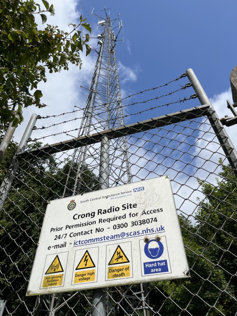
This section with the views ended at a gate that led into more beech woods. The path through the woods was flat, although at times it was possible to make out the land falling away to the left. My objective was Pavis Woods, where the sources indicated the site of the highest point in Hertfordshire, just over the Buckinghamshire border. To get to Pavis Woods, I had to walk through Black Wood and then Northill Wood. In truth, with no obvious border, change in altitude, or tree type there was nothing to tell them apart. Except, where the path spilled out onto Bottom Road, a small lane that plunged down the scarp slope to the north, it was hard to miss the Crong Radio mast, which given its location and height, almost certainly makes it, technically, the highest point in Buckinghamshire. I’d never heard of Crong Radio and presumed it to be a hangover from the days of pirate radio, specialising in a sub-sect of music only known to a sub-sect of the nation’s youth. Instead, it turned out to be the local ambulance radio transmitter.
You have been warned
I left the radio mast to its important business and then passed a derelict breeze block building that could have served a variety of purposes over many decades but was now an ever-changing open air modern art gallery, to which someone had controversially commented CRAP. I wasn’t so sure.

Where Romanticism meets Expressionism
As I have mentioned, Northill Wood was essentially the same as Black Wood, and where Pavis Wood started it was impossible to tell, but the walk was pleasant enough. Just towards the end a walker approached from the opposite direction. The only one of the day so far, and judging by the kit, was taking on a tougher challenge than me.
As I arrived at the gate exiting the woods a horse and rider appeared on the other side. Due to an ingrained inferiority complex, and the fact that the horses bearing was considerably more authoritative (big), I gave it and its rider priority. Beyond the gate was a road, and I figured that I had now left Pavis Wood. Which, given that the highest point in Hertfordshire was supposed to be in Pavis Wood, represented an issue. I went back into the woods and looked around to see if there was anything to mark the location. It was certainly the highest point at that point, but only by inches. And there was no marker.
Going back to the road, where, out of the trees it was a bit lighter, I got out the old Ordnance Survey map again. Something had been troubling me, and once I had managed to wake up the optic nerves and achieve some focus, I began to understand the issue. The perceived on-line wisdom was that the highest point in Hertfordshire was in Pavis Wood. The problem was that the Ordnance Survey map, unlike the map on the phone, showed the county boundary running along the middle of the road, which left Pavis Woods in Buckinghamshire. That said, further to the north, the boundary did bisect some of the woods. I studied the map as closely as I could. It showed a height marked at 244 metres in the field opposite, in Hertfordshire.
I was baffled and confused. On one side of the road I was in Buckinghamshire, and stepping over to the other side I was in Hertfordshire, but whether I was at the correct spot or not was entirely debatable. At least I was out of the woods, and as the weather was overcast, cool and very windy, and I was only wearing a T-shirt and shorts, I was happier out of the woods for a bit, where the possibility of an occasional ray promised.
The appropriately named Shire Road went south, and wagering on a footpath that would take me in an arc to the village of Hastoe, I set off, looking left and right to see if there was any slight deviation in the lay of the land that might have indicated a high point.
It was pleasing to be out of the gloomy woods for a while, and after ten minutes of losing altitude, a footpath appeared on the left hand side of the road. A quick consultation of the map and I took it. The path followed the line of a high hedge that, according to the map, marked the line of Grim’s Ditch. I’d noticed on the map that some forty years earlier, presumably when I purchased it, I had marked out the route of a much longer walk I had taken when young and more energised. I remembered it well. A train out of London to Amersham and then west through the country and some villages until I turned back east at Redland End, and for a mile or two along another section of Grim’s Ditch, ending the walk at Great Missenden. At the time I distinctly remember stopping for a while, taking a couple of photos, and considering what purpose these earthworks might have served. Of course there was no way of finding out in those days, unless I was prepared to invest considerable time researching the issue at a public library, and looking back now, I’m pretty certain I didn’t do that. Today, within a few moments of tapping, I find that they are probably from the Iron Age and their purpose remains a mystery. I think it’s quite reassuring to know that even now we don’t know everything, but once you know they exist, and seen them on a map, a little bit of me is inevitably curious. *
After a couple of hundred metres the path was crossed by another, which angled north-east and back up across a large wheat field directly towards the village of Hastoe. As I walked up through the field it was clear that the land to my left rose to what appeared to be a higher point.

The old straight track to Hastoe
I reached Hastoe, turned left and along a rough road towards the heart of the village. To suggest it had a heart is probably an exaggeration. Hastoe was pleasant enough, but its handful of eclectic houses, set back from the road, and with a large complex of imposing redbrick buildings at the junction with two other roads, implied perhaps that at some point it had been part of a large estate, and that what was now a large and exclusive development had once served a different purpose.
I turned left again along Gadmore Lane and back towards Pavis Woods. The road rose steeply for a bit before flattening out on the approach to the woods. To my left was the far end of the field I had crossed, and through the hedge I could see that the land appeared to rise towards a thicket of trees. If I wasn’t actually standing at the highest point in the county, I was pretty sure that I had done my level best to circumnavigated it. Before plunging back into the woods, and largely due to an irrational worry that I had missed something important, I did some more Google searches. What is the highest point in Hertfordshire? The results only seemed to confuse the situation. Pavis Woods came up repeatedly, and one even put the point two or three hundred metres to the north, which unless I really was misreading the topography, just couldn’t have been true. I concluded that I was just wasting my time, and rather hoped that the signal on the phone would stop working. Pavis Woods, or at least the part of it that I was about to enter, was firmly in Buckinghamshire. The clumps of trees at the top of the field opposite were firmly in Hertfordshire.

The highest point? Who knows, it remains an enigma.
The walk back was along the same route. The weather didn’t improve but at least it didn’t rain. By the time I passed the sign pointing to the highest point in Buckinghamshire I had walked about six miles, which was more than I had expected when I had set out. With the cackle of gunfire wafting up on the wind from the ranges down in Wendover (Storm Lilian was beginning to make its impact), I enjoyed a coffee at the back of the attractive cafe at the woodland centre, where, if I had only known, I could have gone Ape at the nearest treetop facility. Hey, next time, maybe.
Driving back south on the A41, the police had taped off the outside lane. A car had inexplicably driven straight into, and was wedged under at 90 degrees, the central barrier. It didn’t look to good, and I guessed that Crong Radio had played its part in the emergency response. Beyond the accident, and within moments, I was being overtaken by high powered vehicles hurtling on their way, nose to tail and far too fast.
*
A bit like the mystery of Grim’s Ditches (plural), I have subsequently devoted far too much time trying to pin down the exact location of Hertfordshire’s highest point. The well-known font of all on-line knowledge, Wikipedia, didn’t seem to hold the answer (it being a proponent of the Pavis Wood theory). Google maps definitely didn’t resolve it. The scale of my OS map was too small to drill into the contour detail but did at least have a clear 244 marked in the field with the clump of trees. But it still wasn’t conclusive. A tangential search, because I wanted to know for sure that I had been walking on chalk (it wasn’t obvious on the ground) took me to the British Geological Survey’s Geology Viewer. ** The viewer confirmed that the ridge was chalk (Lewes Nodular and Seaford Formations to be precise), but then I noticed, as I hovered the mouse arrow around the Pavis Wood area, that in the bottom left it showed not just the grid coordinates, but also the precise height at every point. This was a game changer. I moved the arrow slowly and in a circular motion around Pavis Wood and the field adjacent to Shire Lane. 245 metres was the maximum elevation, and indeed the map showed a height point on the road just south of the junction stating 244.9 metres.
I could still be wrong, but based on everything I have looked at, I am almost certain that the highest point is just beyond the hedge in the field on the Hertfordshire side of Shire Lane, and about 50 metres south of the junction with Gadmore Lane. And that’s a fact?
* Curiosity. I was surprised to find on my bookshelves that I still had a 1970’s copy of the seminal 1925 book “The Old Straight Track” by Alfred Watkins, in which he propounded his theory on the existence of ley lines. Given that, 99 years on and there remains a mystery surrounding the linear Grim’s ditches, I wondered if Watkins had a take on them. He didn’t. They get a brief mention, albeit meaningless and without any context, in another book I have on the subject “Lines on the Landscape – Leys and Other Linear Enigmas,” by Pennick and Devereux -1989 (what was I thinking when I joined that book club?). Enigma indeed!
** If you want to know what’s below your feet, or whether your home is built on granite (good), chalk (hmmm) or mudstone (eerrr..!), the BGS Geology Viewer is, in my mind, the greatest thing on the internet. Geology aside, what it shows in terms of on the ground detail is extraordinary. It’s a worm hole worth a visit.
https://geologyviewer.bgs.ac.uk/?_ga=2.58458858.1363630663.1720815697-999374144.1720815697
