Corfe Hills
79 Metres
259 feet
1st April 2025
A Layby High
This one ought to be brief, but unashamedly I’ll draw it out for dramatic effect. Now that Unitary Authorities (UA’s) had entered the equation and given that I was travelling from Lyme Regis to stay the night with a couple of old work colleagues in Portsmouth, I felt obliged to seek out the highest points in Poole, Bournemouth and Christchurch, which according to my enormous map of the UK were three separate UA’s. Given that each lay approximately on the route, I considered that locating and cresting each would be fairly straight forward.
In my room at the Nags Head Inn the previous evening I had spent some time on the laptop typing in search variations for the highest points, and to be honest it was tying me in knots. I had confidence in the location for Poole – Corfe Hills – but searches for Bournemouth and Christchurch threw up various options, which often seemed to find their way back to the Corfe Hills. Surely it couldn’t be the highest point for all three authorities. I couldn’t fathom it out, so in the end gave up, went out for something to eat and a couple of beers before the slow trudge back up the hill for a whiskey nightcap, and a nod and a wink to the framed photo of Harold Wilson that hung on the wall of the bar. Whatever else, he’d see me right.
I drove out of Lyme Regis, took to the A35 and stopped for a while in West Bay, where I sat on the cob for an hour contemplating the rapidly retreating Jurassic cliffs to the east and west. Given that West Bay is definitely not in the oldie woldie West Country tradition (apart from a small cluster of older buildings by the harbour) there was something about it I really liked.

The cliffs in retreat – West Bay
Back on the A35, and taking the high road above Chesil Beach, with not a cloud in the sky, the views towards Portland demanded a couple of mandatory photo stops; which in the end singularly failed to capture the mood, but here you go.
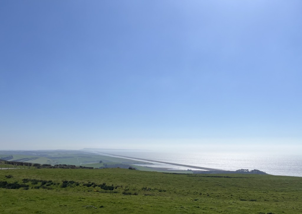
Chesil Beach to Portland
It took another ninety minutes to get from Abbotsbury to the outskirts of Poole (navigating the English south coast by road is, if you’ll allow me to dabble in metaphor – no small walk in the park). Even though it was only a few weeks ago now, I couldn’t tell you a thing about the drive into Poole, and nor do you need to know either, but from my map research I had a fair idea of where I was going. Naturally, trusting in my outstanding memory and recklessly not having a sat nav system, I did get into a bit of a pickle at a point where the A35 encountered multiple roundabouts. Thus, after some pottering about in a carpark between an Aldi and a B&Q, I was heading north on Broadstone Way, and then at Broadstone itself turned left at another roundabout onto Higher Blandford Road. I was now within touching distance of my objective.
Higher Blandford Road headed steadily up for about a mile, then levelled out with a large school to the left before starting to show signs of descent, at which point I pulled over, turned the car around, and back near the school pulled over at a handy layby. I wasn’t sure if I needed to get out of the car, given that I was 100% certain I had arrived at the correct spot, but I had been driving for what seemed like hours and so stretched my legs for five minutes, taking in the impressive view of a modern school and a communications aerial opposite. Judging by the moans and groans of two men hidden behind the tree flanked heathland next to the layby, their search for a lost ball or two indicated a golf course.

This should put most people off – the top of Corfe Hills with the golf course beyond

Yup ☹
It was now just past 2pm. My ETA in Portsmouth was around 5.30pm, so despite not being in a rush I was going to have to get my skates on if I was going to get to grips with the highest points in both Bournemouth and Christchurch, neither of which locations I was sure of. Back in the car I did another search for Bournemouth and again it threw up Corfe Hills. It was patently a lie, given that where I sat was clearly in Poole and the border with Bournemouth was miles away. Another option was offered up. Hengistbury Head. Well, a nod is as good as a wink as “they” say, so off I went.
Another 30 minutes on and eventually I pulled up at the side of a long road near the seafront, with rough grassland either side, and in the distance the low hump of Hengistbury Head. A pleasant enough looking spot, but I was slightly doubtful about the “highest point” claim. In any case, I’d been driving for hours and needed to properly stretch my legs.
A brisk wind but a crystal-clear day, I walked the tracks to the gradually rising land and after no more than a mile was standing at the top of Hengistbury Head, looking out across the Solent towards the Needles at the western tip of the Isle of Wight.

Towards the Needles and beyond
The wind came from the east (a constant trend in recent weeks; increasingly becoming the prevailing direction) scuffing up thousands of white horses on the crest of the waves. Looking to the northeast a sandbar almost, but not quite, connected the Head to the mainland; lined its entire length with what appeared to be beach huts. I realised that I didn’t know this area at all but was in no doubt that each one of those small holiday boltholes probably had a land value higher than anywhere else in the country.

The most expensive real estate – not long for disappearing I suspect
I was standing at 36 metres, yet despite a very tangible sense of elevation, looking back towards Bournemouth, and with the exception of the nearest mile, most of what I was looking at appeared to be higher. Maybe not by much, but certainly enough to convince me that this wasn’t the highest point in the borough.

West to Bournemouth and higher ground
I appeared to have been duped, but didn’t regret having found this spot. If you happened to live nearby It is a magnificent asset to have on your doorstep. Walking back to the car I passed the visitors centre, a small enclosure that boasted what appeared to be a replica Iron Age roundhouse; apparently built to ancient beach hut style and standards.
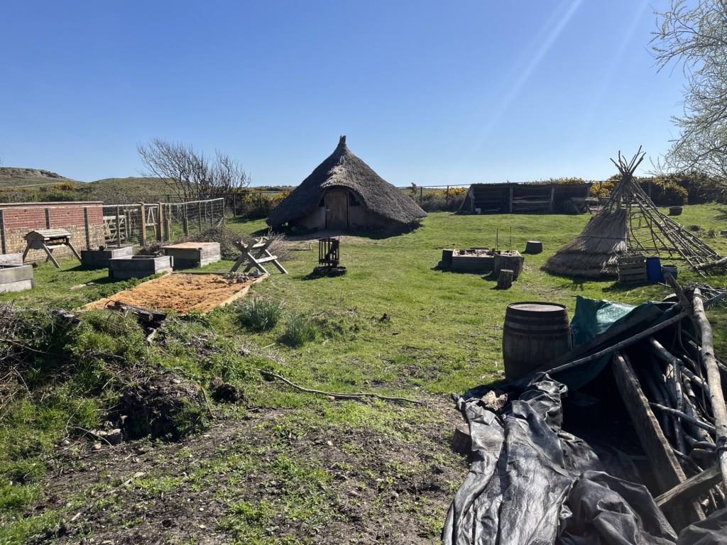
An insight into the beach life of our ancestors
A quick coffee at the nearby Hiker Cafe and then back to the car for the onward journey to Portsmouth. Time was pushing on and I was no longer enthusiastic about hunting down Bournemouth’s highest point, let alone any further investigations in Christchurch. These UAs were proving to be trickier than I had expected.
So, here’s the thing. In 2019 (five years after the publication of my very big wall map), the three separate Unitary Authorities of Poole, Bournemouth and Christchurch were combined into one single UA. And that, I can tell you, is a blessed relief, because, let’s face it, life really is too short. Delightfully, Corfe Hills were all I had needed to do.
Ah well, so it goes.
