Tair Onnen
137 metres
449 feet
12th September 2025
Bus Stop Quandy
After five fascinating exploratory days in South, and south-west Wales, it was time to head home. I’d spent the last night in Cardigan, after climbing Foel Cwmcerwyn, the highest point in Pembrokeshire. Having checked into my accommodation I took a stroll along Cardigans attractive historic high street, then over the river Teifi and to the fine-looking Castle Inn.
So many old boozers have had their internal organs ripped from them, often resembling sanitised airport style cafes, that when you walk into one that looks like it hasn’t changed in a century, and hasn’t been illuminated up to the gunnels, it is barely believable. I ordered a pint and found a table and chair where, in an underlit snug, I could look out of an old window and across the waters.
It had been daylight when I had entered, but in the few minutes it had taken to purchase my beer and sit down the day had turned to night, and as if on cue the heavens had opened and rain was lashing down on the tidal swell. The movement of the dark water, where river and sea merged whilst gale fuelled rain pounded the surface, was mesmerising and I just sat and watched as behind me two young women caught up with their respective lives over pints of stout. In that moment all was right with the world.
I would have liked to have spent an hour or two mouching around Cardigan the following morning, but I had over 300 miles to drive and hadn’t taken the precaution of breaking the journey back. I was also planning to take a slight diversion from the main route and see if I could locate Tair Onnen, the highest point in the Vale of Glamorgan.
It’s highly likely that I took an entirely unnecessary long route along the lanes south and east of Cardigan, but I was in no rush, and it was almost traffic free quality countryside. I reached Carmarthen and continued down the A48 and then the M4. The blast furnace (now dormant) and steel works at Port Talbot dominated the view to the right for several miles. I once had a conversation with a friend about industrial buildings and brutalist urban landscapes. I think I was trying to suggest that there was almost always a strange beauty in nearly all things. She was having none of it and quoted some geezer who had famously (apparently) said something along the lines that if you see an ugly building, to save your soul, never look at it again. There is no doubt that Port Talbot, in any traditional sense, is as ugly an industrial stain on the landscape as you’ll find, but, like the tidal dance of the Afon Teifi, I have been mesmerised by it on the few occasions I have passed by. Today was no exception. If there had been a stopping opportunity, I would have spent some time trying to absorb it all, but there wasn’t and so I carried on south and then east to Bridgend, then leaving the M4 and rejoined the A48 towards Cowbridge. *
Past Cowbridge the land gently undulated, with large fields (mainly stuffed with maize), to left and right. At a point where the road began to rise and swung slowly to the left, then to the right, I was visualising my location and knew I needed to be pulling over soon. Moments later a lay-by appeared on the left and I duly stopped. Looking across the road, I could see the field, recently ploughed, that held the county top (a distinctive farm building sitting proud on the skyline).
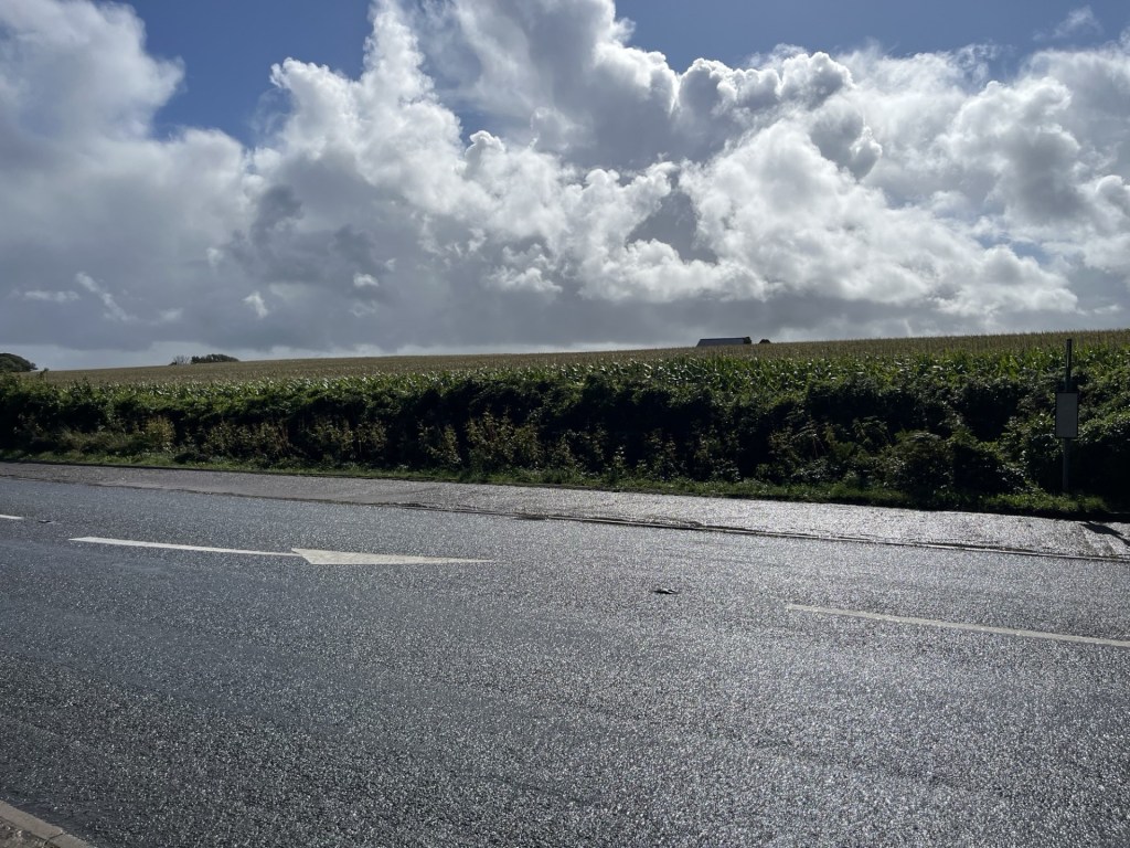
7 metres below the high point, just to the left of the farm building pictured on the ridge
I already had a predetermined plan of attack, based on earlier close inspection of the site on Google maps. I would walk east along the footpath at the side of the road until I reached the end of the field, hope to find a footpath to the top, take a snap of the trig point and then head back the way I had come. I had factored in a 15-minute walk.
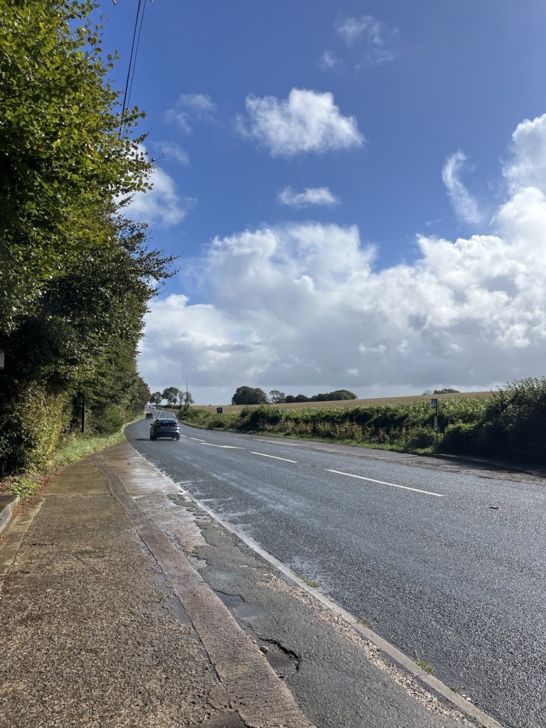
I got out of the car with the intention of getting my walking boots from the boot (English doesn’t make any sense sometimes), but before getting to that point I took a longer look around. As I surveyed the landscape and surroundings, bit by bit my confidence began to stutter. The most obvious issue was that the field appeared to be much larger than it had seemed on Google maps (which of course it blooming was). The road stretched away into the distance, as did the field. Based on the visual evidence it felt like any attempt would take at least 30 minutes.
I had also been under an assumption, based on what I had seen on Google maps, that there would be a pavement along the side of the road which would enable safe and swift movement. The reality on the ground was a sad disappointment. There was no pavement on either side of the road, and whilst there was a verge, it was lumpy, uneven and soaking wet. Essentially, given the flow of traffic, it was looking like an unexpectedly high-risk venture.
Stranded at the bus stop
Along with the distance and roadside dynamics, whilst it was a reasonably large stopping area, it doubled up as a bus stop, and I wasn’t too comfortable with the idea of leaving the car for too long.
Without any pavement, this, and the bus stop opposite, were hideously dangerous to access for any pedestrians.
There was one last and obvious disincentive. The weather. Even if I had been prepared to risk life and limb clinging to the edge of the highway, in the half hope of finding a path further down the road than I had originally anticipated and taking a risk that the car would survive unattended, the chances of making it without a serious soaking looked almost nil. I still had 200 miles to go, and I intended to do it dry.
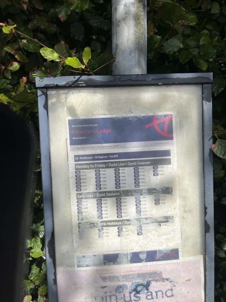
Foresters Lodge bus stop. Two buses an hour!! Who for?
After reading the bus timetable (there appeared to be a reasonable service) I took another look around. I wondered how on earth anyone could access this and the stop on the other side of the road, without running the risk of serious harm. A thick hedgerow backed onto the stop and ran in either direction for twenty to thirty metres, and with nothing other than a rough strip of lumpy grass between it and the 60 mile an hour A48. It didn’t look like a location that would necessarily generate a lot of potential passengers, but if I was a parent and had a child who relied on the bus to get to and from school I would be freaking out every time they set off. I guessed that the only safe way to get to the stop would be by car (the irony).
As I returned to the car, a single decker bus shot by. It made no attempt to stop. To be fair I hadn’t hailed it, and the driver might have put two and two together vis a vis the stationary car, but how could he or she have known for sure? I drove off and was soon on the outskirts of Cardiff. A ring road took me north and onto the M4, where the traffic ground to a halt. I should have been able to get back the River Severn and across the bridge in just over thirty minutes, but it was well past Newport before the traffic began to ease. An hour and forty-five minutes to do the 33 miles. A couple of years ago the Welsh government managed to annoy a whole lot of Welsh people, and even more English people with no skin in the game, by reducing the speed limits in many urban, town and village settings to 20 miles an hour. Anyone would have thought the French had invaded. I’m not sure if the person who owns that expensive electric vehicle company chipped in but it’s exactly the sort of thing he would have.
I had just spent five days in Wales, avoiding where possible the M4, and by and large driving on rural A and B roads. I passed through many settlements of varying size and discovered that these pesky 20 mile an hour limits caused, well, they caused almost no inconvenience at all. There was one small town deep in the country where I did think that the speed limit extended an unreasonable distance but overall, I genuinely couldn’t work out what the fuss was about. Having lived in London when the 20 mile an hour limit was widely introduced, I am possibly more relaxed about it, but what a lot of hot air over almost nothing. So, having taken an hour and forty-five minutes to go just over thirty miles on Wales’s premier motorway, with no obvious sign of roadworks or accident, the irony that I had averaged just 20 miles an hour throughout was not lost.
I have strayed too far. What was the subject again? Ah, reaching the highest point in the Vale of Glamorgan. ** Well, I didn’t make it to the top of the county, but I could see it from the road, and that’s probably the best I could have done under the circumstances. Taking a look on Google maps I have since realised that there was another bus stop about 300 metres to the east at the end of the field. A sign on the opposite side of the road points to a footpath. Whether or not the path went to the trig point or just flanked the field I have not been able to determine, but what Google does show is that just over the brow of the hill, and facing south towards the Bristol Channel there is a large area of land covered in solar panels. A solar farm, I guess. I think I would have liked to have seen that. Oh well, another time (you’re kidding!). ***
PS. Just over a month on, and before I had finally finished off this account, I was flicking through the December 2025 edition of TRAIL – a climbing and hiking magazine that my daughters partner gets monthly. Towards the middle there’s a two-page feature called “High and Low’s – 10 of the most curious County Tops”. Apart from being flattened by the fact that the whole county tops thing seems to have gone stratospheric, more astonishingly I had done four of the ten referenced, including, and this really knocked me for six, the Hill with No Name – The Top of The Vale of Glamorgan, along with an image taken from an OS map. For copyright reasons I won’t quote the short article, but the author noted that annoyingly, there’s no public access.
* I prefer a quote I have found by Matt Haig which reads – “If you think something is ugly, look harder.”
** I have since discovered that apart from the Vale of Glamorgan, there is no such place as Glamorgan. That has come as quite a shock. The old county of Glamorgan, or, Glamorganshire, covered most of south Wales. When I was a kid, I remember watching, in black and white, and probably on the news, one of the most amazing moments in the history of sport. Never mind Leicester winning the Premier League in 2016 or Gordon Banks save against Pele, when Gary Sobers, the then captain of Nottinghamshire County Cricket Club, hit six sixes off Glamorganshire’s bowler Malcolm Nash in one over at Glamorgan’s ground in nearby Swansea, no-one in the history of cricket had ever seen anything like it before. And it was on TV! On the BBC! On terrestrial TV! And it was free! And it’s still on YouTube! Gawd bless yer Aunty.
*** Just in case you feel a bit let down by this account and need to know more about how to reach Tair Onnen – the main man – Richard Gower has provided this helpful guide (should have read it first – doh!), though according to TRAIL, it’s inaccessible!!!
