After the night before (when Spurs had beaten Manchester United in the UEFA Europa League Trophy final, and after I had chalked off Rutland and the City of Leicester), I had one more day in Nottingham and felt the need to visit its highest point. I say I felt the need, but that’s not strictly true. To be honest I was just slightly hungover. Nothing that I was regretting, but just that slightly off feeling that thankfully I hadn’t felt in some years. Either way my brother was working from home, and it was important that I got out of his hair (of which he is still blessed, and I am not).
I’ve been to Nottingham many times; on a couple of occasions in the 1970’s on day trips from Leicester to the Old Trip to Jerusalem and other hostelries, but many more times after my brother moved there in the late 1980’s. I have to say it never occurred to me that it had any land higher than the site of the castle (which remains one of the world’s biggest disappointments, especially if you’ve ever seen any Robin Hood films). For everything else you’ll ever need to know about Nottingham, and the engineering beauty (!) of Maid Marion Way, I can’t recommend enough Mark Steel’s – In Town – Nottingham on BBC. *
I had discovered that the highest point in town was a place called Mapperley located vaguely somewhere in the north-east. Dosed up on coffee I drove directly towards the city centre, which involved passing the Trent Bridge cricket ground. There were a lot of people mingling around but I didn’t put two and two together (probably a county match I mused), and carried on over the bridge, with the Forest ground to my right. I should say a couple of things about Nottingham Forest’s City ground (just to string this relatively brief account out a tad more).
I’ve been there a few times with my brother and sister-in-law over the years, but mainly during Forest’s leaner years. The first time I went was with a die-hard Brighton fan called Trevor. From memory it was the second leg of the League cup quarter final, on a freezing winter night in December 1978, and for the life of me I can’t remember what convinced me to go or (being that I was from Croydon), why he had invited me in the first place. This was about the time when Forest were about to make history and had the classic Brian Clough line-up. We took a bus up from Leicester and by kick-off we were in with thousands of Brighton away fans.
It was an exciting game. The Brighton fans were boisterous throughout, but in the end Forest were triumphant, and eventually we set off back to the station (the surroundings of which have changed out of all recognition in the intervening years: the delightful Victorian Bentinck Hotel pub, now a desultory Starbucks) with the thousands of others who had made the long journey from the south coast. And that of course is where they left us, and we had to make our way to the bus station, on our own, in the rain, and with Trevor refusing to zip up his coat and cover his blue and white Brighton and Hove Albion scarf, despite my whimpered pleas to his conscience. With the streets still crammed with celebrating Forest fans, I had never felt more exposed. Dirty, threatening looks, abuse and the possibility of violent intervention at any time convinced me that if we survived the night and escaped Nottingham unharmed, I would definitely not travel with Trev to a Brighton away game again. We eventually made it out of town on the late bus to Leicester, and I kept my promise.
The other significant moment, just outside the City ground, was some years later when walking along the river Trent footpath with my brother and their dog. We were the only people about until ahead of us a group of male athletes on a powerful jog headed towards us. As they closed in my brother speculated that it was the current Forest team, and sure enough, as they passed, I recognised one or two. “Morning lads,” came the heavily Glasgow accented greeting from the older man at the rear. On the 11th of June 1978, Archie Gemmill had scored the greatest Scottish goal of all time against Holland in the World Cup in Argentina. As a Scottish family living in the diaspora we had watched the game, more in hope than expectation. When Archie scored his wonder goal the roof nearly came off the house, and in many Scottish towns and cities there are still buildings with structural damage from the resultant seismic aftershocks. Scotland won the game, but it wasn’t enough to qualify for the knockout phase, but it didn’t matter. Archie was God, and he had just spoken to us.
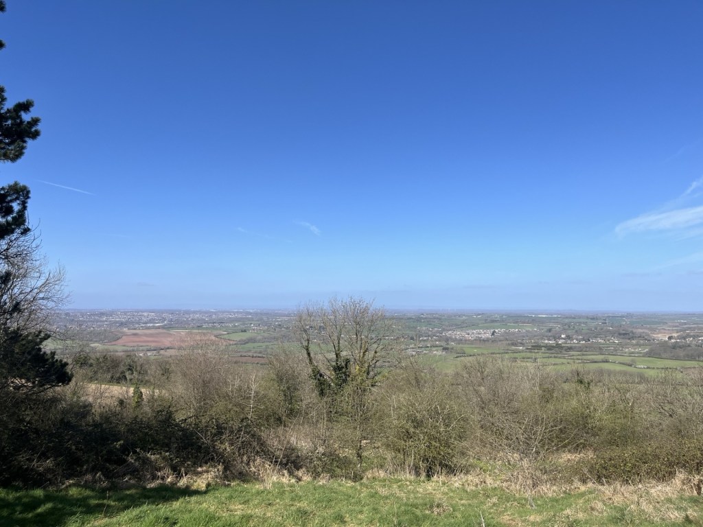
I drove further into the town centre and, without incident, managed to find myself heading north-east on St Anne’s Wells Road. I turned left at Ransom Road, simply on the basis that it headed upwards, often a useful clue in these situations. To my surprise the road rose steeply with interesting parks to the left and right. At the top I turned right onto Woodborough Road and eventually pulled up in the carpark of an Aldi to get my bearings. I was in Mapperley, and a quick check informed me that the highest point was just a short walk further to the north-east. The sign said I had two free hours, so long as I shopped in the store. It was going to be a risk, but I figured that the chance of parking up, not making a purchase and being caught, was low.
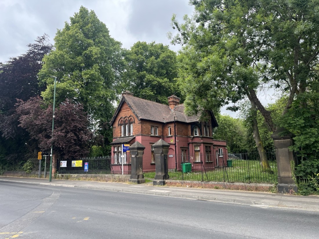
It was just a three-minute walk. The highest point seems to be at the rear of a bleak looking Victorian block of flats set behind some grim railings and gloomy woodland just opposite the busy and confusing junction with Porchester Road.
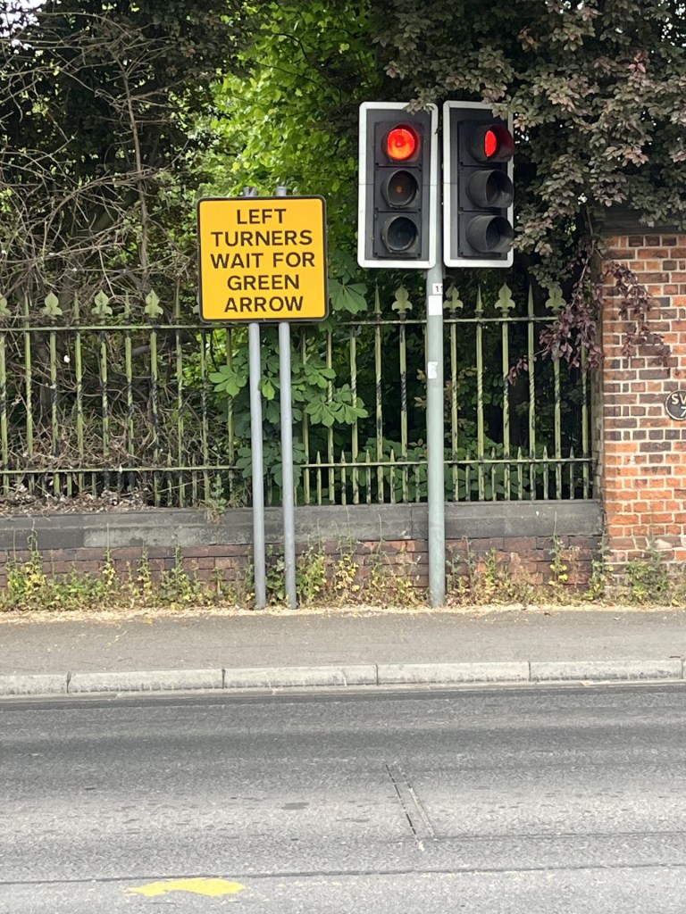
There was no helpful instruction for Right turners.
I passed on by. The oppressive heavy-duty railings continued to line the left-hand side of the road, behind which was what appeared to be a grass covered reservoir.
The grassy uplands of Mapperley
The highest point appears to be the back garden of this indeterminate bleak house
Walking back to the car I looked around at the most eclectic collection of buildings you could find in any place in the country. Mainly Victorian and early 20th century not one of them looked like the next, and without exception, other than a strange quirkiness, none had any architectural interest or value. It seems that high ground to the east of an industrial city does not a garden suburb make.
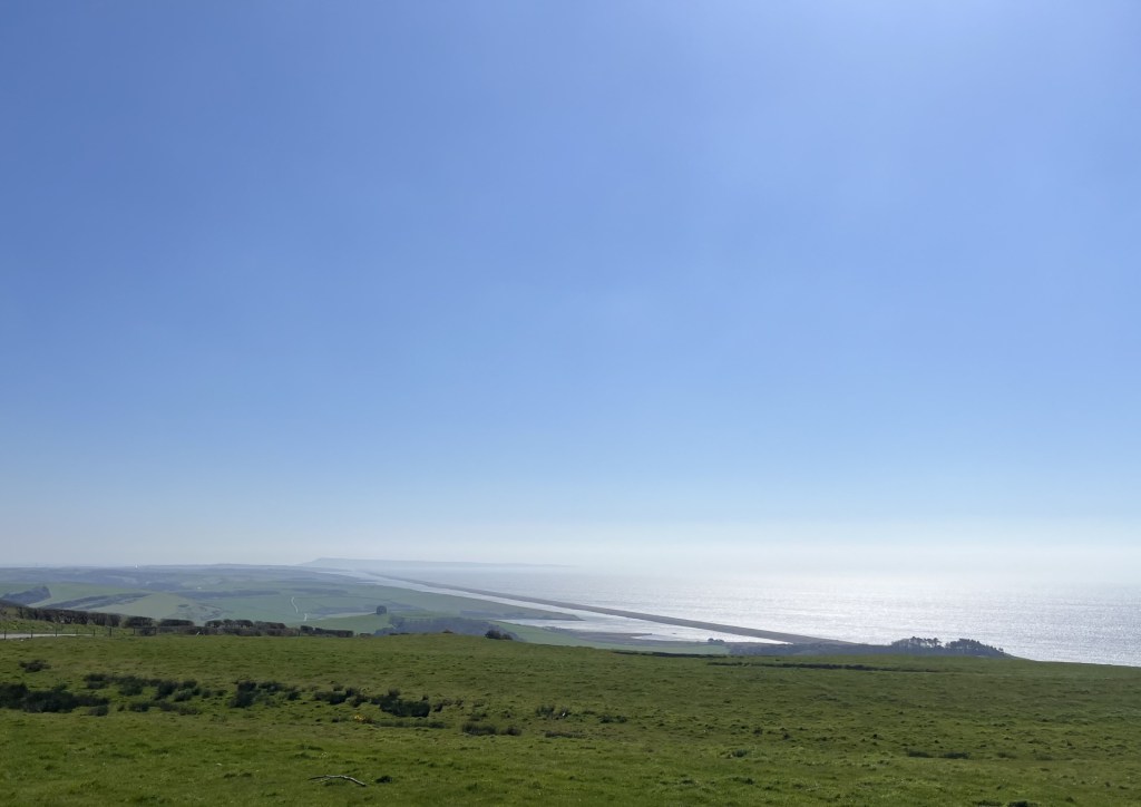
I’d chalked Mapperley off the list but still had a few hours to continue my Nottingham investigations. I had an objective. Something I had been aware of for some years but had not had the opportunity. I drove back into the centre, navigating tricky road layouts, past the castle and then west, eventually reaching the area of Toton an hour or so later. I parked up on a new estate and then headed into the Toton Fields Nature Reserve. After twenty minutes or so the rising land took me to a point I had hoped existed. I knew I was there because there were a few other people with cameras and binoculars looking down the slope to the west, and the noise below was distinctive.
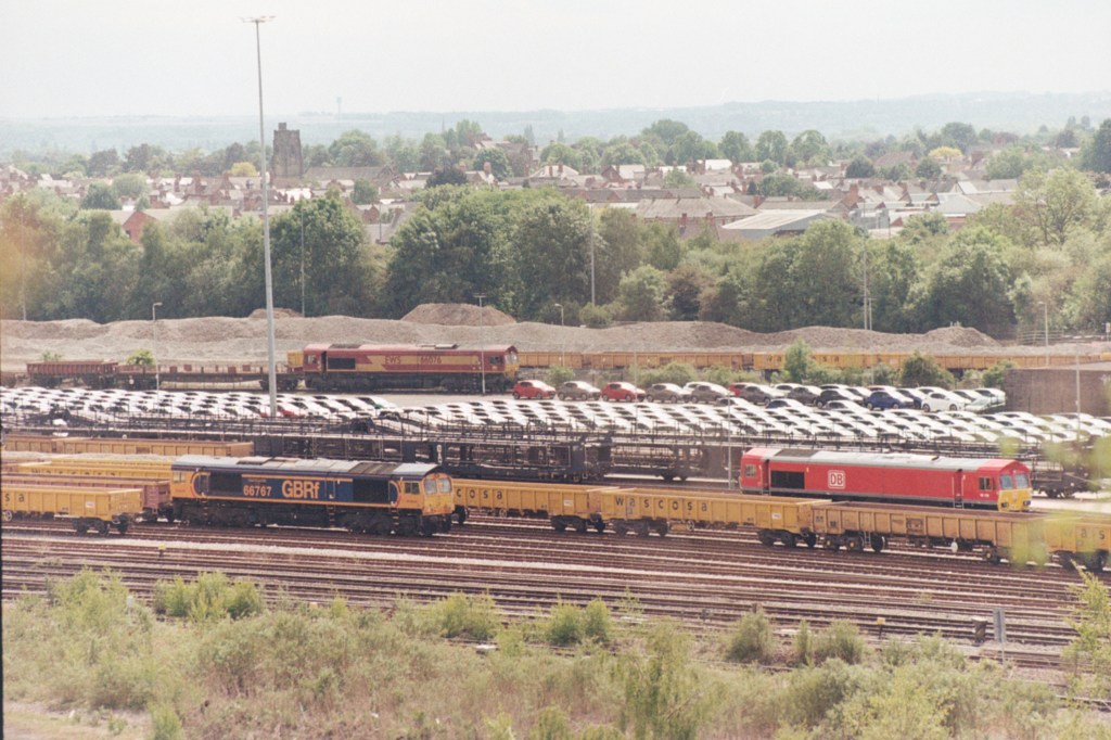
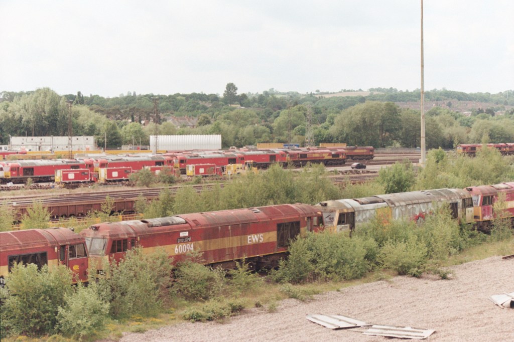
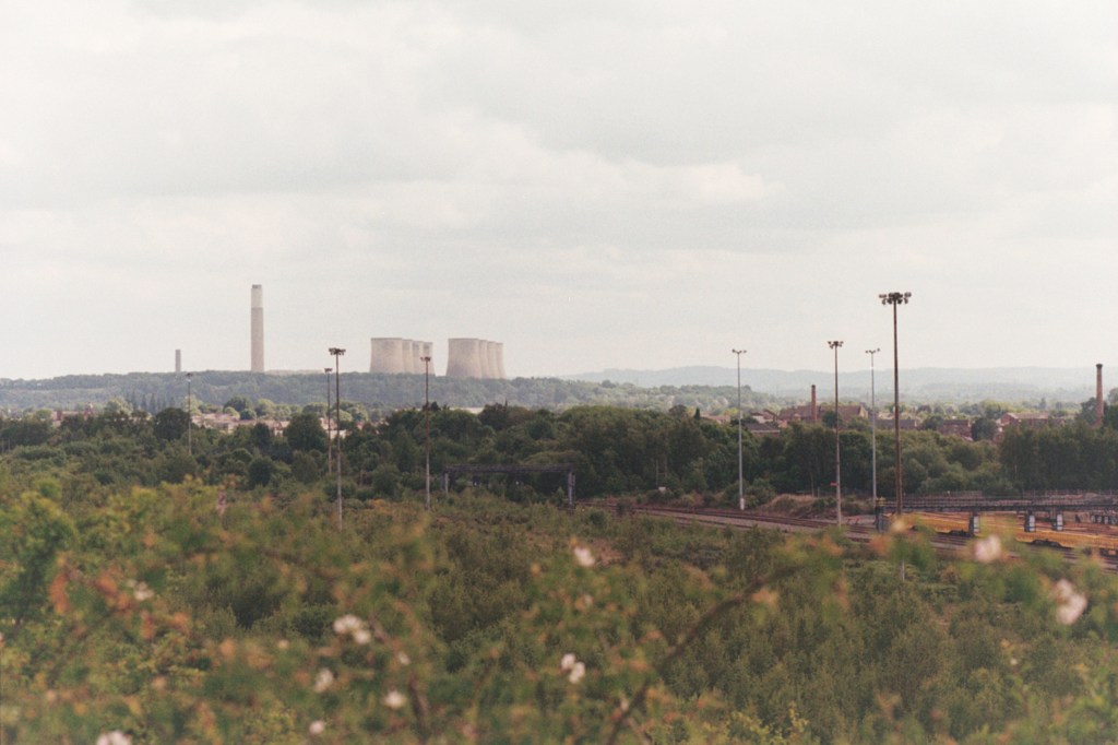
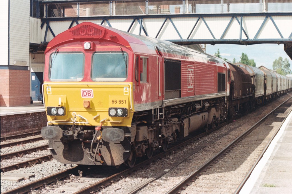
I was overlooking the Toton marshalling and freight yards. A hive of railway activity with locomotives slowly moving north and south, vying for position. Every so often a long freight train pulling through. Immediately below two peripheral sidings were the final resting places for scores of redundant diesels, just waiting to be scrapped. In a way quite a moving sight but somewhat inevitable given our rejection of railways as a means of tackling our multitude of problems. But beyond, the activity suggested that whilst the rail freight business might be down, it wasn’t quite out. And the only reason I am talking about this at all is that the site contained the largest selection of Class 66 diesel locomotives in one place that I have ever seen (and they weren’t all red) **
A colouration of Class 66s.
The end of the line at Toton
I could have sat and watched the activity at the Toton yards for hours more, but it was time to go back to West Bridgeford.
I walked back south on the low ridge (which I guessed was artificial) and just as the yard was coming to an end, with my route out of the reserve to the left, I looked up. On the horizon, perhaps a mile or two to the south, the huge cooling towers of the old Ratcliffe on Soar power station reared above the low Nottinghamshire plain. It occurred to me that it might be the last time I would ever see it, it having been in my line of sight on hundreds of occasions since the mid 1960’s. Coal powered and out of date, it nevertheless always had an uplifting, cathedral like and overwhelming appeal. But, despite the unaccountable nostalgia, it must go and for the last time I took a photo.
Fair ye well Ratcliffe on Soar.
After navigating through the usual late afternoon urban congestion, I found myself driving back past the cricket ground. It was heaving, which was a surprise. The radio had been on and suddenly they had gone over to Trent Bridge for an update on the cricket! England v Zimbabwe one off test match. And at that moment I was there, but not. How could I have missed this opportunity? I reflected that I could have spent the day in the sun watching the great game, but then, just think what I would have missed if I had.
Part of the appeal of visiting the highest points of Britain’s counties (and subsequently Unitary Authorities) was the possibility of finding new places of interest, whether historic, aesthetic or geographic. Before I say more on this, I need to be clear that Nether Hall, the highest point in the City of Leicester, is none of these.
I was on my way to Nottingham for a very important engagement. Having left the A1 and then got as close as a field away from the highest point in the county of Rutland (Cold Overton Park) I was back on the road and heading towards Leicester’s north-eastern suburbs. After crossing into Leicestershire, the Cold Overton Road became the Oakham Road. I passed through the small village of Knossington, and then driving by instinct over intelligence, sometime later I was on a narrow road just past Marefield and in a rural landscape that was reminiscent of a time before the invention of the car.
The road traversed a grassy field with long horned cattle nonchalantly observing my progress. Just half an hour earlier I’d bottled out of crossing a field (on foot) to reach the top of Rutland, due to the presence of a herd of modern industrialised cows, but this lot looked so benign I would have been happy to have got out of the car and stroked them.
At the end of the field I passed under a magnificent old red brick railway bridge, clearly abandoned. I pulled up just past the bridge and spent a few minutes scouting round the structure and taking another look at the recumbent cattle. There was no obviously legal route up the bank and onto the old track, although breaks in the fencing indicated that to get there might not be impossible. I returned to the car and made a mental note to check the location’s heritage at a later time.*
Bridge to nowhere – Marefield
The narrow lane continued through an equally appealing rural landscape. At a junction I headed south (I was aiming for the A47) but my precise location was indeterminate. I passed through Tilton on the Hill and then did a right onto Tilton Lane. Why, you might ask, am I banging on about the route, when I ought to cut to the chase and just post a picture of Nether Hall. Well, it’s because, having thought I knew Leicester and Leicestershire well, I genuinely wasn’t expecting to find myself on a gradually rising road which, halfway along, suddenly broke cover onto a ridge with unexpectedly delightful views to the south and north. It felt more like being in parts of the Yorkshire Dales than the East Midlands.
The reason for this topographical anomaly is a layer of Dyrham formation sedimentary rock that projects like a Cornwall shaped peninsular into and above a lower layer of Charmouth mudstone (another sedimentary rock). Everything ultimately boils down to geology (why are there wars?), and in this case it has produced a small nugget of essentially English countryside. Not having enough time to stop and explore a little I filed it in my memory bank (or as Christopher Plummer, playing the part of Wellington, said in the film Waterloo, “It may surprise you to know that I saw this ground a year ago. And I kept it in my pocket.”). I may return.
Eventually gaining the A47 I drove directly west and reaching the suburb of Bushby, turned right onto Station Lane and then left onto Scraptoft Lane. At an imposing and impressive looking Georgian pub (the White House – now a Wetherspoon’s!!) I took an immediate right and passed through Scraptoft. I still wasn’t yet within the Leicester City boundary, but this name took me back nearly five decades.
Between 1976 and 1979 I studied Geography at Leicester University, and Scraptoft, despite never visiting at that time, was a place that I had heard of. On looking this up a while later I discovered that in 1976 it became one of the campuses for the then Leicester Polytechnic. Now, there are only two reasons why I would have known about it then. Either some of my pals, the footballing lot, had played the Poly’s footballing lot, or possibly, and sadly more likely, some of my other acquaintances at the time, who grew up on the Stretford End terrace at Manchester United, had gone to a disco there and enjoyed a Saturday night ruck. That was a very long time ago, and another life. In 2003 the hall was sold for development. What’s new?
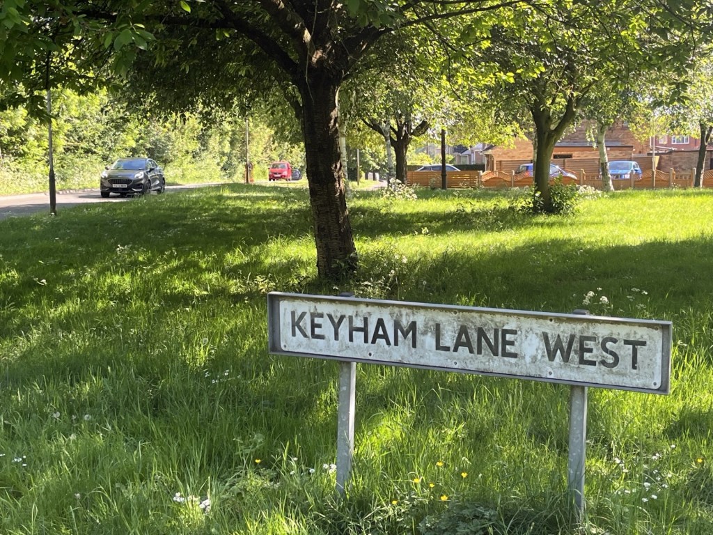
I was close and a short drive north on Hamilton Lane and then left onto Keyham Lane West, where I pulled over. I was back in Leicester…. just!
A small “green” occupied the south side of Keyham Lane West, beyond which lay some modest but reasonably attractive housing. The border (for want of a better word) between Leicester City and Leicestershire lay on the east side of Hamilton Lane, and thus the objective had been achieved. **
The sign could do with a wash. The high point is just a few metres to the left
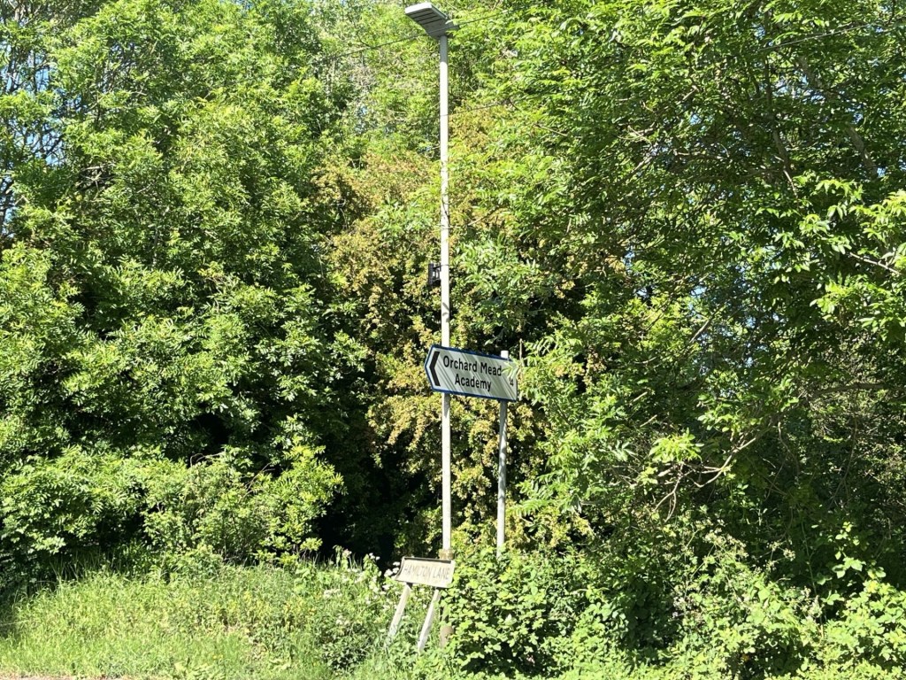
Another sign in distress. Just over the border in Leicestershire – Hamilton Lane
Time was getting on. Any thoughts of reaching the highest point in Leicestershire (Bardon Hill), evaporated as the traffic moved at a snail’s pace around the northern ring road. But the names were coming back to me. Humberstone, Thurmaston, Glen Parva and Anstey. I’m not particularly nostalgic, but I loved Leicester in the 1970’s, and having visited it again two years ago, I still do. It has a positive buzz and an attractive town centre. And, hey… I saw some of the best bands there back in the day (The Jam, The Clash and the Live Stiffs tour, to name check just a few).
As I say, no scope for nostalgia here from me (ha!). I had an appointment with my brother and sister-in-law in the Test Match pub in West Bridgford. Back in December 2024 I had sat in the Copper Pot in Leamington Spa and watched one of the most exciting games of football I’d seen in ages. Spurs had ripped Manchester United to shreds in the first half, but only just managed to survive after their goalie (Fraser Foster) made two howling errors and clung onto a 4-3 win in the quarter final of the League Cup. The next day I visited the highest point in Warwickshire. Well, a few weeks later Liverpool thrashed Spurs at the Lane in the semi-final, and after Spurs were knocked ingloriously out of the FA Cup, all that was left was the Europa League Trophy. Despite an atrocious second half of the season for both teams, Spurs and Manchester United somehow managed to get to the final in Portugal. And joy oh joy…. Spurs won!
I’d topped Rutland (nearly) and the City of Leicester, found a bit of countryside just east of Leicester that might call me back one day, and seen my team win a cup for the first time in 17 years. What more could an old man wish for? Oh, did I mention that my home team, Crystal Palace, had also just won the FA Cup? ***
*The old railway tracks at Marefield converge just to the west of Manor Farm. Unbelievably three stations lay within the area. A joint venture undertaken by the Great Northern and the London and North West railway companies in the late 19th century, it was primarily a goods line (Iron Ore, Coal and agricultural products) and several trains a day made journeys to all points south, north, east and west. By the 1960’s it had closed (like so many other lines). Today, with the exception of some old stranded redbrick bridges, you’d never know what a hive of industrial activity had once dominated the landscape.
Screenshot
The ghost of Marefield Junction
**Don’t be fooled. Peak Visor, which is a decent enough site, names Birstall Hill, further to the west as being the highest point. I think I can say with some certainty that it is not.
After the City of London, Rutland is the smallest county in England and sits pretty much in the middle. Which was handy for me, as it was just a slight diversion on my route to spend a night with my brother and sister-in-law in Nottingham.
It was mid-afternoon as I turned left off the A1 and started heading west across the county on the A606. The last time I had done this journey would have been decades ago, but other than a few sympathetically designed newbuild properties in the small town of Empingham, nothing much had changed.
Between Empingham and the county town of Oakham, the mass of Rutland Water flanked the road to the left. Until its creation in the 1970’s, by flooding a large part of the county, it’s probably fair to say that nothing much had changed in Rutland since the Roman occupation.
The objective was beyond Oakham to the west. I drove straight into the town and then came to a halt just short of the station. The level crossing gates had come down, and for the second time in a couple of weeks, in a completely different part of the country (Snodland), a red Class 66 diesel locomotive powered north with empty freight wagons dragging gracefully behind. *
After the excitement of the train moment (I already suspected that the rest of the day would now be a disappointment), I crossed over the tracks and carried west on Cold Overton Road. Leaving Oakham, the road continued up a shallow gradient for over a mile and until I turned left at Glebe Farm. Whilst it felt a little bit like a private road there didn’t appear to be anyone around, so I continued past a telecommunication aerial (always a good sign) to the end. I knew it was the end because there was a big farm gate dead ahead, and to the left another bigger gate preventing access to a concrete water storage facility. I parked up, looked around and went through the farm gate. A footpath sign gave hope.
Past the First Gate (I had hidden the car behind the fence)
The road continued onwards for a short distance beyond the gate, before opening out into fields on all sides. The first field, to the right, was unfortified, and I knew that if I just walked southwest across it, I would at get close to the top, but no further. For reasons I can’t quite pin down now, something about the field suggested private property, which it probably was, but in a rare moment of self-doubt I decided to reject the opportunity.
Looking south-west towards the top (my right to roam instincts let me down)
Instead, I tracked back along the line of the field to the south to where a footpath sign confirmed I was entitled to carry on, and at least to the point in the field just to the east of the trig point at the top. It was only going to be a three-minute walk but as I passed into the field, and on looking ahead, a rash of cows suddenly appeared (brown if I recall). Up until about twenty years ago I had never given a second thought to cows in fields. Around that time, and perhaps due to the deluge of news through new technology, stories were beginning to crop up about people being injured and killed by cows (whilst the numbers are relatively small, on average four people a year are killed). At around that time, and whilst on a short stroll through a field somewhere in the south, a herd of cows started moving towards me. At first, I gave it no thought, but their pace picked up and without trying to show panic, so did mine. At around 20 paces, the twenty or so brown heifers, or whatever they may have been, seemed to be getting very excitable, and I was beginning to fear the worst. By now I had reached the edge of the field, and whilst still not entirely sure of my fate, I chose the undignified plunge into the bramble thicket and trees that hid a small stream, rather than taking my chance on the open ground. Fording the stream didn’t appear to be an option, so I waited it out until the herd, no doubt disgruntled by their failure, slowly retreated back across the field, giving me enough distance to trot back to the entrance to the field and a liberating sense of relief.
And, with this historical encounter in mind, with just a hundred or so metres to the top of Cold Overton, I bottled it and slipped back to the car.
Cattle deterrent on the horizon.
So, I didn’t quite get to Rutland’s summit, but it was as much as I could do under the circumstances. Cowardice, or perhaps just sensible pragmatism, had got the better of me.
Apart from getting to Nottingham for six, I had one more objective for the day. Reaching the top of Leicester Unitary Authority. I turned left onto Cold Overton Road and continued west through what was left of Rutland (a small matter of about 200 metres), and then over the border into Leicestershire.
*A red Class 66. Hereford Station – Oct 2024 – Other colours are available
I arrived at Ashford International station on a small train. On leaving the carriage, the intention being to catch an onward train to Paddock Wood, the early warmth of the day had dissipated. As I waited on the desolate platform, a cold wind from the north knocked the stuffing out of me. Poor old Ashford. Battered by Brexit and then Covid, the last of the Eurostar’s left from here some years ago, and they ain’t coming back anytime soon.
After twenty minutes, by which time my fingers had gone an unhealthy yellowy white, and I was pondering on the wisdom of the decision to do this journey, my onward train arrived. As it sped west through Kent, I read that today was the day that Reform UK succeeded the Tories by taking control of Kent County Council. Well, good luck with that, I thought, before reassuring myself that I was, at least, going to spend part of the rest of the day in the Unitary Authority of Medway, a chunk of the world on the south bank of the Thames that had once formed part of the wider Kent (the summit of which – Betsom’s Hill – I had reached on my very first outing nearly a year to the day before, and also before I had decided to include Unitary Authorities within the scope of these investigation). *
At Paddock Wood I changed trains again, and shortly I was heading north, with the river Medway to the right. This route was entirely new to me. Despite having lived in the South-East for much of my life, somehow this area had eluded me. And very pleasant it was too! The short train stopped frequently, and it struck me that at some point in the future a walk along the banks of the river from station to station would make for a productive afternoon.
I was excited at the prospect of passing through Maidstone, a town I knew nothing about other than last year their football team had made impressive progress in the FA Cup. On arrival, the prospect on show was pitifully disappointing. No sign of the town beyond the tatty old warehouses and poorly designed modern flats.
Heading north out of Maidstone and towards Snodland (my destination for the start of my walk), heavy industry flanked the line, although at a distance the ridge of the North Downs stretched away to the east.
Snodland, for reasons I can’t account for, seems to crop up on the news, and on the sort of programmes made by middle aged male “has-beens” professing their love for our railways (I’m just jealous really). I had no idea what to expect as I left the quaint Victorian station and headed up a road leading west and towards the town. I had an Ordnance Survey map (OS Landranger 178) and had an idea of my route to Holly Hill, but I hadn’t expected to be taken over a depressing road bridge that spanned the miserably busy A228 road below.
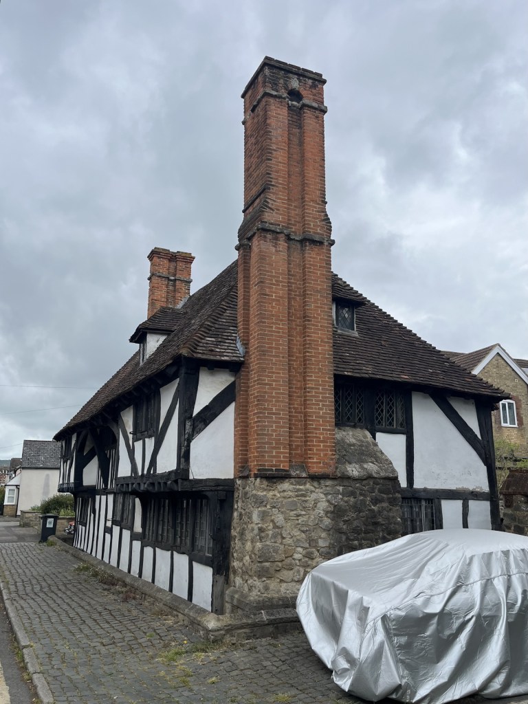
Having made it across the bridge, an even less inviting pedestrian path to the right (not a place you’d want to hang around in the dark) took me down to the start of the town, and a dead end which would, at one time, have continued to the station had it not been for its amputation by the A228. A few Victorian terrace houses, one having been a long-closed pub, lined the road on the left. A very impressive Tudoresque house stood to the right, with a very expensive car, covered to protect its identity, parked outside.
It was all downhill (or was it up) from here
These few buildings aside, I’m afraid to report that the rest of Snodland offered up nothing of interest. I walked up the High Road into the town, crossing another main road, and then after a few minutes had reached the end of Snodland and was onto Paddlesworth Road. Almost immediately this narrow and very rural lane took me out of the urban sprawl. I knew from my map that at some point soon I would find a footpath on the right-hand side and momentarily got excited when I came across a fairly new and robust looking metal kissing gate, obviously intended for public access. Disappointing then to find it strapped up with heavy duty padlocks, and thoroughly overgrown. What had been the intention? I’ll never know.
Best laid plans
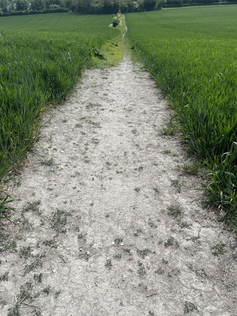
Further up the road, which, when a vehicle appeared, required one to back carefully into the hedgerow, a footpath sign to the right, and I was now off the road and following a straight chalk path up through the middle of a large field. Halfway up I noticed increasing evidence of broken pottery and other bits and bobs that indicated that at some time in the fairly distant past this area had been used as an early fly tipping site. Very Kent – now the beating heartland of rural desecration by organised crime.
The old straight tip track
At the top of the field a wide track to the left, flanked on both sides by enormous, recently trimmed hedges, pointed me in the direction of my destination. The land ahead rose towards thick woodland and somewhere beyond that was Holly Hill. The track took a while to navigate, and the recently trimmed branches proved surprisingly awkward to traverse. To my right I could see a very solid green metal fence with pointy bits on top, clearly intended to protect people like me from the unknown danger that lay beyond.
Beware of recently cut hedgerow because it’s sure to get you
Eventually I was free of the hedge track, and now on a more traditional country path with fields to my right. I stopped to take a look over the more traditional barbed wire fence. Beyond, and stretching for hundreds of metres, was evidence of what must have been a huge chalk quarry (or pit). I have a certain thing for chalk pits. My second year Geography degree dissertation in 1978 had been about the chalk quarries of south Croydon. I mean, you know, someone had to do it. And at times, whilst also trying to earn a few bob working in the electrical department of a now long-gone department store, it was quite enjoyable cycling up and down the steep terrain, with a camera and notebook, trying to figure out what was what and trying to formulate a suitable narrative. I even ended up being invited into a Coca Cola bottling factory on an industrial estate which occupied one of the old quarries, and being told about the danger to life and limb of their employees from the kids on the estate above who specialised in throwing rocks down into the quarry after school. This of course was a very long time before the internet and PCs. Academic research was confined to whatever the main Croydon library had to offer, which was probably more than I could have expected. Once I had written up my opus magna it had to be professionally typed up (and blooming well bound), at a cost that left me in debt for some years to come. Once submitted, that was the last I saw of it. It became the property of the University!! Huh! And there was no feedback, or indication on whether it had any merit.
Many years later I came across a small exhibition somewhere in Croydon, which seemed to me to cover some very familiar territory (if not the copyright of the University). It piqued my curiosity. Where had my dissertation ended up? I wrote to the University and asked if I could be sent a copy or at least have access to it. The reply came – they no longer had a copy! Huh – again! Along with all the effort, expenses and the £20 for the typing, I felt slightly robbed. Am I straying a thousand miles from the subject matter here? I’m over it now though. In 1980, and not to be caught out again by the typing scam, I obtained a cheap typewriter and taught myself to type. Never very proficient, and for many years I felt that all the effort had been a complete waste of time – until, well, until the modern world intruded and the keyboard was now the only thing on earth of any value. Bingo! Unintended consequences. **
Towards the Quarries
But none of the quarries on the scarp face of the North Downs in Surrey were on anything like the same scale I now saw before me. As I contemplated this scene I could hear the sound of excited dogs somewhere ahead. A kennel I suspected. A little ominous too. Carrying on up the path, I became aware of movement quite a distance ahead. A young woman was coming in my direction, being, from what I could tell, dragged along by a dog the size of an adult pig, and with the appearance of a Baskerville hound. It had already been the driest Spring on record, but the amount of slobber sloshing from this abomination’s mouth would have been enough to rejuvenate the driest of streams. There certainly wasn’t room for the both of us to pass and so; to give myself a chance, I climbed high up the embankment to my left and uttered a cheery “afternoon” as they passed. I assumed that the dog was a temporary inmate at the nearby kennels which were at the end of the path, but to the person, somewhere, who has created this breed, whatever it was, and to the people who purchase similar, please stop!
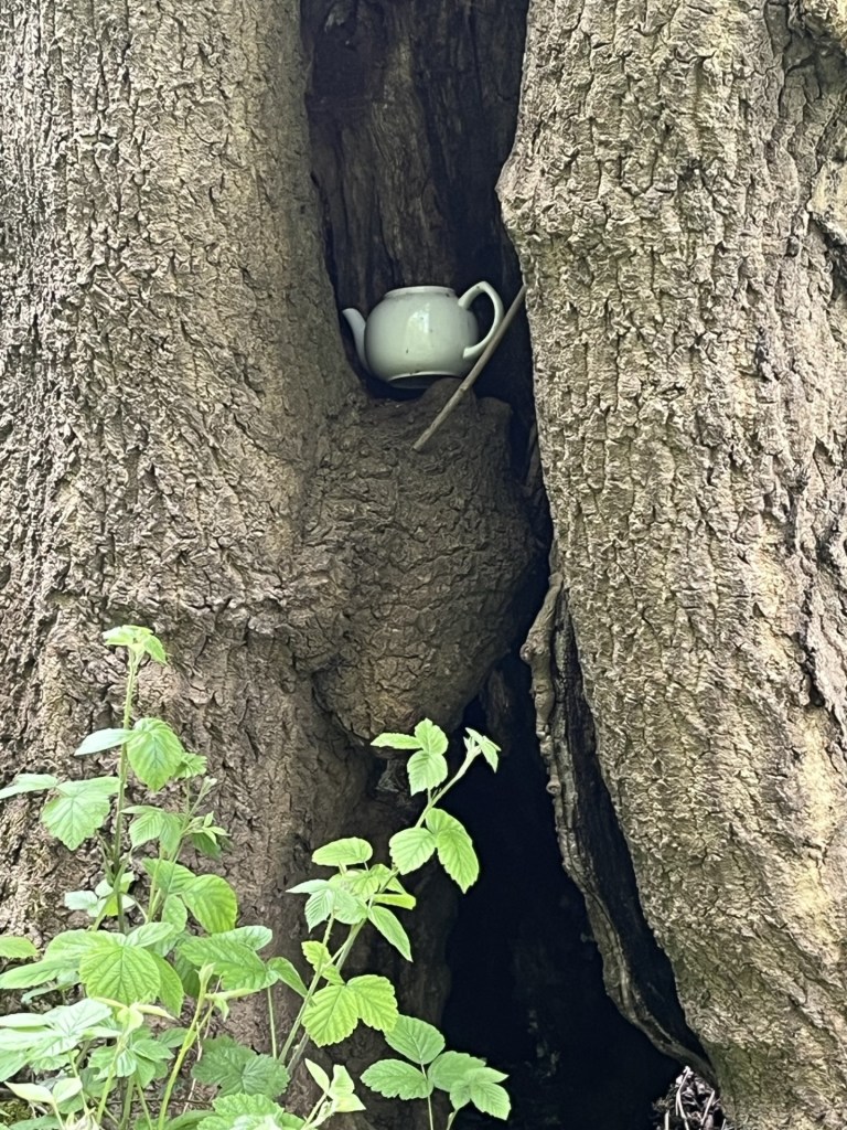
At the top of the path (just to confirm I survived the dog moment unscathed), a track led left and right, but I chose the gate directly ahead and a path that started to ascend up through some woods. To the right, an old derelict house sat in amongst the trees. A sign attached to a fence said Keep Out – Property of the Blue Circle Cement Company, which explained a lot. The path continued through beech and birch trees in the first flush of new growth. A teapot, naturally, sat wedged in the cleft of one of these trees. Art, a tiny house that tiny things lived in, or just fly tipping, it was hard to tell, but in truth it looked quite at home in the tree.
Brewing Up
At this point the path began to head downhill. Welcome to a degree, but with the caveat that all height lost meant more pain later. I emerged into a large glade, surrounded by pines and other varieties. A dirt road passed east to west, and a solitary dead tree stood in the middle of the glade sporting a large sign explaining that something was private property. Given that there was no sign of any fencing it was hard to determine what this instruction referred to, other than it might have been the dead tree. I had no plan to climb it.
I didn’t get the message
I chose to follow the track that ran westwards, and a while on did indeed come across a fence to my left, and a large field of scrubland that stretched up to the north. In places the last primroses of Spring clung to the edge of the track. Consulting the map, I could see that somewhere at the top of this open ground there was a footpath that led into some woods that emerged into bigger fields which would lead up to the top of Holly Hill, and so it was onwards and up.
Up the scrub and looking towards the Medway
It was a fair old hike to the top of the scrubland (for an old person anyway). Having reached the top, I worked around the dilapidated fencing and came across a similarly dilapidated stile. Anyone who does a bit of recreational walking in the country will know that slightly deflating feeling when coming across an unmaintained stile or gate. It was patently obvious that this location was rarely ever troubled by the public and had not been interfered with for some weeks, or months. Chest high nettles had grown with vigour on both sides. I considered going back down to find a better route, but that felt slightly defeatist so instead I took some minutes preparing to climb over; grateful that I wasn’t wearing short trousers. With a brave heart and hands held high I progressed purposefully and made it without incident.
Travelling in stile
Now I was in a small glade. The remnants of a path took me so far before evaporating in a jungle of more nettles and enthusiastic young brambles. The land ahead rose sharply up through dense woodland. Somewhere within this tangle of nature there was a legitimate route, but it was no use. I began to pick my way up as carefully as possible, trying not to brush skin on anything that represented a threat, which was everything. This was hard going and I’m not the nimble gazelle I once was. Trying to pick the least worst route took ages, and even the least worse routes involved repeated trouser snagging. This was a very short climb, but it took me about twenty minutes.
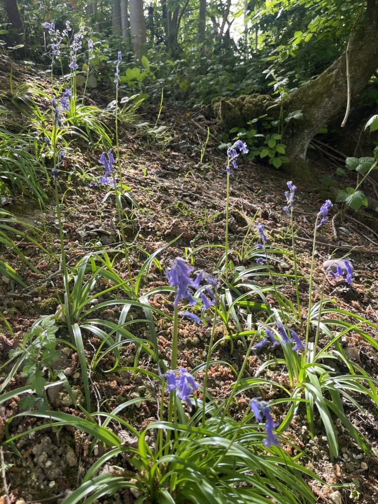
Don’t be deceived – These bluebells were lethal
At last, and to my great relief, I was out of the morass and standing at the edge of a large agricultural field. Disorientated, I had no idea where at the edge of the field I was and the map couldn’t help me, but I knew that heading north and keeping to the edge of the field would get me there eventually. A while on and to the right, another less than useless stile indicated where I ought to have emerged.
Somewhere in a field, somewhere still in Kent
Keeping to the edge of the field eventually I headed directly across rough ground and to a hedge line that I hoped was the top. It wasn’t. A settlement a short distance away confirmed I had another large field to go. By now I was certain of the objective. A large old tree stood on its own in the field beyond. I aimed directly at it, despite a minor uncertainty as to whether I was trespassing or not. Near the tree a large area of the field, about the size of two football pitches, had been turned over, for no obvious reason I could think of. I guessed that some sort of greening subsidy was being used to make something of this otherwise neglected field.
A few steps into Medway
To my north the field was lined with dense woodland, where, if I was to believe some of the literature online, the highest point in Medway lay just beyond the hedge line. The thing to note about this endeavour was that whilst almost the entire field area, stretching to the south, was in Kent, for reasons that simply can’t be explained, expect by the officer who plotted the boundary, the county line (not to be confused with County Lines – which is a completely different pursuit), makes a triangular shaped intrusion into the field. This Medway intrusion must be very confusing for the landowner and must lead to inter authority bureaucratic squabbling over incidents of fly tipping.
The Medway Unitary Authority salient (in orange). Kent/Medway boundary marked by dash/dot black line
I sniffed a bit along the hedge line at approximately the location that PeakBagger had indicated was the “top”, to see if there was any sign of higher land within the woods, but it didn’t seem as if there was, and looking back at the field I had crossed, despite being something of a plateau, I was fairly convinced that the land past the tree, and where the field had been turned over, was marginally higher than anywhere else. ***
Somewhere, just to the right of the tree, the top
Having, one way or another, crested Medway UA, I certainly wasn’t going to battle back down the way I had come and already had an alternative route in mind. Back down the field a bit, and to the east, a decent enough gate led the walker into dense woodland, and as I passed into its embrace, I was back in Kent.
A short walk into the woods and the path split in two directions. One carrying on with the contour and the other falling away down a slope. At the junction I beheld a quintessential English country landmark. None other than a plastic litter bin overflowing with plastic bottles and dog shit bags. There was obviously a good reason for it being there i.e. the compulsion of a large minority of people to drop their drinks containers and dog shit bags on the ground, rather than the inconvenience of taking them home. So, cause and effect, some kind heart/s had installed the bin to limit the impact. Bless them, but poor sods too, having to come out here probably every day to empty, rinse and repeat cycle. Depressing really.
Where the path diverges. Dog shit marks the spot.
I opted on the downhill route, on the basis that it was downhill and I rather desired to get down sooner than later. Not as easy as it looked. Quite a lot of branches blocked the way. Not enough to prevent further progress, but I hadn’t done my stretching exercises in the morning. I was now.
And then the trail took a much steeper dive. The ground was bone dry, but I was going to need to take some care. At this point I noticed what appeared to be lumps of iron sticking out of the ground, and they spoke of instant disaster. I also noticed to my left a rope that fell away along the side of the path. What was I getting myself into? It slowly began to make sense. The foot wide lumps of metal, hammered into the ground every couple of feet, were there, along with the rope, to aid the walker, or in this case, climber. In wet conditions I am certain that the metal steps would be extremely useful but covered in dry dirt and a lot of vegetation, they now made for an almost inevitable trip feature. I took the greatest care of going down, and it continued down for some minutes. Eventually, uninjured, the path exited the woods at a small road.
Believe me, every one of those steps hides a trip hazard
Walking up the road it soon bore to the right. It felt logical to follow it, but just to my left a footpath sign and a sturdy kissing gate invited more interesting countryside exploration.
The gate took some negotiating. It clearly hadn’t been used in a very long time, but once in the field, and having looked at my map, a footpath could just be discerned heading across the large, tatty field. Overgrown, largely with thistle type plants, this part of the stroll was particularly unpleasant, and I now regretted not having stuck to the road. Eventually this annoying part of the journey ended, with the path dropping back to the road through a thicket so thick that a machete would have come in handy.
I followed the road for a while and occasionally looked at the views towards the north and east. Across the river Medway to the east and more evidence of vast chalk quarries hacked out of the North Downs.
Into the Medway
The road became more of a dirt track as it entered the top of the large field with dense woodland to the left. The track then turned downhill, heading southeast until reaching Ladd’s farm at the junction with the Pilgrims Way. The farm buildings, apart from long ago extensions here and there, remained remarkably, and you could say charmingly, unaltered since the 19th Century.
Ladd’s Farm
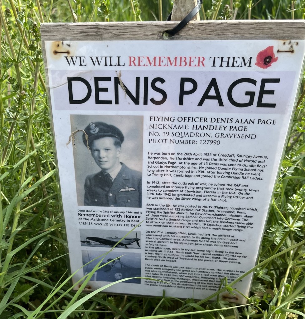
A small road (Ladd’s Lane) ran roughly south, almost directly opposite the farm, but a small sign pinned to a lump of wood at the side of the field opposite caught my attention. Another sad memorial to the dead of previous wars. This time, Denis Page, Pilot Number 127990, killed when his Mustang fighter crashed into the nearby field. He was just twenty!
This poignant story was counterpoised by the huge field opposite, where a yellow swathe of rape flowers lay like a carpet over the chalk, and where beyond a long low chalk cliff formed the base to a small community above.
The artificial chalk cliffs of Halling
With the field to my right the lane started to head east and back towards Snodland. In the late afternoon, and apart from the odd vehicle coming out of Snodland, it made for a pleasant end to the walk. Eventually the fields gave way to the heavy-duty green metal fencing with pointy tips that I had encountered earlier in the walk. Clearly intended to prevent access to the huge old quarries and pits lurking beyond.
The road eventually reached an area called Holborough where, before reaching the A228, a large newish estate with pond features created on land reclaimed from the old quarries. As modern estates go it looked pretty good. A path headed south along the backs of older housing, which at least meant avoiding contact with the dual carriageway, and I was soon back in Snodland and then the station, just as a freight train pulled by a class 66 locomotive thundered northwards (sorry, it’s a niche sideline).
I had twenty minutes to wait for my train back to Paddock Wood, but that was okay. My son rang to touch base. When I explained the day he expressed some interest, which was kind! It had been an unexpectedly excellent seven mile walk in an area I knew absolutely nothing about, but which I now felt I knew a lot more.
Snodland Station – next stop Paddock Wood
* Medway Unitary Authority covers the area of Rochester, Chatham, Gillingham and the Hoo Peninsula. Some years ago, when I was a tad younger and fitter, I wasted some time on my bike sticking as far as I could to the coast, and if you are desperate for more of where this comes from these links will take you to the north.
** In a moment of extraordinary serendipity, as I was coming to the end of writing this account, I was also multitasking, having decided to reorganise my clothes draws. I started on the bottom draw, having completely forgotten what it contained, and having not opened it in some years. No clothes, but instead random “stuff” that included a plastic bag. I felt in the bag and the first thing out was a cardboard envelope, in which, and to my amazement, a draft copy of my dissertation. For the next hour I sat and re-read it. In parts it was naive, and in truth (I had had a very Comprehensive education) at times the spelling and grammar left a lot to be desired. I suppose I was only 20 years old at the time, yet despite these minor self-criticisms, it made for an interesting and informative read. At the end I considered that one day it ought to be possible to rejuvenate one of these old chalk quarries as a leisure water park. And so, when looking on Google maps and at the area to the north of Ladd’s Lane – St Andrew’s Lakes. A deep water “aqua” leisure park, built into an old chalk quarry some years ago. I had missed a trick!
Kenley Chalk Pit 1978 – Car free adolescence
*** This is the point that Peak Bagger claims as the top, and I believe they are correct. On the other hand, Peak Visor, which is another clever looking site, places the top of Medway a bit further to the north at a place called Round Hill, which, according to the BGS App, falls short by 10 metres.
The day after reaching the top of Bournemouth, Christchurch and Poole (UA), and a debatable claim to the highest point of Southampton, I awoke in Southsea, and to another sparkling but breezy day. I had some hours to kill before shifting back home, and so, with the couple I had been staying with, took a long and invigorating stroll along the seafront to Southsea Castle. With small, middling and large boats, vessels and ships slipping in and out of the channel, and across to the Isle of Wight – like a south coast version of the Bosphorus – there was so much going on it never crossed my mind to take a photo.
Over a coffee in the attractive Southsea Castle cafe, I tediously blabbed on about recent adventures and reaching the highest points of counties, but that it had now come with the additional complication of the Unitary Authorities. I think it was just about then that they started getting twitchy about when I was actually going to leave. “So,” I asked, “how do I get to Portsdown Hill?” At which point I noticed the life force leaving them both. Almost without thinking they told me it was above the main hospital and gave me what they claimed to be easy and accurate directions.
After bidding them farewell I headed out of Southsea, the same way I had come the evening before, this time without any major traffic jams. I reached the M27 which I crossed, and despite confidence in my directional skills almost immediately ended up on an industrial estate that had me befuddled for over twenty minutes. I eventually discovered the tiny road out and up, more by luck than design. I was relieved to have escaped the labyrinth of small roads, not least because I suspected that the more observant bystanders in the area were concluding that I might have been casing one or two of the units in the pursuit of criminal endeavour.
I knew my way now. Continuing uphill I came to a roundabout and turned left. Almost immediately I suspected an error, and at the first opportunity turned right into a housing estate. Actually, I thought, if I continued up, I might get to the hospital (one of the primary reference points suggested by my friends). Despite the grid pattern estate roads, one way and no entry system had me in another pickle. I surrendered, pulled up and consulted the phone. No, there was no way to get to the hospital without going back down and out. The road I wanted was just above me. I could see it. Vehicles were heading up and down the road cut into the chalk.
Eventually the estate spat me out and I was, at last, on track, passing the hospital and heading up the steep chalk incline on Southwick Hill Road (which judging by its appearance must have once been a long cliff butting up to the sea), and to the top. I crossed over a roundabout heading west and then followed the road (the brilliantly named James Callaghan Drive), for a mile or so before it started to lose elevation. The day before I had stayed in the Nags Head in Lyme Regis, which in 1964 had entertained Harold Wilson. For younger readers, and any wider audience, most will have heard of Harold Wilson, but not so many perhaps of his successor as Labour leader, and then Prime Minister, James Callaghan (Uncle Jim). Two socialist PMs in two days. Maybe this could be a new hobby – seeking out places honouring socialist Prime Ministers (it probably wouldn’t take too long). Callaghan had been born in Pompy. He lost the 1979 election to the Tories. I had voted Labour but to no avail (I was just 21 and it was my first time). I graduated the same year, and (I won’t mince my words) along with millions of others, spent the next three years either out of work or in temporary employment, primarily due to the slash and burn policies that were subsequently implemented. Nice to have a road named after him, I thought, but I had to press on. I was at Fort Southwick, but that wasn’t where I wanted to be. My friends had been quite specific. The highest point was surely Fort Widley, just above Queen Alexandra Hospital. Who was I to argue with the locals? I turned the car round and then set off back the way I had come, and at the roundabout continued over and, soon enough, came to a turning into a small road that I knew was going to get me to Fort Widley.
It was a busy spot. I left the car and walked past the burger van and into some overgrowth where a path hinted at further progress towards the top. The huge 19th century fort came into view, but despite a scout around to left and right, further progress seemed impossible as the entire massive fortification was protected by a modern metal fence with pointy bits on top.
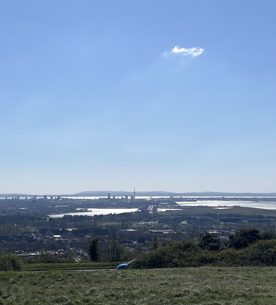
I strolled back to the car, satisfied that as far as I could, I had reached the top of Portsmouth. Buying a coffee (a very good one as it happens) from the Route 66 Burger van, I sat and contemplated the view for the first time. It was entirely familiar to me. Last summer I had camped in West Sussex in the pursuit of Blackdown Hill, the highest point in that county. On the evening of my arrival, I had climbed Beacon Hill a few miles to the south. At the summit I had taken a photo looking southwest towards Portsmouth.
Looking towards Portsmouth and Portsdown Hill from Beacon Hill – August 2024
Now I seemed to be looking at the same view, but just a lot closer. Magnificent. The Solent, picture blue, with the Isle of Wight basking offshore. There was no sign of either of the royal white elephant aircraft carriers in the harbour, which was just as well as on the occasions I have seen them in the past I have just got upset at their sheer expense and lack of justification.
The infamous, In My Imagination Incident
Time to head off, but not before a photo to record the moment
A closer view of Pompy – From Widley Fort
I was out of town and onto the M27 quick time. Heading east the road began to take a slow sweep to the right. I recognised it immediately. The last time I had driven this way the radio was on and, at this point, up popped the then Prime Minister Liz Truss, giving one of the most baleful resignation speeches ever (beaten only by her predecessor Boris Johnson in its lack of sincerity). She had indeed resigned!! I had laughed for at least the next five miles. What on earth would Uncle Jim have made of it all?
The story should end now, but there is a final twist. At home, and with the benefit of technology, it became clear that Fort Widley was less of a height than I had thought. It seemed that my friends may have sent me on a fool’s errand. Where then was the highest point? My luck was in. Getting somewhat lost on the Portsdown Hill ridge I had, as mentioned above, inadvertently arrived at Fort Southwick, which, by a few metres only, turns out to be the highest point. Phew! I hadn’t stepped out of the car and attempted the short walk to the actual highest point, which seems to be to the east of the fort, but I think a drive was enough to make do, and the photo I would have taken, was likely to have been very similar to the one from Fort Widley. It would have to do, for the moment. If I return to Portsmouth, which is probable, I’ll get it right.
Available options. So, you can either read this relatively short tale, or, if it’s entertainment you’re after, just skip to the bottom and watch the entirely unrelated 3-minute YouTube video.
On my way to Portsmouth, and a couple of hours earlier I had pulled into a layby at the top of Corfe Hills, the highest point in Bournemouth, Christchurch and Poole Unitary Authority.
I was now heading east on the M27 having joined it after a pleasant drive through the New Forest, an area I hadn’t been to in decades. I knew my objective. Bassett Avenue, just to the south of Junction 4 on the M27, and according to the internet, the highest point in the Unitary Authority of Southampton. It would be an easy drive-by that wouldn’t trouble my progress for the estimated 5.30pm arrival at friends in Southsea.
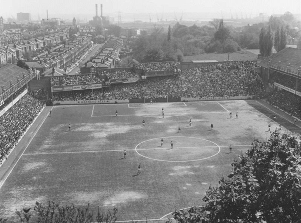
The traffic was beginning to increase. I guessed that the rush hour was starting. I know almost nothing about Southampton, other than the old football stadium was the eclectically shaped The Dell, on which the mercurial Matthew Le Tissier plied his trade, and regularly tonked them in from miles out of the box. I had a vague memory of passing through the centre of town sometime in the early 1980’s, but that’s as far as it went.
The old Dell stadium. I did not take this shot!!
And I was about to not find anything more about the city on this day either.
The traffic slowly but inevitably began to slow and then grind to a virtual halt. Road work signs began to appear at around junction 2. It wasn’t time to panic; yet. I’d noticed that traffic in the inside lane was moving with a bit more fluidity than mine (the middle), but it was too soon to be thinking about pulling over. I stayed in the middle lane but then noticed that the outside lane was doing a lot better, and so did the logical thing and pulled to the right. I didn’t need to be fouling up the middle lane for the locals after all.
When the traffic in the middle lane started to pick up speed, and the traffic in mine began to slow down, signs began to instruct all to stay in lane. Oh boy, this was going to make it more complicated, but there was still over a junction to go, and the road works couldn’t go on forever. Even if they did, I’d just have to pretend I hadn’t seen the instructions and do a bit of lane dancing (just like everyone else!).
Approaching junction 3 and it all went Pete Tong. A solid barrier suddenly appeared between my lane and the two inside lanes (I can’t recall if it was a “smart” motorway, in which case make that three). The lane diverted to the right and now I was moving at less than snail’s pace in the outside lane of the westbound carriageway. Quite disconcerting in itself and made worse by the barrier that made any prospect of a lane change to the left impossible.
The stop start momentum was beginning to take its toll on both my Achilles. I’d already been driving for some hours, and this wasn’t conducive to maintaining the positive vibes. And then, bit by bit, the signs for Junction 4 began to appear. I began to think that my goose was cooked, and of course, by the time I had edged past the slip road, it surely had. And that’s when the traffic stopped. A minute went by. I’d been in a similar situation a couple of years earlier, on the M25, and recognised the modus operandi. I switched the engine off.
When I had stopped on the M25 around 7pm a couple of years earlier, somewhere to the west of Potters Bar, I switched off the engine, recognising that it was going to be a while before we all moved again. After an hour I got out of the car and spoke to other entrapped road users. There had been a major crash a mile down the way. It was going to be another hour or so. Fair enough.
Another hour or so, and it was now going to be 11pm. Not great news. I still had another two and a half hours’ worth of driving after we eventually got clear. I tried to sleep. Impossible given that all I was thinking about was getting home, and the constant noise of traffic in the opposite direction. I may have eventually nodded off for a bit but was woken by the increasing cold, and chatter from just outside the car. A couple of mechanics from a nearby van were trying to get the huge gas guzzler next to mine started after its battery had gone flat from keeping the lights on, and no doubt the heating and a multitude of gadgets. A lesson learned perhaps, but the lesson I was learning was that from now on I was going to always keep a sleeping bag in the car.
At just before midnight, the helpful informants in the nearby car (they had been on a lovely long weekend in Liverpool, and were just two miles short of home, which made me feel worse for them than me), bore the very depressing news that the latest estimated release time was now going to be 6am! I can say in all honesty that up until that point I had retained some sympathy for whoever had been involved in the incident ahead, but now my shallower side surfaced. I said nothing but got back into my car and started to mull over what sort of irresponsible driving had contributed to my entrapment. Lane dodging at speed, tailgating, using a mobile phone, drink or drugs – they all met the threshold, with the lane dodging and tailgating in particular being rampant on the M25. I settled for a combination of all the above, plus a random other, but it wasn’t going to get me to sleep. Even if I did get any sleep, I wasn’t going to be in great condition to drive on if woken in the hazy dawn.
Unexpectedly, twenty minutes later, police officers and highway operatives were walking towards us. Maybe they were bringing water and some biscuits. Instead, and to everyone’s relief, the good news was that we were being turned around, from the back, and heading west to the previous junction. It took a while, and another vehicle in front was going nowhere, having also drained the juice. Once pointing in the opposite direction, we were each instructed to drive at no more than twenty miles an hour, which seemed eminently sensible given how disorientating the situation was. But guess what? If I said that one in three of the returnees ignored this instruction, and bolted off at fifty plus, would you believe me?
Once I eventually rejoined the M25, an hour and a half later and south of the river (this will only make sense if you know east London, but the Blackwall tunnel was also closed due to an accident, with a consequential diversion further towards central London and then back out again), I was a frazzled bunny. An hour on, and within ten miles of home, the ultimate kick in the bollocks. My road was closed, with a diversion to the east and through miles of deer strewn country lanes being lashed by wind and rain. It almost finished me off.
Fortunately, because by now I was totally wired and knew that sleep was a million miles away, when I eventually arrived home, sometime around 3am, there was a large glass of red wine calling out to be quaffed. It was, and minutes later I was gone. I learned a lot that night. The next day a news item mentioned the closure on the M25, with some out of focus images. Multiple vehicles involved. No-one seriously injured (I was relieved). Multiple tailgating most obviously. There was no mention of the emotional carnage for the hundreds of others. If something similar had been on the railways it would have been a major incident and would have received national coverage and scrutiny. But it’s okay. It’s just the roads. It happens every day and we don’t care.
Back on the M27 and forty minutes had passed by. At least I had the sleeping bag in the back. All the traffic in the two inside lanes was moving relatively smoothly but I’d long since given up any ambitions on reaching Bassett Avenue (ha!). Eventually, bit by bit we started moving again. Any movement was now a relief. Soon I passed a stationary vehicle squeezed tight to the left barrier. I already knew I was going to see something like this. The car had just broken down, nothing more. No-one to blame but another hour of life lost to the roads.
And so I missed out on the highest point in Southampton and have since rationalised that it will be quite a while, if ever, before I come this way again. It had gone unnoticed by me, but later, upon inspecting the map, the A33 on which Bassett Avenue lies, then becomes the A27 northbound and runs over the M27 on an overpass. If the M27 had passed over the A27, technically I would have been above the highest point, and may even have been able to see it to my right. However, there is one last twist. My claim to Bassett Avenue is obviously highly tenuous, but the trusty BSG Geology Viewer, when scrutinised closely, shows an anomaly. Online sources tell you that Bassett Avenue is the highest point at 82 metres. And indeed, on checking the map viewer, and at the junction of Bassett Avenue and Bassett Heath Avenue the land is indeed 82 metres. But move the mouse just to the north of the M27, and between the first and second junctions on the first roundabout at Chilworth, the land shows as standing at 83 metres! Well, fancy that. If there is an anomaly at all, (Bassett Avenue is the highest point as claimed by Wikipedia and other sources such as Peak Bagger), I think it may be due to an assumption that the council boundary ends at the M27. But it doesn’t. It goes just beyond the motorway and literally ends at the northern point of the Chilworth roundabout. It’s just my hunch but I feel I may have made a very important discovery which I will do nothing about (unless at some point in the future I literally run out of other things to do). Does driving between the two highest points count? Debate (or don’t).
Eventually I was travelling on one of only two roads into Portsmouth. If there is any value at all in this bloated account, it’s the advice I am about to give. DO NOT enter Portsmouth in the rush hour. I’ll say no more. I was a monstrously late guest, but it was a lovely evening. Bassett Avenue. I never saw you, and I probably never will (cos I’ll go to Chilworth roundabout instead, if….).
This one ought to be brief, but unashamedly I’ll draw it out for dramatic effect. Now that Unitary Authorities (UA’s) had entered the equation and given that I was travelling from Lyme Regis to stay the night with a couple of old work colleagues in Portsmouth, I felt obliged to seek out the highest points in Poole, Bournemouth and Christchurch, which according to my enormous map of the UK were three separate UA’s. Given that each lay approximately on the route, I considered that locating and cresting each would be fairly straight forward.
In my room at the Nags Head Inn the previous evening I had spent some time on the laptop typing in search variations for the highest points, and to be honest it was tying me in knots. I had confidence in the location for Poole – Corfe Hills – but searches for Bournemouth and Christchurch threw up various options, which often seemed to find their way back to the Corfe Hills. Surely it couldn’t be the highest point for all three authorities. I couldn’t fathom it out, so in the end gave up, went out for something to eat and a couple of beers before the slow trudge back up the hill for a whiskey nightcap, and a nod and a wink to the framed photo of Harold Wilson that hung on the wall of the bar. Whatever else, he’d see me right.
I drove out of Lyme Regis, took to the A35 and stopped for a while in West Bay, where I sat on the cob for an hour contemplating the rapidly retreating Jurassic cliffs to the east and west. Given that West Bay is definitely not in the oldie woldie West Country tradition (apart from a small cluster of older buildings by the harbour) there was something about it I really liked.
The cliffs in retreat – West Bay
Back on the A35, and taking the high road above Chesil Beach, with not a cloud in the sky, the views towards Portland demanded a couple of mandatory photo stops; which in the end singularly failed to capture the mood, but here you go.
Chesil Beach to Portland
It took another ninety minutes to get from Abbotsbury to the outskirts of Poole (navigating the English south coast by road is, if you’ll allow me to dabble in metaphor – no small walk in the park). Even though it was only a few weeks ago now, I couldn’t tell you a thing about the drive into Poole, and nor do you need to know either, but from my map research I had a fair idea of where I was going. Naturally, trusting in my outstanding memory and recklessly not having a sat nav system, I did get into a bit of a pickle at a point where the A35 encountered multiple roundabouts. Thus, after some pottering about in a carpark between an Aldi and a B&Q, I was heading north on Broadstone Way, and then at Broadstone itself turned left at another roundabout onto Higher Blandford Road. I was now within touching distance of my objective.
Higher Blandford Road headed steadily up for about a mile, then levelled out with a large school to the left before starting to show signs of descent, at which point I pulled over, turned the car around, and back near the school pulled over at a handy layby. I wasn’t sure if I needed to get out of the car, given that I was 100% certain I had arrived at the correct spot, but I had been driving for what seemed like hours and so stretched my legs for five minutes, taking in the impressive view of a modern school and a communications aerial opposite. Judging by the moans and groans of two men hidden behind the tree flanked heathland next to the layby, their search for a lost ball or two indicated a golf course.
This should put most people off – the top of Corfe Hills with the golf course beyond
Yup ☹
It was now just past 2pm. My ETA in Portsmouth was around 5.30pm, so despite not being in a rush I was going to have to get my skates on if I was going to get to grips with the highest points in both Bournemouth and Christchurch, neither of which locations I was sure of. Back in the car I did another search for Bournemouth and again it threw up Corfe Hills. It was patently a lie, given that where I sat was clearly in Poole and the border with Bournemouth was miles away. Another option was offered up. Hengistbury Head. Well, a nod is as good as a wink as “they” say, so off I went.
Another 30 minutes on and eventually I pulled up at the side of a long road near the seafront, with rough grassland either side, and in the distance the low hump of Hengistbury Head. A pleasant enough looking spot, but I was slightly doubtful about the “highest point” claim. In any case, I’d been driving for hours and needed to properly stretch my legs.
A brisk wind but a crystal-clear day, I walked the tracks to the gradually rising land and after no more than a mile was standing at the top of Hengistbury Head, looking out across the Solent towards the Needles at the western tip of the Isle of Wight.
Towards the Needles and beyond
The wind came from the east (a constant trend in recent weeks; increasingly becoming the prevailing direction) scuffing up thousands of white horses on the crest of the waves. Looking to the northeast a sandbar almost, but not quite, connected the Head to the mainland; lined its entire length with what appeared to be beach huts. I realised that I didn’t know this area at all but was in no doubt that each one of those small holiday boltholes probably had a land value higher than anywhere else in the country.
The most expensive real estate – not long for disappearing I suspect
I was standing at 36 metres, yet despite a very tangible sense of elevation, looking back towards Bournemouth, and with the exception of the nearest mile, most of what I was looking at appeared to be higher. Maybe not by much, but certainly enough to convince me that this wasn’t the highest point in the borough.
West to Bournemouth and higher ground
I appeared to have been duped, but didn’t regret having found this spot. If you happened to live nearby It is a magnificent asset to have on your doorstep. Walking back to the car I passed the visitors centre, a small enclosure that boasted what appeared to be a replica Iron Age roundhouse; apparently built to ancient beach hut style and standards.
An insight into the beach life of our ancestors
A quick coffee at the nearby Hiker Cafe and then back to the car for the onward journey to Portsmouth. Time was pushing on and I was no longer enthusiastic about hunting down Bournemouth’s highest point, let alone any further investigations in Christchurch. These UAs were proving to be trickier than I had expected.
So, here’s the thing. In 2019 (five years after the publication of my very big wall map), the three separate Unitary Authorities of Poole, Bournemouth and Christchurch were combined into one single UA. And that, I can tell you, is a blessed relief, because, let’s face it, life really is too short. Delightfully, Corfe Hills were all I had needed to do.
I hadn’t seen it coming, but when it did, I had to confront the beast. The Unitary Authority! But before we meet the beast, time to reflect.
On the 10th May 2024 I parked up in Westerham, Kent, marched north out of town and fifty minutes later was standing by a wall, looking across a field where my very basic research had established the highest point in Kent. Betsom’s Hill. It was a small start, but as the months progressed, further counties’ highest points were reached, either on foot, or drive by. I’d have liked to have done one on the bike, but that may remain a pipedream.
I had initially been inspired to take up this arguably pointless activity after a climb to the top of Sugarloaf Mountain in Monmouthshire, with my daughter and her partner J. After the climb, in March 2024, I read that Sugarloaf was the highest peak in Monmouthshire, and I realised that there might be other opportunities, either by chance, or by deliberate choice. Indeed, as I began to research the topic, I realised that over 66 years I had achieved some already. Just a few weeks later, again with my daughter and J, we were standing at the top on Ben Nevis, in a thick, cold cloud. It didn’t matter, I had done it once before thirty odd years earlier with my son, on a glorious Highland day. Just getting there had been an adventure. On the way back home, and due to far too casual planning, I narrowly missed out on the highest point in West Lothian, but three days later I drove to the highest point in Nottinghamshire.
Early on I realised that if I was going to take it a bit more seriously, I would need to compile a list of counties and establish the highest points. With the immense power of the internet this would surely be an easy matter and completed in a couple of hours.
Days later, and despite numerous searches, I hadn’t yet found what I considered to be a definitive list of British counties. Eventually I settled on a list that, from all the indicators, felt about right. It contained all the counties in Wales, Scotland, England and Northern Ireland. I created a table and placed each county in alphabetical order. Whilst I had included the six counties of Northern Ireland, but with no friends or relatives to justify a visit, I rationalised that it was unlikely any would be trod. The list understandably included Greater London and Greater Manchester.
Over the following weeks I researched the highest points and began to log by county, nearest place and height. What this process began to reveal was that I wasn’t alone. I hadn’t been naive enough to think that I had come up with an original concept, but as the weeks went by, I came across more and more sites written by others (all men so far) who were committed to the cause. In due course it became apparent that far from being a micro niche activity, after angling, it was almost certainly the largest mass participation leisure activity in the country. Oh woe…!
Well, it was what it was, and I was enjoying going to new places, finding out more about areas I may have been to before, but more interestingly, the places I had never been to before and, up until that point, had never intended to go to at all (Warwickshire being the best example so far).
Ebrington Hill, at the western most point of Warwickshire, was the last to be achieved in 2024. Winter set in, and that involved it raining almost every day for the first few weeks of 2025. I wasn’t going anywhere, not least because the roof had surrendered to the elements and I was going to have to dig deep to get it fixed.
To fill the vacuum, I went online and purchased a very large and basic map of the UK, divided by county. Simple, but beautiful in its own right. Once I had carefully mounted it onto a sheet of ply, cut from a much larger sheet that I left in B&Q when I realised it wasn’t going to fit in the car, I could now sit comfortably and gaze lovingly at the entire UK and contemplate options for the coming months. When I wasn’t hypnotised by the map or watching steady rain on the window and getting more and more anxious about the arrival of the scaffolding, I started to research the underlying geology of each of the heights. I’d previously downloaded the British Geological Survey’s Geology Viewer (BETA), and this amazing work of science, art and technology was all I needed to not only establish the underlying geology, but also accurately pinpoint the highest points (believe me not everything published online about highest points is correct or accurate).
In late March 2025 I set off for a few days in Bristol and the West County. Before leaving I sat down and took a close look at the enormous map.
An Enormous Map
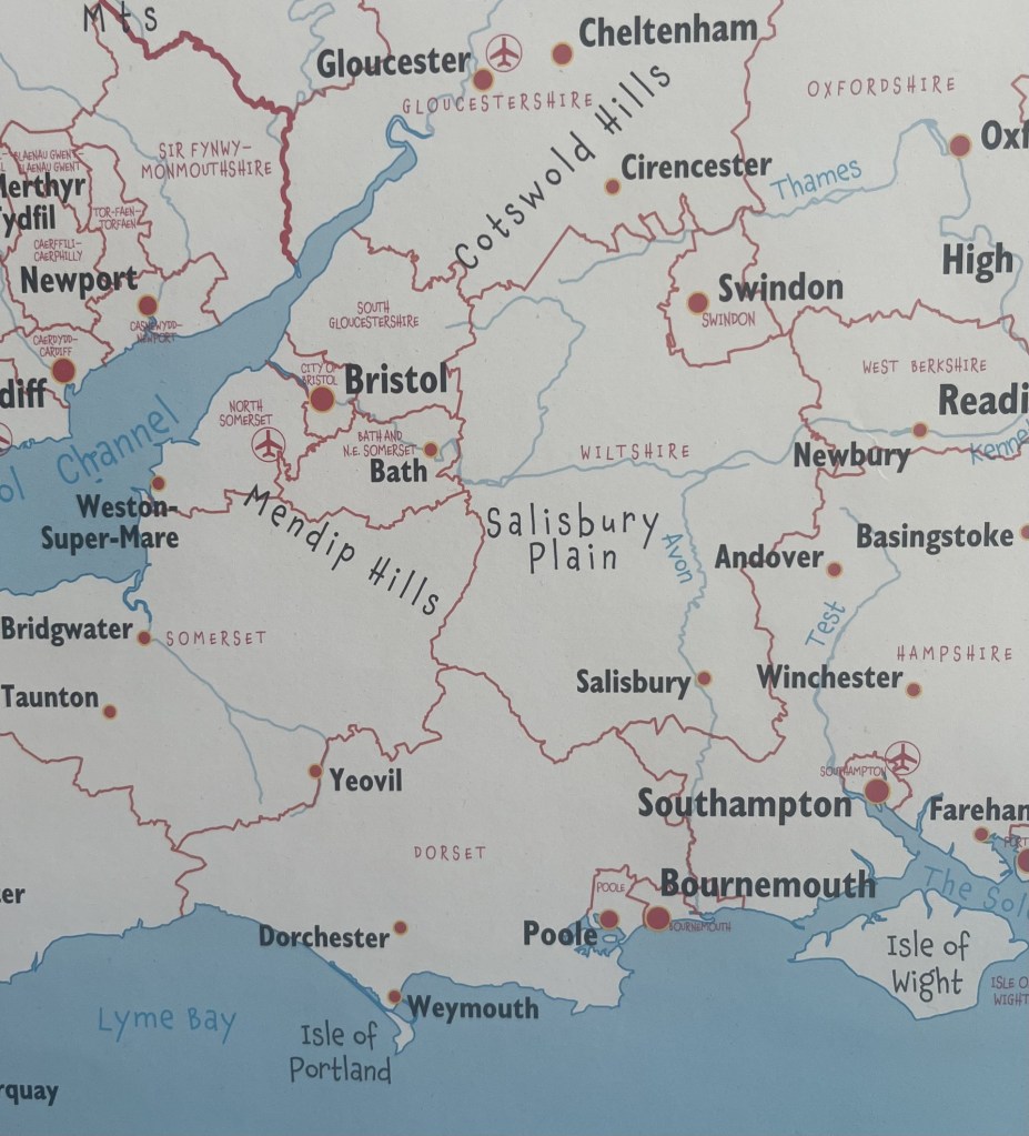
The good news was that I would be passing through the north of Hampshire, where Pilot Hill marked the county’s highest point. The City of Bristol was also on my list and would be an easy win. But, looking more closely at the region around Bristol, it became clear that any previous assumptions had been misplaced. Somerset had been on my radar, but the map, published in 2014 was showing far more “counties’” than I had expected, not least South Gloucestershire.
Back in September 2024 I had climbed Cleeve Hill in Gloucestershire and had assumed it had been a done deal, but no, not according to my map. It was a mystifying blow. What had I missed when I created my original list? Turns out that what I had missed was the huge change in the political landscape that has taken place in the last half century. Of course, I knew that some of the old historic counties had long gone, Middlesex and Caithness for example, but it had completely passed me by that much of the country, (especially England) had since been subdivided (presumably due to shifting demographics, or let’s be a tad more cynical, gerrymandering?).
What my planning strategy to visit the West Country had revealed was another entity, with, from what I could glean, similar powers to traditional counties – the Unitary Authority (UA).
On one level this was deeply troubling. At the time I didn’t have the gumption to count how many additional regions were about to enter the fray, but a brief look suggested at least some tens more. But on a more positive note, this now offered up many more opportunities, not least the many Unitary Authorities that now presented themselves for inspection over the coming days. South Gloucestershire for starters, but also Bournemouth, Poole, Christchurch, Southampton and Portsmouth, that I would be passing through on my drive home a few days later. And that didn’t include North Somerset, and Bath and Northeast Somerset, which, whilst being near Bristol would have been too much to attempt during my tour.
Over the last few weeks of the self-imposed calendar year (May to April), I started to update my list of counties by adding in the Unitary Authorities. This revealed other troubling difficulties. Again, working from information on the internet, inconsistencies began to emerge. For instance, my map had shown there to be three UA’s sitting next to each other in Dorset; Poole, Bournemouth and Christchurch. This had led me astray when I had passed through the area on my way to Portsmouth. The reason being that in 2019, long after the publication of my map, these three authorities had merged to become BCP Council (Bournemouth, Christchurch and Poole). Shucks!
What this confirmed, had I not already known it, was that whilst the map was helpful, it was already out of date, and couldn’t be relied on to provide a definitive list. Again, I faced the difficulty of trying to locate an accurate list of all the UA’s. In the end I decided to opt for the information on Wikipedia, which from what I could tell, was likely to be as accurate as anything.
Needless to say, my list has expanded exponentially and is likely to keep me occupied for some time to come.
The UA/County, West Country complication
Local authority elections were held in England in May 2025. I spent most of my life in London but now live in East Sussex. I am pretty sure that when I was growing up the county of Sussex was a “thing”. But I am wrong. Sussex has been divided between East and West Sussex for centuries, and maybe as long ago as the 12th century. 1889 was the year that saw them fall under separate council governance, and in 1974 this was formalised following the Local Government Act of 1972. Now what constitutes the entirety of old Sussex consists of East and West Sussex, and the Unitary Authority of Brighton (yet to be topped).
Along with all residents of voting age in all three authority areas I was unable to vote in May. Along with several other areas across the country the government paused elections whilst a period of consultation took place to decide on whether the whole of the county should come under a single authority. Because the outcome is due in the next year or so, it was decided that it would be too expensive and impractical to hold elections for councillors who may, or may not, be out of a job in just a few months. Not only could that see the end of East and West Sussex and Brighton, but potentially lower tier authorities such as Lewes, Worthing and Hastings.
Sussex covers a massive area. It stretches from Camber Sands in the far east, East Grinstead in the north and to Wittering Sands in the far west. It’s approximately 90 miles from east to west along the coast, and, just for the record, takes bloody hours whether by road, or even worse by rail. And, apart from the Channel, what these places have in common is probably restricted to the consumption of the rather fine Harvey’s Best. Of course there is an argument that in an age of austerity, and where confusion presumably reigns over the plethora of computer and information systems that must operate, combining the authority into one, would, in a nutshell, bring obvious efficiencies of scale. I can see some benefits in that, and am yet undecided, but my gut instinct is that if it is agreed, local democracy will be stifled. At a time when there appears to be a thirst for more localism, this feels to fly in the face of that process. A single authority and an elected Mayor running this huge, and hugely economically, politically and geographically diverse area? Hmm. I’m not so sure. I certainly need to give it more attention. At least (except for Brighton, which I guess I may need to do pretty sharpish) I have stood on the highest points of both East and West Sussex.
My last walk before the end of the calendar year took me on a train ride into Kent, and from Snodland Station up to the top of the Medway Unitary Authority (yup, this wasn’t a place I had anticipated visiting until recently). That day marked the first day of Reform UK gaining control of Kent County Council (not subject to any consultation on a single authority). Hmmm, well we’ll have to see how that goes. Their first act in office was to remove the Ukrainian flag at County Hall. Gesture politics, tokenism, who knows but feels like Vlad the Invader has just got his little tippy toes on the beach at Pegwell Bay.
Before I end this introspection, a word of warning to anyone thinking of putting on the boots and pursuing the county tops (and UA’s, and Metropolitan Districts – Oh, did I not mention them?). Speaking of Sussex and putting it back into the context of this arguably futile pastime, whilst looking at some of the many blogs and websites by other committed county toppers, one in particular caught my eye. I can’t now remember how I got to Richard Gower’s site, but not only was he going after all the current counties, he had gone so far down a wormhole (and I say this with affection), that he had completed all six of the ancient “Rapes of Sussex”. These ancient administrative areas divided the county, running west to east, into six areas: Chichester, Arundel, Bramber, Lewes, Pevensey and Hastings. It’s fascinating stuff, but it’s a cause too far for me. It may be that as the sands of time catch up with me and I find myself less able to travel, visiting their respective highest points (and as it happens, I have already unwittingly done at least two of them), could become an attractive option. I’m also imagining that if the rest of the country was at one time divided into these ancient domains, the quest would become an unending toil in every sense. All that aside, I must take my hat off to Richard Gower. It’s a pukka site. **
Just a final note on the website (if that’s what it is?). It’s rubbish. Moons ago I completed several bike rides along the coast from London, around Kent, and most of Sussex, and after each wrote up some notes on a Word document. All very well but once done, would I ever revisit them? My daughter had started posting some things on a website/blog. I liked the appearance, and as importantly I could read them on my phone without the word blindness that normally prevails. For no reason, other than I had heard of it, I started to transpose the words from Word to WordPress, added a few photos and some infantile art, and began to post each leg of the bike journey under the perhaps less than original title of Pier to Pier. *** Whether or not people read the posts (on one day I had 15 odd “likes” from what I had to assume were “bots” and emanating out of the US, given that it appeared nearly all were teenage females whose likely interest in a cycle ride round the Isle of Sheppey was deeply suspicious), didn’t concern me. What I gained from it was the thought process and then, whenever I chose, being able to read them on my phone, or any other device, to remind myself of what I had done.
I’ve been writing since I was ten (to paraphrase Marc Bolan). Immature diaries, essays, short thoughts on bands and gigs, futile attempts to write a book, and then over thirty five years, millions upon millions of words in memos, letters, works order tickets, emails, reports, presentations, minutes and many moments of long reflection when things might be getting too much, and when self-articulation through pen and paper, or keypad and screen, relieved the pressure; like lancing a boil. It may sound a bit contradictory, given that each escapade I publish an account online, but I write (primarily these days) for myself. The accounts reflect how I was feeling at any one moment, what I might have been thinking about, if there were local or international events that might influence the narrative and any significant landscape or features worthy of note. They are not intended to be a fully formed guide to other intrepid walkers, so beware should you choose to make one of these ascents solely based on one of these reads. Unless it’s obvious or easy, always take a map, and of course a phone (and keep in mind that a phone can run out of battery or connection, a map never does).
None of the above justifies the utterly useless presentation. I have honestly tried for hours to create a landing page where different threads and menus are clear to see (like everyone else’s), but I’m no further forward that I was years ago. The next time anyone younger than me visits, I’m going to have to collar them. In the meantime, what it is will have to endure.
The music – well that’s just an afterthought if something about the day has brought a tune to mind.
So, having walked to the top of Betsom’s Hill, and with some more county tops on the near horizon, so to speak, it made perfect sense to commit each experience to the page, and then the world.
I discovered one other key detail, and as such see the need to advance a precautionary slice of advice. Some weeks after climbing it I discovered that Sugarloaf Mountain was not the highest point in Monmouthshire, it’s the highest peak. When I found this out and given that it had been the motivation to start this project, it came as a bitter pill to swallow, not least because at some point I’m going to have to go back and climb to the actual highest “point” – Chwarel y Fan, which sits a few miles to the north of Sugarloaf. Well, at least now I know. Here’s coming for ya..?
Having spent the weekend with my daughter and her partner in Bristol, and having successfully claimed Hanging Hill in South Gloucestershire, rewarding myself with a strong coffee at the Swan Inn at Swineford, I drove south down almost vehicle free roads through Somerset, then east Devon and eventually into Lyme Regis in Dorset. A couple of nights booked in the Nags Head before heading back east to see friends in Portsmouth, then home.
After booking into my small room in the Nags Head and then having spent a couple of hours near the sea front trying the fish and chips and a couple of pints of the local ale, I set off up what felt like a 45% hill back to the Nags Head. By the time I arrived, panting and crawling over the threshold, with one of the patrons saying to me “have you been out there the whole time?” to which I had no answer, I flopped at the bar, rationalising that I desperately needed a small whiskey before bed. With fortification in hand, I took a seat whilst the last of the punters supped up and left. On gazing around my eyes fell upon a picture on the wall. It spoke of more optimistic times and for a moment I felt privileged to be in this space.
Toasting the man
Lewesdon Hill, Dorsets highest point, was a thirty-minute drive northeast of Lyme Regis. I decided on parking up in the village of Broadwindsor, located just north of the hill. As I neared the village, driving along the B3162, a stationary police car was parked up on the road ahead. I drew up behind but was waved on. Just up the hill, a second police car was pulled over next to what appeared to be an abandoned car, and a couple of officers stood silently by, with arms crossed.
I drove on and within a minute was parked up in a small close to the south of the village. The weather was perfect. Almost too perfect. I had no summer clothing so chose to leave my coat in the boot. The OS Explorer map (116) showed a route out of the village and straight to the top of Lewesdon Hill. It required walking into the village, which was fine because I needed a snack and guessed that the settlement was just big enough to support a shop. Fortunately, there was a profusion of old-fashioned signposts, and on each the words, Village Shop, as if it was the biggest attraction in the area. Maybe it was.
Surprisingly, being a Monday, the small community shop was open, although in truth it was rather lacking in immediately edible stock. Reluctantly, (I had walked in and so walking straight out would have been seen as a tad rude) I settled for a rather unappetising looking vegan sausage roll thing, made by a large food company that rhymes with “balls.” The shopkeeper was almost certainly delighted to see the back of it, but hey, needs must.
After procuring the snack and a cola, I walked back up to the White Lion Inn (closed Mondays) and headed west on err… West Street. A small house on the corner had a stone sign above the door that claimed Charles the Second had stayed there for a night in 1651. What it didn’t say is that he was fleeing from Parliamentarian troops after the battle of Worcester and escaped the village dressed as a woman. Just the previous day I had stood at the top of Hanging Hill in South Gloucestershire where, eight years before, a large force of his father’s military sustained appalling losses against a Parliamentarian army, taking the high ground before retreating.
Perhaps more interestingly, Broadwindsor also had a 17th Century vicar called Thomas Fuller who, apparently, often had his congregation in stitches. Who wouldn’t have wanted to live in a place which, whilst plague, and the warring elite ravaged the land, had a Sunday morning comedy club? I have an image of Paul Merton standing at the pulpit and drifting off into a flight of fancy, although having read a couple of Fuller’s “jokes” I think it’s likely that these days we would struggle to understand the nuance. By the time Charles the Second sought refuge in the village, Fuller was no longer the vicar, so missed the opportunity to crack a line at the King’s expense.
West Street wound down a hill to a bend in the road (which headed on up beyond). A footpath sign pointed south and confirmed the evidence on my map. Passing between a handful of buildings the path crossed a sparkling stream before reaching a large gate, with fields beyond. So far, so good. The gate, of course, was locked. There was no sign to indicate why. I don’t get annoyed in these situations, but it happens too often these days and can be mildly disconcerting. I looked around to see if I was missing something and noticed a small track leading away to my right, following the stream and through some woodland. It felt a bit unlikely, but I was in no rush so decided to follow the path and see where it took me.
Which was about 200 metres. The path petered out as it became overwhelmed by marshy ground. A delightful spot, but for me it was back to the drawing board, which meant a retreat to the gate. I looked beyond the gate and eyed up the path that clearly led to the top. No sign of a bull. I looked at the map, which showed an alternative path, but which required beating back through the village. I looked around. No one was in sight, so without further thought I was up and over and then stepping boldly along the path.
From there on it was reasonably straight forward, although at another locked gate a sign pointed east towards an alternative route, which I duly observed. After twenty minutes or so I arrived at a gate that marked the entrance to the Lewesdon Hill site, managed by the National Trust. Ahead lay dense woodland, with a variety of mature trees climbing up the steep slopes towards the top.
The approach to the enclosure
Proceeding through the gate, a large, mounted sign provided information about the area, the flora, the fauna and that an Iron Age settlement had probably existed on the site. That this seemed to be any doubt felt odd. It seemed to be a perfect setting. The board also stated that Lewesdon Hill was “the highest, quietest and most remote place in the county”. From what I had witnessed so far it felt a little bit like stating the bleedin’ obvious, but I wasn’t complaining.
A few steps on and a second sign. Slate grey, with the image of a Spitfire flying overhead in the top right-hand corner. I anticipated a sombre story.
In summary, on 15th March 1942, Jean Verdun Marie Aime De Cloedt, a Belgian in the RAF, in poor weather and with a faulty engine, crashed into the top of Lewesdon Hill. The commemorative board also mentioned that it was still possible to see the destructive path the plane had taken through the trees at the top. It felt like an unnecessary detail, but regardless it was a poignant tale. An intimate human story at “the highest, quietest and most remote place in the county”. Wars and hilltops. It was becoming a theme.
Chert stones that must have travelled down from above and onto the sandstone bedrock, scattered the path that headed south towards the top. Unusual, but would almost certainly have made this an attractive spot for early flint pioneers.
Within five minutes the path broke from the cover of the trees onto a heathy plateau and continued towards the only point that looked slightly higher than the surrounding topography. There was nothing of note to pinpoint the spot, but a hump of grassy earth seemed to be the place. I looked out to the south and towards the sea some miles away. Rays of sunlight swarmed through the large gaps between the trees. Looking down the steep escarpment the sun on the otherwise stark branches revealed the first, almost indiscernible, green blush of new growth.
From the top – Looking south southwest towards Morecombelake
Despite the delay in making progress at the foot of the climb, (due to the locked gate) I had made good time, and so after taking a few bites from the almost inedible vegan roll (cardboard wasn’t included in the list of ingredients, but I think it should have) I followed another path heading west and above the drop to the south. And a considerably steep and long drop it was too. Despite almost qualifying as a cliff, ancient birch and oak trees rose up from below, climbing and clinging on bravely to the thin earth. At some point it occurred to me that this was likely to have been the area where Jean Verdun Marie Aime De Cloedt’s plane had torn through the trees. I chose not to try and work out where.
Reaching the end of the plateau area another notice board gave more information, which must have made no impact on me at all, given that I can’t remember a word. A view opened out. The land fell away, but then rose again to the top of Pilsdon Pen, about two miles to the west, which even from a distance revealed features consistent with a hill fort.
West towards Pilsdon Pen
Scrambling down the north slope, on land recently cleared of larger trees, I was back on the main track which forms part of the Wessex Ridgeway and banked up to the right. The sound of a helicopter overhead intruded but tailed off as it headed north. Soon I was back at the entrance with the information boards, and after a quick look back set off across the first large field. I had noticed on the map that at the end of the field another path veered to the northeast and past Fir Farm. This was a more direct route back to the car and avoided having to negotiate the closed gate.
Objective Broadwindsor
By a large farm building I found what appeared to be the route, heading into some woodland. The noise of the helicopter should have long gone by now, but it was still audible, somewhere just to the north. Entering the woods, it was evident that the trail was little used. A sign had been attached to a tree, informing people like me that due to storms the previous year some of the trees were unsafe and walkers proceeded at their own risk. The sign itself was a year old, and I figured that the landowners would, by now, have taken the necessary action to make the area safe.
This was a lovely spot, a proper dingle dell. A low wall appeared ahead, with a nook cut out to allow the traveller to cross with ease. As I stepped over, something about its appearance had me confused. What kind of stone was this? I looked more closely. What I had thought was a stone wall was in fact a massive fallen tree, so embalmed in moss and lichen that it mimicked a human structure.
Not exactly sycamore gap, but art in nature nevertheless.
Carrying on down through the winding path the noise from the helicopter began to increase, annoyingly. Perhaps it was the military on manoeuvres, or a crop being sprayed with agent orange. Either way it was taking the edge off the afternoon. A bit further on and the path began to flank a track leading back to the farm. Looking ahead something stopped me in my own tracks. Through the trees and hedges, and about 200 metres further on, I could clearly make out the intermittent red and blue lights of a police vehicle.
In the 1935 film, The 39 Steps, Richard Hannah (Robert Donat), is on the run on a Scottish hillside when out of the blue (and out of all context given that Buchan’s novel was set before the Great War) a helicopter appears, hunting him down. Now, I should say at this point, nothing remotely interesting has happened to me for a very long time, although two evenings earlier in Bristol I had witnessed what might well have been a stolen motorbike being crashed at 5mph, and completely bizarrely, into a wall, before a car pulled up and swished the fallen rider away. Surreal. Nevertheless, and just for a moment, with the sound of the helicopter above, and knowing the cops were hovering somewhere just down the lane, my thoughts were suddenly hinting at the prospect of a manhunt! But who, and why? Was it fight or flight time?
Momentarily I engaged in mental research. Who was I? Robert Donat, Kenneth Moore, or, controversially, Robert Powell. I settled on Robert Powell, largely on the grounds that I had liked him a lot alongside Jasper Carrot in the TV show The Detectives. Now all I had to do was to get past the police checkpoint. Did I have my papers? It’s essential to have papers on you in these situations. I patted the inside pocket of my jacket. Hmm… would the Nectar loyalty card suffice? I was about to find out and started to walk purposefully towards the blues and twos.
I noticed that the police car lay beyond another vehicle and realised that I had reached the point I had passed in the car on my way into Broadwindsor. Whatever was going on seemed most particular. I reached the end of the drive and volunteered a “hello” to the two officers idly guarding the mysterious car. I think they may have said something back, but either way I wasn’t subjected to any stop and search, or interrogation, for which I was most grateful, although as I carried on along the road back into town, with the helicopter still bothering around above, I wondered whether the officers might have been a tad neglectful in their duties.
Back at the car I checked the app which had been recording the walk. 2.79 miles. 411 ft elevation gain. 670 calories. 8k steps. No more, no less. Oh, for 39 more! But never mind, for an hour or two, in a remote part of Dorset, which had once been the home of “Have I Got Sunday Morning News for You”, I had been away from the numbers.
A beautiful Spring morning in Bristol, and a few hours to spare with my daughter and her partner J, before heading south after a short but very enjoyable weekend visit. They were both aware of my growing interest in seeking out county high points and indeed had previously enabled me to the tops of Ben Nevis and Snowdon. Was there somewhere locally where a short walk could take us to another county top? Well, up until a few weeks earlier I would have said no, and time was too short to hop over to south Wales. But that was before I had discovered a new county (or so I thought).
In October 2024, when I had climbed Cleeve Hill, I thought I had ticked off Gloucestershire. As winter came and held me in the grip of my local area, I found a map of British Counties online and ordered it. When it arrived it was exactly what I had in mind. Very simple, with the key information, and massive. I bought a large piece of plywood and carefully mounted the map using double sided tape. Now, all I had to do was work out a methodology of categorising the high points (by height obviously, but also by geology, for no other reason than to complicate the process), and then begin to annotate it as and when a new cresting occurred. I should say at this stage that it’s become quite a complex beast, and I’m a while away from any annotation, but something happened a few weeks ago that radically altered the dynamic.
One of the joys of having a huge, mounted map is that it’s easy to look at and take in geographical relationships and direction. When it comes to looking at maps on my phone, or on a PC, my spatial/visual awareness seems to go out of the window. I guess I was just born too late but give me a map in the hand and by and large I feel like I am in control. Of course, I couldn’t fit this map into my hand, but when I was planning the weekend in Bristol I had sat down and looked at the big one to see what counties might provide opportunity, either on the way there, or on the way back. It all seemed straight forward, until err… until, just past Wiltshire (yet to do), appeared a county called South Gloucestershire. What the what the?
South Gloucestershire wasn’t on my original list of counties, but sure enough it exists, as a Unitary Authority since 1996, and after the abolition of the previous authority of Avon. Whether or not including it in the itinerary is open to debate, but it was on my map and delivers all the services provided by Gloucestershire council to the north. It couldn’t be ignored and given that its high point was just a few miles to the east of Bristol, I offered up Hanging Hill as a short walk option before parting company.
We drove out of Bristol on the A431 (Bath Road), and just before the Swan Inn at Swineford turned left and along a track through a farm, pulling up at a small, very serviceable and free, car park set in a thicket of trees. You don’t get many of these for the pound these days, but without the need to have a ten minute confrontation with a pay by phone pay and display machine, I wasn’t complaining. J had done the research, and we set off east, past an old mill stream, and then into a large field with what appeared to be free range ostriches in the one adjacent.
Passing through a line of trees we entered another field, with the path then rising steeply until reaching another tree grouping flanking an ancient drover’s lane. The track, with steep banks on either side, continued up, but without being obvious, started taking us southeast, and away from our objective.
Steeply hollow
After plodding on up for nearly half a mile a path leading away from the track appeared to our left. Following a straight path we entered the seemingly exclusive hamlet of North Stoke. A road continued taking us east. A small red-letter box set into an impressive stone wall forming part of one of the more impressive buildings gave rustic charm. Continuing on and then left again past the modest but aesthetically pleasing St Martin’s church, we started to ascend another steep track that formed part of the Cotswold Way.
I should just say that, having stripped off various layers, and now down to my T-shirt, I hadn’t expected to still be climbing UP at this stage! I hadn’t really been paying much attention to the route and had assumed that we had parked quite close to Hanging Hill. I made my first inquiry whilst panting at each weary step. “Are we nearly there yet J….?”
Reassuring noises came back. Suitably reassured, I found a new lease and before too long (at least another half mile!) we reached a bench next to a gate leading onto a golf course. We were now on the Cotswold Way and that meant more walkers. A shame for me as out of nowhere an enthusiastic group appeared and colonised the very bench that, as we had approached, I had coveted over the previous two minutes.
We stopped, standing, to get our breath back (well, that’s what I was doing at any rate) and took in the impressive panorama looking west and towards Bristol, the Severn, and the Welsh mountains beyond. From the lie of the land, I assumed that we weren’t too far. “Are we nearly there yet J….?”
J consulted his phone. “Yup,” he replied. “That’s it just over there.”
Of course it was…
I looked north. The land fell away steeply into a valley and then rose again towards a clump of trees at the end of a ridge. Just over there, yup, about a mile just over there (as the crow flies). Now, I had all day, but it was a Sunday, and I hadn’t wanted to eat into too much of my hosts remaining hours before their new working week. If, at that moment someone had said that getting to Hanging Hill was going to take too long, I would have surrendered the task there and then, to return another day. But nothing was said and so we continued on, flanking a pleasant looking golf course to the right and woods to the left. At least now we were on the flat.
Just past an old farm building, in a fallow field, a collection of metal fantasy sculptures had been let out to rust slowly in the elements. I’m not necessarily a fan of “industrial” art, which I find somewhat contrived (I can’t find an emoji of Morrissey, but if one exists, insert here), but on this occasion I was suitably impressed. Something about the location perhaps, but also the aesthetic and the way the Grim Reaper with dog, and other Tolkienesque characters had been positioned pulled me in. I considered taking a closer look, but time was pressing, and the need was to move on.
Sculptures by David Michael Morse – Deceased
The track continued up to a crest, with the golf greens now on our left. We headed northwest, still on the Cotswold Way. A delightful wood, covered in a carpet of thousands of wood anemones stretched out to our right. A suggestion to wander through these woods was vetoed. We appeared to be at the limit of our time window. The greens we passed seemed to stretch forever, and judging by the disastrous tee-shot swing (and hope) by a possibly hungover weekend golfer at the nearby tee, his game was going to be a stretch too, far.
Here the course ended and just ahead a gate beckoned us into a large field that vanished to the horizon, which was dispiritingly far away. By now there was a palpable tension. I’ll leave out the details, but entertaining the old man’s cranky new hobby had clearly run its course, and I had run out of credits. We had come too far to turn back. My own assessment of the land and the area suggested that we could make a dash back to the cars an alternative way, but for the moment it was important that I focused solely on apologising with conviction for my selfishness and trust for the best!
We crossed over the large field, a path clearly pointing us towards our destination. Minutes later, and to my overwhelming relief, we reached the trig point that marked the top of Hanging Hill. I was tempted to say we didn’t hang around, but sensibly we stopped and took a five-minute break. Hanging Hill? No idea. The next one to the north was called Freezing Hill. You get the medieval idea here.
Just hanging around. Trig points are handy things to rest on.
Just past the trig point, an information panel told us a bit about the Civil War battle of Lansdown, fought on this spot in 1643. With time pressing I chose to take a photo and read it later.
Limited information
This is not a history lesson, and in truth, as I found out later, neither was the information panel. * If we had had more time, it might have been possible to survey the scene and appreciate more the scale of the carnage that had occurred here four hundred years earlier. But the research would have to wait.
The killing field
The prerogative now was to get back to the cars as sharp and as shipshape as possible. We’d been out too long. The good news was that it looked like it was going to be all downhill from now on. Except we chose to set off northwest, heading away from where the escape vehicles were parked up. We trod carefully down a steep track through dense woodland, with the first signs of new growth all around. With continuing murmurings of discontent amongst some of the team, I quietly hoped the correct decision had been made. The track continued for, in my mind, too long, but eventually we spilled out onto a narrow road, and despite some hesitation decided to bear left and head west.
Marshfield Lane proved to be the win bonus of the day. Hardly a vehicle passed us, and progress was swift. A bank to one side of the road stretched for some distance, covered by hundreds of yellow primroses. Soon after we were passing the rather appealing looking Upton Arms in Upton Cheyney. No time though to contemplate the achievement over a coffee or cold drink. Onwards and downwards on Brewery Hill and then, at a sharp bend in the road, we followed the footpath directly down through a farm, then through a gate, and within minutes we were sitting in the garden of the Swan Inn at Swineford, the sun beating down and all was right with the world.
Mothers Day at The Swan Inn Swineford
It had been a longer hike than anticipated, with an unexpected, almost continuous 700 feet of elevation from the start to Hanging Hill, and much tougher than expected. Just under five miles, but thoroughly worth it, and in the end we were all still friends.
* The battle of Lansdown hill makes for an interesting read. Not that you would necessarily have known it from the information board, which gave the impression that the Royalist forces inflicted a crushing defeat on the Parliamentarians (under the leadership of Sir William Waller). The forces appear to have been pretty evenly matched, with Waller’s troops dug in at the top of the ridge, his left flank at the trig point. A fuller account is provided in the link below, but in a nutshell, it was a long and hard-fought battle over many hours and into the night. With ammunition low, Waller chose to retreat to Bath in the dark of night. With ammunition low but having sustained severe casualties (not least to many of the commanding officers), the Royalist forces gave up the chase and set off to Oxford in disarray. It had been but a pyrrhic victory for the Royalists. The two sides met again for a rematch a week or so later at Devizes, where the Parliamentary forces were soundly beaten after Royalist reinforcements arrived in the nick of time. The losses at Lansdown Hill are speculation but the estimate is that on the Parliamentarian side, 20 troops died, and 60 were wounded. Multiply both those figures by ten to get an idea of the scale of the losses on the Royalist side, not to mention the high casualty rate amongst its senior officers (Wikipedia). It must have been a brutal and bloody affair, with deadly skirmishes taking place between infantry and cavalry in the woods that we had walked down through. Sobering indeed.
After I read the fuller account of the battle, I was able to picture vividly what the calvary and infantry clashes in the woods above Marshfield Lane must have been like. Loud, close and very bloody. This very rarely happens to me at any historic battlefields, where it is impossible to imagine mass slaughter in a vast corn field. I also realised that, other than a superficial understanding of the English Civil War, I really knew nothing about it at all. Given not just the struggle, but also the fundamental principles involved and how it changed the world, within the week I had bought The British Civil War – Trevor Royle. With 900 pages I may come to regret the purchase, but without seeking out the highest point of this unitary authority, my ignorance would remain complete.