I had been driving around the large and presumably ancient village green at Langley Upper Green for several minutes hopelessly trying to find a legitimate parking space. Not because every parking space was occupied; quite the opposite – there simply wasn’t anywhere to park. Despite my frustration I had to admire the fact that you could take in the sight of the green space without the slightest hint of painted metal and rubber. After several reconnoitres, I noticed a modern building with its own small car park located on the greens eastern flank. I parked up, searched high and low for any signs that might indicate a vehicle indiscretion and concluded it was safe.
I was at Langley Upper Green because, from what I could tell, it was the closest starting point to get to the highest point in Essex, and a spot called Chrishall Common. Half an hour or so before I had been to the top of Cambridgeshire, at the nearby village of Great Chishill. At 146 metres high, Great Chishall is 146 on the list of County and Unitary Authority tops. At 147 metres Chrishall Common is 145 on that same list (keeping up?). If that’s some strange symmetry, make of it what you wish. Or maybe call it a plateau.
After weeks of drought and high temperatures, a gathering cold front was pulling low, grey but thinnish cloud in from the west and offering the possibility of rain. I pulled on a light anorak and set off across the green and towards the north-west corner, where I hoped to find a path into fields.
A gravel-based road ran along the north of the green, serving some houses on the northern edge, and then a handful of newer mock period houses ranged on the eastern edge. Not unattractive, and blessedly not gated off, but surprising given that I assumed the green had at one time been common land. Maybe it wasn’t. A look at a map from around 100 years earlier showed that the green then was about twice as large.
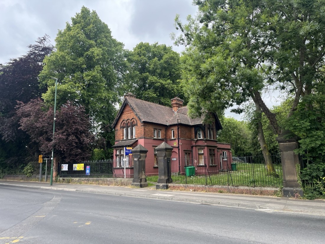
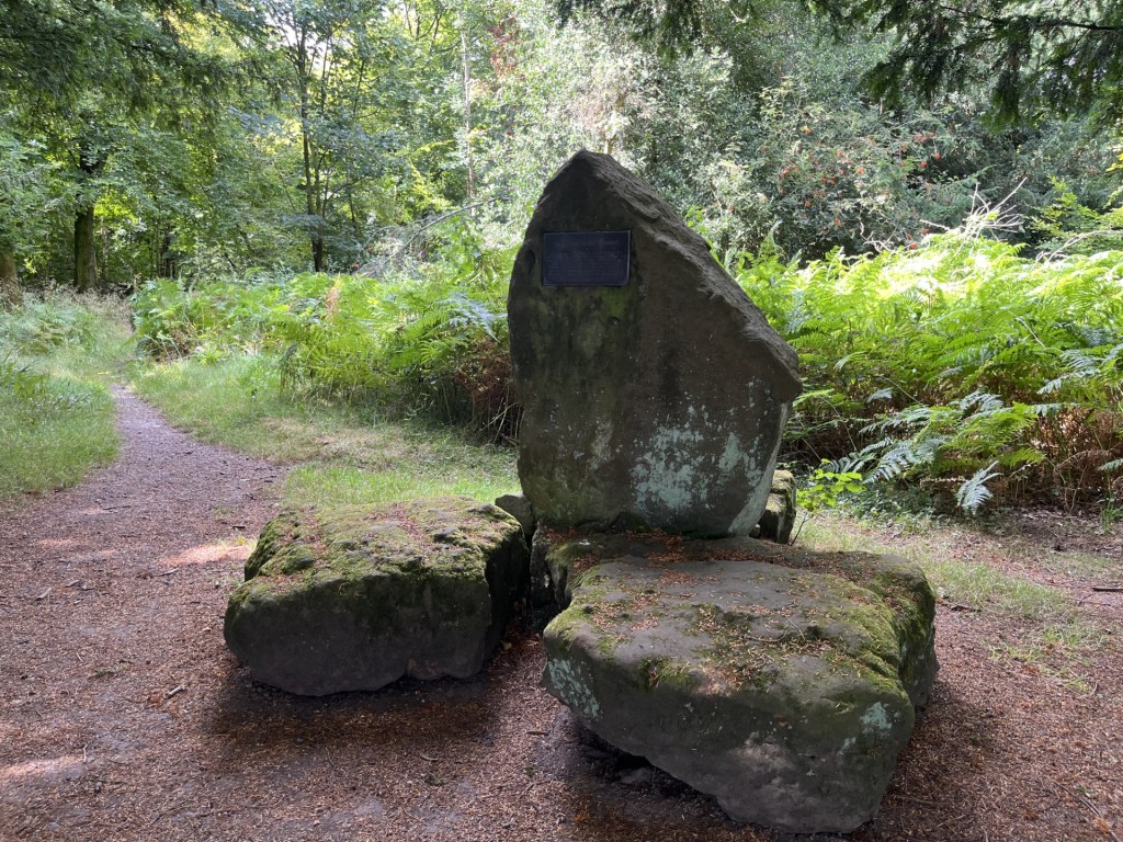
The green at Upper Langley – not yet gated
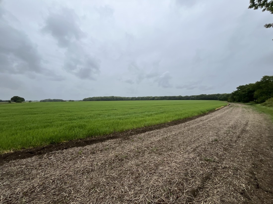
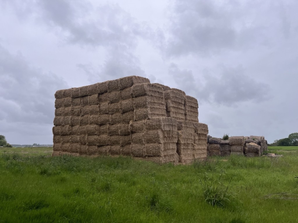
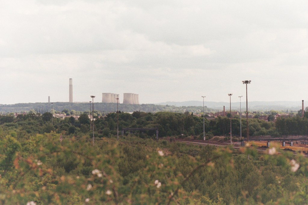
I found the path at the top of the green and then passed between two areas of land, possibly orchards that had been fenced off. This path led to a large field with a huge stack of hay, the size of a large building, that can be identified from space on Google earth.
Giant haystacks – The great Bale of Langley
A path flanked the field heading west and then a turn to the right and north and skirting another much larger field.
Sweeping up to the top
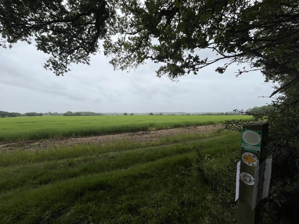
A stiff breeze brought with it spots of rain that threatened a possible deluge. It would have been very welcome, but never quite materialised. A large wood lay at the north of the field and stretched away several hundred metres to the west. As far as I understood it, the highest point in Essex was either in, or just beyond the line of trees. A path, identified by a post with multiple signs, led through the woods and into another field.
Every which way in Essex
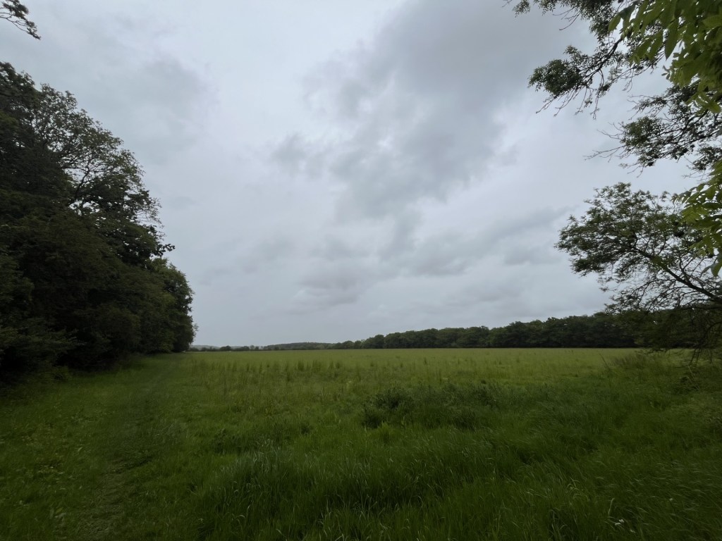
If the highest point was somewhere in front of me, it was impossible to pinpoint it, and as far as I knew it could have been back in the woods. With the threat of increasing rainfall (which failed to materialise) I retreated to the southern field, and within fifteen minutes was back on the green.
Chrishall Common – The high point!
As a leg stretcher I quite enjoyed this short walk in a big flat landscape. Maybe the overcast conditions didn’t do it justice, and maybe it would be best enjoyed dressed to the max and traipsing across the fields in a February blizzard with the wind whipping in from the east.
A distressing discovery has emerged whilst writing up this account. Earlier in the year, and based on sound research, I had climbed to the highest point in Bristol at Cossham Memorial Hospital, Lodge Hill. So, as I was checking down the height information for this piece on the Peak Bagger list I noticed Bristol, but it was showing a different name!!! What the what the???? Dundry Hill East! Dumbfounded, I did some searches and sure enough a recent article in Bristol Live explained that following a boundary change in 1949 Dundry Hill was quite a lot higher than Lodge Hill. Peak Bagger must have agreed and made the change. Finding this out means a lot of unpicking, but most distressingly requires another trip. Oh well, the joys.
After the night before (when Spurs had beaten Manchester United in the UEFA Europa League Trophy final, and after I had chalked off Rutland and the City of Leicester), I had one more day in Nottingham and felt the need to visit its highest point. I say I felt the need, but that’s not strictly true. To be honest I was just slightly hungover. Nothing that I was regretting, but just that slightly off feeling that thankfully I hadn’t felt in some years. Either way my brother was working from home, and it was important that I got out of his hair (of which he is still blessed, and I am not).
I’ve been to Nottingham many times; on a couple of occasions in the 1970’s on day trips from Leicester to the Old Trip to Jerusalem and other hostelries, but many more times after my brother moved there in the late 1980’s. I have to say it never occurred to me that it had any land higher than the site of the castle (which remains one of the world’s biggest disappointments, especially if you’ve ever seen any Robin Hood films). For everything else you’ll ever need to know about Nottingham, and the engineering beauty (!) of Maid Marion Way, I can’t recommend enough Mark Steel’s – In Town – Nottingham on BBC. *
I had discovered that the highest point in town was a place called Mapperley located vaguely somewhere in the north-east. Dosed up on coffee I drove directly towards the city centre, which involved passing the Trent Bridge cricket ground. There were a lot of people mingling around but I didn’t put two and two together (probably a county match I mused), and carried on over the bridge, with the Forest ground to my right. I should say a couple of things about Nottingham Forest’s City ground (just to string this relatively brief account out a tad more).
I’ve been there a few times with my brother and sister-in-law over the years, but mainly during Forest’s leaner years. The first time I went was with a die-hard Brighton fan called Trevor. From memory it was the second leg of the League cup quarter final, on a freezing winter night in December 1978, and for the life of me I can’t remember what convinced me to go or (being that I was from Croydon), why he had invited me in the first place. This was about the time when Forest were about to make history and had the classic Brian Clough line-up. We took a bus up from Leicester and by kick-off we were in with thousands of Brighton away fans.
It was an exciting game. The Brighton fans were boisterous throughout, but in the end Forest were triumphant, and eventually we set off back to the station (the surroundings of which have changed out of all recognition in the intervening years: the delightful Victorian Bentinck Hotel pub, now a desultory Starbucks) with the thousands of others who had made the long journey from the south coast. And that of course is where they left us, and we had to make our way to the bus station, on our own, in the rain, and with Trevor refusing to zip up his coat and cover his blue and white Brighton and Hove Albion scarf, despite my whimpered pleas to his conscience. With the streets still crammed with celebrating Forest fans, I had never felt more exposed. Dirty, threatening looks, abuse and the possibility of violent intervention at any time convinced me that if we survived the night and escaped Nottingham unharmed, I would definitely not travel with Trev to a Brighton away game again. We eventually made it out of town on the late bus to Leicester, and I kept my promise.
The other significant moment, just outside the City ground, was some years later when walking along the river Trent footpath with my brother and their dog. We were the only people about until ahead of us a group of male athletes on a powerful jog headed towards us. As they closed in my brother speculated that it was the current Forest team, and sure enough, as they passed, I recognised one or two. “Morning lads,” came the heavily Glasgow accented greeting from the older man at the rear. On the 11th of June 1978, Archie Gemmill had scored the greatest Scottish goal of all time against Holland in the World Cup in Argentina. As a Scottish family living in the diaspora we had watched the game, more in hope than expectation. When Archie scored his wonder goal the roof nearly came off the house, and in many Scottish towns and cities there are still buildings with structural damage from the resultant seismic aftershocks. Scotland won the game, but it wasn’t enough to qualify for the knockout phase, but it didn’t matter. Archie was God, and he had just spoken to us.
I drove further into the town centre and, without incident, managed to find myself heading north-east on St Anne’s Wells Road. I turned left at Ransom Road, simply on the basis that it headed upwards, often a useful clue in these situations. To my surprise the road rose steeply with interesting parks to the left and right. At the top I turned right onto Woodborough Road and eventually pulled up in the carpark of an Aldi to get my bearings. I was in Mapperley, and a quick check informed me that the highest point was just a short walk further to the north-east. The sign said I had two free hours, so long as I shopped in the store. It was going to be a risk, but I figured that the chance of parking up, not making a purchase and being caught, was low.
It was just a three-minute walk. The highest point seems to be at the rear of a bleak looking Victorian block of flats set behind some grim railings and gloomy woodland just opposite the busy and confusing junction with Porchester Road.
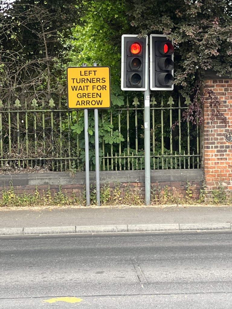
There was no helpful instruction for Right turners.
I passed on by. The oppressive heavy-duty railings continued to line the left-hand side of the road, behind which was what appeared to be a grass covered reservoir.
The grassy uplands of Mapperley
The highest point appears to be the back garden of this indeterminate bleak house
Walking back to the car I looked around at the most eclectic collection of buildings you could find in any place in the country. Mainly Victorian and early 20th century not one of them looked like the next, and without exception, other than a strange quirkiness, none had any architectural interest or value. It seems that high ground to the east of an industrial city does not a garden suburb make.
I’d chalked Mapperley off the list but still had a few hours to continue my Nottingham investigations. I had an objective. Something I had been aware of for some years but had not had the opportunity. I drove back into the centre, navigating tricky road layouts, past the castle and then west, eventually reaching the area of Toton an hour or so later. I parked up on a new estate and then headed into the Toton Fields Nature Reserve. After twenty minutes or so the rising land took me to a point I had hoped existed. I knew I was there because there were a few other people with cameras and binoculars looking down the slope to the west, and the noise below was distinctive.
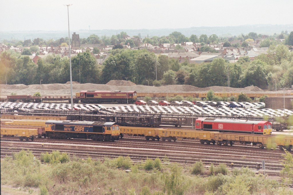
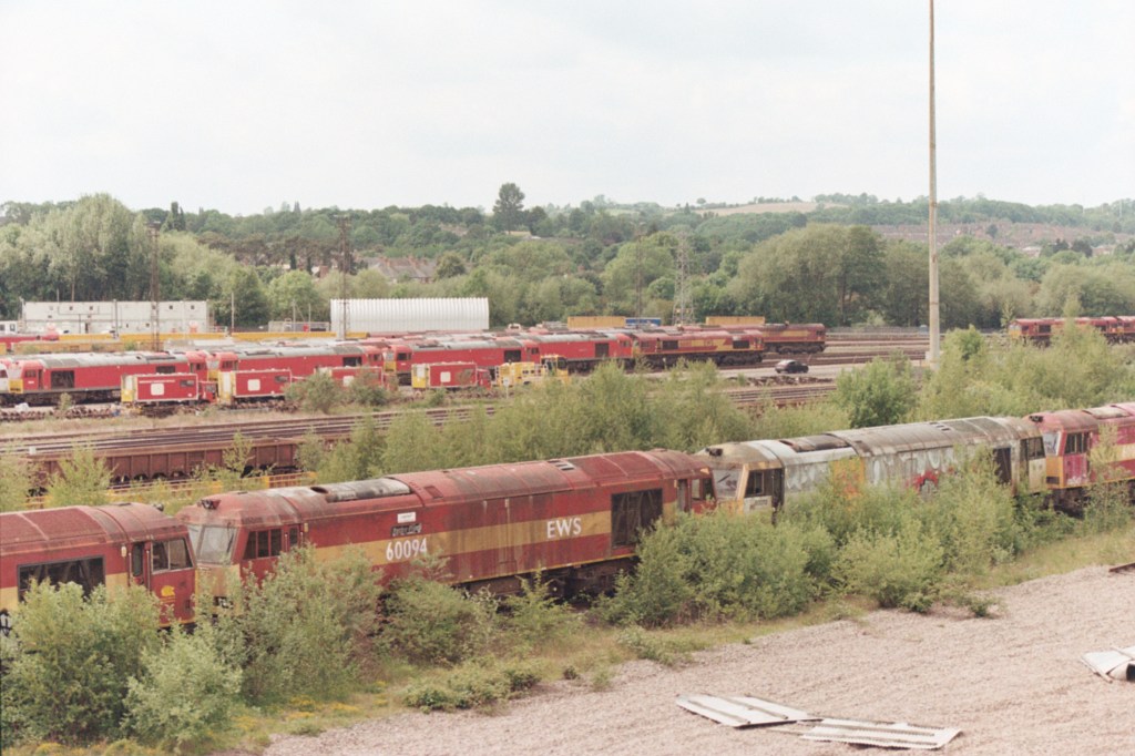
I was overlooking the Toton marshalling and freight yards. A hive of railway activity with locomotives slowly moving north and south, vying for position. Every so often a long freight train pulling through. Immediately below two peripheral sidings were the final resting places for scores of redundant diesels, just waiting to be scrapped. In a way quite a moving sight but somewhat inevitable given our rejection of railways as a means of tackling our multitude of problems. But beyond, the activity suggested that whilst the rail freight business might be down, it wasn’t quite out. And the only reason I am talking about this at all is that the site contained the largest selection of Class 66 diesel locomotives in one place that I have ever seen (and they weren’t all red) **
A colouration of Class 66s.
The end of the line at Toton
I could have sat and watched the activity at the Toton yards for hours more, but it was time to go back to West Bridgeford.
I walked back south on the low ridge (which I guessed was artificial) and just as the yard was coming to an end, with my route out of the reserve to the left, I looked up. On the horizon, perhaps a mile or two to the south, the huge cooling towers of the old Ratcliffe on Soar power station reared above the low Nottinghamshire plain. It occurred to me that it might be the last time I would ever see it, it having been in my line of sight on hundreds of occasions since the mid 1960’s. Coal powered and out of date, it nevertheless always had an uplifting, cathedral like and overwhelming appeal. But, despite the unaccountable nostalgia, it must go and for the last time I took a photo.
Fair ye well Ratcliffe on Soar.
After navigating through the usual late afternoon urban congestion, I found myself driving back past the cricket ground. It was heaving, which was a surprise. The radio had been on and suddenly they had gone over to Trent Bridge for an update on the cricket! England v Zimbabwe one off test match. And at that moment I was there, but not. How could I have missed this opportunity? I reflected that I could have spent the day in the sun watching the great game, but then, just think what I would have missed if I had.
The day after reaching the top of Bournemouth, Christchurch and Poole (UA), and a debatable claim to the highest point of Southampton, I awoke in Southsea, and to another sparkling but breezy day. I had some hours to kill before shifting back home, and so, with the couple I had been staying with, took a long and invigorating stroll along the seafront to Southsea Castle. With small, middling and large boats, vessels and ships slipping in and out of the channel, and across to the Isle of Wight – like a south coast version of the Bosphorus – there was so much going on it never crossed my mind to take a photo.
Over a coffee in the attractive Southsea Castle cafe, I tediously blabbed on about recent adventures and reaching the highest points of counties, but that it had now come with the additional complication of the Unitary Authorities. I think it was just about then that they started getting twitchy about when I was actually going to leave. “So,” I asked, “how do I get to Portsdown Hill?” At which point I noticed the life force leaving them both. Almost without thinking they told me it was above the main hospital and gave me what they claimed to be easy and accurate directions.
After bidding them farewell I headed out of Southsea, the same way I had come the evening before, this time without any major traffic jams. I reached the M27 which I crossed, and despite confidence in my directional skills almost immediately ended up on an industrial estate that had me befuddled for over twenty minutes. I eventually discovered the tiny road out and up, more by luck than design. I was relieved to have escaped the labyrinth of small roads, not least because I suspected that the more observant bystanders in the area were concluding that I might have been casing one or two of the units in the pursuit of criminal endeavour.
I knew my way now. Continuing uphill I came to a roundabout and turned left. Almost immediately I suspected an error, and at the first opportunity turned right into a housing estate. Actually, I thought, if I continued up, I might get to the hospital (one of the primary reference points suggested by my friends). Despite the grid pattern estate roads, one way and no entry system had me in another pickle. I surrendered, pulled up and consulted the phone. No, there was no way to get to the hospital without going back down and out. The road I wanted was just above me. I could see it. Vehicles were heading up and down the road cut into the chalk.
Eventually the estate spat me out and I was, at last, on track, passing the hospital and heading up the steep chalk incline on Southwick Hill Road (which judging by its appearance must have once been a long cliff butting up to the sea), and to the top. I crossed over a roundabout heading west and then followed the road (the brilliantly named James Callaghan Drive), for a mile or so before it started to lose elevation. The day before I had stayed in the Nags Head in Lyme Regis, which in 1964 had entertained Harold Wilson. For younger readers, and any wider audience, most will have heard of Harold Wilson, but not so many perhaps of his successor as Labour leader, and then Prime Minister, James Callaghan (Uncle Jim). Two socialist PMs in two days. Maybe this could be a new hobby – seeking out places honouring socialist Prime Ministers (it probably wouldn’t take too long). Callaghan had been born in Pompy. He lost the 1979 election to the Tories. I had voted Labour but to no avail (I was just 21 and it was my first time). I graduated the same year, and (I won’t mince my words) along with millions of others, spent the next three years either out of work or in temporary employment, primarily due to the slash and burn policies that were subsequently implemented. Nice to have a road named after him, I thought, but I had to press on. I was at Fort Southwick, but that wasn’t where I wanted to be. My friends had been quite specific. The highest point was surely Fort Widley, just above Queen Alexandra Hospital. Who was I to argue with the locals? I turned the car round and then set off back the way I had come, and at the roundabout continued over and, soon enough, came to a turning into a small road that I knew was going to get me to Fort Widley.
It was a busy spot. I left the car and walked past the burger van and into some overgrowth where a path hinted at further progress towards the top. The huge 19th century fort came into view, but despite a scout around to left and right, further progress seemed impossible as the entire massive fortification was protected by a modern metal fence with pointy bits on top.
I strolled back to the car, satisfied that as far as I could, I had reached the top of Portsmouth. Buying a coffee (a very good one as it happens) from the Route 66 Burger van, I sat and contemplated the view for the first time. It was entirely familiar to me. Last summer I had camped in West Sussex in the pursuit of Blackdown Hill, the highest point in that county. On the evening of my arrival, I had climbed Beacon Hill a few miles to the south. At the summit I had taken a photo looking southwest towards Portsmouth.
Looking towards Portsmouth and Portsdown Hill from Beacon Hill – August 2024
Now I seemed to be looking at the same view, but just a lot closer. Magnificent. The Solent, picture blue, with the Isle of Wight basking offshore. There was no sign of either of the royal white elephant aircraft carriers in the harbour, which was just as well as on the occasions I have seen them in the past I have just got upset at their sheer expense and lack of justification.
The infamous, In My Imagination Incident
Time to head off, but not before a photo to record the moment
A closer view of Pompy – From Widley Fort
I was out of town and onto the M27 quick time. Heading east the road began to take a slow sweep to the right. I recognised it immediately. The last time I had driven this way the radio was on and, at this point, up popped the then Prime Minister Liz Truss, giving one of the most baleful resignation speeches ever (beaten only by her predecessor Boris Johnson in its lack of sincerity). She had indeed resigned!! I had laughed for at least the next five miles. What on earth would Uncle Jim have made of it all?
The story should end now, but there is a final twist. At home, and with the benefit of technology, it became clear that Fort Widley was less of a height than I had thought. It seemed that my friends may have sent me on a fool’s errand. Where then was the highest point? My luck was in. Getting somewhat lost on the Portsdown Hill ridge I had, as mentioned above, inadvertently arrived at Fort Southwick, which, by a few metres only, turns out to be the highest point. Phew! I hadn’t stepped out of the car and attempted the short walk to the actual highest point, which seems to be to the east of the fort, but I think a drive was enough to make do, and the photo I would have taken, was likely to have been very similar to the one from Fort Widley. It would have to do, for the moment. If I return to Portsmouth, which is probable, I’ll get it right.
I hadn’t seen it coming, but when it did, I had to confront the beast. The Unitary Authority! But before we meet the beast, time to reflect.
On the 10th May 2024 I parked up in Westerham, Kent, marched north out of town and fifty minutes later was standing by a wall, looking across a field where my very basic research had established the highest point in Kent. Betsom’s Hill. It was a small start, but as the months progressed, further counties’ highest points were reached, either on foot, or drive by. I’d have liked to have done one on the bike, but that may remain a pipedream.
I had initially been inspired to take up this arguably pointless activity after a climb to the top of Sugarloaf Mountain in Monmouthshire, with my daughter and her partner J. After the climb, in March 2024, I read that Sugarloaf was the highest peak in Monmouthshire, and I realised that there might be other opportunities, either by chance, or by deliberate choice. Indeed, as I began to research the topic, I realised that over 66 years I had achieved some already. Just a few weeks later, again with my daughter and J, we were standing at the top on Ben Nevis, in a thick, cold cloud. It didn’t matter, I had done it once before thirty odd years earlier with my son, on a glorious Highland day. Just getting there had been an adventure. On the way back home, and due to far too casual planning, I narrowly missed out on the highest point in West Lothian, but three days later I drove to the highest point in Nottinghamshire.
Early on I realised that if I was going to take it a bit more seriously, I would need to compile a list of counties and establish the highest points. With the immense power of the internet this would surely be an easy matter and completed in a couple of hours.
Days later, and despite numerous searches, I hadn’t yet found what I considered to be a definitive list of British counties. Eventually I settled on a list that, from all the indicators, felt about right. It contained all the counties in Wales, Scotland, England and Northern Ireland. I created a table and placed each county in alphabetical order. Whilst I had included the six counties of Northern Ireland, but with no friends or relatives to justify a visit, I rationalised that it was unlikely any would be trod. The list understandably included Greater London and Greater Manchester.
Over the following weeks I researched the highest points and began to log by county, nearest place and height. What this process began to reveal was that I wasn’t alone. I hadn’t been naive enough to think that I had come up with an original concept, but as the weeks went by, I came across more and more sites written by others (all men so far) who were committed to the cause. In due course it became apparent that far from being a micro niche activity, after angling, it was almost certainly the largest mass participation leisure activity in the country. Oh woe…!
Well, it was what it was, and I was enjoying going to new places, finding out more about areas I may have been to before, but more interestingly, the places I had never been to before and, up until that point, had never intended to go to at all (Warwickshire being the best example so far).
Ebrington Hill, at the western most point of Warwickshire, was the last to be achieved in 2024. Winter set in, and that involved it raining almost every day for the first few weeks of 2025. I wasn’t going anywhere, not least because the roof had surrendered to the elements and I was going to have to dig deep to get it fixed.
To fill the vacuum, I went online and purchased a very large and basic map of the UK, divided by county. Simple, but beautiful in its own right. Once I had carefully mounted it onto a sheet of ply, cut from a much larger sheet that I left in B&Q when I realised it wasn’t going to fit in the car, I could now sit comfortably and gaze lovingly at the entire UK and contemplate options for the coming months. When I wasn’t hypnotised by the map or watching steady rain on the window and getting more and more anxious about the arrival of the scaffolding, I started to research the underlying geology of each of the heights. I’d previously downloaded the British Geological Survey’s Geology Viewer (BETA), and this amazing work of science, art and technology was all I needed to not only establish the underlying geology, but also accurately pinpoint the highest points (believe me not everything published online about highest points is correct or accurate).
In late March 2025 I set off for a few days in Bristol and the West County. Before leaving I sat down and took a close look at the enormous map.
An Enormous Map
The good news was that I would be passing through the north of Hampshire, where Pilot Hill marked the county’s highest point. The City of Bristol was also on my list and would be an easy win. But, looking more closely at the region around Bristol, it became clear that any previous assumptions had been misplaced. Somerset had been on my radar, but the map, published in 2014 was showing far more “counties’” than I had expected, not least South Gloucestershire.
Back in September 2024 I had climbed Cleeve Hill in Gloucestershire and had assumed it had been a done deal, but no, not according to my map. It was a mystifying blow. What had I missed when I created my original list? Turns out that what I had missed was the huge change in the political landscape that has taken place in the last half century. Of course, I knew that some of the old historic counties had long gone, Middlesex and Caithness for example, but it had completely passed me by that much of the country, (especially England) had since been subdivided (presumably due to shifting demographics, or let’s be a tad more cynical, gerrymandering?).
What my planning strategy to visit the West Country had revealed was another entity, with, from what I could glean, similar powers to traditional counties – the Unitary Authority (UA).
On one level this was deeply troubling. At the time I didn’t have the gumption to count how many additional regions were about to enter the fray, but a brief look suggested at least some tens more. But on a more positive note, this now offered up many more opportunities, not least the many Unitary Authorities that now presented themselves for inspection over the coming days. South Gloucestershire for starters, but also Bournemouth, Poole, Christchurch, Southampton and Portsmouth, that I would be passing through on my drive home a few days later. And that didn’t include North Somerset, and Bath and Northeast Somerset, which, whilst being near Bristol would have been too much to attempt during my tour.
Over the last few weeks of the self-imposed calendar year (May to April), I started to update my list of counties by adding in the Unitary Authorities. This revealed other troubling difficulties. Again, working from information on the internet, inconsistencies began to emerge. For instance, my map had shown there to be three UA’s sitting next to each other in Dorset; Poole, Bournemouth and Christchurch. This had led me astray when I had passed through the area on my way to Portsmouth. The reason being that in 2019, long after the publication of my map, these three authorities had merged to become BCP Council (Bournemouth, Christchurch and Poole). Shucks!
What this confirmed, had I not already known it, was that whilst the map was helpful, it was already out of date, and couldn’t be relied on to provide a definitive list. Again, I faced the difficulty of trying to locate an accurate list of all the UA’s. In the end I decided to opt for the information on Wikipedia, which from what I could tell, was likely to be as accurate as anything.
Needless to say, my list has expanded exponentially and is likely to keep me occupied for some time to come.
The UA/County, West Country complication
Local authority elections were held in England in May 2025. I spent most of my life in London but now live in East Sussex. I am pretty sure that when I was growing up the county of Sussex was a “thing”. But I am wrong. Sussex has been divided between East and West Sussex for centuries, and maybe as long ago as the 12th century. 1889 was the year that saw them fall under separate council governance, and in 1974 this was formalised following the Local Government Act of 1972. Now what constitutes the entirety of old Sussex consists of East and West Sussex, and the Unitary Authority of Brighton (yet to be topped).
Along with all residents of voting age in all three authority areas I was unable to vote in May. Along with several other areas across the country the government paused elections whilst a period of consultation took place to decide on whether the whole of the county should come under a single authority. Because the outcome is due in the next year or so, it was decided that it would be too expensive and impractical to hold elections for councillors who may, or may not, be out of a job in just a few months. Not only could that see the end of East and West Sussex and Brighton, but potentially lower tier authorities such as Lewes, Worthing and Hastings.
Sussex covers a massive area. It stretches from Camber Sands in the far east, East Grinstead in the north and to Wittering Sands in the far west. It’s approximately 90 miles from east to west along the coast, and, just for the record, takes bloody hours whether by road, or even worse by rail. And, apart from the Channel, what these places have in common is probably restricted to the consumption of the rather fine Harvey’s Best. Of course there is an argument that in an age of austerity, and where confusion presumably reigns over the plethora of computer and information systems that must operate, combining the authority into one, would, in a nutshell, bring obvious efficiencies of scale. I can see some benefits in that, and am yet undecided, but my gut instinct is that if it is agreed, local democracy will be stifled. At a time when there appears to be a thirst for more localism, this feels to fly in the face of that process. A single authority and an elected Mayor running this huge, and hugely economically, politically and geographically diverse area? Hmm. I’m not so sure. I certainly need to give it more attention. At least (except for Brighton, which I guess I may need to do pretty sharpish) I have stood on the highest points of both East and West Sussex.
My last walk before the end of the calendar year took me on a train ride into Kent, and from Snodland Station up to the top of the Medway Unitary Authority (yup, this wasn’t a place I had anticipated visiting until recently). That day marked the first day of Reform UK gaining control of Kent County Council (not subject to any consultation on a single authority). Hmmm, well we’ll have to see how that goes. Their first act in office was to remove the Ukrainian flag at County Hall. Gesture politics, tokenism, who knows but feels like Vlad the Invader has just got his little tippy toes on the beach at Pegwell Bay.
Before I end this introspection, a word of warning to anyone thinking of putting on the boots and pursuing the county tops (and UA’s, and Metropolitan Districts – Oh, did I not mention them?). Speaking of Sussex and putting it back into the context of this arguably futile pastime, whilst looking at some of the many blogs and websites by other committed county toppers, one in particular caught my eye. I can’t now remember how I got to Richard Gower’s site, but not only was he going after all the current counties, he had gone so far down a wormhole (and I say this with affection), that he had completed all six of the ancient “Rapes of Sussex”. These ancient administrative areas divided the county, running west to east, into six areas: Chichester, Arundel, Bramber, Lewes, Pevensey and Hastings. It’s fascinating stuff, but it’s a cause too far for me. It may be that as the sands of time catch up with me and I find myself less able to travel, visiting their respective highest points (and as it happens, I have already unwittingly done at least two of them), could become an attractive option. I’m also imagining that if the rest of the country was at one time divided into these ancient domains, the quest would become an unending toil in every sense. All that aside, I must take my hat off to Richard Gower. It’s a pukka site. **
Just a final note on the website (if that’s what it is?). It’s rubbish. Moons ago I completed several bike rides along the coast from London, around Kent, and most of Sussex, and after each wrote up some notes on a Word document. All very well but once done, would I ever revisit them? My daughter had started posting some things on a website/blog. I liked the appearance, and as importantly I could read them on my phone without the word blindness that normally prevails. For no reason, other than I had heard of it, I started to transpose the words from Word to WordPress, added a few photos and some infantile art, and began to post each leg of the bike journey under the perhaps less than original title of Pier to Pier. *** Whether or not people read the posts (on one day I had 15 odd “likes” from what I had to assume were “bots” and emanating out of the US, given that it appeared nearly all were teenage females whose likely interest in a cycle ride round the Isle of Sheppey was deeply suspicious), didn’t concern me. What I gained from it was the thought process and then, whenever I chose, being able to read them on my phone, or any other device, to remind myself of what I had done.
I’ve been writing since I was ten (to paraphrase Marc Bolan). Immature diaries, essays, short thoughts on bands and gigs, futile attempts to write a book, and then over thirty five years, millions upon millions of words in memos, letters, works order tickets, emails, reports, presentations, minutes and many moments of long reflection when things might be getting too much, and when self-articulation through pen and paper, or keypad and screen, relieved the pressure; like lancing a boil. It may sound a bit contradictory, given that each escapade I publish an account online, but I write (primarily these days) for myself. The accounts reflect how I was feeling at any one moment, what I might have been thinking about, if there were local or international events that might influence the narrative and any significant landscape or features worthy of note. They are not intended to be a fully formed guide to other intrepid walkers, so beware should you choose to make one of these ascents solely based on one of these reads. Unless it’s obvious or easy, always take a map, and of course a phone (and keep in mind that a phone can run out of battery or connection, a map never does).
None of the above justifies the utterly useless presentation. I have honestly tried for hours to create a landing page where different threads and menus are clear to see (like everyone else’s), but I’m no further forward that I was years ago. The next time anyone younger than me visits, I’m going to have to collar them. In the meantime, what it is will have to endure.
The music – well that’s just an afterthought if something about the day has brought a tune to mind.
So, having walked to the top of Betsom’s Hill, and with some more county tops on the near horizon, so to speak, it made perfect sense to commit each experience to the page, and then the world.
I discovered one other key detail, and as such see the need to advance a precautionary slice of advice. Some weeks after climbing it I discovered that Sugarloaf Mountain was not the highest point in Monmouthshire, it’s the highest peak. When I found this out and given that it had been the motivation to start this project, it came as a bitter pill to swallow, not least because at some point I’m going to have to go back and climb to the actual highest “point” – Chwarel y Fan, which sits a few miles to the north of Sugarloaf. Well, at least now I know. Here’s coming for ya..?
Today marks the first anniversary of having intentionally set out to bag a county summit. On the evening of the 10th May 2024, I ran, or rather walked, the gauntlet of incessant traffic, climbing up Westerham Hill on the A233 out of Westerham to Betsom’s Hill (the highest point in Kent).
But, for the moment it’s bonus ball time. What is the highest point in Greater London (the clue is above so don’t peek)?
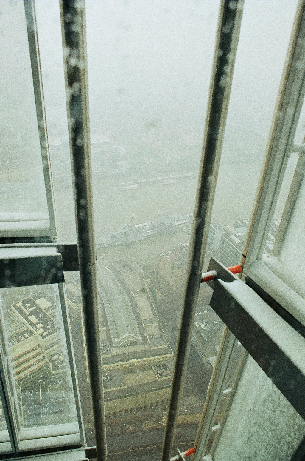
Anyone familiar with London, and asked what they think is the highest point, will probably offer up The Shard. Might they be right? Just for the record, I have been up to the public observation point of The Shard, with a friend, in a snowstorm so bad you could barely make out London Bridge Station directly below, and with snow drifts forming inside the viewing platform!
The View from the Shard when the weather’s pants!
We took the lift. At that moment, some years ago now, were we at the highest point in Greater London? According to Wikipedia we were (although of course we weren’t because there were a couple more floors above). But, when I came to write up this account (and rest assured it is not an account of how my friend and I paid for tickets and then took three or four lifts to the top of The Shard in a snowstorm), something nagged away at me. Could it really be true that this tower, with its base almost at sea level, be higher than the two Crystal Palace TV transmitters set high on top of Beulah Hill and Sydenham Hill some miles to the south? Due to the almost zero visibility on the day of the Shard ascent, it was impossible to make any comparison, and trying to get any clarification from Google has proved almost impossible.
At first, and instinctively, I was prepared to trust Wikipedia, but for whatever reason I expanded my research and doubts began to creep in. To cut a long story short (I made several attempts at it, having landed on a variety of confusing and sometimes contradictory sites), I came across what appeared to be a definitive and humorous account by Bron Maher (link below). *
Working on the basis that the writer of the article comes across as sincere and impassioned, I suggest that the highest man-made elevated point in Greater London, where the eagles fly, is the Crystal Palace television tower, erected in 1957 (a rather fine year I should add) at the top of Sydenham Hill in south London. At an estimated height above sea level of 330 metres the tower is about 27 metres above the top of the Shard. Thankfully, for this exercise, I don’t have to find a way to get to the top of the Crystal Palace television transmitter, because here we are focused on the highest point of land in Greater London.
Once upon a time you could live in any part of London and consider yourself to belong to one of the established Home Counties. Surrey and Kent south of the river and Essex and Middlesex to the north (I have no editor, so you’ll just have to hope this is correct). If, say, you lived in Deptford in south-east London before 1965, and gave your address, you would have added Kent at the end. Surbiton would have been in Surrey. Hounslow would have been in Middlesex and West Ham was in Essex. Surrey cricket club play at the Oval and Middlesex play at Lords. And so forth. No matter. Times change. Scotland was once an independent country. The Greater London Authority has existed as a political entity since 1965, but you could be confused for not knowing this.
So, getting back to the core subject (apologies for earlier wormholes), if you asked most people who know London what they thought was the highest point of land in Greater London, I am pretty sure that there would be a range of opinion. Primrose Hill is trendy and wrong, but the views of London are excellent. Others, depending on their geographical bent and possible prejudices, may say Highgate Hill, Westow Hill, Ally Pally, Blackheath, Muswell Hill or perhaps even Richmond Park. But Greater London is more than location, location, location. Beyond the noticeable clay and sandstone ridges of Hampstead and Highgate in the north, and Crystal Palace and Sydenham Hill to the south, the land gently rises again, stretching out towards the suburban rim and Green Belt. In the north, parts of Enfield, Harrow and Barnet reach over 400 feet. But the big hitters, towering a whole two or three hundred feet above the north London rivals, are far to the south, and beyond the view of most Londoners.
From central London one approach could be to head directly south-east and to one of the country’s largest and possibly least known post war council estates. New Addington is the size of a small town but is largely hidden from view. Whether or not that was a deliberate decision by the planners it’s hard to say, but as a teenager who occasionally ventured up Lodge Lane to meet with friends from school, it boasted one of the largest packs of stray dogs I’ve seen anywhere, and a rather fearsome reputation for violence (not including the dogs). Those days have largely gone, but whilst on a dreary winters day it still feels like a place beyond every other place (its colloquial name is “Little Siberia”), its fringes are surrounded by farm and chalk downland. If you can navigate through the estate and exit at the south-eastern end on King Henry’s Drive, you’ll soon get to Biggin Hill, and beyond that South Street.
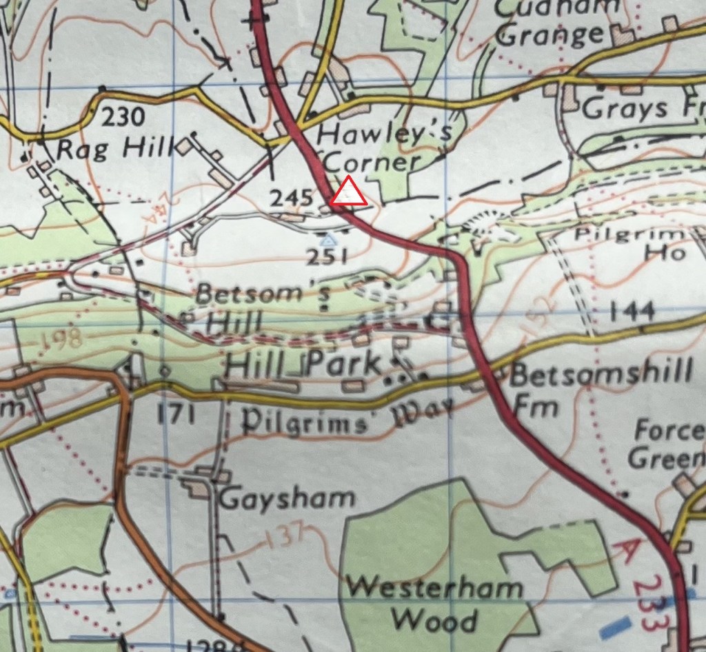
If you wanted a short walk to the highest point of land in Greater London, South Street might be the best place to park up (if you’ve driven). But I wouldn’t know, because I arrived at Westerham Heights from precisely the opposite direction and hadn’t a clue I had ticked it off until some months after tackling the highest point in Kent. When I was putting together the list of the highest county points (sometime after I had climbed Betsom’s Hill), it became apparent that at a point in that walk I had passed Westerham Heights by a matter of a road’s width. Located just beyond a hedge to the east of the A233, and on the opposite side of the road to Westerham Heights Farm (an obvious giveaway that passed me by on the day). If you want to read a short account of my inadvertent discovery of Westerham Heights, it’s contained in the first of these tomes, Cresting the County – Kent. **
Westerham Heights – At the orange triangle – approximately. The thick black dash/dot line marks the boundary between Greater London and Kent. The barely discernible blue trig point just below marks the highest point in Kent – Betsom’s Hill.
If you make it to the moment where a local resident points me in the direction of Betsom’s Hill, but also explains it cannot be accessed, that’s the spot. Curious that he didn’t mention the Greater London massive on his doorstep! I’m not complaining though. Two in one day and I didn’t even know it – Hey Ho!
There is a website called PeakBagger.com that I have since referenced a few times to check information, particularly on heights. Just to ensure I had indeed reached the highest point in Greater London I double checked, and in doing so noticed that the Westerham Heights link showed a few names of site members who had previously “bagged” it. It was the first time that it had dawned on me that “bagging” county tops was even a thing (I have long known that there is no such thing as original thought or action, but I was becoming increasingly aware that what I had assumed was, at best, a very niche activity, was actually a widespread pastime). I clicked on the last person to have made this trip. David Darby, an American judging by the list of 15k feet plus mountains that he had climbed, almost exclusively in North America. The highest was over 20,000 feet. At some point in his obsession, London came a calling, and he had to bag it. I wonder then what he thought when he arrived on the 19th of November 2023, having possibly travelled up through New Addington, clinging to the roadside hedges and hoping to live another second besides the 804-foot Westerham Heights. Well, I know one thing, from his records on Peak Bagger, he didn’t bag Betsom’s Hill. Poor research I reckon, particularly if you’ve come all the way from the States. Mind you, check out David Howell’s (who seems to have lived quite a life and has stratospheric ambitions), who, like me, completed the double on 2nd July 2023. The things we do…the things we do.
After cresting Greater London and Kent, and a couple of hours later, I arrived home, and soon after, for the one and only time in my life, watched in dismay the Northern Lights. Happy anniversary.
Having spent the weekend with my daughter and her partner in Bristol, and having successfully claimed Hanging Hill in South Gloucestershire, rewarding myself with a strong coffee at the Swan Inn at Swineford, I drove south down almost vehicle free roads through Somerset, then east Devon and eventually into Lyme Regis in Dorset. A couple of nights booked in the Nags Head before heading back east to see friends in Portsmouth, then home.
After booking into my small room in the Nags Head and then having spent a couple of hours near the sea front trying the fish and chips and a couple of pints of the local ale, I set off up what felt like a 45% hill back to the Nags Head. By the time I arrived, panting and crawling over the threshold, with one of the patrons saying to me “have you been out there the whole time?” to which I had no answer, I flopped at the bar, rationalising that I desperately needed a small whiskey before bed. With fortification in hand, I took a seat whilst the last of the punters supped up and left. On gazing around my eyes fell upon a picture on the wall. It spoke of more optimistic times and for a moment I felt privileged to be in this space.
Toasting the man
Lewesdon Hill, Dorsets highest point, was a thirty-minute drive northeast of Lyme Regis. I decided on parking up in the village of Broadwindsor, located just north of the hill. As I neared the village, driving along the B3162, a stationary police car was parked up on the road ahead. I drew up behind but was waved on. Just up the hill, a second police car was pulled over next to what appeared to be an abandoned car, and a couple of officers stood silently by, with arms crossed.
I drove on and within a minute was parked up in a small close to the south of the village. The weather was perfect. Almost too perfect. I had no summer clothing so chose to leave my coat in the boot. The OS Explorer map (116) showed a route out of the village and straight to the top of Lewesdon Hill. It required walking into the village, which was fine because I needed a snack and guessed that the settlement was just big enough to support a shop. Fortunately, there was a profusion of old-fashioned signposts, and on each the words, Village Shop, as if it was the biggest attraction in the area. Maybe it was.
Surprisingly, being a Monday, the small community shop was open, although in truth it was rather lacking in immediately edible stock. Reluctantly, (I had walked in and so walking straight out would have been seen as a tad rude) I settled for a rather unappetising looking vegan sausage roll thing, made by a large food company that rhymes with “balls.” The shopkeeper was almost certainly delighted to see the back of it, but hey, needs must.
After procuring the snack and a cola, I walked back up to the White Lion Inn (closed Mondays) and headed west on err… West Street. A small house on the corner had a stone sign above the door that claimed Charles the Second had stayed there for a night in 1651. What it didn’t say is that he was fleeing from Parliamentarian troops after the battle of Worcester and escaped the village dressed as a woman. Just the previous day I had stood at the top of Hanging Hill in South Gloucestershire where, eight years before, a large force of his father’s military sustained appalling losses against a Parliamentarian army, taking the high ground before retreating.
Perhaps more interestingly, Broadwindsor also had a 17th Century vicar called Thomas Fuller who, apparently, often had his congregation in stitches. Who wouldn’t have wanted to live in a place which, whilst plague, and the warring elite ravaged the land, had a Sunday morning comedy club? I have an image of Paul Merton standing at the pulpit and drifting off into a flight of fancy, although having read a couple of Fuller’s “jokes” I think it’s likely that these days we would struggle to understand the nuance. By the time Charles the Second sought refuge in the village, Fuller was no longer the vicar, so missed the opportunity to crack a line at the King’s expense.
West Street wound down a hill to a bend in the road (which headed on up beyond). A footpath sign pointed south and confirmed the evidence on my map. Passing between a handful of buildings the path crossed a sparkling stream before reaching a large gate, with fields beyond. So far, so good. The gate, of course, was locked. There was no sign to indicate why. I don’t get annoyed in these situations, but it happens too often these days and can be mildly disconcerting. I looked around to see if I was missing something and noticed a small track leading away to my right, following the stream and through some woodland. It felt a bit unlikely, but I was in no rush so decided to follow the path and see where it took me.
Which was about 200 metres. The path petered out as it became overwhelmed by marshy ground. A delightful spot, but for me it was back to the drawing board, which meant a retreat to the gate. I looked beyond the gate and eyed up the path that clearly led to the top. No sign of a bull. I looked at the map, which showed an alternative path, but which required beating back through the village. I looked around. No one was in sight, so without further thought I was up and over and then stepping boldly along the path.
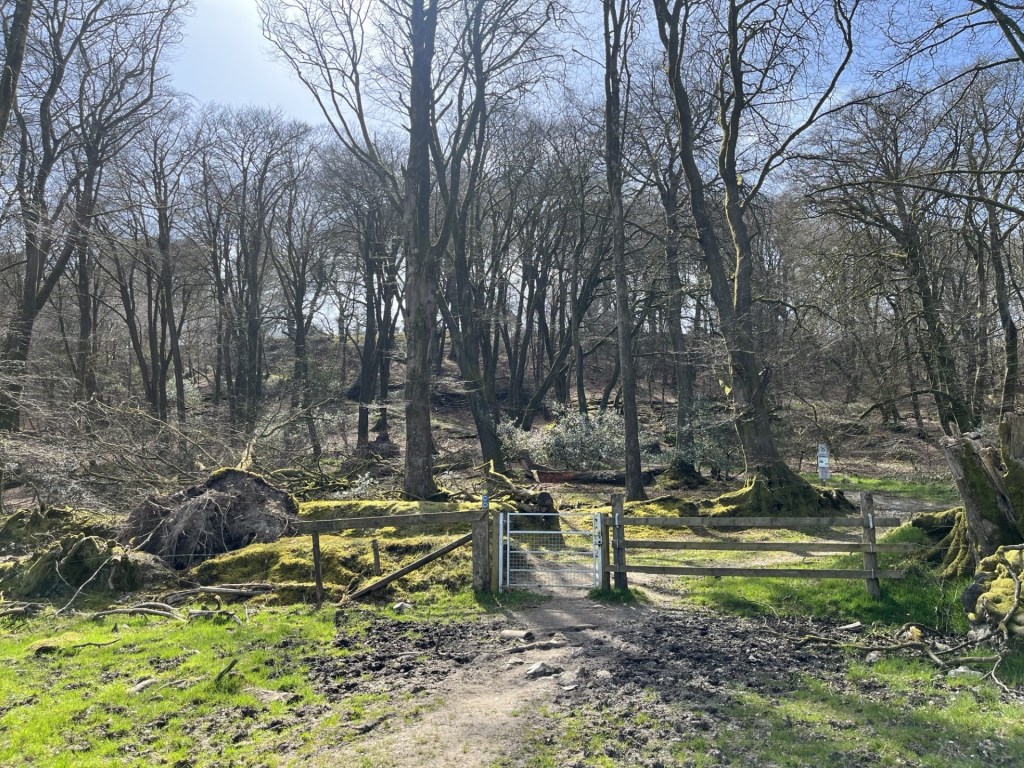
From there on it was reasonably straight forward, although at another locked gate a sign pointed east towards an alternative route, which I duly observed. After twenty minutes or so I arrived at a gate that marked the entrance to the Lewesdon Hill site, managed by the National Trust. Ahead lay dense woodland, with a variety of mature trees climbing up the steep slopes towards the top.
The approach to the enclosure
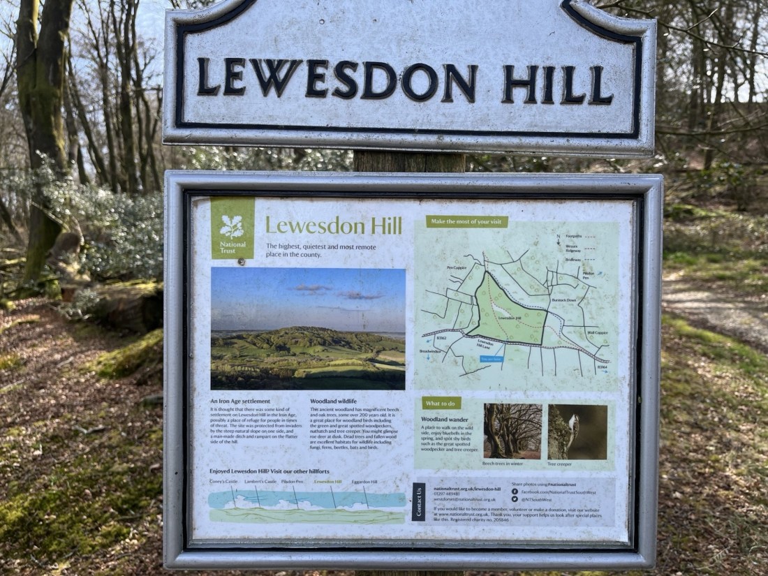
Proceeding through the gate, a large, mounted sign provided information about the area, the flora, the fauna and that an Iron Age settlement had probably existed on the site. That this seemed to be any doubt felt odd. It seemed to be a perfect setting. The board also stated that Lewesdon Hill was “the highest, quietest and most remote place in the county”. From what I had witnessed so far it felt a little bit like stating the bleedin’ obvious, but I wasn’t complaining.
A few steps on and a second sign. Slate grey, with the image of a Spitfire flying overhead in the top right-hand corner. I anticipated a sombre story.
In summary, on 15th March 1942, Jean Verdun Marie Aime De Cloedt, a Belgian in the RAF, in poor weather and with a faulty engine, crashed into the top of Lewesdon Hill. The commemorative board also mentioned that it was still possible to see the destructive path the plane had taken through the trees at the top. It felt like an unnecessary detail, but regardless it was a poignant tale. An intimate human story at “the highest, quietest and most remote place in the county”. Wars and hilltops. It was becoming a theme.
Chert stones that must have travelled down from above and onto the sandstone bedrock, scattered the path that headed south towards the top. Unusual, but would almost certainly have made this an attractive spot for early flint pioneers.
Within five minutes the path broke from the cover of the trees onto a heathy plateau and continued towards the only point that looked slightly higher than the surrounding topography. There was nothing of note to pinpoint the spot, but a hump of grassy earth seemed to be the place. I looked out to the south and towards the sea some miles away. Rays of sunlight swarmed through the large gaps between the trees. Looking down the steep escarpment the sun on the otherwise stark branches revealed the first, almost indiscernible, green blush of new growth.
From the top – Looking south southwest towards Morecombelake
Despite the delay in making progress at the foot of the climb, (due to the locked gate) I had made good time, and so after taking a few bites from the almost inedible vegan roll (cardboard wasn’t included in the list of ingredients, but I think it should have) I followed another path heading west and above the drop to the south. And a considerably steep and long drop it was too. Despite almost qualifying as a cliff, ancient birch and oak trees rose up from below, climbing and clinging on bravely to the thin earth. At some point it occurred to me that this was likely to have been the area where Jean Verdun Marie Aime De Cloedt’s plane had torn through the trees. I chose not to try and work out where.
Reaching the end of the plateau area another notice board gave more information, which must have made no impact on me at all, given that I can’t remember a word. A view opened out. The land fell away, but then rose again to the top of Pilsdon Pen, about two miles to the west, which even from a distance revealed features consistent with a hill fort.
West towards Pilsdon Pen
Scrambling down the north slope, on land recently cleared of larger trees, I was back on the main track which forms part of the Wessex Ridgeway and banked up to the right. The sound of a helicopter overhead intruded but tailed off as it headed north. Soon I was back at the entrance with the information boards, and after a quick look back set off across the first large field. I had noticed on the map that at the end of the field another path veered to the northeast and past Fir Farm. This was a more direct route back to the car and avoided having to negotiate the closed gate.
Objective Broadwindsor
By a large farm building I found what appeared to be the route, heading into some woodland. The noise of the helicopter should have long gone by now, but it was still audible, somewhere just to the north. Entering the woods, it was evident that the trail was little used. A sign had been attached to a tree, informing people like me that due to storms the previous year some of the trees were unsafe and walkers proceeded at their own risk. The sign itself was a year old, and I figured that the landowners would, by now, have taken the necessary action to make the area safe.
This was a lovely spot, a proper dingle dell. A low wall appeared ahead, with a nook cut out to allow the traveller to cross with ease. As I stepped over, something about its appearance had me confused. What kind of stone was this? I looked more closely. What I had thought was a stone wall was in fact a massive fallen tree, so embalmed in moss and lichen that it mimicked a human structure.
Not exactly sycamore gap, but art in nature nevertheless.
Carrying on down through the winding path the noise from the helicopter began to increase, annoyingly. Perhaps it was the military on manoeuvres, or a crop being sprayed with agent orange. Either way it was taking the edge off the afternoon. A bit further on and the path began to flank a track leading back to the farm. Looking ahead something stopped me in my own tracks. Through the trees and hedges, and about 200 metres further on, I could clearly make out the intermittent red and blue lights of a police vehicle.
In the 1935 film, The 39 Steps, Richard Hannah (Robert Donat), is on the run on a Scottish hillside when out of the blue (and out of all context given that Buchan’s novel was set before the Great War) a helicopter appears, hunting him down. Now, I should say at this point, nothing remotely interesting has happened to me for a very long time, although two evenings earlier in Bristol I had witnessed what might well have been a stolen motorbike being crashed at 5mph, and completely bizarrely, into a wall, before a car pulled up and swished the fallen rider away. Surreal. Nevertheless, and just for a moment, with the sound of the helicopter above, and knowing the cops were hovering somewhere just down the lane, my thoughts were suddenly hinting at the prospect of a manhunt! But who, and why? Was it fight or flight time?
Momentarily I engaged in mental research. Who was I? Robert Donat, Kenneth Moore, or, controversially, Robert Powell. I settled on Robert Powell, largely on the grounds that I had liked him a lot alongside Jasper Carrot in the TV show The Detectives. Now all I had to do was to get past the police checkpoint. Did I have my papers? It’s essential to have papers on you in these situations. I patted the inside pocket of my jacket. Hmm… would the Nectar loyalty card suffice? I was about to find out and started to walk purposefully towards the blues and twos.
I noticed that the police car lay beyond another vehicle and realised that I had reached the point I had passed in the car on my way into Broadwindsor. Whatever was going on seemed most particular. I reached the end of the drive and volunteered a “hello” to the two officers idly guarding the mysterious car. I think they may have said something back, but either way I wasn’t subjected to any stop and search, or interrogation, for which I was most grateful, although as I carried on along the road back into town, with the helicopter still bothering around above, I wondered whether the officers might have been a tad neglectful in their duties.
Back at the car I checked the app which had been recording the walk. 2.79 miles. 411 ft elevation gain. 670 calories. 8k steps. No more, no less. Oh, for 39 more! But never mind, for an hour or two, in a remote part of Dorset, which had once been the home of “Have I Got Sunday Morning News for You”, I had been away from the numbers.
A beautiful Spring morning in Bristol, and a few hours to spare with my daughter and her partner J, before heading south after a short but very enjoyable weekend visit. They were both aware of my growing interest in seeking out county high points and indeed had previously enabled me to the tops of Ben Nevis and Snowdon. Was there somewhere locally where a short walk could take us to another county top? Well, up until a few weeks earlier I would have said no, and time was too short to hop over to south Wales. But that was before I had discovered a new county (or so I thought).
In October 2024, when I had climbed Cleeve Hill, I thought I had ticked off Gloucestershire. As winter came and held me in the grip of my local area, I found a map of British Counties online and ordered it. When it arrived it was exactly what I had in mind. Very simple, with the key information, and massive. I bought a large piece of plywood and carefully mounted the map using double sided tape. Now, all I had to do was work out a methodology of categorising the high points (by height obviously, but also by geology, for no other reason than to complicate the process), and then begin to annotate it as and when a new cresting occurred. I should say at this stage that it’s become quite a complex beast, and I’m a while away from any annotation, but something happened a few weeks ago that radically altered the dynamic.
One of the joys of having a huge, mounted map is that it’s easy to look at and take in geographical relationships and direction. When it comes to looking at maps on my phone, or on a PC, my spatial/visual awareness seems to go out of the window. I guess I was just born too late but give me a map in the hand and by and large I feel like I am in control. Of course, I couldn’t fit this map into my hand, but when I was planning the weekend in Bristol I had sat down and looked at the big one to see what counties might provide opportunity, either on the way there, or on the way back. It all seemed straight forward, until err… until, just past Wiltshire (yet to do), appeared a county called South Gloucestershire. What the what the?
South Gloucestershire wasn’t on my original list of counties, but sure enough it exists, as a Unitary Authority since 1996, and after the abolition of the previous authority of Avon. Whether or not including it in the itinerary is open to debate, but it was on my map and delivers all the services provided by Gloucestershire council to the north. It couldn’t be ignored and given that its high point was just a few miles to the east of Bristol, I offered up Hanging Hill as a short walk option before parting company.
We drove out of Bristol on the A431 (Bath Road), and just before the Swan Inn at Swineford turned left and along a track through a farm, pulling up at a small, very serviceable and free, car park set in a thicket of trees. You don’t get many of these for the pound these days, but without the need to have a ten minute confrontation with a pay by phone pay and display machine, I wasn’t complaining. J had done the research, and we set off east, past an old mill stream, and then into a large field with what appeared to be free range ostriches in the one adjacent.
Passing through a line of trees we entered another field, with the path then rising steeply until reaching another tree grouping flanking an ancient drover’s lane. The track, with steep banks on either side, continued up, but without being obvious, started taking us southeast, and away from our objective.
Steeply hollow
After plodding on up for nearly half a mile a path leading away from the track appeared to our left. Following a straight path we entered the seemingly exclusive hamlet of North Stoke. A road continued taking us east. A small red-letter box set into an impressive stone wall forming part of one of the more impressive buildings gave rustic charm. Continuing on and then left again past the modest but aesthetically pleasing St Martin’s church, we started to ascend another steep track that formed part of the Cotswold Way.
I should just say that, having stripped off various layers, and now down to my T-shirt, I hadn’t expected to still be climbing UP at this stage! I hadn’t really been paying much attention to the route and had assumed that we had parked quite close to Hanging Hill. I made my first inquiry whilst panting at each weary step. “Are we nearly there yet J….?”
Reassuring noises came back. Suitably reassured, I found a new lease and before too long (at least another half mile!) we reached a bench next to a gate leading onto a golf course. We were now on the Cotswold Way and that meant more walkers. A shame for me as out of nowhere an enthusiastic group appeared and colonised the very bench that, as we had approached, I had coveted over the previous two minutes.
We stopped, standing, to get our breath back (well, that’s what I was doing at any rate) and took in the impressive panorama looking west and towards Bristol, the Severn, and the Welsh mountains beyond. From the lie of the land, I assumed that we weren’t too far. “Are we nearly there yet J….?”
J consulted his phone. “Yup,” he replied. “That’s it just over there.”
Of course it was…
I looked north. The land fell away steeply into a valley and then rose again towards a clump of trees at the end of a ridge. Just over there, yup, about a mile just over there (as the crow flies). Now, I had all day, but it was a Sunday, and I hadn’t wanted to eat into too much of my hosts remaining hours before their new working week. If, at that moment someone had said that getting to Hanging Hill was going to take too long, I would have surrendered the task there and then, to return another day. But nothing was said and so we continued on, flanking a pleasant looking golf course to the right and woods to the left. At least now we were on the flat.
Just past an old farm building, in a fallow field, a collection of metal fantasy sculptures had been let out to rust slowly in the elements. I’m not necessarily a fan of “industrial” art, which I find somewhat contrived (I can’t find an emoji of Morrissey, but if one exists, insert here), but on this occasion I was suitably impressed. Something about the location perhaps, but also the aesthetic and the way the Grim Reaper with dog, and other Tolkienesque characters had been positioned pulled me in. I considered taking a closer look, but time was pressing, and the need was to move on.
Sculptures by David Michael Morse – Deceased
The track continued up to a crest, with the golf greens now on our left. We headed northwest, still on the Cotswold Way. A delightful wood, covered in a carpet of thousands of wood anemones stretched out to our right. A suggestion to wander through these woods was vetoed. We appeared to be at the limit of our time window. The greens we passed seemed to stretch forever, and judging by the disastrous tee-shot swing (and hope) by a possibly hungover weekend golfer at the nearby tee, his game was going to be a stretch too, far.
Here the course ended and just ahead a gate beckoned us into a large field that vanished to the horizon, which was dispiritingly far away. By now there was a palpable tension. I’ll leave out the details, but entertaining the old man’s cranky new hobby had clearly run its course, and I had run out of credits. We had come too far to turn back. My own assessment of the land and the area suggested that we could make a dash back to the cars an alternative way, but for the moment it was important that I focused solely on apologising with conviction for my selfishness and trust for the best!
We crossed over the large field, a path clearly pointing us towards our destination. Minutes later, and to my overwhelming relief, we reached the trig point that marked the top of Hanging Hill. I was tempted to say we didn’t hang around, but sensibly we stopped and took a five-minute break. Hanging Hill? No idea. The next one to the north was called Freezing Hill. You get the medieval idea here.
Just hanging around. Trig points are handy things to rest on.
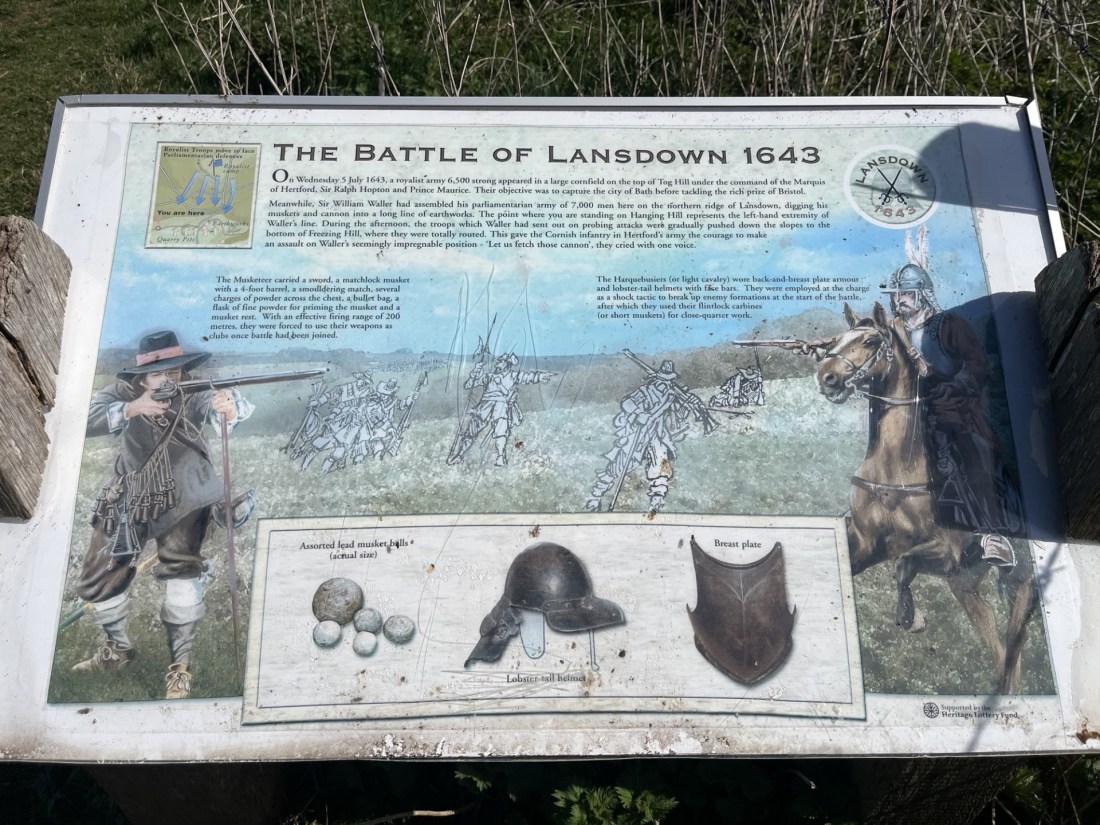
Just past the trig point, an information panel told us a bit about the Civil War battle of Lansdown, fought on this spot in 1643. With time pressing I chose to take a photo and read it later.
Limited information
This is not a history lesson, and in truth, as I found out later, neither was the information panel. * If we had had more time, it might have been possible to survey the scene and appreciate more the scale of the carnage that had occurred here four hundred years earlier. But the research would have to wait.
The killing field
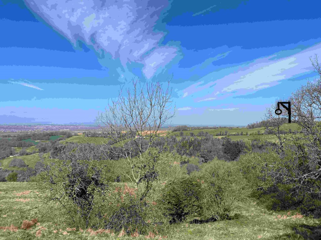
The prerogative now was to get back to the cars as sharp and as shipshape as possible. We’d been out too long. The good news was that it looked like it was going to be all downhill from now on. Except we chose to set off northwest, heading away from where the escape vehicles were parked up. We trod carefully down a steep track through dense woodland, with the first signs of new growth all around. With continuing murmurings of discontent amongst some of the team, I quietly hoped the correct decision had been made. The track continued for, in my mind, too long, but eventually we spilled out onto a narrow road, and despite some hesitation decided to bear left and head west.
Marshfield Lane proved to be the win bonus of the day. Hardly a vehicle passed us, and progress was swift. A bank to one side of the road stretched for some distance, covered by hundreds of yellow primroses. Soon after we were passing the rather appealing looking Upton Arms in Upton Cheyney. No time though to contemplate the achievement over a coffee or cold drink. Onwards and downwards on Brewery Hill and then, at a sharp bend in the road, we followed the footpath directly down through a farm, then through a gate, and within minutes we were sitting in the garden of the Swan Inn at Swineford, the sun beating down and all was right with the world.
Mothers Day at The Swan Inn Swineford
It had been a longer hike than anticipated, with an unexpected, almost continuous 700 feet of elevation from the start to Hanging Hill, and much tougher than expected. Just under five miles, but thoroughly worth it, and in the end we were all still friends.
* The battle of Lansdown hill makes for an interesting read. Not that you would necessarily have known it from the information board, which gave the impression that the Royalist forces inflicted a crushing defeat on the Parliamentarians (under the leadership of Sir William Waller). The forces appear to have been pretty evenly matched, with Waller’s troops dug in at the top of the ridge, his left flank at the trig point. A fuller account is provided in the link below, but in a nutshell, it was a long and hard-fought battle over many hours and into the night. With ammunition low, Waller chose to retreat to Bath in the dark of night. With ammunition low but having sustained severe casualties (not least to many of the commanding officers), the Royalist forces gave up the chase and set off to Oxford in disarray. It had been but a pyrrhic victory for the Royalists. The two sides met again for a rematch a week or so later at Devizes, where the Parliamentary forces were soundly beaten after Royalist reinforcements arrived in the nick of time. The losses at Lansdown Hill are speculation but the estimate is that on the Parliamentarian side, 20 troops died, and 60 were wounded. Multiply both those figures by ten to get an idea of the scale of the losses on the Royalist side, not to mention the high casualty rate amongst its senior officers (Wikipedia). It must have been a brutal and bloody affair, with deadly skirmishes taking place between infantry and cavalry in the woods that we had walked down through. Sobering indeed.
After I read the fuller account of the battle, I was able to picture vividly what the calvary and infantry clashes in the woods above Marshfield Lane must have been like. Loud, close and very bloody. This very rarely happens to me at any historic battlefields, where it is impossible to imagine mass slaughter in a vast corn field. I also realised that, other than a superficial understanding of the English Civil War, I really knew nothing about it at all. Given not just the struggle, but also the fundamental principles involved and how it changed the world, within the week I had bought The British Civil War – Trevor Royle. With 900 pages I may come to regret the purchase, but without seeking out the highest point of this unitary authority, my ignorance would remain complete.
A couple of weeks earlier, whilst searching for the true top of Hertfordshire, I walked adjacent to a linear section of one of the Grim’s Ditches; iron age earthworks associated with the Chilterns area that still remain a mystery. I discovered that I still owned a fifty-year-old copy of The Old Straight Track, in which the author, Alfred Watkins, claimed, in 1925, to have discovered multiple ancient lines in the landscape. These were called ley lines, based on man-made and natural features, such as burial mounds, churches, standing stones, springs, and other features, which align on the land. I wanted to find out if he had a take on the Grim’s Ditches. He didn’t. I wondered perhaps if this was because they might have undermined his theories, but it’s more likely that he had little knowledge of them, being that most of his research was conducted in the Herefordshire area where he lived, and in particular the Radnor Valley.
Having decided to rule out a late summer getaway to Greece, on the grounds it was going to be too much hassle and inflated prices that didn’t reflect the quality of the accommodation, I decided instead to book a few nights in a studio near Great Malvern, and go seek out some end of season county summits. Given that I was not going to be a million miles from Great Malvern, logic dictated that a walk in the Malvern Hills, and to the top of Worcester (or Worcestershire) Beacon, would make a good start. I packed my bags, threw in my copy of The Old Straight Track, took on a 48-hour grandparenting shift in Bedfordshire, then drove across the Midlands in torrential rain and arrived on Tuesday evening at my digs in the foothills of the Malvern Hills. It was mid-September and unseasonably cold. Wondering if I should have put a bit more effort into the Greek thing, despite the conditions, the late evening view of the hills had me smitten.
After a solid night’s sleep I drove into Great Malvern and parked up just out of the town centre. I was anxious to get on with the walk, and after about 200 metres I realised I was still wearing trainers and not my walking shoes. There’s a difference. As I turned back towards the car park, I also remembered that I hadn’t paid for that either. It’s possibly a getting old thing, but I do need to pay more attention to detail. As it happened, and unlike some other locations I have visited recently, paying at the machine with a card, and without having to type in a load of detail, was a small joy. That said, the 1-hour, 2-hour, 4-hour and 10-hours options (where was 6 and 8?) left me having to select the 10-hour option, just to be on the safe side. At £4 it seemed a fair deal.
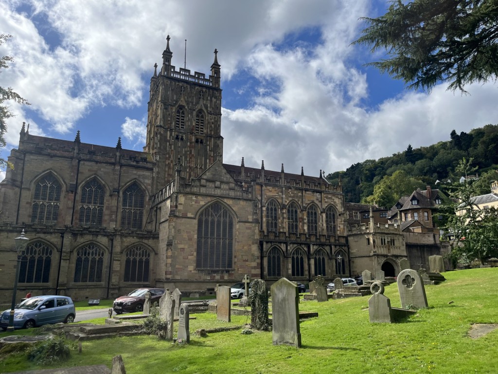
Re-shod, I trotted up the high street and soon arrived at the grounds of the Priory. I knew I had been here before, and had done a walk in the hills, but for the life of me I couldn’t remember when, with who, or why? Maybe it would come back to me as they day progressed. (It didn’t).
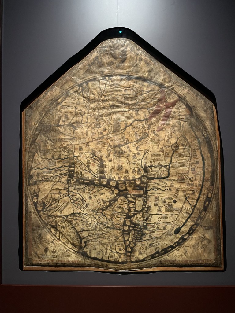
Given that I had 10-hours on the meter I felt I had nothing to lose by dropping into the church for a closer inspection. In the back of my mind I had a thought that it housed the original, or at least a copy of the Mappa Mundi.
Into the Priory
I stepped inside, avoiding the curious eyes of the volunteers, eager, no doubt, to pounce. I briefly took in the ceiling tiles and the stained-glass windows that an information board informed me had somehow survived the Dissolution. Another sign said that it costs £20 every 15 minutes to maintain the church. In 1541 locals raised £20 to buy the whole thing to replace their old, dilapidated church. There was no sign of the Mappa Mundi. *
I moved towards the centre of the building. As I did so I became aware of a small gathering at the far end, and a person of the church dressed in a gown, giving a service to a group of people. He was wired up and I was able to hear the reading. I had no idea what the message was, but I did pick up on the line “O ye of little faith.” Taking it as a cue I chose to leave and head instead for a higher place.
The vicar (?) had obviously seen me coming and had slipped in what I took to be an ecclesiastic diss. Duly patronised, I left without further exploration and headed up to Bellevue Terrace, the holy cuss still ringing in my ears. I noticed that there was an abundance of greeting card shops, and as I headed north along the A449 another card shop boasted that it had been nominated in the Best Independent Greeting Card Retailer in the Midlands! Who knew?
I had no specific route in mind, but figured if I continued along this road I would be able to walk the ridge from one of its northern entry points. Here, the A449 is the Worcester Road. Occasionally, between the grand Georgian and early Victorian mansions that lined the road to the right, tantalising views opened towards the Vale of Evesham. The people who built and lived in these imposing houses had certainly picked their spot.
After half a mile or so I took a left onto West Malvern Road. The road went up here into the Cowleigh area (I knew it was the Cowleigh area because a sign pointed out that it was the Crowleigh Area), and after another half mile, on the left at North Quarry, a small car park and what was obviously a route to the hills. Starting up the path on the left I spotted a blue plaque on the wall of what appeared to be the last house in town, and dedicated to Alice Betteridge, the last donkey-woman of the Malvern’s. Rather than jumping to improbable conclusions, I figured that perhaps some more context was necessary.
The steep path headed back south, with a sheer drop to the left of what was obviously one of the huge quarries at the north end of these hills, now overgrown. After another half mile or so, the path began to level out, then a sharp right and it began to zigzag up through oak woodland. After twenty minutes or so I was suddenly out of the trees, the ridge opening out to the south, and down to the left Great Malvern and the priory, abbey, church, whatever, and where, no doubt, the faithful were still celebrating the earlier eviction of the heathen intruder.
Heaven’s Above..
I had an option on the path here. Left, or right and back on north. I sat for a while on a stone and took in the view. Nearby, three young men in modern outdoor wear were discussing the view. One appeared to be in charge and was making encouraging noises to the other two about how they were getting a grasp on what they were seeing in front of them and how that translated onto the maps they were holding. And they were beginning to get it. I figured that it must have been part of a mobile phone detox project, and frankly I’m all in favour. I could see a train heading directly towards me along a straight bit of track, and beyond, Worcester. Time to get on.
I should perhaps say something about the weather at this point. It was bright and mainly sunny, which should have been good, but very unusually for this time of year an arctic blast was brewing up and, like Napoleonic troops in column after column, banks of clouds marched relentlessly overhead from north to south. One minute I was in sunshine and down to my T-shirt, the next rapidly re-dressing. Based on the years weather to date, how it hadn’t rained so far remained a mystery.
They came on, in the same old way
Following the path around the northern flank, with the tops of a hundred hills in every direction, a route up to the top of North Hill presented itself. It was clear at this point that I had missed a trick. If I had carried on past the North Quarry car park, I would have been able to start the climb of the granite ridge at its most northern point. Too late now. I pushed straight on up the steep bank, eventually arriving on level ground with Worcester Beacon directly ahead, and the ground rising again to the left and right.
Looking south. Worcester Beacon – the main objective
Without giving it a second thought I went right, and up. At the top I looked over to the east where North Hill was obviously slightly higher. A minor detail, but for a purist it might have been important. The path then descended rapidly to a saddle where I sat for a while and watched a kestrel looking for its lunch. Already the views were of the highest quality. Far to the west I could make out the Brecon Beacons, and the unmistakable conical shape of Sugar Loaf (which my daughter, her partner and I had climbed in early May, and where the idea of scaling county tops had been kindled **).
Having chosen to approach the summit from the west, as I started on the long drag up, the wind, angling in from the north-west began to tell. Layers were going back on, but it mattered little as the views towards Herefordshire, and Wales beyond, just got better and better. The granite ridge of the Malvern Hills runs precisely north/south, and similar but slightly lower ridges on similar alignments could be picked out to the west.
Approaching the summit the wind was beginning to blow a proper hooley. Clumps of grass were being driven flat to the ground and I was beginning to flag. Spotting a cave just above, and needing some respite, I clambered up a bank and entered. It provided little or no extra protection. I took a quick photo and fled. With the broken grey, blue, pink granite beneath my feet, I made the short drag to the top as quickly as I could.
A cold hole
At the summit I might as well have been standing in a wind machine set to max. A circular plinth, erected sometime in the 19th century, and honouring some monarch or other, who I am absolutely certain never visited this spot, marked the top. I stood in the gale for five minutes, watching, through steaming eyes, a group of four middle aged men take innumerable photos of each other. Wishing them to give up the land to allow me a brief second or two at the top, eventually I butted into the party and looked at the large circular toposcope (new word) on the top of the plinth. With my eyes still streaming, and feeling like a gate crasher, I had no time to take in the details except to note that Snowdon was 99 miles away, and in the direction where the wind was thwacking in from. With my hands and whole body shaking I took a photo, figuring I would study it in more detail later. When I checked it later it failed to pass muster, so you’ll have to make do with a couple of panoramas instead.
Having made it to the top I slipped over to the calmer east side of the ridge. Heading south, and with the wind less of a factor, this was walking for the sheer joy of it. The views in every direction were phenomenal. Bit by bit the paths began to descend, and aware that I would soon be losing these astonishing vistas, I sat for a bit above another abandoned quarry. Given the amount of excavation evident, closing these quarries some decades ago was probably for the best, otherwise the chance of there being anything left of the hills now would be remote.
Looking to the south-east, something in the valley below caught my attention. I long, straight line in the landscape! Before leaving the accommodation in the morning, I spent a bit of time mugging up on Alfred’s Watkins understanding of the Malvern Hills area. Surprisingly there wasn’t a lot to go on, although he speculated on a possible ley line starting on a point on the ridge further south which aligning with a cave and a stone below, before disappearing west to an oak tree at Gospel Oak (not Camden’s), and then through two churches and ending at Aconbury Camp (you’ll just have to use your imagination unless you decide to disappear down a rabbit hole). ***
In search of ley’s
The observed long, linear ditch in the landscape, flanked by a line of trees (Watkins advocates strongly about trees and their relevance to ley lines), made me reach for the Ordnance Survey map. Had I discovered the yet to be discovered Malvern Wells/Bredon Hill ley? I immediately located the line on the map, represented by hatched marks. Incredibly, I could track back to the Hills and a starting point where a tumulus was shown on the ridge. Heading further east, beyond the avenue/ditch, the ley precisely crossed with a mediaeval bridge at Upton upon-Severn and ended (as far as I could tell) at the very top of Bredon Hill, some six or seven miles further east. The most extraordinary thing about this ley line was that between Upton upon-Severn and Bredon Hill, it exactly bisected the southbound Strensham service station on the M5 motorway! What otherworldly powers were at work when that happened? With the map flapping away in the wind, and with my mind blown even further, I took one last glance at the linear feature on the map. Huh! I looked again and sure enough I could make out some cryptic writing – dismtd rly. How could I have been so foolish? Or maybe (surely not), when the Great Western Railway built the line almost two hundred years ago, those working on the ground were more in touch with nature and……. (goes on forever).
With these thoughts dancing around like fairies in what was now left of my brain, I wandered on and eventually reached the end of the northern section of the hills at Upper Colwall (essentially there is a northern third, a central section that ends at Little Malvern, and then a southern third that starts at British Camp and tails off a few miles further south beyond Hollybush).
A road crossed my path at the saddle of the hill. I was still in the mood to explore further south, but every step in that direction would mean a longer shift getting back to Great Malvern. A sign indicating a cafe downhill to the west tempted me in that direction. On a lamppost a yellow AA sign directed travellers onwards to the National Collection of Michaelmas Daisies. I hadn’t the foggiest notion of what a Michaelmas daisy might look like, although daisies came to mind. It would either be very nice, or niche, or intriguingly maybe both. I headed on down towards a building that housed the cafe, and with nothing other than an invigorating cup of tea on my mind, reacted almost too slowly when the door of a parked car shot open. Being taken out by a stationary vehicle at this point in the journey would have been a tad disappointing, but somehow my body reacted sufficiently to avoid a painful impact. The perpetrator looked more startled than I felt, apologised profusely, and delightfully an incident of footpath rage was averted.
Reaching the building, still slightly shaken, but grateful that I hadn’t been on a bike, it was disappointing to find the cafe closed. On the flip side, a sign on the window indicated that it hosted the British Society of Dowsers. Now, that was niche! Watkins, whilst not claiming that dowsing assisted him in any way in his search to prove the existence of ley lines, does, in his introduction, indicate an affinity with the ancient craft. It helps form the narrative that humans are intrinsically more in touch with nature and the earth than we understand, and that essentially, we have lost our ability to interact with nature in ways that our ancient ancestors were.
I am not going to suggest that I completely reject that notion. Things do happen, and well, you know! When I was around 15 years old, in the early 1970’s, one afternoon after school a few of us were hanging around on a green on the estate, aimlessly doing what aimless teenagers do. Nothing. A friend, Jim, was arsing around with a Y shaped stick. Shaking his arms around he claimed to have discovered an underground water source, which on closer inspection was a metal cover to a drain owned and managed by the local Water Board. Just at the point when his antics were running out of steam (i.e. everyone had lost interest), his wrists began to gyrate frantically, and the stick pointed in the direction of a manky stray dog that was approaching across the grass. “Leave it out Jim,” someone shouted, at just the moment when the dog, now just feet from him, stopped, cocked a back leg, and did his business. It was proof enough.
With the idea of a refreshment now deeply embedded, I climbed back to the top and followed Old Wyche Road over the saddle and in the direction of the town. Not far on stood The Wyche Inn, so naturally I went in, bought a cola and a bag of crisps and sat in the warming sun. Refreshed, I set off north on the road back into town. More grand houses lined the right side of the road, and more old quarries kept appearing to the left. I hadn’t particularly relished the idea of the last leg, knowing that it must have been at least a couple or miles or more, but in what seemed to be a blink, I was at the outskirts of the town and with just a short distance to go. I looked between two large houses and across the Vale of Evesham. Whilst the sun still shone, a monster storm was tipping millions of buckets of water into the Severn valley. At such moments, and given the location, a touch of Elgar dancing in the air from one of the grand Edwardian windows might have been appropriate, but as I knew no Elgar, and all the windows were firmly closed it remained an enigma and the moment was missed. Alert to the danger I quickened my step, slid down an alley just as the edge of the storm arrived, and in the nick of time found dry sanctuary under the arch of a church door. The downpour was over within a couple of minutes. No dowsing was required.
Two hours on and I was walking across Castlemorton Common towards a local inn. I stopped and looked back towards the Malvern Hills. I’ve never been there, but something about the view reminded me of an African savanna.
Castlemorton Common – AKA The Worcester Veldt
In his quest to prove the existence of ley lines, Watkins frequently encounters rustic “locals” enjoying a pint of warm beer at country inns. In these moments they recount to him stories that he tentatively claims endorses his understanding of a nearby feature, such as some standing stones. Almost always the narrative begins with something like, “Of course, they’s do says around these ‘ere parts tha’ when a red moon rises over the Blattered Elm, the three Plastered Knights of Old Pishup do rise from the earth, climb up the walls of Cwm O’rbard Castle and there do take an ancient brew from the larst well of Uncertain Origin.” Underestimate at your peril this type of verbal history. Watkins, keen to latch onto any old tale (sorry, fact), certainly didn’t.
On the drive back from the hills I had stopped at the inn to check if it was open, and more importantly, doing food. As I approached the front door it opened and out stepped a middle-aged man holding a pint of the local ale, wearing agricultural clothing, with long curly hair and beard, a ruddy complexion and a rollie between his left earlobe and sideburns. I entered the pub, which clearly hadn’t changed one bit in decades, and was told that they would be serving food after six, and that was fine by me.
As I approached the inn on foot, just after six, I was certain, and excited by the prospect, that if I stayed there for an hour or two it would only be a matter of time before one of the old locals (possibly even my man from earlier), in true Watkins style, would enlighten me on a local myth or legend. I entered at just the moment my man was leaving for the night. The pub was now half full, and everyone, builders, buyers, businessmen and women alike, were gazing intently at their mobile phones.
After a satisfactory pint of Best and a hearty meal, it was time to head home. As I approached the door the woman behind the bar wished me goodnight, and then, as an afterthought added, “Oh, and sir, do mind the old stone on your way out.”
*
* Seems the Mappa Mundi is in Hereford Cathedral. Two days later I took a train to Hereford, found it to be a pleasing town, and spent an hour in the excellent cathedral library, where the Mappa Mundi can also be found hanging, more or less, intact.
Hereford is bottom left, just next to Crete
** Sugar Loaf is the highest peak in Monmouthshire. But Chwarel y Fan is the highest point, which means that sometime in the future I will need to revisit Monmouthshire. Mind you, worse things can happen.
Sugar Loaf in May – Not the highest point in Monmouthshire!!!
*** Two days after the walk I had time to climb up to Herefordshire Beacon (British Camp), at the start of the southern section of the Malvern Hills. Not surprisingly it’s located in Herefordshire, and despite being quite high, is not the highest point in that county so I can’t claim it. But I would have kicked myself if I had not chosen to do it. The most spectacular Iron Age hill structure I have ever been to. As it was late in the afternoon, and with the sun setting, the views were mind bending.
Beat that!
With a bit of time on my hands I walked south, and with Watkins alignments still troubling my imagination, I eventually located Clutters Cave (AKA Giants Cave). The area below the cave was heavily overgrown, with two green woodpeckers flitting between the trees. I had no desire to go rooting in the brambles for what he believed to be a sacrificial stone that formed part of the ley line.
Alfred Watkins mate, being sacrificed a hundred years ago. These days it’s called sunbathing
I entered the cave and was immediately struck by a ghostly black handprint on the back wall. Clearly evidence of neolithic cave art, and I was surprised that Watkins hadn’t noticed or mentioned it back in 1924. Or maybe it was a Banksy? Either way, and whatever the explanation, I looked out from the cave, and with the dipping sun blushing the Welsh borderlands, I could easily see how it was possible to hang a mystery around the location, and speculate on a time when our ancestors navigated astral planes rooted to points, natural and manmade, on the landscape.
It’s all in the mind, or is it?
A mile or so to the west, below the ridge, lies Eastnor Castle and park. Except it’s not a castle at all. It was built whilst Napoleon was meeting his match in Belgium. As there is no mention in any literature or works of art of Clutter’s Cave before this time, it seems pretty likely that it was dug out to form an estate folly. Sorry Alfred, but not all the leys align after all.
I’ve struggled to work out how to start this relatively short narrative. This is an account of how, in the middle of August I walked to the top of Buckinghamshire, and then Hertfordshire, in just over a couple of hours. But, for the sake of the purity of the project, do I separate these accounts or not?
Whilst I’m working on how to square that circle, here’s something to think about. Trusting, or not, in information on the internet in respect of the accuracy of heights and locations will, I’m sure, feature somewhere.
I have decided to stick to two separate accounts. This is the account of a walk from my car to the highest point in Buckinghamshire. Having reached that point I then carried on into Hertfordshire. That slightly longer tale can be found here
A couple of weeks earlier I had been contacted by an old work colleague suggesting a meet up in London. It had been some years and sounded like a good idea. I had suggested Wednesday 21st July and had made an arrangement to stay with my youngest brother in north London the night before. Unfortunately, the next day my old colleague had to cancel, and so I had an option of going straight home on Wednesday, or, oh yes, a short drive out of north London, then the M25 west and up the A41 and lo, two adjacent high points were available just west of Tring.
On the day it was a warm and sunny morning. I drove into the Tring salient on the A41, and then took a left onto the B4009 toward Wendover.* A mile or so on and a left onto St Leonard’s (a small lane heading up into the woods), and then just before Chiltern Forest Golf Club, a right onto a one way lane that, after a long and winding drive, eventually got me to the large car park at Wendover Woods (where your registration is filmed and you simply pay before leaving – nice!).
I’d opted for the T-shirt n’ shorts look for the day’s tramp, and after donning the walking boots I set off with a 1983 Ordnance Survey Landranger map, a bottle of water, sunglasses and a sun hat. I walked to the very modern and attractive restaurant/coffee shop, found my bearings and walked east and onto the exit road from the car park. Woods of mainly beech stretched away in all directions. After just a couple of minutes, and just before the barrier gates that released the cars that had paid, a break in the fence and a small track led into the forest on my left. A sign indicated that the full path was closed due to trees presenting danger, but that it was still possible to access the cairn. A cairn? Sounded impressive. I looked forward to the sweeping views across Buckinghamshire.
A well-defined path wound through the woods, and then, there it was. Four large stones, three laying down and one standing stone in the middle and surrounded in every direction by trees and heavy undergrowth.
A gathering of stones
A metal plaque informed me that the stone arrangement marked the highest spot in Buckinghamshire and that it had been erected by the Royal Air Force for the local Parish Council in 1977 to commemorate an infamous event that took place that year.** Early June if I remembered correctly. The plaque bore alarming indentations that indicated it had been used for target practice at various points in the preceding years. I wondered if I should duck, just to be on the safe side.
Deep in the east woods. Feeling lucky punk?
The sun had disappeared, and I was beginning to regret not bringing a jumper, but it was too late now. I had the highest point in Hertfordshire to conquer next. I set off back through the woods to the road.
So, that was that – 1977 and, as Polystyrene noted, we were going mad. **
Tick
* The Tring salient is an abstract concept that exists solely in my head. The problem with borders (there’s plenty of scope for further discussion but for the sake of the international order, let’s not), is that by and large they make no sense. If you were to look at a map of the Hertfordshire boundary, at its western limit with Buckinghamshire it should probably end somewhere around Berkhamsted. Instead, a finger reaches out to the northwest and ends beyond Tring in fields near, ironically, Folly Farm, just beyond Long Marston and deep in the Chiltern Hundreds (don’t ask!). Almost certainly some sort of mediaeval territorial land grab thing, but its mark remains.
** 1977 – It wasn’t all street parties. Happy days
I finished this short ascent and descent in the garden of the Plough Inn, Coldharbour. The sun had momentarily picked a hole through the now familiar blanket of grey cloud but by the time I had reached the large back garden, juggling a pot of tea, a jug of milk, and a saucerful of sugar it had inevitably gone, and a light drizzle danced in the breeze. But that was okay.
On a handful of occasions, over many years, I had sat in this place with friends, supping warm beer after strolling to the top of Leith Hill, not just the highest point in Surrey, but the whole of England’s southeast.* Today, being a Monday, with the recent weather dialled down to “it really can’t get much worse,” the garden was empty, but to all intents and purposes, it hadn’t changed too much.
I can’t remember much about getting to the top of the hill the first-time round. It was an end of year school outing from south-east London in the early summer of 1973. The whole year dispatched to Dorking to expand the minds. The comprehensive school had only opened three years earlier. We were the top year throughout, having all of us completed our first year of secondary education in other establishments, and consequently we were small in number.
From what I know of end of year school trips these days, a visit to the nearest theme park seems to be the order of the day, but the nearest to a thrill ride back in 1973 was when a handful of the lads jumped on the back of a milk float a mile out of Dorking, on Coldharbour Lane, treating themselves to mid-morning pasteurised refreshments.
I am pretty sure that some of the accompanying teachers made small efforts to educate us about the history and geography of the area, but in truth we weren’t really an intellectually motivated bunch, and anyway Walk on the Wild Side was in the charts, and it was the summer of glam and retro rock n roll. We’d all let our hair down (even the skinheads).
Just in case you might be interested, here’s a selection of the tunes that formed the backdrop to life at that time (and be warned – it’s not as great as I remember it).
The walk along Coldharbour Lane wound up the lower slopes of the hill and then through a mile long section of high, overhanging beech trees that lined the flanks of the tight road, creating an impressive tunnel effect. I can hardly remember any of the ascent to the top of the hill, but for reasons best known to the enlightened teachers who accompanied us, we ended up (or at least some of us did), in the garden of the Plough Inn at Coldharbour.
With dedicated ambition, and some subterfuge, the bolder and perhaps more mature looking students, procured warm pints and pork pies for those interested in being educated in the art of beer drinking (I, being one). The Plough Inn at that time, was a typically rural affair, with a sprinkling of locals enjoying an afternoon pint or two, but now inundated by feral urban youths’ intent on having fun. My abiding memory is of taking a chunk out of my allocated pork pie, and possibly being a tad tipsy, watching, as if in slow motion, what remained of the pie roll gracefully out of the wrapper and bounce onto the dusty floor below my seat. Having then loudly announced that I wasn’t going to eat the rest of it, an old boy sitting opposite, and closely resembling Ted from the Fast Show, explained assertively that having served in the trenches during the First World War, I was an insult to him and humanity in general, and demanded that I pick it up and eat it. A dreadful image entered my head but there was no arguing with his logic. I ate the pie and learned an important life lesson. Don’t waste anything.
The second ascent took place just three years later, in 1976. Two mates and I (including my friend Bill from school), took the same journey by train to Dorking and then on foot up Coldharbour Lane. Having now reached our majority, the plan was to complete the walk, revisit the Plough, have a few and then sway back to Dorking and home. If only! The weather was of a completely different composition to that of 1973. Wet and cold (which, given that it was 1976, strongly suggested that this was not a summer campaign). Having completed the climb, and now soaked and freezing, it was just a question of legging it back to the pub. Which, in the best traditions of the times, and the then licensing act…. had closed two minutes before our arrival. With the rain now hammering down, no cover in sight and desperately disappointed (you can imagine), the thought of walking back to Dorking was the last thing we wanted to do. That said, there didn’t appear to be another option.
As I write this, I am very aware that I have strayed a million miles off subject. The subject of course, in case that’s already been lost to the wind, was about getting to the top of the highest points in each county. Back in the present I had driven up from home, with some time to kill before a later appointment back in southeast London. Through Dorking and up the familiar route of Coldharbour Lane. I once drove this road at a ridiculously early hour of a Spring morning, with dawn beginning to break, and after having dropped a friend off at Gatwick for a first out flight. I could have gone straight back to north London, but opportunities like this didn’t come round every day and in the weirdness of the early hour I took these narrow, high lanes. As wondrous and mystical as the Surrey Hills were in the dawn, it was hideously counterpoised by the appalling slaughter that the endless roadkill evidenced on these small backroads. And that was in the days when 4X4’s were exclusively owned by farmers!! I dread to think what dawn might be like now.
There was no evidence of mass slaughter today. Maybe the recent incessant rain had washed all the roadkill away? I reached Coldharbour and parked up in the small car park opposite the Plough. As far as I could see nothing much had changed, although a large sign on the car park gate advertised a music festival in a field somewhere in Surrey, with a range of old bands that back in the 1970’s I may or may not have seen in the Greyhound in Croydon. *
The Plough Inn and shop – Coldharbour – 2024
Whilst it wasn’t raining, it was overcast and a bit muggy. To justify parking in the pub car park, and because I quite fancied a drink, I went over to the pub, which looked a tad closed. However, just to the side, and by the arch that would have once seen coaches and horses pass through to take up stables for the night, was a small cafe, obviously associated with the pub, but thankfully open. The cafe came with a small shop which sold a range of random essentials, almost certainly a bit of a lifeline to the handful of locals.
I finished off a coffee and then set off on what I knew to be a short climb (other routes are available but don’t start and finish at an ancient pub). The route started opposite the pub and up a metalled road. Within thirty seconds I was reminded of just how steep this section is. Driving for two hours and then quaffing down a coffee was irresponsible preparation. I stopped and took some deep breaths. I couldn’t just give up. Could I? Off again and the gradient increased! Another stop. Ludicrous. Just two weeks earlier I had managed over 4000 ft. Further up I could tell that some people were coming down in the other direction. This was no time to look like an old man walking (which of course is exactly what it was), and so after a deep draw I trudged on, managing to mutter a “good morning” as the couple passed, and after a few more minutes was over the worst of the gradient. By now the road had become a track, and with it huge muddy puddles where only 4X4’s and ponies could cross. Carefully picking my way through muddy paths away from the main track I eventually broke the tree cover and there it was. The cricket pitch. I had almost completely forgotten what must be one of the most remote and eccentric pitches in the land. The fact that it was still there and clearly still in use, post Covid, was good to see.
At this point I had two options. Left or right. I took the left, and the path up through the woods. It all felt very familiar, except for the signs warning you not to stray from the path into the woods, where the evidence of storm damaged trees was scattered widely. On and up, and then the final push up a steeper section, with a new mountain bike trail close by on the right.
Over a decade earlier, and working in an inner-city concrete jungle, where youth crime and disorder was the backdrop to everyday life, and which I had some responsibility in trying to address it, I was invited by a colleague to take a group of young people, identified as being at risk of offending, on a day’s mountain biking in the Surrey hills, not a million miles from Leith Hill. I can’t think now why I agreed, but at the time it felt like saying no wasn’t an option. My colleague was very persuasive.
A minibus ride from the heart of north London with 15 or so kids who had rarely been out of their postcode, and a couple of hours later we were in paradise and being put through our paces. As a moderately keen cyclist, I was looking forward to observing, but the reality was unexpected, not least because I hadn’t expected to participate, and would have been more than happy just to watch and shout encouragement. But no. Along with everyone else I was allocated a bike and told to cycle as fast as I could towards a large log that lay across a dirt path. This felt completely mad and counterintuitive to anything I had ever done on a bike before. The problem was that so far, all the kids had fearlessly taken on the challenge and passed with literally flying colours. Now there was a small issue of kudos at stake (“kudos” being a parochial north London gang term for someone who shows a lot of front in the face of establishment, and other gangs). The front wheel of the bike hit the log with jaw juddering force and my time was surely up, but a miracle occurred, and I was over. The kids from the estates even clapped.
A few minutes later I was on my arse and plucking leaves, bark and twigs from various parts of my clothing and skin after showing too much kudos trying to take a bend that came with a hump, logs and insecure stones. Two of the lads (remember they would have been at risk of offending) immediately dropped their bikes and helped me up, concerned that as an old person I may have needed immediate medical attention. Maybe I did, but this wasn’t the time to show it. By the end of the day everyone was exhausted, and ecstatic, at the same time. It had been a great day, but it had come to an end, nonetheless. As the saying goes, you can take the boys and girls out of London, but you can’t take London out of the boys and girls. One less day in the summer holidays when otherwise they could have been getting into trouble outside their door, but it was time to go home. I am certain that that day of taking risks in the Surrey hills would have made a small impression on these great young people, but also that it alone wouldn’t have been enough to change things in the long term. Since then, our youth services and provision has been devastated by cuts and I doubt very much if these sorts of trips still happen. I strongly suspect not.
Back in the present, after the final steep ascent the tree canopy ended and directly in front was the iconic red brick tower, built in 1765 by Richard Hull, ** a Bristol based merchant philanthropist, designed to elevate the intrepid walker over 1000 feet, and open to all (until it fell into disrepair!).
Hull’s Enlightened Folly
The walk from the pub had been about 250 metres in elevation, but little over a mile in distance. I was a bit pooped, and rather than add to the effort, chose not to climb the 65 further feet to the top of the tower. I sat on a bench just back from the trig point and took in the views to the south.
Somehow this photo managed to miss all the other walkers with their dogs
The day had brightened up a bit and the South Downs were clearly visible. Whether it was my imagination or not, and given my eyesight isn’t what it was, on a couple of occasions I was sure I could make out the wind turbines off the coast beyond Worthing. And looking far to the southeast I was sure I could see the Fire Hills at Fairlight. If so, it was quite a view. I was tempted to get a drink at the small cafe at the foot of the tower, but decided instead to wait until I was back at the Plough. After a few minutes I wandered round to the north of the tower and to another bench that I thought was slightly higher than the base of the tower and the trig point. I guessed this was the highest point and took in the view of London beyond, regretting having not brought binoculars.
The South Downs towards Brighton
Setting off back down I followed part of the mountain bike trail, where to the left more signs indicated that due to storms and other weather-related activity (rain I guess), the woods were unsafe to walkers. After a short distance an option was presented to take alternative routes. I’d forgotten that there were other paths down. A sign to the left pointed to Friday Street, a route which I had done with my old school friend and another old mate when we were in our forties.
Dead ahead was the Duke’s Warren. Sadly, I didn’t have time for the romance of a diversion towards Friday Street and so headed into Duke’s Warren and its outstanding sandy heathland.
For a few years, when I was young, I lived in Woking, located a few miles to the northwest. A pretty average town with a railway station, the oldest mosque in England, and virtually in London. Except, and brilliantly, it was almost entirely surrounded by easily accessible heathland. As a child in the 1960’s, and old enough to be out of the home all day when it wasn’t school or mid-winter, I’d spend hours either on my own or with mates on the heaths. Playing war and mods and rockers, starting fires (I know, I know!!!), exploring World War 2 pill boxes, breaking bottles (I know!!!!!!!!) and catching frogs and lizards. Very fond memories and I’m not usually much for nostalgia, but the stroll through Duke’s Warren reminded me of the beauty and richness of Surrey’s heathland. I am pretty sure there’s not as much now as there was then, but what’s left must be left. I stopped for a bit to see if there were any signs of reptile life.
Whilst my trip to Leith Hill with the school in 1973 was the first official visit, I have subsequently learned that I had been here in the 1960’s with my parents, on a day trip. Whilst I had no idea at the time that it was Leith Hill I do have a very vivid memory of us arriving at a sandy point on a hill and my mum throwing down a rug, only to realise that it had landed on a huge basking snake, which offended, did some sort of slithery thing and hissed off into the bracken. Given that it was definitely an adder, we grabbed the rug and ran. I say we ran, but in truth I dawdled, fascinated and hopeful that it might reappear. It didn’t, and whilst there are certainly adders to be found in these parts, it was far too big, and was almost certainly a grass snake.
I sat alone, but nothing happened. It didn’t matter.
The path eventually emerged from the heathland back at the cricket pitch, which was now a hive of activity. A man was out in the middle with a lawn mower, and contractors were working on the roof of the small pavilion, and from what I could tell, installing solar panels. I guess if they want to play evening 20/20 matches here against Gomshall Mill or Abinger Hammer, they’re going to need flood lights too. The old pavilion, not content with providing changing facilities, is also available to hire for parties, weddings and bat watching. And why not?
One day the sun will shine above our heads, and a new energy will power the karaoke – Catch!!
Fifteen minutes later I was back at the bottom of the steep road and looking towards the Plough Inn. Emerging at this point in 1976, and more than ready for a well-earned pint or two, you’ll recall (surely!) that the pub had closed two minutes earlier, it was cold and teeming down with rain. The only cover at all was to be found in the public phone box. We squeezed in, with no hope in our hearts. I guess we were fortunate to be trapped in a phone box in a tiny settlement in the middle of nowhere. The chance of an operational public phone where we were from was almost nil, vandalism being an endemic hobby locally in the 1970’s. So, here was a phone that worked, and we had a few pence that now wasn’t going to get us a beer. I guarantee that if we are lucky, most of us only know one phone number. Our own mobile number. Before mobile phones you not only knew your own number but could usually recall the numbers of most of your friends, because you regularly had to call these numbers using your digits. And so it was that Bill took the initiative, and a bit of a punt, and called another friend back in London. This friend was slightly older and owned a Fiat 500 (I’d insert an image here, but you wouldn’t believe it and think I’d created it digitally). He agreed, quite why, to drive down and pick us up. Another hour or so passed, and maybe longer. There was no way of knowing if he was going to come through with the goods. By the time he eventually arrived the phone box was wetter, with condensation and cigarette smoke, on the inside than out.
Somehow, we squeezed into the tiny Fiat 500 (which in respect of cubic capacity was almost certainly smaller than the phone box), and an hour later we were back in suburbia and recovering from the ordeal in one of our regular inauspicious haunts.
But today I had my own car and a bit of time on my hands. I fancied a tea. I walked up to the door of the pub. Hmmm. There didn’t appear to be any lights on. And when I tested the handle there seemed to be more resistance than I had anticipated. I gazed through the window and took in all the smart tables that were set out for fine diners. I was perplexed by the notion that 48 years on it still closed at 2pm? It looked less than hopeful, and the little cafe annex had closed too. I turned away just at the moment a sound came from behind the door. A woman stepped out with an enormous dog in tow. She looked like she had just woken up. “Err …sorry, I’m guessing you’re closed?” I think the woman’s initial instinct might have been to say yes, it was, but maybe she took pity and a minute or so later I was sitting on my own in the large rear garden nursing a welcome pot of tea and a packet of crisps (unsurprisingly they don’t do pork pies anymore!). Not a lot had changed except it seemed to be a bit bigger and the quality of the furniture had improved considerably. I sat and contemplated. There were no locals or Western Front survivor’s here now. Was it nostalgia or just curiosity?
I sent a text to my old school friend Bill. “When did we go to Leith Hill with the school?” Moments later the reply. “1973.” Not even a question mark. I guess some memories are bigger than others. Minds Alive. ****
* Along, I’m sure with most people, Leith Hill has always been sold to me as the highest point in southeastern England. Except, nobody has ever mentioned Walbury Hill in Berkshire, which is nine feet higher. Another bubble burst.
** Actually, apart from seeing Hugh when he was with the Stranger’s a couple of times, I haven’t seen any of ‘em!
*** Richard Hull, to my surprise, given that he hailed from Bristol, does not seem to have had direct connections to the slave trade, but after his death the estate (Leith Hill Place) was owned by William Philip Perrin, who had inherited his wealth from his father’s five Jamaican sugar plantations, and the 135 slaves who worked them. The various links to the Leith Hill tower seem to tell different tales, but either it fell into ruin after Hull’s death and Perrin then renovated it and added to the height (by 1808 it seemed he had lost his entire fortune), or it just fell into ruin and sealed up for another 70 years, or it was sealed up and not fully reopened again until 1984. We may never know.