Newtonwood Lane
205 metres 673ft
27th June 2024
It’s more about the journey
Growing up in the 1960’s and 1970’s in the south of England, it’s likely that my early preconceptions of the “North” were formed through watching films like Friday Night, Saturday Morning, The Loneliness of the Long-Distance Runner, amongst other classics.
The northernmost point of Nottinghamshire is just to the east of Doncaster, further north than Sheffield, and it seems that the highest point in the county is nearer to Chesterfield than the city of Nottingham. Sometimes it is hard to distinguish the East Midlands from the North, but one thing was for sure. I’d started the day very far to the north, after spending nearly two weeks touring around Scotland and finishing with a short stay with a cousin in Falkirk.
Three days earlier, and in something of a hurry, I had made an abortive attempt to get to West Cairn Hill, the highest point in West Lothian. The day had started early; a drive across the Cairngorms on the A9 with the objective of dropping off a very close family member at Edinburgh airport mid-morning, for an early afternoon flight to New York. The background to this is too complex to explain, but safe to say it was at very short notice. After an hour or so, and in half reasonable weather (for a change), it became apparent that the very close family member had woken up to the rather tricky detail that even a short stay in the States required an ESTA. After an understandable display of disbelief and invective (hey, I was just the driver), the next half hour was a study in concentration (aided and abetted by me saying nothing), as the on-line application was submitted on a mobile phone and the long wait followed. The first message back alluded to a 72-hour turnaround. Pretty good I thought, but by 9.30am they only had four hours before the flight. My other thought was that this occurrence must happen every day and that hope was not lost. I chose not to mention it (or maybe I did). As we headed further south, and towards Perth, another message gave a sort of mixed message, that the small payment required had been accepted but that this was no guarantee of a speedy resolution. The tension in the car hung as heavily as the dirty grey clouds that had pursued me over the previous ten days north of the border.
Less than an hour from the airport, and there was nothing to report. We had agreed to get to the airport as soon as possible (thereby losing the leisurely coffee stop moment) to confront reality, and maybe a solution, head on. I noticed a sign to the left – Welcome to Fife. A chance for my mind to wander for a second or two. The county of Fife, where my maternal grandfather’s family had their roots. He had died in the early 1930’s, over twenty years before I was born, but I wondered if at that moment he might have been smiling down on his great-unidentified close family member. What was the chance of that? Well, obviously none at all, but just ten seconds after my unsaid thought, a whoop and a punch in the air and the United States of America’s Electric System for Travel Authorisation had come up with the goods (I was going to use the term “trumps” but it’s already a critically divided world).
Crisis over and by 11am the close family member was on their way to the entrance to the airport, and I was on my way out of the car park. I had no intention of taking my time (I was going to use the term “biding” but it’s probably just as contentious as “trump”). I was going to be staying for three nights with my cousin in Falkirk (the one who I had climbed Goat Fell in 2001 with), but I had previously indicated that I was going to be arriving mid-afternoon, and it was far too early to cold call. I parked up soon after leaving the airport and made use of my mobile phone (something I try to avoid). I appeared to be in West Lothian, and a quick search indicated that the highest point in the county was West Cairn Hill. I went to Google maps and hey, jolly good show, it was just a thirty-five-minute drive away and showed a direct route to the hilltop. Well, I’m not proud and it would be a quick win after a highly strung morning. After all, a low hung berry is a low hung berry fae aw that (to quote the lyrics of a well-known Scottish jam maker’s song).
I don’t own a Satnav. I can normally take a quick look at a road map and get a fairly good understanding of what I need to do. As a backup I occasionally resort to the phone, but for reasons best known to everyone else but me, I have yet to master the audio that tells you which turn to take next, which means whenever I think I’m off piste I have to pull over and reorientate. I had made it to Livingstone, but by the time I had reached Mid Calder and its unknown environs I had pulled over at least eight times and felt as if I was in a never-ending loop of car insanity misery. With the time ebbing away I eventually managed to break out of the urban jungle and was heading towards West Cairn Hill, which I occasionally glimpsed beyond trees and hedgerows, and looking a tad higher than I had expected.
Eventually I reached the A70 and was now heading back east, towards Edinburgh, but that was okay. I felt that now I was in with a chance. At a fork in the road, and to the right, a road that I felt sure was the one that the phone map had highlighted well over an hour earlier, and which would get me to the top of the hill, now clearly visible and bathed in a hazy hint of sunlight. I headed down the lane. A large lake appeared on the left, and then a car park on the right. I stopped. A road headed off to the right, but there was a large red sign making it clear that it was private. The road I was on continued straight ahead, though it wasn’t shouting “take me.” Nevertheless, and with nothing particularly to lose, I proceeded a few yards, and then pulled over to allow a bearded man on a quad bike, with his dog in tow, to pass. As he drew adjacent to my open window he stopped; I assumed to thank me. “Can I help you?” It was delivered in a pleasant enough manner, but I was already pretty sure my goose was cooked. “I err.. is it possible to drive to the top of the hill along this road?” “No.”
And that was that. I parked up in the small car park, stepped out of the car to stretch my legs, and took a photo of West Cairn Hill. I could tell it was West Cairn Hill because it was the low peak to the west end of a ridge, and East Cairn Hill, which looked of equal height, lay, unsurprisingly, about a kilometre to the east on the same ridge of the Pentland Hills. Any thought of walking to the top was dashed by the sheer distance from the car park. A couple of miles at least. So, because I missed out on West Cairn Hill (for the moment at least), here are some brief facts. West Cairn Hill is 562 metres high (1844 ft) and is the highest point in West Lothian, but East Cairn Hill (that’s the one to the east) is marginally higher at 567 metres (1860 ft) and is the highest point in the City of Edinburgh area. * And another fact. Being denied two possible conquests on the one day, and all because Google maps led me to believe that it was possible to drive to the very top, was galling to say the least. Yeah, well, you live and learn.
One or two more for another day, perhaps. East and West Cairn Hills
Research is everything and Google maps can very actually lead you, or your articulated lorry, up the pretty garden path.
I abandoned ship, and car park, and spent the next couple of days in Falkirk, visiting the National Railway Museum at Bo’ness and then Edinburgh for a day when it didn’t rain, the sun came out and the wind wasn’t driving in from Iceland. Both excellent days, but on the 27th of June it was time to call it a day north of the border and head back south. I was due at my sons in Bedfordshire to look after my grandson on Friday afternoon, but I knew my driving limits and decided to camp out somewhere in the Midlands, where the weather over the previous week had been mind bendingly hot (so I gathered, pah!). I did a bit of research the night before leaving Falkirk and plumped on a campsite just outside the village of Higham in Derbyshire, and just a mile or two to the west of the M1
I won’t bother describing the journey south, save to say it was a week before the General election and all parties were desperately trying to avoid any cataclysmic cockups. But that wasn’t stopping the Conservatives self-imploding with a gambling scandal which seemed to sum up the previous fourteen years. I came off the M1 at junction 29 and drove west and south, through small towns and communities, quite picturesque in places and some obviously showing signs of a coal mining heritage.
Without having to resort to the phone mapper, I reached the small campsite at 5pm. Despite the allegations of hot weather in the south, it was heavily overcast and with light drizzle in the air. I quickly erected the tent and then headed off towards my objective (I can sense the excitement now).
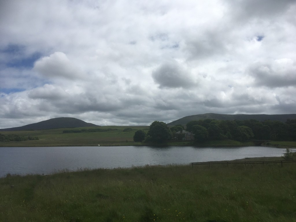
I passed through the village of Morton and then Tibshelf (which up until that moment I genuinely believed was nothing more than quite a good motorway service station), over the M1 and then east, turning right on Chesterfield Road. The road curved up a hill and suddenly a small road, again to the right, and I was on Newtonwood Lane. A couple of hundred metres and I was at the brow of a hill, with a small area of off-road gravel to the left and I was there. I parked up, a bit disorientated by the sheer lack of grandeur. I got out of the car. On the north side of the road, a perimeter fence and beyond a network of small buildings and the concrete flattop of what was self-evidently a reservoir (reservoirs may feature at some of the other top of the county locations).
Newtonwood Lane – The Reservoir (note endangered blue sky)
I looked around for something. In my research it had been evident that the top point in the county was highly disputed. Fortunately, I didn’t discover the bogus (hey, you erect a sign and make a claim you gotta back it up) claims of nearby Strawberry Bank until after my visit, otherwise I might have been driving around all night, but the old SiIverhill colliery,** which I had assumed was where I was standing at, did make the claim and had erected a powerful statue of a kneeling miner at the summit.
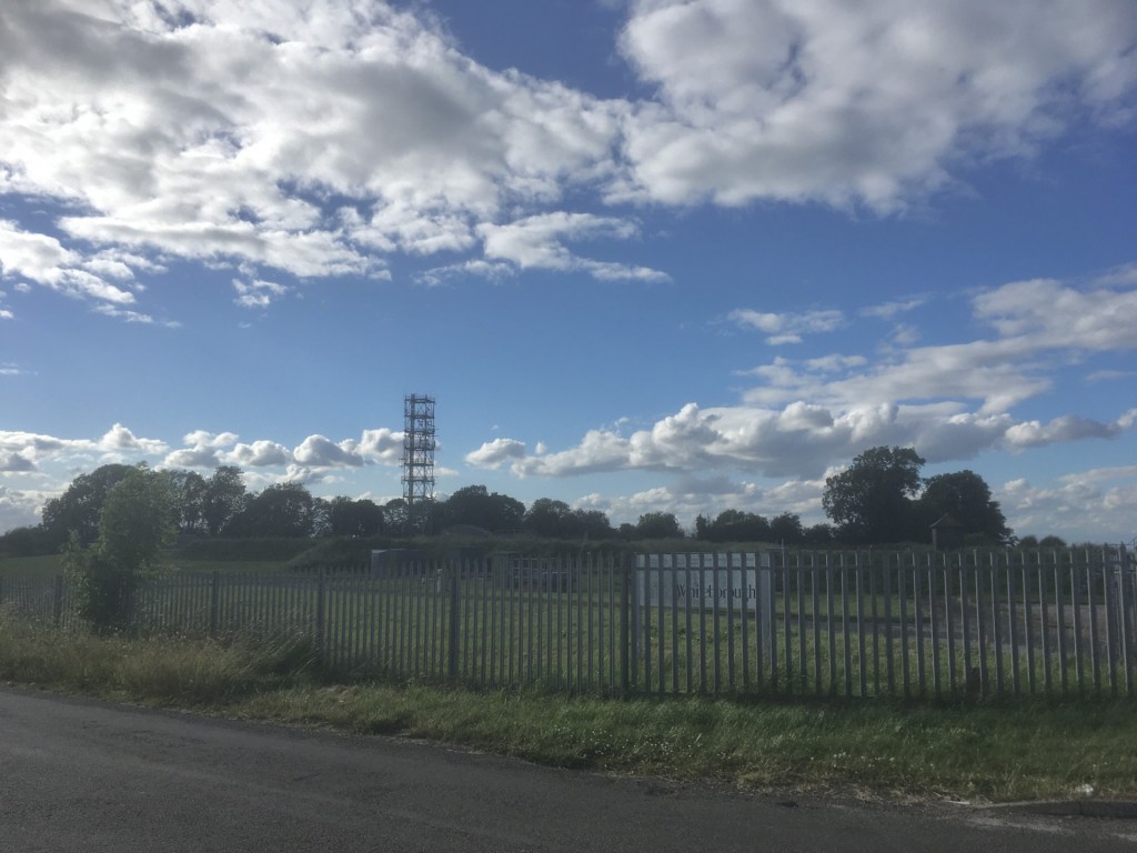
Where I stood bore no resemblance to what I had imagined the Silverhill nature reserve to look like. This was a scrappy area (similar to many scrappy areas of countryside just outside our cities the length and breadth of the land) with none of the proclaimed woodland walks and commanding views. Just over a hedge, by my parked car, a field fell away gently, and a huge electricity pylon reared up just a few metres in. If the miner’s statue was hiding anywhere around here it was doing a good job and I had little or no intention of making further enquiries. Despite some minor reservations I was pretty sure I was at the right spot and had indeed crested the county of Nottinghamshire. And if there was any doubt at all, I concluded that the top of the adjacent pylon was a slam dunk.

Newtonwood Lane looking south. The highest point?
I drove on back and as I entered the village of Morton there was a sign. Morton – The Heart of England. Could this be true? Not only had I crested the highest point in Nottinghamshire, but moments later I had reached the very beating heart of England. And just a bit further into the village hey presto, the Sitwell Arms, to my right, which spoke to me and said “son, you’ve had a busy day, come on in.” How could I refuse?
After a slow pint and some further Googling I discovered that the Silverhill site was about half a mile further to the east, but no worries, after some locals had brought into question its claim to be the highest point, and in 2010 the various high points had been remeasured and there was now no doubt that Newtonwood Lane was the top dog and Strawberry Bank wasn’t even in the running. Strawberry Banks claims may have been a sham, but Morton’s claim to be the most central point in England by north, south, east and westerly coordinates seemed to be entirely genuine, and it seems much underplayed.
Back at the campsite, just a short distance from middle England, I huddled over the radio to listen to England play India in the T20 cricket World Cup semi-finals. It was cool and overcast, but not as wet as in the West Indies. Seems I had brought the Scottish weather with me. As England stumbled towards an emphatic defeat (they were probably very lucky to have been in the semi-final in the first place), I considered that one of the unintended consequences of this rather bizarre project, to go to the top points in each county, was exactly what I had hoped. Reaching places I would never have considered going to. The small, tightly knit towns and villages of this county borderlands area of England have long histories and untold stories but I, and I suspect most others, have never heard of them, and whether or not I was in the East Midlands, or the North, it didn’t seem to matter. The background to those gritty 1950’s and 1960’s films is still there, but the subject matter has changed for good.
Nb The States allowed the close family member in. Phew!
*If you search on Google for the highest point in West Lothian the answer is conclusively West Cairn Hill. So, when I was reading up on East Cairn Hill, which is slightly higher, it said that three counties, including West Lothian, meet at the top. Doubts!
**The Silverhill Colliery closed in 1993, just nine years after the end of the miners’ strike. The statue of the kneeling miner at the top of the artificial hill is called Testing for Gas. The view is supposed to be impressive and on a good day takes in five counties.

One thought on “Cresting the County – Nottinghamshire”