Haddington Hill
267 metres
876 feet
21st July 2024
Chilterns Two Peaks Challenge – Part 1
I’ve struggled to work out how to start this relatively short narrative. This is an account of how, in the middle of August I walked to the top of Buckinghamshire, and then Hertfordshire, in just over a couple of hours. But, for the sake of the purity of the project, do I separate these accounts or not?
Whilst I’m working on how to square that circle, here’s something to think about. Trusting, or not, in information on the internet in respect of the accuracy of heights and locations will, I’m sure, feature somewhere.
I have decided to stick to two separate accounts. This is the account of a walk from my car to the highest point in Buckinghamshire. Having reached that point I then carried on into Hertfordshire. That slightly longer tale can be found here
https://wordpress.com/post/elcolmado57.wordpress.com/764
A couple of weeks earlier I had been contacted by an old work colleague suggesting a meet up in London. It had been some years and sounded like a good idea. I had suggested Wednesday 21st July and had made an arrangement to stay with my youngest brother in north London the night before. Unfortunately, the next day my old colleague had to cancel, and so I had an option of going straight home on Wednesday, or, oh yes, a short drive out of north London, then the M25 west and up the A41 and lo, two adjacent high points were available just west of Tring.
On the day it was a warm and sunny morning. I drove into the Tring salient on the A41, and then took a left onto the B4009 toward Wendover.* A mile or so on and a left onto St Leonard’s (a small lane heading up into the woods), and then just before Chiltern Forest Golf Club, a right onto a one way lane that, after a long and winding drive, eventually got me to the large car park at Wendover Woods (where your registration is filmed and you simply pay before leaving – nice!).
I’d opted for the T-shirt n’ shorts look for the day’s tramp, and after donning the walking boots I set off with a 1983 Ordnance Survey Landranger map, a bottle of water, sunglasses and a sun hat. I walked to the very modern and attractive restaurant/coffee shop, found my bearings and walked east and onto the exit road from the car park. Woods of mainly beech stretched away in all directions. After just a couple of minutes, and just before the barrier gates that released the cars that had paid, a break in the fence and a small track led into the forest on my left. A sign indicated that the full path was closed due to trees presenting danger, but that it was still possible to access the cairn. A cairn? Sounded impressive. I looked forward to the sweeping views across Buckinghamshire.
A well-defined path wound through the woods, and then, there it was. Four large stones, three laying down and one standing stone in the middle and surrounded in every direction by trees and heavy undergrowth.
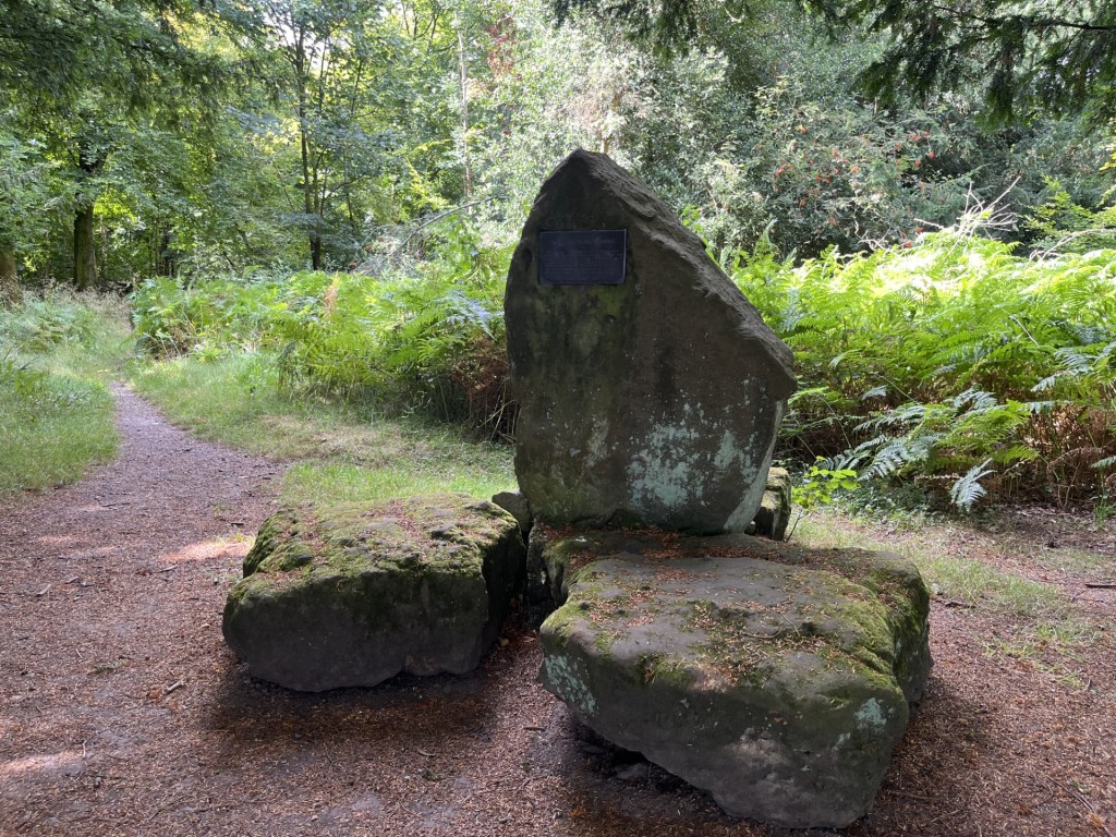
A gathering of stones
A metal plaque informed me that the stone arrangement marked the highest spot in Buckinghamshire and that it had been erected by the Royal Air Force for the local Parish Council in 1977 to commemorate an infamous event that took place that year.** Early June if I remembered correctly. The plaque bore alarming indentations that indicated it had been used for target practice at various points in the preceding years. I wondered if I should duck, just to be on the safe side.

Deep in the east woods. Feeling lucky punk?
The sun had disappeared, and I was beginning to regret not bringing a jumper, but it was too late now. I had the highest point in Hertfordshire to conquer next. I set off back through the woods to the road.
So, that was that – 1977 and, as Polystyrene noted, we were going mad. **
Tick
* The Tring salient is an abstract concept that exists solely in my head. The problem with borders (there’s plenty of scope for further discussion but for the sake of the international order, let’s not), is that by and large they make no sense. If you were to look at a map of the Hertfordshire boundary, at its western limit with Buckinghamshire it should probably end somewhere around Berkhamsted. Instead, a finger reaches out to the northwest and ends beyond Tring in fields near, ironically, Folly Farm, just beyond Long Marston and deep in the Chiltern Hundreds (don’t ask!). Almost certainly some sort of mediaeval territorial land grab thing, but its mark remains.
** 1977 – It wasn’t all street parties. Happy days
