Worcester Beacon
425 Metres
1394 feet
11th September 2024
In the Footsteps of Alfred Watkins – Part One
A couple of weeks earlier, whilst searching for the true top of Hertfordshire, I walked adjacent to a linear section of one of the Grim’s Ditches; iron age earthworks associated with the Chilterns area that still remain a mystery. I discovered that I still owned a fifty-year-old copy of The Old Straight Track, in which the author, Alfred Watkins, claimed, in 1925, to have discovered multiple ancient lines in the landscape. These were called ley lines, based on man-made and natural features, such as burial mounds, churches, standing stones, springs, and other features, which align on the land. I wanted to find out if he had a take on the Grim’s Ditches. He didn’t. I wondered perhaps if this was because they might have undermined his theories, but it’s more likely that he had little knowledge of them, being that most of his research was conducted in the Herefordshire area where he lived, and in particular the Radnor Valley.
Having decided to rule out a late summer getaway to Greece, on the grounds it was going to be too much hassle and inflated prices that didn’t reflect the quality of the accommodation, I decided instead to book a few nights in a studio near Great Malvern, and go seek out some end of season county summits. Given that I was not going to be a million miles from Great Malvern, logic dictated that a walk in the Malvern Hills, and to the top of Worcester (or Worcestershire) Beacon, would make a good start. I packed my bags, threw in my copy of The Old Straight Track, took on a 48-hour grandparenting shift in Bedfordshire, then drove across the Midlands in torrential rain and arrived on Tuesday evening at my digs in the foothills of the Malvern Hills. It was mid-September and unseasonably cold. Wondering if I should have put a bit more effort into the Greek thing, despite the conditions, the late evening view of the hills had me smitten.
After a solid night’s sleep I drove into Great Malvern and parked up just out of the town centre. I was anxious to get on with the walk, and after about 200 metres I realised I was still wearing trainers and not my walking shoes. There’s a difference. As I turned back towards the car park, I also remembered that I hadn’t paid for that either. It’s possibly a getting old thing, but I do need to pay more attention to detail. As it happened, and unlike some other locations I have visited recently, paying at the machine with a card, and without having to type in a load of detail, was a small joy. That said, the 1-hour, 2-hour, 4-hour and 10-hours options (where was 6 and 8?) left me having to select the 10-hour option, just to be on the safe side. At £4 it seemed a fair deal.
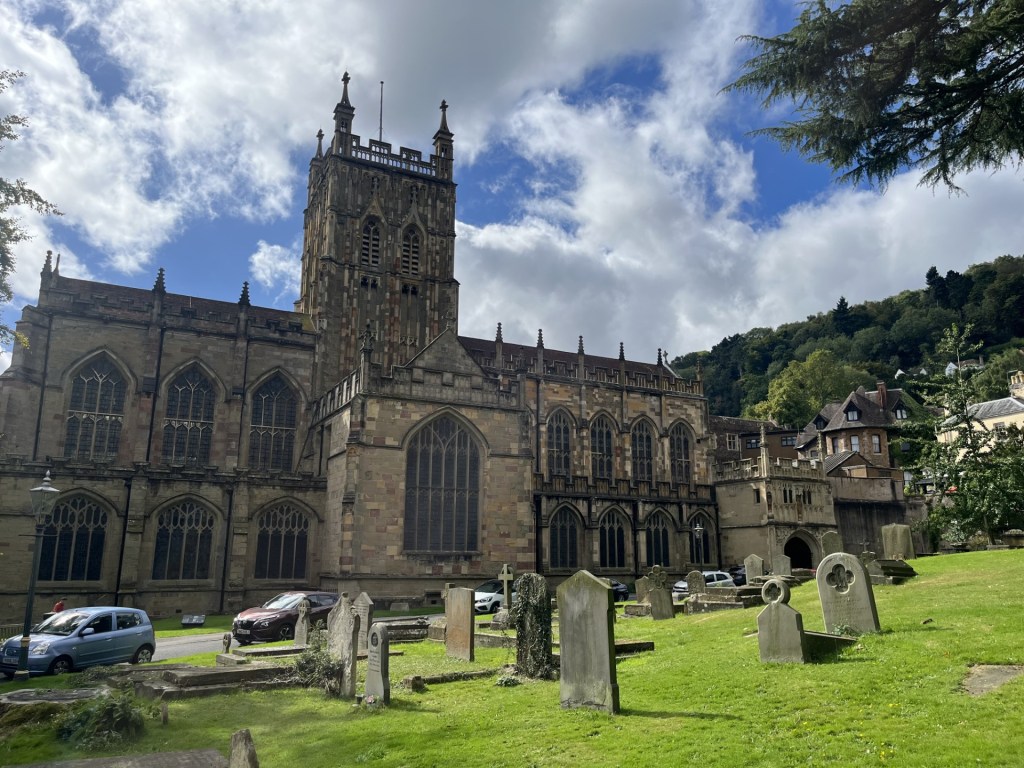
Re-shod, I trotted up the high street and soon arrived at the grounds of the Priory. I knew I had been here before, and had done a walk in the hills, but for the life of me I couldn’t remember when, with who, or why? Maybe it would come back to me as they day progressed. (It didn’t).
Given that I had 10-hours on the meter I felt I had nothing to lose by dropping into the church for a closer inspection. In the back of my mind I had a thought that it housed the original, or at least a copy of the Mappa Mundi.
Into the Priory
I stepped inside, avoiding the curious eyes of the volunteers, eager, no doubt, to pounce. I briefly took in the ceiling tiles and the stained-glass windows that an information board informed me had somehow survived the Dissolution. Another sign said that it costs £20 every 15 minutes to maintain the church. In 1541 locals raised £20 to buy the whole thing to replace their old, dilapidated church. There was no sign of the Mappa Mundi. *
I moved towards the centre of the building. As I did so I became aware of a small gathering at the far end, and a person of the church dressed in a gown, giving a service to a group of people. He was wired up and I was able to hear the reading. I had no idea what the message was, but I did pick up on the line “O ye of little faith.” Taking it as a cue I chose to leave and head instead for a higher place.
The vicar (?) had obviously seen me coming and had slipped in what I took to be an ecclesiastic diss. Duly patronised, I left without further exploration and headed up to Bellevue Terrace, the holy cuss still ringing in my ears. I noticed that there was an abundance of greeting card shops, and as I headed north along the A449 another card shop boasted that it had been nominated in the Best Independent Greeting Card Retailer in the Midlands! Who knew?
I had no specific route in mind, but figured if I continued along this road I would be able to walk the ridge from one of its northern entry points. Here, the A449 is the Worcester Road. Occasionally, between the grand Georgian and early Victorian mansions that lined the road to the right, tantalising views opened towards the Vale of Evesham. The people who built and lived in these imposing houses had certainly picked their spot.
After half a mile or so I took a left onto West Malvern Road. The road went up here into the Cowleigh area (I knew it was the Cowleigh area because a sign pointed out that it was the Crowleigh Area), and after another half mile, on the left at North Quarry, a small car park and what was obviously a route to the hills. Starting up the path on the left I spotted a blue plaque on the wall of what appeared to be the last house in town, and dedicated to Alice Betteridge, the last donkey-woman of the Malvern’s. Rather than jumping to improbable conclusions, I figured that perhaps some more context was necessary.
The steep path headed back south, with a sheer drop to the left of what was obviously one of the huge quarries at the north end of these hills, now overgrown. After another half mile or so, the path began to level out, then a sharp right and it began to zigzag up through oak woodland. After twenty minutes or so I was suddenly out of the trees, the ridge opening out to the south, and down to the left Great Malvern and the priory, abbey, church, whatever, and where, no doubt, the faithful were still celebrating the earlier eviction of the heathen intruder.

Heaven’s Above..
I had an option on the path here. Left, or right and back on north. I sat for a while on a stone and took in the view. Nearby, three young men in modern outdoor wear were discussing the view. One appeared to be in charge and was making encouraging noises to the other two about how they were getting a grasp on what they were seeing in front of them and how that translated onto the maps they were holding. And they were beginning to get it. I figured that it must have been part of a mobile phone detox project, and frankly I’m all in favour. I could see a train heading directly towards me along a straight bit of track, and beyond, Worcester. Time to get on.
I should perhaps say something about the weather at this point. It was bright and mainly sunny, which should have been good, but very unusually for this time of year an arctic blast was brewing up and, like Napoleonic troops in column after column, banks of clouds marched relentlessly overhead from north to south. One minute I was in sunshine and down to my T-shirt, the next rapidly re-dressing. Based on the years weather to date, how it hadn’t rained so far remained a mystery.

They came on, in the same old way
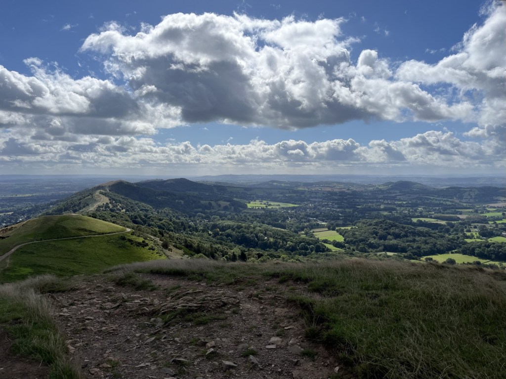
Following the path around the northern flank, with the tops of a hundred hills in every direction, a route up to the top of North Hill presented itself. It was clear at this point that I had missed a trick. If I had carried on past the North Quarry car park, I would have been able to start the climb of the granite ridge at its most northern point. Too late now. I pushed straight on up the steep bank, eventually arriving on level ground with Worcester Beacon directly ahead, and the ground rising again to the left and right.

Looking south. Worcester Beacon – the main objective
Without giving it a second thought I went right, and up. At the top I looked over to the east where North Hill was obviously slightly higher. A minor detail, but for a purist it might have been important. The path then descended rapidly to a saddle where I sat for a while and watched a kestrel looking for its lunch. Already the views were of the highest quality. Far to the west I could make out the Brecon Beacons, and the unmistakable conical shape of Sugar Loaf (which my daughter, her partner and I had climbed in early May, and where the idea of scaling county tops had been kindled **).
Having chosen to approach the summit from the west, as I started on the long drag up, the wind, angling in from the north-west began to tell. Layers were going back on, but it mattered little as the views towards Herefordshire, and Wales beyond, just got better and better. The granite ridge of the Malvern Hills runs precisely north/south, and similar but slightly lower ridges on similar alignments could be picked out to the west.
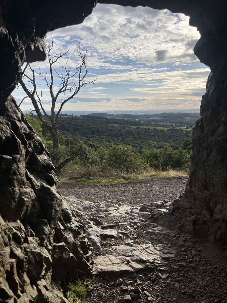
Approaching the summit the wind was beginning to blow a proper hooley. Clumps of grass were being driven flat to the ground and I was beginning to flag. Spotting a cave just above, and needing some respite, I clambered up a bank and entered. It provided little or no extra protection. I took a quick photo and fled. With the broken grey, blue, pink granite beneath my feet, I made the short drag to the top as quickly as I could.

A cold hole
At the summit I might as well have been standing in a wind machine set to max. A circular plinth, erected sometime in the 19th century, and honouring some monarch or other, who I am absolutely certain never visited this spot, marked the top. I stood in the gale for five minutes, watching, through steaming eyes, a group of four middle aged men take innumerable photos of each other. Wishing them to give up the land to allow me a brief second or two at the top, eventually I butted into the party and looked at the large circular toposcope (new word) on the top of the plinth. With my eyes still streaming, and feeling like a gate crasher, I had no time to take in the details except to note that Snowdon was 99 miles away, and in the direction where the wind was thwacking in from. With my hands and whole body shaking I took a photo, figuring I would study it in more detail later. When I checked it later it failed to pass muster, so you’ll have to make do with a couple of panoramas instead.

Having made it to the top I slipped over to the calmer east side of the ridge. Heading south, and with the wind less of a factor, this was walking for the sheer joy of it. The views in every direction were phenomenal. Bit by bit the paths began to descend, and aware that I would soon be losing these astonishing vistas, I sat for a bit above another abandoned quarry. Given the amount of excavation evident, closing these quarries some decades ago was probably for the best, otherwise the chance of there being anything left of the hills now would be remote.
Looking to the south-east, something in the valley below caught my attention. I long, straight line in the landscape! Before leaving the accommodation in the morning, I spent a bit of time mugging up on Alfred’s Watkins understanding of the Malvern Hills area. Surprisingly there wasn’t a lot to go on, although he speculated on a possible ley line starting on a point on the ridge further south which aligning with a cave and a stone below, before disappearing west to an oak tree at Gospel Oak (not Camden’s), and then through two churches and ending at Aconbury Camp (you’ll just have to use your imagination unless you decide to disappear down a rabbit hole). ***

In search of ley’s
The observed long, linear ditch in the landscape, flanked by a line of trees (Watkins advocates strongly about trees and their relevance to ley lines), made me reach for the Ordnance Survey map. Had I discovered the yet to be discovered Malvern Wells/Bredon Hill ley? I immediately located the line on the map, represented by hatched marks. Incredibly, I could track back to the Hills and a starting point where a tumulus was shown on the ridge. Heading further east, beyond the avenue/ditch, the ley precisely crossed with a mediaeval bridge at Upton upon-Severn and ended (as far as I could tell) at the very top of Bredon Hill, some six or seven miles further east. The most extraordinary thing about this ley line was that between Upton upon-Severn and Bredon Hill, it exactly bisected the southbound Strensham service station on the M5 motorway! What otherworldly powers were at work when that happened? With the map flapping away in the wind, and with my mind blown even further, I took one last glance at the linear feature on the map. Huh! I looked again and sure enough I could make out some cryptic writing – dismtd rly. How could I have been so foolish? Or maybe (surely not), when the Great Western Railway built the line almost two hundred years ago, those working on the ground were more in touch with nature and……. (goes on forever).
With these thoughts dancing around like fairies in what was now left of my brain, I wandered on and eventually reached the end of the northern section of the hills at Upper Colwall (essentially there is a northern third, a central section that ends at Little Malvern, and then a southern third that starts at British Camp and tails off a few miles further south beyond Hollybush).
A road crossed my path at the saddle of the hill. I was still in the mood to explore further south, but every step in that direction would mean a longer shift getting back to Great Malvern. A sign indicating a cafe downhill to the west tempted me in that direction. On a lamppost a yellow AA sign directed travellers onwards to the National Collection of Michaelmas Daisies. I hadn’t the foggiest notion of what a Michaelmas daisy might look like, although daisies came to mind. It would either be very nice, or niche, or intriguingly maybe both. I headed on down towards a building that housed the cafe, and with nothing other than an invigorating cup of tea on my mind, reacted almost too slowly when the door of a parked car shot open. Being taken out by a stationary vehicle at this point in the journey would have been a tad disappointing, but somehow my body reacted sufficiently to avoid a painful impact. The perpetrator looked more startled than I felt, apologised profusely, and delightfully an incident of footpath rage was averted.
Reaching the building, still slightly shaken, but grateful that I hadn’t been on a bike, it was disappointing to find the cafe closed. On the flip side, a sign on the window indicated that it hosted the British Society of Dowsers. Now, that was niche! Watkins, whilst not claiming that dowsing assisted him in any way in his search to prove the existence of ley lines, does, in his introduction, indicate an affinity with the ancient craft. It helps form the narrative that humans are intrinsically more in touch with nature and the earth than we understand, and that essentially, we have lost our ability to interact with nature in ways that our ancient ancestors were.
I am not going to suggest that I completely reject that notion. Things do happen, and well, you know! When I was around 15 years old, in the early 1970’s, one afternoon after school a few of us were hanging around on a green on the estate, aimlessly doing what aimless teenagers do. Nothing. A friend, Jim, was arsing around with a Y shaped stick. Shaking his arms around he claimed to have discovered an underground water source, which on closer inspection was a metal cover to a drain owned and managed by the local Water Board. Just at the point when his antics were running out of steam (i.e. everyone had lost interest), his wrists began to gyrate frantically, and the stick pointed in the direction of a manky stray dog that was approaching across the grass. “Leave it out Jim,” someone shouted, at just the moment when the dog, now just feet from him, stopped, cocked a back leg, and did his business. It was proof enough.
With the idea of a refreshment now deeply embedded, I climbed back to the top and followed Old Wyche Road over the saddle and in the direction of the town. Not far on stood The Wyche Inn, so naturally I went in, bought a cola and a bag of crisps and sat in the warming sun. Refreshed, I set off north on the road back into town. More grand houses lined the right side of the road, and more old quarries kept appearing to the left. I hadn’t particularly relished the idea of the last leg, knowing that it must have been at least a couple or miles or more, but in what seemed to be a blink, I was at the outskirts of the town and with just a short distance to go. I looked between two large houses and across the Vale of Evesham. Whilst the sun still shone, a monster storm was tipping millions of buckets of water into the Severn valley. At such moments, and given the location, a touch of Elgar dancing in the air from one of the grand Edwardian windows might have been appropriate, but as I knew no Elgar, and all the windows were firmly closed it remained an enigma and the moment was missed. Alert to the danger I quickened my step, slid down an alley just as the edge of the storm arrived, and in the nick of time found dry sanctuary under the arch of a church door. The downpour was over within a couple of minutes. No dowsing was required.
Two hours on and I was walking across Castlemorton Common towards a local inn. I stopped and looked back towards the Malvern Hills. I’ve never been there, but something about the view reminded me of an African savanna.
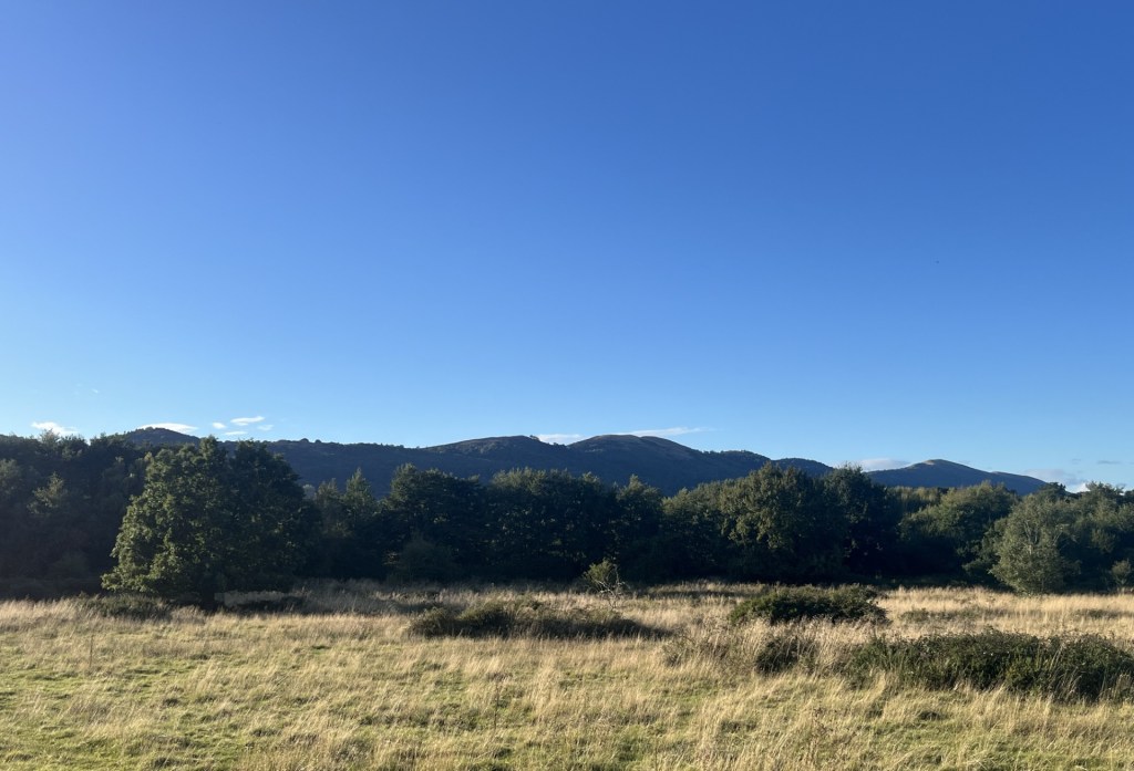
Castlemorton Common – AKA The Worcester Veldt
In his quest to prove the existence of ley lines, Watkins frequently encounters rustic “locals” enjoying a pint of warm beer at country inns. In these moments they recount to him stories that he tentatively claims endorses his understanding of a nearby feature, such as some standing stones. Almost always the narrative begins with something like, “Of course, they’s do says around these ‘ere parts tha’ when a red moon rises over the Blattered Elm, the three Plastered Knights of Old Pishup do rise from the earth, climb up the walls of Cwm O’rbard Castle and there do take an ancient brew from the larst well of Uncertain Origin.” Underestimate at your peril this type of verbal history. Watkins, keen to latch onto any old tale (sorry, fact), certainly didn’t.
On the drive back from the hills I had stopped at the inn to check if it was open, and more importantly, doing food. As I approached the front door it opened and out stepped a middle-aged man holding a pint of the local ale, wearing agricultural clothing, with long curly hair and beard, a ruddy complexion and a rollie between his left earlobe and sideburns. I entered the pub, which clearly hadn’t changed one bit in decades, and was told that they would be serving food after six, and that was fine by me.
As I approached the inn on foot, just after six, I was certain, and excited by the prospect, that if I stayed there for an hour or two it would only be a matter of time before one of the old locals (possibly even my man from earlier), in true Watkins style, would enlighten me on a local myth or legend. I entered at just the moment my man was leaving for the night. The pub was now half full, and everyone, builders, buyers, businessmen and women alike, were gazing intently at their mobile phones.
After a satisfactory pint of Best and a hearty meal, it was time to head home. As I approached the door the woman behind the bar wished me goodnight, and then, as an afterthought added, “Oh, and sir, do mind the old stone on your way out.”
*
* Seems the Mappa Mundi is in Hereford Cathedral. Two days later I took a train to Hereford, found it to be a pleasing town, and spent an hour in the excellent cathedral library, where the Mappa Mundi can also be found hanging, more or less, intact.
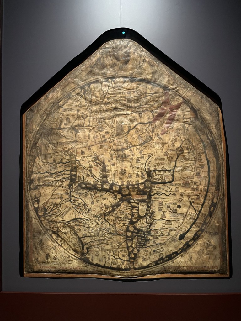
Hereford is bottom left, just next to Crete
** Sugar Loaf is the highest peak in Monmouthshire. But Chwarel y Fan is the highest point, which means that sometime in the future I will need to revisit Monmouthshire. Mind you, worse things can happen.

Sugar Loaf in May – Not the highest point in Monmouthshire!!!
*** Two days after the walk I had time to climb up to Herefordshire Beacon (British Camp), at the start of the southern section of the Malvern Hills. Not surprisingly it’s located in Herefordshire, and despite being quite high, is not the highest point in that county so I can’t claim it. But I would have kicked myself if I had not chosen to do it. The most spectacular Iron Age hill structure I have ever been to. As it was late in the afternoon, and with the sun setting, the views were mind bending.

Beat that!
With a bit of time on my hands I walked south, and with Watkins alignments still troubling my imagination, I eventually located Clutters Cave (AKA Giants Cave). The area below the cave was heavily overgrown, with two green woodpeckers flitting between the trees. I had no desire to go rooting in the brambles for what he believed to be a sacrificial stone that formed part of the ley line.

Alfred Watkins mate, being sacrificed a hundred years ago. These days it’s called sunbathing
I entered the cave and was immediately struck by a ghostly black handprint on the back wall. Clearly evidence of neolithic cave art, and I was surprised that Watkins hadn’t noticed or mentioned it back in 1924. Or maybe it was a Banksy? Either way, and whatever the explanation, I looked out from the cave, and with the dipping sun blushing the Welsh borderlands, I could easily see how it was possible to hang a mystery around the location, and speculate on a time when our ancestors navigated astral planes rooted to points, natural and manmade, on the landscape.
It’s all in the mind, or is it?
A mile or so to the west, below the ridge, lies Eastnor Castle and park. Except it’s not a castle at all. It was built whilst Napoleon was meeting his match in Belgium. As there is no mention in any literature or works of art of Clutter’s Cave before this time, it seems pretty likely that it was dug out to form an estate folly. Sorry Alfred, but not all the leys align after all.
